Browse Listings in Europe > Luxembourg
![[Lot of 25 leaves of France, Brabant, Netherlands, Luxemburg]](/uploads/cache/48264-250x250.jpg)
[Lot of 25 leaves of France, Brabant, Netherlands, Luxemburg]
1552 MÜNSTER, S. - Twenty-five text leaves with wood block illustrations relating to France, Brabant, the Netherlands and Luxembourg
Date: Basel, 1552
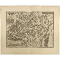
Lutzenburgen sis Ducatus Veriss. Descript.
An attractive map of Luxembourg: title cartouche on the lower left corner. From 'Theatrum Orbis Terrarum [Atlas of the Whole World]'.Iacobo Surhonio Montano auctore. D...
Date: Antwerp, 1598
Lutzenburg.
A lovely miniature map of the small, landlocked European country of Luxembourg, published by Petrus Bertius, in Amsterdam at the beginning of the seventeenth century. The...
Date: Amsterdam, 1606

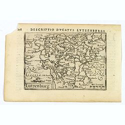
Lutzenburgensis Ducatus veriss descript.
Prepared by Jacob Surhon who made a manuscript map of Luxembourg for which he received 500 Livres from Charles V in 1551. For security reasons the map was not published. ...
Date: Antwerp, 1609
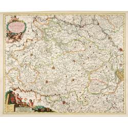
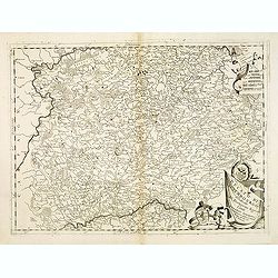
Ducatus Lutzenburgi Novissima et Accuratissima Delineatio.
West to the top. Very detailed and fine map of Luxembourg, including the towns of Namur, Liege, Trier and Metz.
Date: Amsterdam, 1680
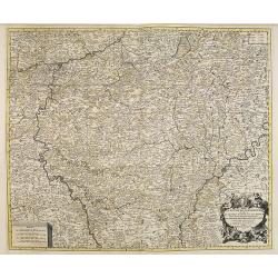
Le Duché du Luxembourg . . .
Fine map of the Duchy of Luxemburg with a figurative title cartouche and two small scales.The map notes Nicolas Sanson as the mapmaker and claims that the map was publish...
- $300 / ≈ €264
Date: Amsterdam, 1692
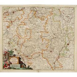
Ducato di Luxembourgo . . .
A beautiful and flamboyantly engraved map of Luxembourg. The map is the product of the late 17th century Venetian cartographer, Vincenzo Coronelli. A decorative title car...
Date: Venice, 1698
Ducatus Lutzenburgi Nova et Accurataa Tabula. . .
Rare issue of Justus Danckert's attractive map of Luxembourg. Decorative title cartouche lower left hand corner.
Date: Amsterdam, 1700
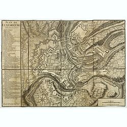
Plan de Luxembourg.
Beautiful engraved plan of the city of Luxembourg, accompanied by a table of references.
- $500 / ≈ €439
Date: Paris, 1741
II. Carte du D.é de Luxembourg.. Seign.rie de Lyege &c.
Charming small map representing part of the Walloon Region, south to Liège. From Atlas Portatif Universel, by Robert de Vaugondy.Edited by : "Au dépôt de Géographie,...
Date: Paris, later than 1749
III. Carte du D.hé de Luxembourg.. Cronenburg &c.
Charming small map representing part of the Walloon Region, southeast to Limburg. From Atlas Portatif Universel, by Robert de Vaugondy.Edited by : "Au dépôt de Géogr...
Date: Paris, later than 1749
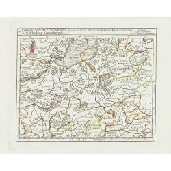
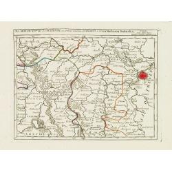
IV. Carte du Duché de Luxembourg où sont les Seign.ries de Lompré..
Charming small map representing part of Luxembourg, the southernmost province of Wallonia and of Belgium.From Atlas Portatif Universel, by Robert de Vaugondy. Edited by :...
Date: Paris, later than 1749
V. Carte du D.hé de Luxembourg.. dans le Lyegeois.
Charming small map representing part of Luxembourg, the southernmost province of Wallonia and of Belgium. Centered on Bastogne.From Atlas Portatif Universel, by Robert de...
Date: Paris, later than 1749
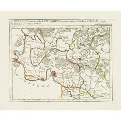
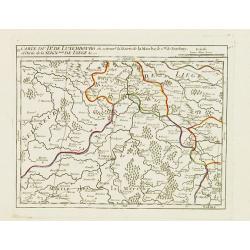
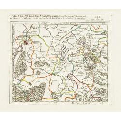
VII. Carte des Frontieres du Luxembourg.. Yvoix &c.
Detailed small map showing an area straddling the border between France and Belgium.From Atlas Portatif Universel, by Robert de Vaugondy. Edited by : "Au dépôt de Gé...
Date: Paris, later than 1749
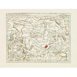
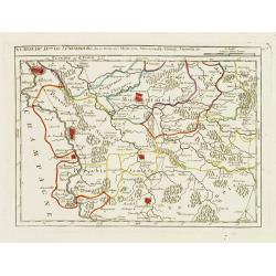
IX. Carte du D.ché du Luxembourg.. Diekirch &c.
Charming small map representing the area between Luxembourg and Trier. From Atlas Portatif Universel, by Robert de Vaugondy.Edited by : "Au dépôt de Géographie, Rue ...
Date: Paris, later than 1749
X. Carte du D.ché de Luxembourg.. Jametz &c.
Nice small map encompassing the northwestern part of Lorraine. Showing Mouzon, Stenay, Montmedy..From Atlas Portatif Universel, by Robert de Vaugondy. Edited by : "A...
Date: Paris, later than 1749
