Browse Listings in Europe > British Isles
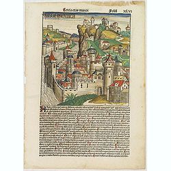
Tercia Etas Mundi. Folium.XLVI (An English town view)
Large woodcut depicting an imaginary English town (235x223mm.) and on the verso the genealogy of King David.Page from the richest illustrated Incunable, the famous: Chron...
Date: Nuremberg, 12 July 1493

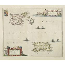
De zee cuften tufschen Dovere en Orfords nesse, daer de Teemse de Vermaerde Rivire van Lonen gelegens is. . .
A detailed chart of the English Channel coastland. Decorated by a colorful title cartouche and scale cartouche, one compass rose, several vessels and sea monsters. A very...
Date: Leiden, Plantijn, 1585

Belchrijuinghe vande zee custen van Engelandt. . .
A rare Dutch text edition of this detailed early chart of the northern coast of England. West to the top. The mileage cartouche has no Latin captures. Decorated by a colo...
Date: Leiden, Plantijn, 1585

Caerte der Noordt cufte van Engelandt, beginnende van Robinhodes baij tot Coket Eijlandt. . . .
A very early Dutch text edition of this detailed chart of the northern coast of England. The mileage cartouche has no Latin captures. West to the top.Decorated by a color...
Date: Leiden, Plantijn, 1585

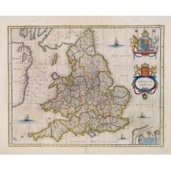
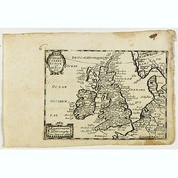
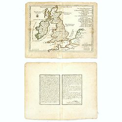
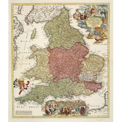
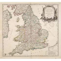
Angliae Regni florentissimi nova descriptio..
Fine general map of England derived from Mercator's 1564 map of the British Isles in 8 sheets.Dare to go in Black. All early maps were printed in black and white; many we...
Date: Antwerp, 1598

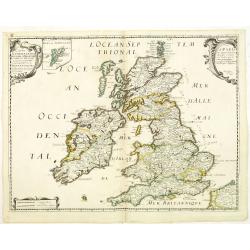
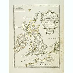
Angliae, scotiae, et Hiberniae, sive Britannicar:insularum.
Fine general map of the British Isles and Ireland on horizontal projection with north to right of page. Derived from Mercator's 1564 map of the British Isles.Dare to go i...
Date: Anwerp, 1598
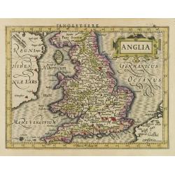
Anglia.
Map of England, from the first French-text edition of Jodocus Hondius'' Atlas Minor.Shortly after the publication of the big folio-atlases the need was apparently felt fo...
Date: Amsterdam, 1608
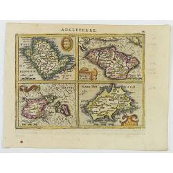
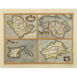
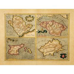
Anglesey Ins. / Wight.. / Ins. Garnesey. / Ins. Iarsey.
A reduced version of Mercator's folio map with four maps on one sheet depicting the English islands of Jersey, Guernsey, Wright and Alderney.Each map is embellished with ...
Date: Amsterdam, 1608
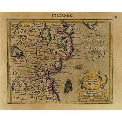
Ultonia Oriental.
Map depicting part of Ulster, with the south-western tip of Scotland in the upper right. From the first French-text edition of Jodocus Hondius' Atlas Minor.Shortly after ...
Date: Amsterdam, 1608
Northumbr. Cumberladia Dunelm. Episcop.
A map of the most northern part of England, from the first French-text edition of Jodocus Hondius' Atlas Minor.Shortly after the publication of the big folio-atlases the ...
Date: Amsterdam, 1608

Udrone.
Map depicting present-day County Carlow in Leinster Province & Catherlaugh which is now Carlow. From the first French-text edition of Jodocus Hondius' Atlas Minor.Sho...
Date: Amsterdam, 1608

Angliae, Scotiae, et Hiberniae, sive Britannicar : Insularum descriptio.
A rare and ornate map with inset portraits of James First, Henry Prince of Wales Princess Anne of Denmark.Janssonius acquired the copperplate of van den Keere's 1604 Brit...
Date: Amsterdam, 1621
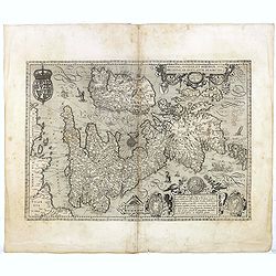
Angliae, Scotiae, et Hiberniae, sive Britannicar : Insularum descriptio.
A rare and ornate map with inset portraits of James First, Henry Prince of Wales Princess Anne of Denmark.Janssonius acquired the copperplate of van den Keere's 1604 Brit...
Date: Amsterdam, 1621
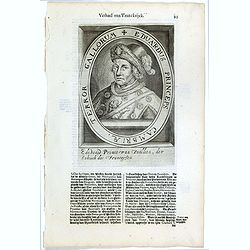
Eduardus Princeps Cambriae, Terror Gallorum.
The engraving depicts a half length oval portrait of Edward Prince of Wales. Nicolaes de Clerck (de Klerc) was active as engraver and publisher in Delft from 1599-1621.In...
- $25 / ≈ €22
Date: Amsterdam, Cloppenburch, 1621
Anglesey. / Iarsay. / Carnesay. / Wight Vectis Olim.
Four maps on one sheet depicting the English islands Jersey, Guernsey, Wright and Alderney.
Date: Amsterdam, 1629
Anglesey. / Iarsay. / Carnesay. / Wight Vectis Olim.
Four maps on one sheet depicting the English islands Jersey, Guernsey, Wright and Alderney.
Date: Amsterdam, 1630
Udrone Irlandiae in Catherlagh Baronia.
A detailed map of the Barony of Udrone (modern Idrone) in County Carlow, Ireland The title is surrounded by a strapwork design cartouche topped with calipers & a mile...
Date: Amsterdam, 1630

Irlandiae Regnum.
A very nice map from Ireland.Mercator was born in Rupelmonde in Flanders and studied in Louvain under Gemma Frisius, a Dutch writer, astronomer, and mathematician. The ex...
Date: Amsterdam, 1630
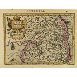
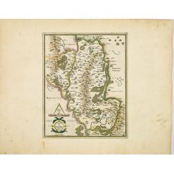
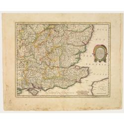
Warwicum Northampton, Huntingdon Cantabr etc.
Showing the south-eastern part of England. From his Atlas Minor. French text on verso.
Date: Amsterdam, c.1630
Warwicum Northamtonia Huntingdonia Cantabrigia..
Showing the south-eastern part of England.
Date: Amsterdam, 1630
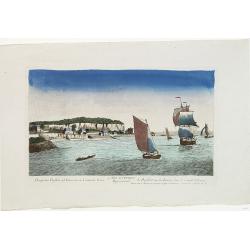
![[L'Hermite's fleet moors in the Solent for repairs.]](/uploads/cache/40472-250x250.jpg)
[L'Hermite's fleet moors in the Solent for repairs.]
In March 1623, a heavily armed fleet of 11 ships, under the command of Jacob l’Hermite, sailed from Holland with the ambitious hope of ‘destroying the Spanish in America’...
Date: Frankfurt, M.Merian, 1633
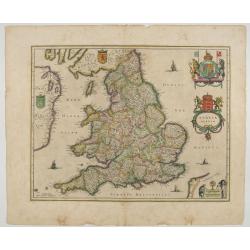
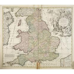
Anglia Regnum.
Janssonius' map of England and Wales was one of the new maps prepared by him in 1636. His map closely copies the similar map issued two years earlier by Willem Blaeu.. Th...
Date: Amsterdam, 1642
Warwicum Northamtonia Huntingdonia Cantabrigia..
Showing the south-eastern part of England.
Date: Amsterdam, 1642
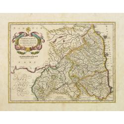
Northumbria, Cumberlandia et Dunelmensis Episcopatus..
Showing the most northern part of England. The map shows Cumbria, Northumberland, Westmorland, Durham, and adjacent parts of Lancashire, Yorkshire, and Scotland.
Date: Amsterdam, 1642
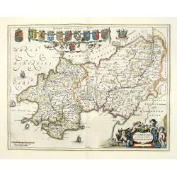
Penbrochia Comitatus et Comitatus Caermaridunum.
Attractive map of the county of Pembroke shire in the UK by J. Blaeu. From a Dutch edition of "Atlas Maior" in beautiful color. With 13 coats of arms, the feath...
Date: Amsterdam, 1648
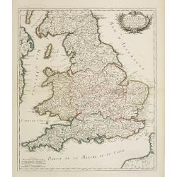
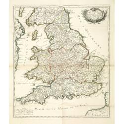
Anglia Regnum.
Willem Blaeu was the first publisher to bring out a new map of England and Wales. The outline and place names are taken from Speed with county boundaries marked but no bo...
Date: Amsterdam, 1650
Carte Generale des Royaume d'Angleterre Escosse et Irlande Avecq les Isles circonvoisines Conues toutes soubs le nom de Britanniques / Nouvellement dressee et tiree de Cambdene Spede & autres Par N. Sanson geogr.e Ord.re du Roy
Fine map of the British Isles. The map was first published by Tavernier and later by Mariette. This edition carries the date 1640 and the address of Pierre Mariette: rue ...
Date: Paris, 1640-1657
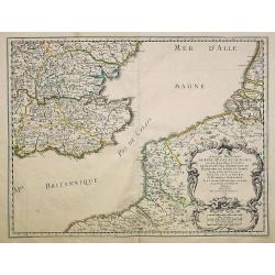
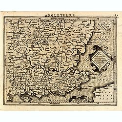
Anciens Royaumes de Kent, d'Essex, et de Sussex. . .
The standard map of South Eastern England with Kent and Essex, Sussex and Cornwall in 17th century France. Engraved by A.Peyrouin.Nicolas Sanson was to bring about the ri...
Date: Paris, 1654-1659
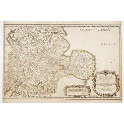
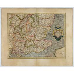
Anciens Royaumes de Mercie, et East Angles. . .
The standard map of the Middle Eastern part of England with Chester, Leicester, Oxford, Cambridge, etc., in 17th century France. Engraved by A.Peyrouin.Nicolas Sanson was...
Date: Paris, 1654-1659
Sarnia Insula vulgo Garnsey et Insula Caesarea venacule Jarsey
Fine map depicting the English islands of Jersey and Guernsey is entitled : "Sarnica Insulavulgo Garnsey et Insula Caesarea vernacule Jarsey". In the cartouche ...
Date: Amsterdam, 1660
Carte des Isles Britanniques où sont les Royaumes d'Angleterre et d'Ecosse que nous appellons Grande Bretagne et celui d'Irlande avec les isles qui en sont proche . . .
General map of the British isles, with a fine title cartouche upper right with the date 1663 and the complete title reads : "Carte des Îles britanniques où se trouve...
Date: Paris, 1663

Pascaert van Engelant Van t'Voorlandt tot aen Blakeney waer in te sien is de mont vande Teemse.
Two charts on one sheet. One decorative sea chart of the southeast coast of England with an inset of the Thames till London, embellished with two title cartouches, a ship...
Date: Amsterdam, 1666

Het Canaal tusschen Engeland en Vranciick.
An eye-catching chart of the Channel.Pieter Goos (ca. 1616-1675) was one of the most important cartographers, engravers, publishers and print sellers of Amsterdam. His wi...
Date: Amsterdam, after 1666
Angleterre Ecosse et Hibernie.
Rare map of the British islands, published by Jollain in 1667. Published in "Trésor Des Cartes Geographiques Des Principaux Estats de Lunivers".This atlas is ba...
Date: Paris, 1667

Pascaart van de west cust van Engeland en Wales Van S. Davids Point tot de Moul van Dalway.
Rare Doncker's sea chart of the Irish Sea with the west Coast of England (Liverpool), the Island of Man and the western-most tip of Northern Ireland (Bangor) and Souther...
Date: Amsterdam, 1660-1668

.Paskaarte om Achter Yrlandt om te Zeylen van Hitlant tot. . .
An eye-catching chart of Ireland, including the north of England and Scotland, with the West to the top.Pieter Goos (ca. 1616-1675) was one of the most important cartogra...
Date: Amsterdam, 1673
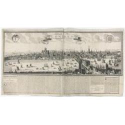
Londres 1678.
Extremely rare panoramic broad sheet panoramic town-view of London from Whitehall to the Tower, with underneath in letter press a description of the town's history. The o...
Date: Paris, 1677
Le Royaume d'Angleterre.
An attractive map centered on England, Wales and the southern part of Scotland. The very decorative cartouche includes a dedication to Jacques II Roy d'Angleterre, d'Esco...
- $650 / ≈ €571
Date: Paris, 1689

Carte de la Manche. . .
Decorative chart showing the Chanel, with the coastline of France from La Baie de Douarnenez to Dunkerque, and the coastline of England from Stroble head to Manning Tree....
Date: Amsterdam, 1692
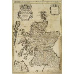
Le Royaume d'escosse divise en partie septentrionale et meridionale. . .
Fine map of Scotland with a decorative title and scale cartouche.This plate is from the newly engraved Dutch counterfeit edition of the "Atlas Nouveau", publish...
Date: Amsterdam, 1692
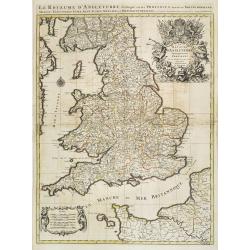
Le Royaume d'Angleterre distingué en ses provinces.
Fine map of England and Wales that is fully and richly engraved. Large and extremely decorative cartouche with angels, flags, seal of England, etc. Six distance scales wi...
Date: Amsterdam, 1693
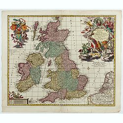
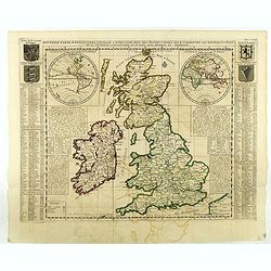
Magnae Britaniae Tabula; Comprehendens Angliae, Scotiae, Ac Hiberniae Regna . . .
Rare Dutch map of the British Isles in very attractive full original color. In this state the wording "Scilly Isles" is added. A decorative title cartouche in t...
Date: Amsterdam, after 1694
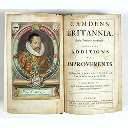
Camden's Britannia, Newly Translated into English with Large Additions and Improvements.
Splendid copy fully original colored (inclusive title-cartouche) of the first edition of Gibson's translation.Illustrated with an engraved portrait of Camden by R. White,...
Date: London, F. Collins for A. Swalle and A. / J. Churchill, 1695
Les Isles Britanniques ou sont les Royaumes . . .
An interesting small map of the British islands by Nicolas de Fer. From his rare "Petit et Nouveau Atlas". The first edition was published in 1697 and was repub...
Date: Paris, 1705
Carte du gouvernement militaire d'Angleterre où l'on représente l'état des officiers de guerre et celui des forces de terre et de mer.
Interesting sheet with a decorative map on the British Isles, with idyllic scenes showing councils of the various military officers of the British Isles, with descriptive...
Date: Amsterdam, 1720
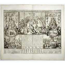
Carte du gouvernement ecclesiastique d'Angleterre . . .
Elegant engraving of the ecclesiastical government of England, with an engraving showing three images: in the centre, an ecclesiastical assembly (Convocation of the Clerg...
- $100 / ≈ €88
Date: Amsterdam, 1720
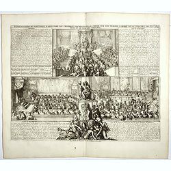
Représentation du parlement d'Angleterre, les chambres assemblées . . .
Engraving showing the British Parliament and an assembly before the King of England. From Chatelain's Atlas Historique, 1732-1739. In upper right margin: 'Tom. 7. No 26.H...
- $80 / ≈ €70
Date: Amsterdam, 1720
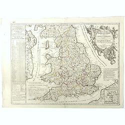
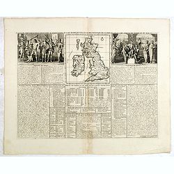
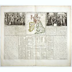
Carte Pour l'Introduction a l'Histoire d'Angleterre, ou l'on Voit son Premier Gouvernement, et l'Etat Abrege de cette Monarchie sous les Empereurs Romains, et sous les Rois Saxons.
The sheet includes a large inset map of Roman Britain including the English Channel and the western coast of France (200 x 255mm.). It also provides a wealth of informati...
- $200 / ≈ €176
Date: Amsterdam, 1720
Carte du gouvernement d'Angleterre où l'on représente l'Etat des officiers de Guerre. . .
Decorative map on the British Isles, with idyllic scenes showing councils of the various military officers of the British Isles. Henri Abraham Chatelain (1684 – 1743) was...
- $50 / ≈ €44
Date: Amsterdam, 1720
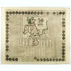
Nouvelle carte d'Angleterre, d'Ecosse et d'Irlande, avec des instructions ..
Striking large folding map of the British Isles, with large insets of the Eastern and Western Hemispheres and the coats of arms for England, Ireland, Scotland and Wales. ...
Date: Amsterdam, 1721

Urbium Londini et West-Monasterii nec non Surburbii Southwark Accurata Ichnographia ,., Neuester Grundris der Staedte London und West-Munster, Samt der Vorstadt Southwark ,.,
Detailed plan of London, extending from Grosvenor Square in the west to Mile End to the east, To the right inset views of St, James's Square, and Custom House, elevations...
Date: Nuremberg, 1736
Magnae Britanniae pars meridionalis in qua regnum Angliae. . .
Johann Baptist Homann's well-engraved map has a large decorative cartouche at top right and a large scene at bottom center showing a throned ruler, presumably George I, h...
Date: Nuremberg, 1740
Regni Angliae et Wallae principatus Tabula, divisa in LII Regiones. . .
A detailed and decorative map of England, with an attractive uncolored title cartouche. The map is a re-issue of Carolus Allard's map. The elaborate title cartouche in th...
Date: Amsterdam c. 1744
Le royaume d'Angleterre..
Fine map of England and Wales. As well as country details, including the main post roads. Le Rouge was active from 1740- till 1780 as a publisher, and was appointed engin...
Date: Paris, 1745
Le royaume d'Angleterre divise en comtez et baronnie. . .
Beautiful map of England, published by le Rouge.
Date: Paris,1745

Itinera Varia Auctoris.
From A Natural History of Uncommon Birds, and of some other rare and undescribed Animals, Quadrupeds, Reptiles, fishes, insects, &c.. The map shows Edwards' journeys ...
Date: London, 1746

A view of Westminster bridge. Vue du pont Westminster.
A very decorative and extremely rare collection of river Themes and Westminster Bridge in London, including a six-line description in French and English. Published by Jac...
Date: Paris, ca.1750
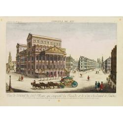
Vue de l'Hotel du Lord Maire, qui comprend.. (London)
In the eighteenth and nineteenth centuries there were many popular speciality establishments in Paris, Augsburg and London which produced optical viewing devices and spec...
Date: Augsburg 1750
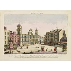
Vue de la Maison de Northumberland a Charing Cross. . .
In the eighteenth and nineteenth centuries there were many popular speciality establishments in Paris, Augsburg and London which produced optical viewing devices and spec...
Date: Augsburg 1750
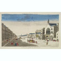
Vue perspective du palais episcopal de Westminster.
So-called optical print illustrating a perspective view of the old Palace of Westminster where the Lords and Commons met and the square facing it.. Published by Jacques C...
Date: Paris, ca. 1750

Vue de l Hotel du Lord Maire, qui comprend la Façade, et le Cot' Occidental de Londres.
Shows the famous Lord Mayor's coach driving through London. The Lord Mayor's coach is famous for its role in the Lord Mayor's Show, which is one of the longest-establishe...
Date: Augsburg, 1750

A View of S. James's Palace Pall Mall. - Vues du Palais royal de S.Jacques Pall Mall.
So-called optical print illustrating a perspective view of St James's Palace, Pall Mall. The gatehouse of St James's Palace is on the left.In the eighteenth and nineteent...
Date: Paris, 1753
Paskaart Vande Noord Cust van Schotland als mede de Eylanden van Hitland en Fero. . .
Decorative chart, with south to the top. Latitude scale, compass rose and system of rhumb lines, soundings, anchorage's, etc. In the lower right corner, with added number...
- $500 / ≈ €439
Date: Amsterdam, 1753
Le Royaume D'Angleterre, divise selon les sept Royaumes ou Heptrachie des Saxons, avec La Principaute De Galles, et subdivisie en Shires ou Comtes…
Decorative map of British Isles divided into the 7 ancient Heptarchies of the Saxons and also showing the more modern counties or shires. With Rococo title cartouche. Eng...
Date: Paris, 1753
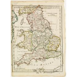
L'Angleterre.
Fine map of England and Wales. George Louis Le Rouge was active from 1740- till 1780 as a publisher, and was appointed engineer for the King of France. From his Atlas Nou...
Date: Paris 1756
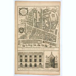
Tower Street Ward with their Divisions into Parishes according to a New Survey.
A fascinating plan of Tower Street Ward, one of the 25 City of London Wards. It lies close to the Tower of London. Much of the ward was lost to Billingsgate Ward in bound...
Date: London, 1757
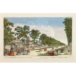
A View of the Grand Walk &c in Vauxhall gardens taken from the Entrance. Publish'd according to Act of Parliament..
So-called optical print illustrating Vauxhall gardens.In the eighteenth and nineteenth centuries, there were many popular specialty establishments in Paris, Augsburg and ...
Date: London, 1759

Vue Interieure de la Bourse Royale à Londres.
So-called optical print of the London stock exchange. Daumont was a well-known publisher of optical prints, established in Paris. In the eighteenth and nineteenth centuri...
Date: Paris, 1760
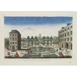
Vue et perspective d'un Jardin du Roy d'Angleterre aux environs de Londres.
So-called optical print of one of the King's Royal Gardens in the London vicinities.Published by the brothers Chéreau, active in Paris at rue St. Jacques au dessus de la ...
Date: Paris, 1760
Prospectus Purfleet ad Tamesim in Comitatu Essex Representant le Purfleet sur la Tamise dans le Comté d'Essex. 21e VUE d'Optique.
A so-called optical print of the vessel Purfleet navigating on the River Thames in Essex, England. Published by the brothers Chéreau, active in Paris at rue St. Jacques ...
Date: Paris, 1760
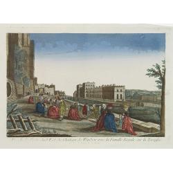
Vue de la Partie Sud Est du Château de Windsor avec la Famille Royale sur la Terrasse. Et vue du Palais de la Reine.
A so-called optical print view of the Royal family at the terrace of the South East wing of Windsor Castle as well as the Queen's Palace. Published by the brothers Chérea...
Date: Paris, 1760
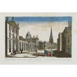
Universatis ae Reginae Collegiorum prospectus Oxfordiae Représentant le College de l'Université, et celui de la Reine a Oxford. 63 Vue d'optique.
A so-called optical print of Queens College on High Street in Oxford. As most optical prints, due to the fact that they are used to be looked at in a mirror, the subject ...
Date: Paris, 1760
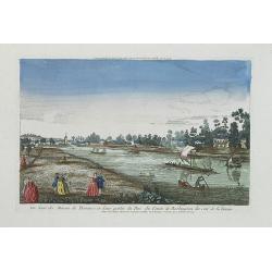
Vue d'une des Maison de Plaisance et d'une partie du Parc du Comte de Burlington du Coté de la Tamise.
A so-called optical print of Burlington County and the River Thames. Published by the brothers Chéreau, active in Paris at rue St. Jacques au dessus de la Fontaine St. Se...
Date: Paris, 1760

5e Vue d'Optique Representant La Vue interieure de la Cathedralle de St. Paul de Londres.
So-called optical print illustrating a perspective view of the interior of the Saint Paul cathedral in London. Engraved by la Marcade.In the eighteenth and nineteenth cen...
Date: Paris, 1760
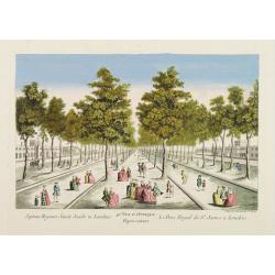
40e Vue d'Optique Representant Le Parc Royal de St. James a Londres.
So-called optical print illustrating a perspective view of Saint James Park, in London.In the eighteenth and nineteenth centuries there were many popular speciality estab...
Date: Paris, 1760

39e Vüe d'Optique Representant L'Hotel du Lord Maire de Londre.
So-called optical print illustrating a perspective view of Somerset House on the Strand in London.In the eighteenth and nineteenth centuries, many popular specialty estab...
Date: Paris, 1760

26e Vüe d'Optique Representant L'Abbaye de Westminster et de l'Eglise Ste. Marguerite à Londres.
So-called optical print illustrating a perspective view of Westminster Abbey, in London.In the eighteenth and nineteenth centuries, many popular specialty establishments ...
Date: Paris, 1760

Vuë du dedans de l'Eglise de St. MARTIN à Londre.
So-called optical print illustrating a perspective view of the central aisle of St. Martin's church, in London.In the eighteenth and nineteenth centuries, many popular sp...
Date: Paris, 1760
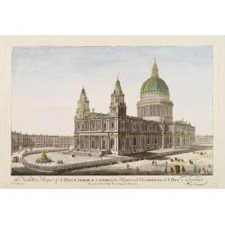
The North West Prospect of S. Pauls Cathedral in London.
Uncommon optical print illustrating a view of St. Paul's Cathedral in London.In the eighteenth and nineteenth centuries there were many popular speciality establishments ...
Date: Paris, 1760
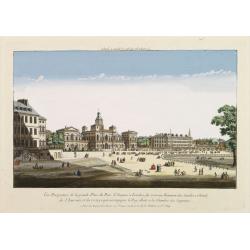
Vüe Perspective de la grande Place du Parc St. Jacques à Londres, du nouveau Batiment des Gardes a Cheval, de l'Amirauté..
So-called optical print illustrating a cortege of subjects accompanying the king to the House of Lords along the Horse guards Road in St. James's Park, in London.The Old ...
Date: Paris, 1760
