Browse Listings in Europe
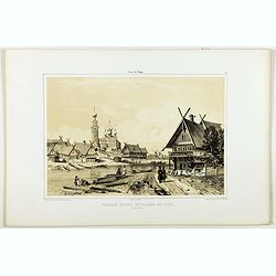
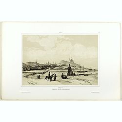
Village entre Novgorod et Tver.
A view of a village between Novgorod and Tver, as on 12 of August 1839. River Volga on foreground. Figures are lithographed by Raffet. Plate taken from the first illustra...
- $150 / ≈ €127
Date: Paris, 1844
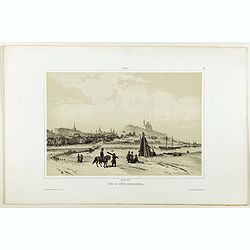
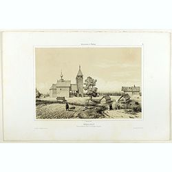
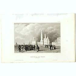
Vue de côté merodional.
A view of the village Vladimir. Figures are lithographed by Raffet. Plate taken from the first illustrated account of Russian architecture. This publication was the proje...
- $150 / ≈ €127
Date: Paris, 1844

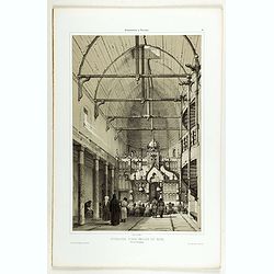
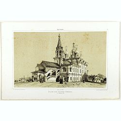
Intérieur de l'église du Monastère de la Ste Trinité.
A view of the Ste Trinity Monastery. Figures are lithographed by Raffet. Plate taken from the first illustrated account of Russian architecture. This publication was the ...
- $100 / ≈ €85
Date: Paris, 1844
Intérieur d'une église en bois, près de Kineschma.
A view of a church's inside, made of wood. Figures are lithographed by Raffet. Plate taken from the first illustrated account of Russian architecture. This publication wa...
- $100 / ≈ €85
Date: Paris, 1844

The church of Vasili Blagennoi Moscow.
Original steel engraving of St. Basil's Cathedral in Moscow, after a design by Alfred Gomersal Vickers (1810-1837) engraved by James Harfield Kernot (1802-1858).
- $20 / ≈ €17
Date: London and Paris, 1844
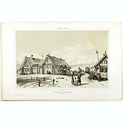
Village de Goumnisthe entre Kostroma et Yaroslaw..
A view of Goumnisthe village. Figures are lithographed by Raffet. Plate taken from the first illustrated account of Russian architecture. This publication was the project...
Date: Paris, 1844
Eglise des saintes femmes.
A view of a church, the 5 of September 1839. Figures are lithographed by Raffet. Plate taken from the first illustrated account of Russian architecture. This publication ...
Date: Paris, 1844
Nikolskoï paroisse entre les villes de Soudogda et Mouroum.
A view of an old church. Figures are lithographed by Raffet. Plate taken from the first illustrated account of Russian architecture. This publication was the project of C...
- $150 / ≈ €127
Date: Paris, 1844
Vue du côté méridional.
A view of an old village. Figures are lithographed by Raffet. Plate taken from the first illustrated account of Russian architecture. This publication was the project of ...
- $150 / ≈ €127
Date: Paris, 1844

ÉGLISE SAINT OUEN, A ROUEN. Dessiné d'après nature par Chapuy. Lith. par Deroy.
Original lithograph of Saint Ouen cathedral, situated in Rouen. Lithographed by Deroy after a design by Chapuy and printed in Paris by Lemercier, Bernard Cie.
- $125 / ≈ €106
Date: Paris, 1844

FACADE DE LA CATHÉDRALE A CHARTRES. Dessiné d'après nature par Chapuy. Lith. par Deroy.
Original lithograph of Chartres Cathedral's facade. Lithographed by Deroy after a design by Chapuy and printed in Paris by Lemercier, Bernard Cie.
- $125 / ≈ €106
Date: Paris, 1844

INTERIEUR DE L'EGLISE SAINT OUEN A ROUEN. Dessiné d'après nature par Chapuy. Lith. Par Arnout. Fig par Bayot.
Original lithograph of the inside of Saint Ouen chruch, situated in Rouen. Lithographed by Arnout and Adolphe-Jean-Baptist Bayot (Alessandria 1810 - 1866) after a design ...
- $50 / ≈ €42
Date: Paris, 1844

ÉGLISE St. VINCENT A ROUEN. Dessiné d'après nature par Chapuy. Lith. par Monthelier. Fig. par Bayot.
Original lithograph of St Vincent cathedral, situated in Rouen. Lithographed by Jules Monthelier (1801-1883) and Adolphe-Jean-Baptist Bayot (Alessandria 1810 - 1866) afte...
- $80 / ≈ €68
Date: Paris, 1844

TOMBEAU DU DUC DE BREZE, DANS LA CATHEDRALE DE ROUEN. Dessiné d'après nature par Chapuy. Lith. par Monthelier. Fig. par Bayot.
Original lithography of the tomb of the duke of Brézé, in the cathedral of Rouen. Lithographed by Jules Monthelier (1801-1883) and Adolphe-Jean-Baptist Bayot (Alessandr...
- $50 / ≈ €42
Date: Paris, 1844

INTERIEUR DE LA CATHEDRALE A CHARTRES. Dessiné d'après nature par Chapuy. Lith. Par Bachelier.
Original lithograph of the inside of the cathedral situated in Chartres. Lithographed by Bachelier after a design by Chapuy and printed in Paris by Lemercier, Bernard Cie...
- $50 / ≈ €42
Date: Paris, 1844
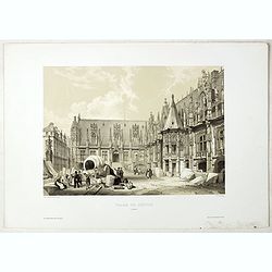
PALAIS DE JUSTICE A ROUEN. Dessiné d'après nature par Chapuy. Lith. par Rouargue.
Original lithograph of the courthouse of justice in Rouen. Lithographed by Rouargue after a design by Chapuy and printed in Paris by Lemercier, Bernard Cie.
- $150 / ≈ €127
Date: Paris, 1844

ARC DE TRIOMPHE A ORANGE. Dessiné d'après nature par Guesdon. Lith. par Ad. Cuvellier. Fig. par Bayot.
Original lithograph of the Triumph Arc of Orange. Lithographed by A. Cuvillier and Adolphe-Jean-Baptist Bayot (Alessandria 1810 - 1866) after a design by Chapuy and print...
- $100 / ≈ €85
Date: Paris, 1844

PORTAIL SEPTENTRIONAL DE LA CATHÉDRALE A CHARTRES. Dessiné d'après nature par Monthelier. Lith. par Monthelier.fig. par Bayot.
Original lithograph of the northern portal of Chartres cathedral. Lithographed by Jules Monthelier (1801-1883) and Adolphe-Jean-Baptist Bayot (Alessandria 1810 - 1866) af...
- $75 / ≈ €64
Date: Paris, 1844
COMMERCY, Vue prise de la Garenne - Chemins de fer de l'Est. Dessiné d'après nat. et Lith. par A.Maugendre.
Original lithograph eye-bird view of Commercy, as seen from La Garenne. Lithographed by Jules Monthelier (1801-1883) and Adolphe-Jean-Baptist Bayot (Alessandria 1810 - 18...
Date: Paris, 1844
The church of Vasili Blagennoi Moscow.
Steel engraving of St. Basil's Cathedral in Moscow, after a design by Alfred Gomersal Vickers (1810-1837) engraved by James Harfield Kernot (1802-1858).
Date: London, 1844
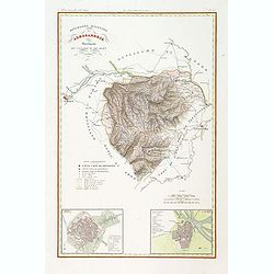
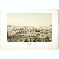
Divisione Militare di Alessandria. Provincie di Casale e di Asti.
"Published in ""Atlante Geografico dell' Italia"". With inset cartouche with detailed plans of the cities of Asti and Casale. Showing the river P...
Date: Florence, 1845
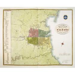
Pianta della citta di Palermo e dei suoi contorni.
Published in Atlante Geografico dell' Italia . Uncommon and decorative town-plan of Palermo. With a numbered key.Engraved by P. Manzoni.
Date: Florence, 1845
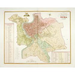
Pianta della citta di Roma.
Published in "Atlante Geografico dell' Italia". Uncommon and decorative town-plan of Rome. With a numbered key. Engraved by P.Manzoni.
Date: Florence, 1845

Optique de St.Cloud.
This perspective view of St. Cloud comprises 6 hand colored images of the grand Bassin d'Apollon viewed through an square and two round holes cut out from the front card ...
Date: Paris, ca.1845
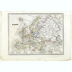
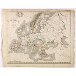
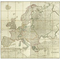
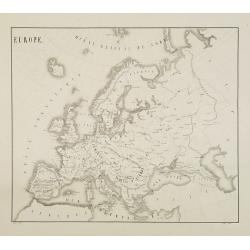
Europe.
Detailed Europe map, prepared by Charles V. Monin (fl.1830-1880) a French cartographer of Caen and Paris. Published in Atlas Universel de Géographie Ancienne &c Mode...
- $50 / ≈ €42
Date: Paris, 1845
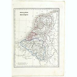
Hollande et Belgique.
Detailed Holland and Belgium map, prepared by Charles V. Monin (fl.1830-1880) a French cartographer of Caen and Paris. Published in Atlas Universel de Géographie Ancienn...
- $50 / ≈ €42
Date: Paris, 1845
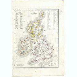
Iles Britanniques.
Detailed British Islands map, prepared by Charles V. Monin (fl.1830-1880) a French cartographer of Caen and Paris. Published in Atlas Universel de Géographie Ancienne &a...
- $25 / ≈ €21
Date: Paris, 1845
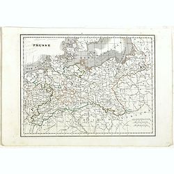
Prusse.
Detailed map of Prussia, prepared by Charles V. Monin (fl.1830-1880) a French cartographer of Caen and Paris. Published in Atlas Universel de Géographie Ancienne &c ...
- $40 / ≈ €34
Date: Paris, 1845
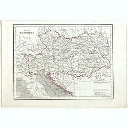
Empire d'Autriche.
Detailed map of Austria, prepared by Charles V. Monin (fl.1830-1880) a French cartographer of Caen and Paris. Published in Atlas Universel de Géographie Ancienne &c ...
- $25 / ≈ €21
Date: Paris, 1845
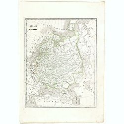
Russie d'Europe.
Detailed map of European Russia, prepared by Charles V. Monin (fl.1830-1880) a French cartographer of Caen and Paris. Published in Atlas Universel de Géographie Ancienne...
- $25 / ≈ €21
Date: Paris, 1845
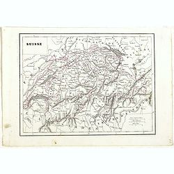
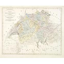
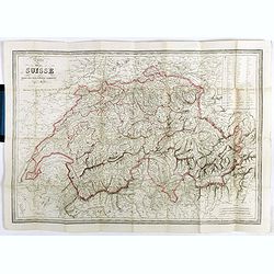
Suisse.
Detailed map of Switzerland, prepared by Charles V. Monin (fl.1830-1880) a French cartographer of Caen and Paris. Published in Atlas Universel de Géographie Ancienne &am...
- $45 / ≈ €38
Date: Paris, 1845
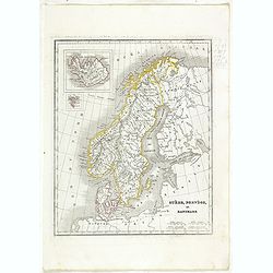
Suède, Norvège et Danemark.
Detailed map of Sweden, Norway and Denmark, prepared by Charles V. Monin (fl.1830-1880) a French cartographer of Caen and Paris. Published in Atlas Universel de Géograph...
- $35 / ≈ €30
Date: Paris, 1845
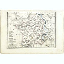
La Gaule sous l'Empire Romain.
Detailed map of France, prepared by Charles V. Monin (fl.1830-1880) a French cartographer of Caen and Paris. Published in Atlas Universel de Géographie Ancienne &c M...
- $25 / ≈ €21
Date: Paris, 1845
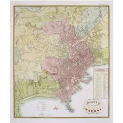
Pianta della citta di Napoli.
Published in Atlante Geografico dell' Italia. Uncommon and decorative town-plan of Naples. With a numbered key.Engraved by P.Manzoni.
Date: Florence, 1845

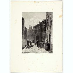
Het Klooster ten Hage (Marienhage Eindhoven)
Very rare lithography of the ruin of the monastery of Ten Haghe in Eindhoven. Lithographed by M.Mouret, published in "oud-Nederland en de uit vroegere dagen overgebl...
Date: Nijmegen, 1837-1846
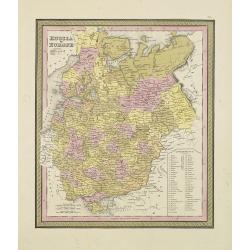
Russia in Europe.
From S. Augustus Mitchell’s "A New Universal Atlas". Philadelphia. Lithographic transfer from engraved plate. A fine map of Russia in Europe from the mid-nine...
- $80 / ≈ €68
Date: Philadelphia, c.1846
![[Untitled map of Black Sea].](/uploads/cache/37349-250x250.jpg)
[Untitled map of Black Sea].
Very detailed and rare map of Black Sea region. The map has elaborate floral borders. Prepared by Joseph Scheda in Vienna.
- $200 / ≈ €169
Date: Vienna, 1845-1847
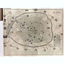
Nouveau plan illustré de la ville de Paris . . .
Fine plan of Paris, engraved by Taylor. "With the complete system of its fortifications and strong detached". Adorned with many vignettes engraved with monument...
- $900 / ≈ €762
Date: Paris, 1847
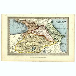
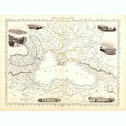
Armenia major, Iberia etc. by J.Archer.
Early Missionary map of Armenia from the "Atlas of educational maps for the use of schoolmasters" (1847), published by SPCK - the Society for Promoting Christia...
- $150 / ≈ €127
Date: London, 1847
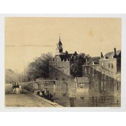
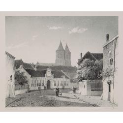
The Hague
Attractive lithography showing a street scene in The Hague. Lithographed by Jan Weissenbruch, published by K.Fuhri, included in Kunst Kroniek.
- $40 / ≈ €34
Date: The Hague, 1848
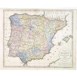
Karta öfver Spanien och Portugal.
An very rare map of Spain and Portugal with Swedish text. This is an updated version of his map of 1819 and is now dated 1833.From his atlas "Geographisk Hand-Atlas&...
- $100 / ≈ €85
Date: A. Wiborgs förlag, Stockholm, ca. 1848
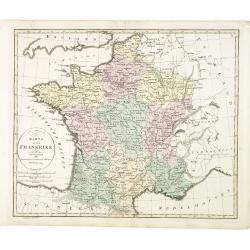
Karta öfver Frankrike.
An very rare map of France with Swedish text. This is an updated version of his map of 1819 and is now dated 1831.From his atlas "Geographisk Hand-Atlas" first ...
- $100 / ≈ €85
Date: A. Wiborgs förlag, Stockholm, ca. 1848
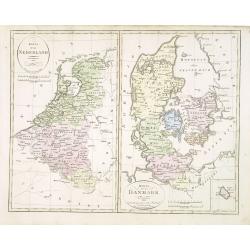
Karta öfver Nederland. / Karta öfver Danmark.
An very rare map of The Low Countries and Denmark with Swedish text. This is an updated version of his map of 1820 and is now dated 1832.From his atlas "Geographisk ...
- $110 / ≈ €93
Date: A. Wiborgs förlag, Stockholm, ca. 1848
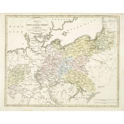
Karta öfver Preussiska riket.
An very rare map of Eastern part of Germany, with Pomerania and part of present-day Poland with Swedish text. This is an updated version of his map of 1820 and is now dat...
- $150 / ≈ €127
Date: A. Wiborgs förlag, Stockholm, ca. 1848
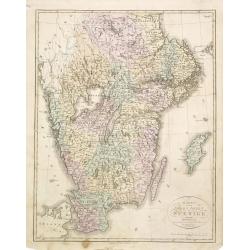
Karta öfver södra delen af Sverige.
An very rare map of Sweden with Swedish text. This is an updated version of his map of 1822 and is now dated 1839. In upper right corner Suppl. 1.From his atlas "Geo...
- $150 / ≈ €127
Date: A. Wiborgs förlag, Stockholm, ca. 1848
Karta öfver Europa.
An very rare map of Europe with a Swedish text. The map is dated 1839.Published as a supplement map in his atlas "Geographisk Hand-Atlas" first published in 181...
- $75 / ≈ €64
Date: A. Wiborgs förlag, Stockholm, ca. 1848
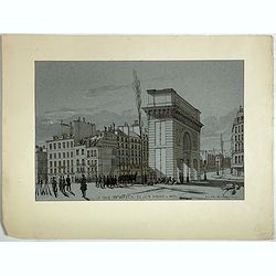
La Porte de S. Martin 24 Juin 3 heures du matin.
A view of St. Martin a well known place in Paris, by the French draughtsman André Durand.
- $100 / ≈ €85
Date: Paris, 1848
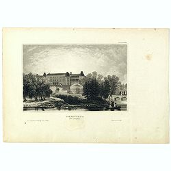
Czaritzana bei Moskau. (Tsaritsyno In Moscow)
Steel engraving with a panoramic view of the Tsaritsyn Palace In Moscow, published in "Meyers Universum oder Abbildung und Beschreibung des Sehenswerthesten und Merk...
- $20 / ≈ €17
Date: Hildburghausen, 1848
Das Zeughaus in Moscau.
Steel engraving of the Kremlin, published in "Meyers Universum oder Abbildung und Beschreibung des Sehenswerthesten und Merkwürdigsten der Natur und Kunst auf der g...
- $25 / ≈ €21
Date: Hildburghausen, 1848
Kloster des Ivan Velekoi in Moscau.
Steel engraving of the Kremlin, published in "Meyers Universum oder Abbildung und Beschreibung des Sehenswerthesten und Merkwürdigsten der Natur und Kunst auf der g...
- $25 / ≈ €21
Date: Hildburghausen, 1848
Kertsch im südlichen Russland. (Kerch)
Steel engraving with a panoramic view of the town of Krech, published in "Meyers Universum oder Abbildung und Beschreibung des Sehenswerthesten und Merkwürdigsten d...
- $15 / ≈ €13
Date: Hildburghausen, 1848

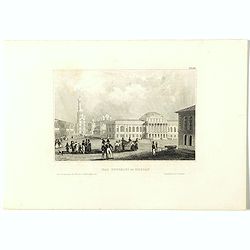
Zarskoe. (Tsarskoye Selo)
Steel engraving with a panoramic view of the town of Zarskoe, published in "Meyers Universum oder Abbildung und Beschreibung des Sehenswerthesten und Merkwürdigsten...
- $20 / ≈ €17
Date: Hildburghausen, 1848
Karta öfver Helvetien.
An very rare map of Switzerland with Swedish text. This is an updated version of his map of 1820 and is now dated 1833.From his atlas "Geographisk Hand-Atlas" f...
Date: A. Wiborgs förlag, Stockholm, ca. 1848
![Bataille de Pultusk, le 26 Decembre 1806. [manuscript map]](/uploads/cache/38810-250x250.jpg)
Bataille de Pultusk, le 26 Decembre 1806. [manuscript map]
Manuscript map of the siege of Pultusk (located on the west bank of the River Narew approximately 50 kilometres (31 mi) north of Warsaw), on 26 December 1806. With a colo...
- $1750 / ≈ €1482
Date: Breda, 1849
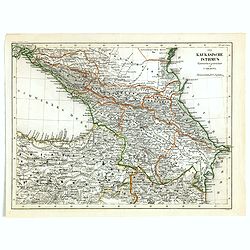
Der Kaukasische Istmus . . .
Detailed contemporary colored map of the countries of the Caucasus Mountains. Steel engraving appeared in "Meyer's Lexicon. Atlas der Geographie". Engraved by C...
Date: Hildburghausen, 1849
Carta geografica statistica e stradale d'Europa diseguata ed insica da Stanislao Stucchi. . . in Milano 1849.
Large engraved folding map of Europe (1545x1570 mm), consisting of 54 plates linen backed, the boundaries in early hand-color.Stanislao Stucchi was an engraver and printe...
- $600 / ≈ €508
Date: Milan, Turin, 1849
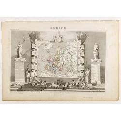
Europe.
While the map itself is quite simple without a great deal of detail, the surrounding engravings make this one of the most decorative 19th century maps. The map is frame...
- $150 / ≈ €127
Date: Paris 1850
Dordrecht.
Attractive lithography showing a Dutch street scene, printed by C.W.Mieling and lithographed by Jan Weissenbruch. Published in Kunst Kroniek .
- $50 / ≈ €42
Date: The Hague 1850

Saint Petersbourg. Maison de bienfaisance, appartenant à Mr Anatole de Demidoff. . .
Beautiful lithography showing the house of Anatole de Demidoff in Saint Petersburg.
Date: Paris, c. 1850

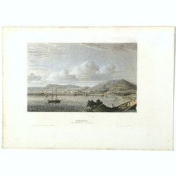
Nice Vue prise audessus de Montalban.
Beautiful view of Nice from the book "l'Italie à vol d'oiseau".
Date: Paris, 1850
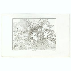
Plan du Champ de Bataille de la Moskowa
Prepared by Thunot Duvotenay (1796-1875), a French geographer and publisher. Detailed map taken from: "Thiers, Atlas de l' Histoire du Consulat et de l' Empire"...
- $150 / ≈ €127
Date: Paris, 1850

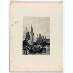
(View of the Moscow Kremlin, seen from the Moskva River in the south).
Anonymous, likely Russian School gouache drawing of Moscow Kremlin. The Kremlin is depicted in a typical 19th century romantic style and is seen from the Moskva river in ...
Date: Russia, ca. 1850

Der Kreml in Moscau.
View of Moscow with in the background the Kremlin. Original steel engraving, published by Bibliographisches Institut Hildburghausen. Engraved by H.Hauser.
- $30 / ≈ €25
Date: Hildburghausen, 1850
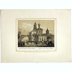
Eglise de Notre Dame de Vladimir.
The church of Holy Mary in Vladimi with in the foreground a ceremony with bishops, monks and faithful viewers. Below a caption in French and in Cyril.
- $45 / ≈ €38
Date: Russia or France, ca. 1850
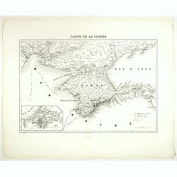
Carte de la Crimée.
Attractive map of Crimea with inset plan of Sevastopol, prepared by Alexandre Aimé Vuillemin (1812-1886). A road system and the ferry lines are drawn in.Engraved by Jaco...
- $150 / ≈ €127
Date: Paris, ca. 1850

Moscau von der Kreml-Seite.
Steel engraving with a panoramic view of the Kremlin in Moscow, published in "Meyers Universum oder Abbildung und Beschreibung des Sehenswerthesten und Merkwürdigst...
- $20 / ≈ €17
Date: 1850
Archangel.
Steel engraving of Archangel, published by the German publishing company Bibliographisches Institut which was founded 1826 in Gotha by Joseph Meyer, moved 1828 to Hildbur...
- $25 / ≈ €21
Date: Hildburghausen, 1850
Carte de la Suisse . . .
Detailed canvas map of Switzerland.
Date: Paris, 1850
Dutch street scene.
Attractive lithography showing a Dutch street scene, lithographed by F.H. Weissenbruch after a painting of Jan Weissenbruch.
- $50 / ≈ €42
Date: The Hague, 1850
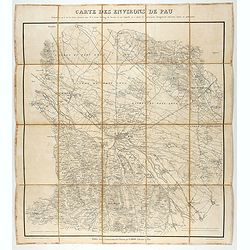
Carte des environs de Pau. . .
Folding map of Pau and its surroundings, being a reduced version of the map by Comte Dulong de Rosnay and engraved by Nicolas Delamare and published by Lafon.More about f...
- $75 / ≈ €64
Date: Pau, Lafon, 1840-1850
![[Original drawing: Fisher's ships on the beach of Scheveningen.]](/uploads/cache/984-250x250.jpg)
[Original drawing: Fisher's ships on the beach of Scheveningen.]
Unique pencil drawing: Typical Dutch beach life with flat-bottomed ships on the beach of Scheveningen. Signed in the lower right corner and on the back site with P.A....
Date: c. 1850
Arnhem
Attractive lithography showing a street scene in Arnhem. Lithographed by Jan Weissenbruch, published by C.W. Mieling, included in Kunst Kroniek.
- $65 / ≈ €55
Date: The Hague, 1851
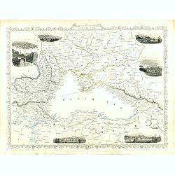
Black Sea.
Decorative steel engraved map of the Black Sea with inset views of Sebastopol and Odessa. There are also vignettes of Constantinople, Sinope and Varna. Taken from "T...
- $110 / ≈ €93
Date: London, London Printing and publishing Company of London, ca. 1851
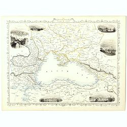
Black Sea.
Decorative steel engraved map of the Black Sea with inset views of Sebastopol and Odessa. There are also vignettes of Constantinople, Sinope and Varna. Taken from "T...
Date: London, London Printing and publishing Company of London, ca. 1851
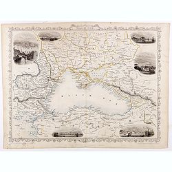
Black Sea.
Decorative steel engraved map of the Black Sea with inset views of Sebastopol and Odessa. There are also vignettes of Constantinople, Sinope and Varna. Taken from "T...
- $90 / ≈ €76
Date: London, London Printing and publishing Company of London, ca. 1851
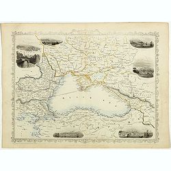
Black Sea.
Decorative steel engraved map of the Black Sea with inset views of Sebastopol and Odessa. There are also vignettes of Constantinople, Sinope and Varna. Taken from "T...
- $90 / ≈ €76
Date: London, London Printing and publishing Company of London, ca. 1851
Black Sea.
Decorative steel engraved map of the Black Sea with inset views of Sebastopol and Odessa. There are also vignettes of Constantinople, Sinope and Varna. Taken from "T...
Date: London, London Printing and publishing Company of London, ca. 1851

Black Sea.
Decorative steel engraved map of the Black Sea with inset views of Sebastopol and Odessa. There are also vignettes of Constantinople, Sinope and Varna. Taken from "T...
- $90 / ≈ €76
Date: London, London Printing and publishing Company of London, ca. 1851
Europe.
Fine manuscript map of Europe with relief shown pictorially. Signed by the author in the lower right corner.Lower left Juillet 1852.
- $150 / ≈ €127
Date: Paris, 1852
![Dépt. De L'Aude. N°10. [ Carcassonne ]](/uploads/cache/27089-250x250.jpg)
Dépt. De L'Aude. N°10. [ Carcassonne ]
Map of the Aude region, centered on the town of Carcassonne. Reaching to the right till the Mediterranean.Lovely map from one of the last decorative atlases of the ninete...
Date: Paris, A. Combette, 1852