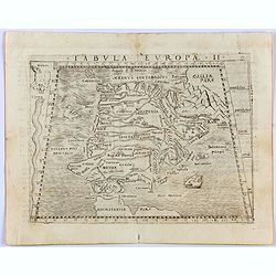
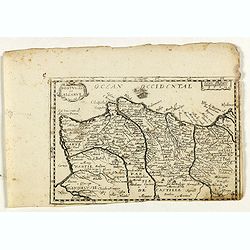
Tabula Europae II. (Spain and Portugal)
Gastaldi's map showing Spain and Portugal, based upon Ptolemy.It is one of the earliest obtainable maps of the region.From Giacomo Gastaldi's Atlas of 1548 which has been...
- $375 / ≈ €328
Date: Venice, 1548
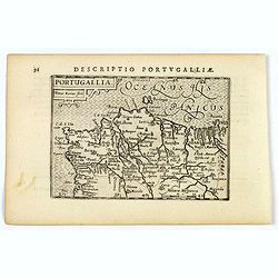
Portugallia.
A nice miniature map of Portugal, published by Petrus Bertius, in Amsterdam, at the beginning of the seventeenth century. North is orientated to the right. Strap-work tit...
Date: Amsterdam, 1606
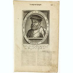
Ionnes III. D. G. Portugaliae Algarbiae etc. Rex. Decimus- Quintus / Henricus I. D. G. Portugaliae Algarbiae etc. Rex. Decimus- Septimus.
The engraving depicts a half length oval portrait of Portuguese Royalties Ionnes III on recto and Henricus I on the verso.Nicolaes de Clerck (de Klerc) was active as engr...
- $45 / ≈ €39
Date: Amsterdam, Cloppenburch, 1621

Portugalliae que olim Lusitania..
1628 MERCATOR, G. / HONDIUS, J. - The best-known map of Portugal, after Alvares Secco
Date: Amsterdam, 1628
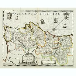
Portugallia et Algarbia quae olim Lusitania. . .
Rare map of Portugal with decorative title cartouche. Oriented to the west. Prepared by Fernando Alvares Seco.
Date: Paris, c.1630
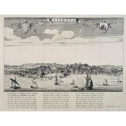
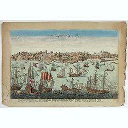
Lisbona.
A rare panoramic view of Lisbon with over the whole length of the lower part 3 columns of poems in Latin, Dutch and French.Published by Dancker Danckerts (1634-1666)Colle...
Date: Amsterdam, 1660
Portugal et Algarve.
Rare map of Portugal, published by Jollain in 1667. Published in "Trésor Des Cartes Geographiques Des Principaux Estats de Lunivers".This atlas is based upon Bo...
- $150 / ≈ €131
Date: Paris, 1667
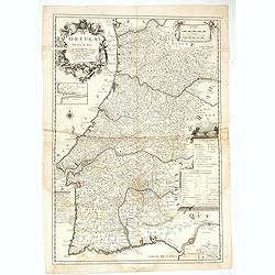
Le Portugal dedié au Roy.
Detailed over-sized map of Portugal prepared by P. Placide Augustin, with fine title cartouche. Engraved by Inselin.Le Père Placide de Sainte-Hélène was the brother-in-la...
- $400 / ≈ €350
Date: Paris, ca. 1700
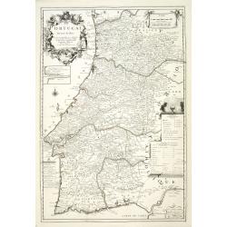
Le Portugal dedié au Roy.
Detailed oversized map of Portugal prepared by P. Placide Augustin, with fine title cartouche. Engraved by Inselin.Le Père Placide de Sainte-Hélène was the brother-in-law...
Date: Paris, ca. 1700
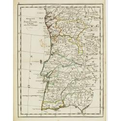
Les Royaumes de Portugal et d'Algarve..
Lovely small map of Portugal showing a panel in the upper right corner with a list of local rulers.From Le Nouveau et Curieux Atlas Geographique et Historique.. by Jacque...
Date: Paris, 1719
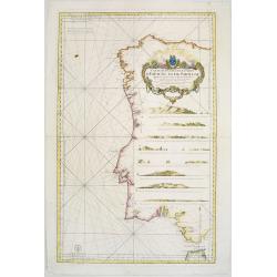
Carte Réduite Des Costes D'Espagne Et De Portugal Depuis le Cap Pinas jusqu'au Détroit de Gibraltar..
Large-scale sea chart covering all of the coast of Portugal, with eight coastal profile insets.The chart was engraved by Herman van Loon. With rhumb lines.Published by th...
Date: Paris, 1751
Royaume de Portugal.
Fine map of Portugal. With date 1743 added in manuscript.George Louis Le Rouge was active from 1740- till 1780 as a publisher, and was appointed engineer for the King of ...
Date: Paris, 1756
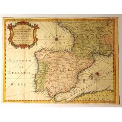
A New and Accurate Map of the Kingdoms of Spain, Portugal and Part of France, The Islands of Majorca, Minorca &c.
Produced for “Universal Magazine” by J. Hinton. It was engraved by Richard William Seale (1703-1762). The map features an attractive rococo cartouche and compass rose wi...
Date: London, ca. 1760
Lisbone Ville Capitale du Royaume de Portugal…
A very RARE panoramic view of the city of Lisbon, including a numbered legend in the lower part : 1-28.The plate, at the joint address of Esnault et Rapilly and Daumont,...
Date: Paris, c. 1760
![[2 maps] Partie Septentrionale.. Partie Meridionale du Royaume de Portugal..](/uploads/cache/25084-250x250.jpg)
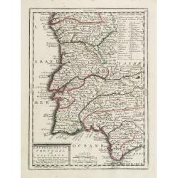
[2 maps] Partie Septentrionale.. Partie Meridionale du Royaume de Portugal..
A detailed two sheet map of Portugal showing the roads, prepared by N.Bellin. Venetian edition of the map by Bellin, to whom Santini gives credit in the cartouche.From &...
Date: Venice, 1776 - 1784
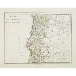
Royaume de Portugal Carte Générale.
Map of Portugal in attractive out-line color.
Date: Paris, 1799
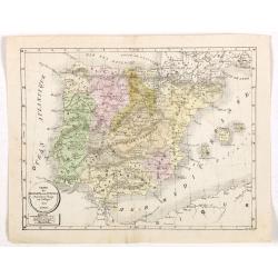
Carte de l'Espagne et du Portugal dréssée pour l'usage des Collèges 1822.
Uncommon lithographed map of Spain and Portugal taken from " Atlas Géographique. Géographie moderne actuelle. Pour l'usage des Collèges."
Date: Paris, 1822
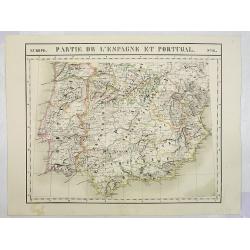
Europe. Partie de l'Espagne et Portugal. N°24.
Detailed map including Southern part of Spain and Portugal.From his famous Atlas Universel . This atlas was one of the most remarkable world atlases ever produced, antici...
Date: Brussels, 1825-1827
