Browse Listings in Asia
![View in the island of Cracatoa. [Rakata in the Sunda Strait]](/uploads/cache/30051-250x250.jpg)
View in the island of Cracatoa. [Rakata in the Sunda Strait]
Early view of the volcano Krakatoa (Indonesian name: Krakatau), on the Indonesian island of Rakata in the Sunda Strait, taken from "Views in the South Seas" bei...
Date: London, Boydell and Co., 1808

The Fan palm, in the island of Cracatoa.
The Fan palm, on the island of Krakatoa (Indonesian name: Krakatau), in the Sunda Strait, taken from "Views in the South Seas" being a very important and early ...
Date: London, Boydell and Co., 1808
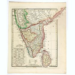
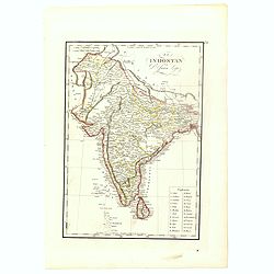
The Southern provinces of Hindoostan . . .
An attractive map showing Hindoostan and Ceylon. Shows towns, rivers, mountains, lakes, etc. In pretty original wash colors. Robert Wilkinson was active in London as a ca...
Date: London, 1808
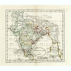
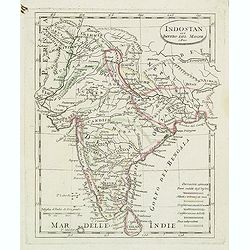
Indoustan ou Inde.
Map of India. The map is based on the Paris Meridian. Only in 1884, at the International Meridian Conference in Washington, D.C., was the Greenwich Meridian accepted.Engr...
Date: Paris, c. 1810
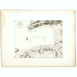
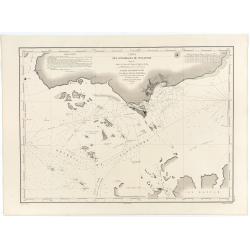
Esquisse de la Baie de Coupang (cote S.O. Ile de Timor) par M. M. Peron et Lesueur, an 1803.
Map of Kupang Bay on the Indonesian Island Timor, prepared by Louis Freycinet during his voyage under Captain Thomas Baudin in 1800-1803. Plate no. 14 from the atlas part...
Date: Paris, Langois, 1811

Charte von China und den angränzenden Ländern und Völkerschaften so wie den letzten Kaiser Tschien-Long. . .
Uncommon map of China on a scale of ca. 1:6,000,000. The map's complete title is “Charte von China und den angränzenden Ländern, und Völkerschaften so wie sie dem letzten...
Date: Parague, 1812
Selling price: ????
Please login to see price!
Sold in 2023
![Hindostan [India]](/uploads/cache/49208-250x250.jpg)
Hindostan [India]
A fine copper engraved map of Hindoostan (now India) drawn and engraved by Alexander Findlay and published by Thomas Kelly, London in 1814
Date: London, 1814

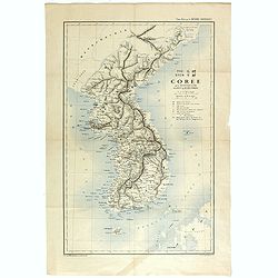
Corea and Japan.
A fine large-scale map of Japan and Korea showing an increasingly refined outline to the Japanese islands but still oversized Korean peninsula. The strait south of Korea,...
Date: Edinburgh, 1816
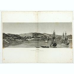
Timor. Vue de la rade, de la ville et du fort de Coupang, dans l'île de Timor.
Nice double page view of the town Kupang, formerly known as Koepang. In the center is the Dutch V.O.C. fort. From Voyage de découvertes aux terres Australes by François P...
Date: Paris, 1807-1816
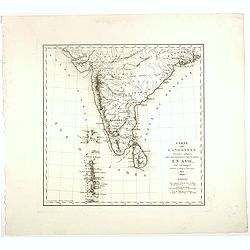
El Indostan por D. Juan Lopez.
Uncommon map of India and Shri Lanka published by Juan Lopez (1765-1830) and included in his "Atlas Universal o collection de mapas nuevos. . ." first published...
Date: Madrid, 1817

Account of a voyage of discovery to the west coast of Corea.
BRITAIN'S FIRST ACCURATE ACCOUNT OF KOREA & OKINAWANS. With an appendix containing charts and various hydrographical and scientific notices by captain Basil Hall and ...
Date: London, 1818

Voyage of his majesty’s ship Alceste, along the Coast of Corea, to the island of Lewchew, with an account of her subsequent shipwreck, by John M’LEOD. Surgeon of the Alceste.
The second and best edition, with a frontispiece portrait of Captain Maxwell and five fine hand-colored aquatint plates, including a plate not present in the first editio...
Date: London, John Murray, 1818

Chungguk-do
Chungguk-do [Map of China] taken from a Korean printed Ch’onha chido [Atlas of all under Heaven] which is a 19th century version of the traditional Korean atlas produced ...
Date: Korea, ca. 1820

Carte de l'Arabie d'après les différents morceaux qu'a donnés M. Niebuh...
Detailed map of the Arabian Peninsula, after Niebuhr, with scales in the lower left corner. Engraved by Pierre-Paul Dubuisson.More about Mapping of Arabia [+]
Date: Paris, ca. 1820
Indostan gia impero del mogol. . .
Charming map of India with Ceylon from the rare atlas Atlante Tascabile o sia Serie di Num. XXI Cartine Geografiche nelle quali si rappresenta in ristretto lo Stato Attua...
Date: Rome, 1823
![Timor. Naba-Leba Roi de L'Ile Solor. [plate XXV]](/uploads/cache/46347-250x250.jpg)
Timor. Naba-Leba Roi de L'Ile Solor. [plate XXV]
A portrait of a male Naba-Leba by Lesueur, from Voyage de découvertes aux terres Australes by François Péron, 1824.The French expedition under Nicolas Baudin, was commiss...
Date: Paris, 1824
![Timor. Canda Jeune fille Malaise. [plate XXVI]](/uploads/cache/46348-250x250.jpg)
Timor. Canda Jeune fille Malaise. [plate XXVI]
A portrait of a female Canda by Lesueur, from Voyage de découvertes aux terres Australes by François Péron, 1824.The French expedition under Nicolas Baudin, was commissio...
Date: Paris, 1824
![Timor. Rhinolophe Cruménifére. [plate XXXV]](/uploads/cache/46357-250x250.jpg)
Timor. Rhinolophe Cruménifére. [plate XXXV]
Plate illustrating Horseshoe bats from Timor Island, by Lesueur, from Voyage de découvertes aux terres Australes by François Péron, 1824.The French expedition under Nicol...
Date: Paris, 1824
Carte De L'Indostan Servant à Indiquer Les Possessions Françaises En Asie.
Map of a part of Asia, with Sri Lanka, From " Nouvel Atlas du royaume de France, ou cartes détaillées des Gaules, de la France à l'époque de 1789, des 86 département...
Date: Paris, 1826

Partie de la Chine. N°.74 (Including South Korea)
Covering the Mouth of the Yangtze area in Jiangsu and Zhejiang, and southwestern Korea with the island of Quelpart (Jeju-do). Shows explorers' routes, including La Perous...
Date: Brussels, 1825-1827

Partie de la Chine N°87. (Covers Jiangxi, Fujian and parts of Zhejiang, Guangdong, Hunan and Hubei.)
Covers Jiangxi, Fujian and parts of Zhejiang, Guangdong, Hunan and Hubei.From his famous Atlas Universel . This atlas was one of the most remarkable world atlases ever pr...
Date: Brussels, 1825-1827

Partie de la Chine N°86. (Covers Guizhou and parts of Yunnan, Guangxi, Hunan, Hubei and Sichuan.)
Covers Guizhou and parts of Yunnan, Guangxi, Hunan, Hubei and Sichuan.From his famous Atlas Universel . This atlas was one of the most remarkable world atlases ever produ...
Date: Brussels, 1825-1827
![[8 sheets - Partie du THIBET]](/uploads/cache/36629-250x250.jpg)
[8 sheets - Partie du THIBET]
A set of 8 maps covering Tibet region and the Himalayas.From his famous Atlas Universel . This atlas was one of the most remarkable world atlases ever produced, anticipat...
Date: Brussels, 1825-1827
![Sincapour. [Singapore]](/uploads/cache/23696-250x250.jpg)
Sincapour. [Singapore]
Early view of Singapore after Pâris, engraved in aquatint by Sigismond Himely (1801-1872). The view is drawn looking up the Singapore River from South Boat Quay. It show...
Date: Paris, Finot, 1835

Siberia & Central Asia.
This map covers the eastern section of Russia as well as China, Japan, Korea, India and Tibet. The map is of interest for the use of Sea of Corea, the sea between Korea a...
Date: Boston, 1835

Arabia. Sive Regio inter Mare Medium, Arabicum Sinum, . . .
Very detailed map of the Arabian Peninsular, covering the Caspian Sea in the upper right corner and Syria to the Indian Ocean, Somalia and parts of Persia, Syria and Kurd...
Date: London, 1841
Vue de Nangasaki
View over the town from the water, identifying clearly Deshima with Japanese sloops in the fore ground. Engraved by Alp.Boilly.
Date: Paris, 1842

Kaart van de Gaspar Straaten volgens opnemingen van J.Stolze, D.Ross, enz.
Very large and rare chart centered on the strait between Bangka's southeastern seacoast and Belitung's western shores.Short front views of the coastal relief are shown in...
Date: Amsterdam 1843

Straat Riouw onder opzicht van de commissie tot verbetering der Indische Zeekaarten..
Very large and rare so-called Blue Back centered on the strait passing between the Riau Islands. It contains an inset map with enlarged details of Riouw Harbor on Bintang...
Date: Amsterdam 1843
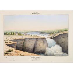
Southern - Concan.. - The falls of Gokank..
Hand colored lithography representing a view of the Gokak Falls, located on the Ghataprabha River. The Ghataprabha river in India is an important right-bank tributary of ...
Date: Paris, 1843

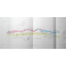
Kaart van een gedeelte van de Noord Kust van Java en Straat Sunda van Tanjong Kaik tot den vierden hoek bij Anjer..
Very large and rare chart depicting Java's northern seacoast.Coastal profiles are present at the bottom of the map.The chart is prepared by B.H.Staring, J.A.G.Rietveld an...
Date: Amsterdam 1843-1844
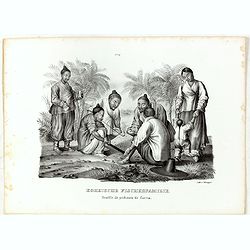
Koreische Fischerfamilie. Famille de pecheurs de Corea.
A Korean family of fishermen playing a board game. No.9' above image. From "Schinz Naturgeschichte und Abbildungen des Menschen der verschiedenen Rassen und Stämme&q...
Date: Zürich, 1845

Straat Sunda en Westkust van Java.
Very large and rare chart depicting Java's western seacoast close to the Sunda Strait.Showing part of Sumatra on top and the West Java tip, today hosting the Ujung Kulon ...
Date: Amsterdam (1841)1846

Kaart van de Reede van Batavia met de verschillende vaarwaters naar dezelve trigometrisch opgenomen op last van deb schout bijnacht E.Lucas.
Very large and rare so-called blue-black chart centered on Jakarta's harbor.The chart is prepared by B.G.Escher, I.A.C. Eschauzier, B.H.Staring and E.H.Boom during an exp...
Date: Amsterdam (1841) 1847

Kaart der Moluksche eilanden en vaarwateren … F.A.A. Gregory Luitenant ter zee …
Huge sailing chart centered on the Moluccas Islands. Published by Widow Gerard Hulst van Keulen.The publishing house van Keulen, were the most prominent chart makers at ...
Date: Amsterdam, 1847
Infanterie Turque (chasseurs). 7 novembre 1837.
Beautiful lithography by Auguste Raffet (1804 -1860 ) and printed by Auguste Bry.
Date: Paris, Gihaut frères, 1848

ARMENIEN. Costumes de l'Empire Ottoman 9.
A beautiful hand colored lithograph of an Armenian published in the French work "Galerie Royale de Costumes peints d´après nature par divers artistes et lithographié...
Date: Paris, Chez Aubert & Cie., 1842-1848
AFGHAN de CABOULE. Costumes Persans 8.
A beautiful hand colored lithograph of an elegant Afghan from Kabul published in the French work "Galerie Royale de Costumes peints d´après nature par divers artiste...
Date: Paris, Chez Aubert & Cie., 1842-1848

DANSEUSE. Costumes Persans 9.
A beautiful hand colored lithograph of an elegant dancing girl from Persia published in the French work "Galerie Royale de Costumes peints d´après nature par divers ...
Date: Paris, Chez Aubert & Cie., 1842-1848
Carte des Détroits Singapore, Durain..
An exceptionally rare nautical chart of Singapore and direct vicinity issued by Urban Dortet de Tessan, under the patronage of Louis Philippe I of France. When Singapore...
Date: Paris, 1848
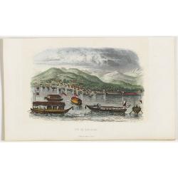
Der Hafen und die Bai von Nagasaki.
A bird's-eye view showing Deshima and Nagasaki Bay with Dutch ships and two Dutch flags on Deshima.
Date: Germany, 1850
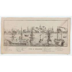
View of Singapore
Very rare view of Singapore from the Singapore River Basin. With a numbered key (1-19) underneath the illustration. In the center Government Hill with Governer's House (1...
Date: ca. 1850

Plan de Constantinople, non compris ses faubourgs. Grave d'apres les documents du ministere de la Guerre par E. Olivier.
A very rare lithographic large-scale town-plan of Istanbul, Scale 98 yards to one inch., printed in Pera, Istanbul by E. Olivier. The ornate design on the top of the t...
Date: Péra, Istanbul, 1851

Simori.
Portrait of Simori.Von Siebold was born in Wurtzburg, in Germany, and worked for the Dutch government as a doctor in Java. In Japan, where Von Siebold arrived in 1823 at ...
Date: Leiden, 1832-1852
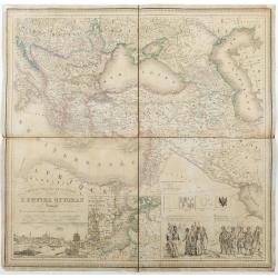
Carte du theatre de la guerre L'Empire Ottoman ..
Very detailed and decorative map of the Ottoman Empire. Lower left a fine panoramic inset (185x80mm) with a view of Istanbul. Next to it a inset map of the Baltic Sea and...
Date: Rouen/ Paris, 1854

Carte d'unne partie de l'Arabie Septentrionale Pour suivre les Voyages de Mr. G.A. Vallin. . .
This is the original hand-drawn map by Victor Adolphe Malte-Brun of "Carte d'unne partie de l'Arabie Septentrionale Pour suivre les Voyages de Mr. G.A. Wallin",...
Date: Paris, November 1855
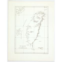
The island of Formosa.
A small, but historically important map of Taiwan (the first American lithograph of Taiwan) made by the American Commodore Matthew C. Perry and published by Ackerman. The...
Date: New York, 1856
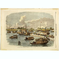
Sick and wounded embarking at Hong-Kong on Board the Steamer.
Large view of the harbour with numerous ships and people. From the Illustrated London News, October 23, 1858.
Date: London, October 1858
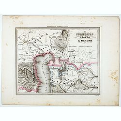
Il Turkestan il Mar d'Aral ed il Mar Caspio.
Uncommon map of Turkestan with the Northern part of the Caspian Sea, with part of present-day Uzbekistan in the lower right corner. in the prepared by Francesco Costanti...
Date: Genova, Paolo Rivara fu Giacomo, 1858

(Untitled view from Scutari with a view of Constantinople)
Panoramic view from Scutari with a view of Constantinople in the distance, after a design by Johann Schranz. Published by J. Missiriè.
Date: Paris, 1860

A fan combining views of Hong Kong (right), Canton (center), and Macau.
The fan shows nice images of Macau, Hong Kong and Canton on onside and on verso a garden with 45 characters welcoming a rider on his white horse. Their clothes are height...
Date: China, ca. 1850-1860

Plan de la rade de Macao (chine) Levé d'après les ordres mr. Rocquemaurel.
Very detailed chart of Macao and several of the surrounding Islands, and features numerous depth soundings throughout. Prepared by captain, Gaston de Rocquemaurel. Logo o...
Date: Paris, c.1856 / 1863

Carte générale de L'Empire Ottoman en Europe et en Asie dressée par Henri Kiepert . . .
Large School wall map of Turkish Empire printed in chromo-lithography. Published by Dieter Reimer and printed by Ferdind Barth in Berlin. This rare map has two insets in ...
Date: Berlin, Verlag von Dietrich Reimer, 1867

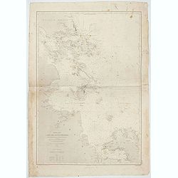
Mer de Chine - Detroit De Singapour Partie Comprise Entre Singaour et Le Dett. De Malacca d'apres les travaux du Commr. J.W. Reed de la Marine Royale d'Angleterr...
Mer de Chine - Detroit De Singapour Partie Comprise Entre Singaour et Le Dett. De Malacca d'apres les travaux du Commr. J.W. Reed de la Marine Royale d'Angleterr, execute...
Date: London, 1871
Mer de Chine - Carte des Iles et Détroits entre Singapoure et le Détroit de Banca. Dréssée d'après le stravaux Anglais et Hollandais plus récents, par Mr. L. Manen . . . 1866
A nautical chart of Singapore and neighboring islands. The first edition of the chart was published in 1866 from French and English sources, this is the corrected version...
Date: London, 1866-1871
TYO SYEN Corée par les Missionnaires de Corée de la société des missions etrangéres.
A very nice map and rare map of Korea. Prepared by R.P.Carceri who was an missioner active for de la Sociéte des Missions Etrangères.Published as a supplement to Journal ...
Date: Lyon, 1872
Selling price: ????
Please login to see price!
Sold in 2023

Kiepert's Physikalische Wandkarten IV. ASIEN. . .
Wall map of Asia printed in chromo lithography. Published by "Stich und Druck der lith. Anst. Von Leopold Kraatz in Berlin". Physical map showing the Asian cont...
Date: Berlin, D. Reimer, 1873

Mer de Chine - Detroit De Singapour Partie Comprise Entre Singaour et Le Dett. De Malacca d'apres les travaux du Commr. J.W. Reed de la Marine Royale d'Angleterr, ...
A detailed chart of Singapore Strait, drawn from an English Chart by J.W. Reed, who surveyed Singapore and environs between 1865 and 1869, aboard the H.M.S. Rifleman.The ...
Date: Paris, 1873

Carte du Kouy-Tchéou.
Detailed map of Guizhou Province prepared by Mgr. Faurie and other sources supplied by missionaries. Published in "Les Missions Catholique". Engraved by P. Méa....
Date: Lyon, c.1874
![Carte du Tche-Kiang. [ Zhejiang province ]](/uploads/cache/30921-250x250.jpg)
Carte du Tche-Kiang. [ Zhejiang province ]
Map of Tche Kiang, prepared by Bishop Edmond-François Guierry, C.M. (Vicar Apostolic of Zhejiang, China) after sources supplied by missionaries. Published in "Les Mi...
Date: Paris, 1874

Un Reclutatore in India. Papagallo No. 42. Anno VI.
A British recruter in India. Design by Augusto Grossi. Taken from the Italian satirical newspaper Il Papagallo, a satirical magazine founded in January 1873 by Augusto Gr...
Date: Bologne, 1878
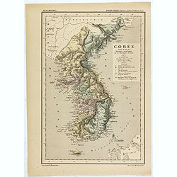
Carte de la Corée d'après la Carte du Dictionnaire coréen-français par les Missionnaires de Corée. . .
Map of Korea called "Corée", which was produced by the French organization Mission Etrangères de Paris (MEP) in 1880. Supposedly, the map was based on Father Ki...
Date: Paris, 1880
(Set of 4 maps) Itinéraire de Pékin à Sartchy
Set of 4 geological maps from the "Nouvelle Archives du Museum" printed by Becquet.1) Route de Pekin a Suen-Hoa-Fou2) Route de Thae-Seu-Tchouang aux tentes mong...
Date: Paris, ca. 1880
![Hong Kong. [Queen's Road]](/uploads/cache/24362-250x250.jpg)
Hong Kong. [Queen's Road]
Finely executed watercolor made by Henri Dieth of a charming atmospheric street scene at Queen's Road in Hong Kong. The watercolor is made after Eduard Hildebrandt (1818-...
Date: Germany, 1882
![Hongkong Piratenstrasse. [Pirate Street]](/uploads/cache/24363-250x250.jpg)
Hongkong Piratenstrasse. [Pirate Street]
Finely executed watercolor made by Henri Dieth of a charming street scene at "Pirate Street" in Hong Kong. The watercolor is made after Eduard Hildebrandt (1818...
Date: Germany, 1882

Runde Strasse in Peking.
Finely executed watercolor made by Henri Dieth of a charming street scene in Peking. The watercolor is made after Eduard Hildebrandt (1818-1869). Hildebrandt, was born in...
Date: Germany, 1882

Kaart van Het Noordelijk Gedeelte Van Het Eiland Borneo.
A very detailed map of Northern Borneo including Brunei, taken from the "Atlas der Nederlandsche bezittingen in Oost-Indië", which was published by Departement ...
Date: The Hague, 1883-1885

Atlas des Missions de la Société des Missions-Étrangères. . .
This scarce atlas contains maps showing the locations of the Catholic missions belonging to the Société des Missions Étrangères in Asia. It covers India, Burma, Siam, Mal...
Date: Lille, 1890
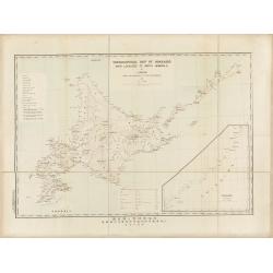
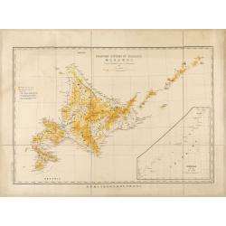
Topographical map of Hokkaido with localities of useful minerals.
Bilingual (English/Japanese) topographic map (1:1,500,000) of Hokkaido Island detailing the distribution of mineral deposits and mining sites (“useful minerals”), publish...
Date: Hokkaidōchō (Gouvernement de Hokkaidō), Sapporo, 1891
Mountain system of Hokkaido.
Bilingual English/Japanese map of Hokkaido showing elevations, volcanoes and roads for geological observations, with an inset of Chishima (Kuril Islands).
Date: Hokkaidōchō (Gouvernement de Hokkaidō), Sapporo, 1892

Chosen Danpan - Korean negotiation.
A scene of a Japanese legation under the command of Hanabusa Yoshitada who is forcing the Korean King Kojong (1852-1919) to agree to Japanese demands during the Chemulpo ...
Date: August 8, MEIJI 27th year or 1894

KOUSHI NYUJO no Zu - HANABUSA Legation enters in Palace, Seoul.
A scene of Japanese legation HANABUSA who are entering the Royal Palace, Seoul.
Date: August 8, MEIJI 27th year or 1894
![[Europe].](/uploads/cache/46155-250x250.jpg)
[Europe].
A detailed map from Учебный Географический Атлас published by the very successful St. Petersburg publisher "Cartographic institution A.Ilina" ("Картографич...
Date: St. Petersburg, 1899
![[Asia].](/uploads/cache/46172-250x250.jpg)
[Asia].
A detailed map from Учебный Географический Атлас published by the very successful St. Petersburg publisher "Cartographic institution A.Ilina" ("Картографич...
Date: St. Petersburg, 1899
![Nankin [Nanjing, Jiangsu]](/uploads/cache/30031-250x250.jpg)
Nankin [Nanjing, Jiangsu]
Very detailed (1:1.000.000) map showing the area north of Nanjing, Jiangsu. The French Service géographique des armées was founded in 1887 and provided the French militar...
Date: Paris, 1900

COLLECTION OF HONG KONG MAPS, BOOKS & FLYERS. Including CHINA - HONGKONG surveyed by Captn. Sir Edward Belcher, in H.M.S. Sulphur 1841. Corrected to 1901.
A collection of 30 maps, prints, and publications relating to Hong Kong. Including : - BELCHER, E. Sir, An updated version of this most important nautical chart of Hong K...
Date: London, 1841 - 1901

CANTON Kong-Teheou.
Very detailed (1:1.000.000) map centered on Macao and Victoria Island, showing soundings, English, Australian, Danish telegraph lines reaching Hong Kong and extended to M...
Date: Paris, 1898 updated for june 1904
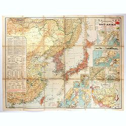
Übersichtskarte von Ost-Asien im Maßstabe 1: 5.000.000 mit 14 Beikarten in großen Maßstäben . . .
A large, uncommon map of East Asia prepared by Karl Peucker, and published by Ataria & Co. Striking and heavily annotated with information on China, Korea, Japan, and...
Date: Vienna, Artaria, 1904
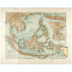
Hinterindien und Malayischer Archipel.
Map of South East Asia with four insets. Shows settlements, roads, railways, telegraph cables, etc. A color key to Dutch, French, British, and Portuguese occupations. Inc...
Date: Leipzig, 1905
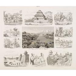
![Manila the perl of the Orient. Guide book to the intending visitor [with several photos and 3 plans of Manila]](/uploads/cache/48356-250x250.jpg)
Manila the perl of the Orient. Guide book to the intending visitor [with several photos and 3 plans of Manila]
Charming 1908 Guide book to with several photos and 3 folding plans of Manilla. Published by the "Manila merchants' association", directed by O'Connell, Daniel....
Date: Manilla, 1908
