Browse Listings in Asia
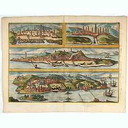
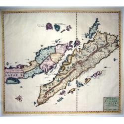
Casablanca (Anfa) - Azemmour (Azamor) - Diu - Old Goa (Velha Goa)
Four fine coastal views of these harbors cities which were important to Portuguese trade. Goa and Diu on the western coast of India, together with Anfa (Casablanc) and Az...
Starting Bid: $240
BidAsk spread: $240 - $450
Maker: BRAUN, G. / HOGENBERG, F.Date: Cologne, 1618
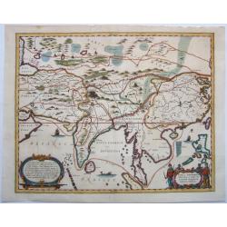
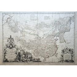
China, Historic travel routes to,- TABULA GEODOBORICA Itinerum a variis in CATAIUM susceptorum rationum exhibens
Antique copper engraved map of Asia, from Persia to China, illustrating various routes of travel across the continent - Marco Polo, Jesuits, etc. The map was published in...
Starting Bid: $296
BidAsk spread: $370 - $540
Maker: KIRCHER, A.Date: Amsterdam, 1667
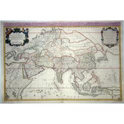
L'ASIE DISTINGUE EN SES PRINCIPALES PARTIES. . .
A first issue of the large and very decorative two-sheet map of Asia by Hubert Jaillot, published in the 'Atlas Nouveau' in 1674, with the related index sheet This import...
Starting Bid: $760
BidAsk spread: $950 - $1400
Maker: JAILLOT, A.-H.Date: Paris, 1674

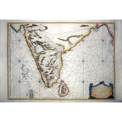
Sinus Gangeticus vulgo Golfo de Bengala Nova descriptio.
Showing the east coast of India and Sri Lanka. West to the top. Decorated with two compass roses, six vessels, a figurative title cartouche and a scale cartouche. The map...
Starting Bid: $200
BidAsk spread: $500 - $500
Maker: JANSSONIUS, J.Date: Amsterdam, 1680
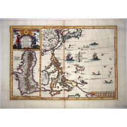
(Philippines),- Nova et Vera Exhibitio Geographica Insularum Marianum cum Insulis de Pais.
The 1702 Scherer Map of the Philippine Islands (Philippines) and Guam. An uncommon and attractive map showing the Philippines, Japan, Korea and Indonesia, with an inset o...
Starting Bid: $600
BidAsk spread: $750 - $1100
Maker: SCHERER, H.Date: Munich, 1702
![[Cyprus], Deserta Aegypti Thebaidies Arabiae Syriae etc. ubi accurate notata sunt loca inhabitata per Sanctos Patres Anachoreatas.](/uploads/cache/85047-250x250.jpg)
[Cyprus], Deserta Aegypti Thebaidies Arabiae Syriae etc. ubi accurate notata sunt loca inhabitata per Sanctos Patres Anachoreatas.
A very decorative and unusual presentation of a reduced version of Michelet's map showing Cyprus, Egypt, and the Levantine coast and hinterland oriented with north to the...
Starting Bid: $240
BidAsk spread: $300 - $430
Maker: SEUTTER, M.Date: Augsburg, ca 1720
(Singapore),- Nieuwe Kaart van het EYLAND SUMATRA. . .
A superb example of Francois Valentijn's 1724 map of Malaya (Malaysia and Singapore) and Sumatra. Oriented to the east, Valentijn's spectacular map covers from the Island...
Starting Bid: $720
BidAsk spread: $900 - $1320
Maker: VALENTIJN, F.Date: Amsterdam, 1724
Alexandri Magni Imperium et Expeditio. . .
The map represents the theatre of Alexander the Great's conquests between the Black Sea and Indus River, today's Turkey, Armenia, Iraq, Iran, Afghanistan, etc. The map is...
Starting Bid: $50
BidAsk spread: $100 - $100
Maker: DEZAUCHE, J.A. / L'ISLE,G. / BUACHEDate: Paris, 1731
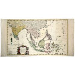
East Indies,-Carte Des Indes Orientales dessinee suivant les Observations les plus recentes dont le principal est tiree des Cartes hydrographiques de Mr. D'Apres de Mannevillette . . .1748
A highly detailed very large map of the region between India and the Philippines, centered on the Malaysian Peninsula. The map extends northwards to China, and it include...
Starting Bid: $464
BidAsk spread: $580 - $850
Maker: HOMANN HEIRSDate: Nuremberg, 1748
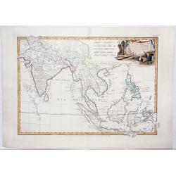
East Indies,- Les Indes Orientales et leur Archipel. . .
A general map of Indonesia, extending from India to the Philippines and New Guinea. With a decorative title cartouche. Boundaries outlined in hand color. From the "...
Starting Bid: $104
BidAsk spread: $130 - $190
Maker: LATTRÉ, J. / BONNE, R.Date: Paris, ca 1762
INDIA,- CARTE REDUITE DE LA PRESQUE ISLE DE L'INDE .. 1766
Striking, extra-large nautical map of India and Sri Lanka, extending from the Bay of Bengal and the mouth of the Ganges to Guzurat, and including a detailed treatment of ...
Starting Bid: $320
BidAsk spread: $400 - $600
Maker: BELLIN, J.N.Date: Paris, 1766
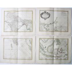
EAST INDIES,- Carte Hydro-geo-graphique des Indes Orientales.. (Set of Four Maps).
A detailed map with a large, and very decorative title cartouche, showing the coast of southern China [incl. the island of Hong Kong, also not labeled], Taiwan and the Ph...
Starting Bid: $360
BidAsk spread: $450 - $650
Maker: BONNE, R.Date: Paris, 1771
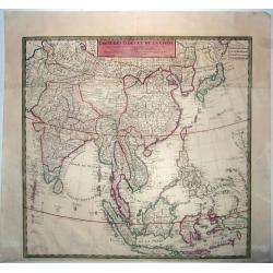
CARTE DES INDES ET DE LA CHINE.
De L’Isle’s detailed and exceptional map of South-East Asia showing both the East Sea and the Sea of Korea. An updated example of this noteworthy map of East Asia and...
Starting Bid: $320
BidAsk spread: $400 - $550
Maker: DE L'ISLE, G. / BUACHE, P. / DEZAUCHE, J. A.Date: Paris, 1781
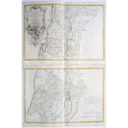
Terrae Sanctae Tabula e Scripturae Sacrae, Flavii Josephi, Eusebii et Divi Hieronymi..Opus posthumus G.DE L'ISLE..
A fine 2 sheet map centered on Palestine on both sides of the Jordan, divided among the Tribes and according to the division into provinces of the Roman time. Very nice ...
Starting Bid: $360
BidAsk spread: $450 - $650
Maker: LATTRÉ, J. / DE L'ISLE, J.N.Date: Paris/ Bordeaux, 1771-1782
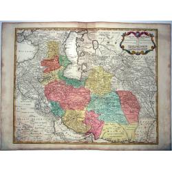
Carte de Perse dressée pour l'usage du Roy.
A large 18th-century map of the Persian region (Iran, Iraq, Afghanistan) with Armenia Georgia, and the Arabian desert by G Delisle. An updated edition by Buache/Dezauche....
Starting Bid: $128
BidAsk spread: $160 - $230
Maker: DE L'ISLE, G.Date: Paris, 1785
Carte la plus generale et qui comprend la Chine, la Tartarie chinoise et le Thibet. . .
With a quite elaborately pictorial cartouche, engraved by G.Kondet. Very detailed map of China, Tibet and Korea. Jean Baptiste Bourguignon d' Anville (1697-1782), French ...
Starting Bid: $2200
BidAsk spread: $2750 - $2700
Maker: D'ANVILLE, J.-B. B.Date: Paris, Dezauche, 1789–1799
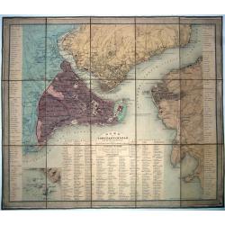
Constantinople, Plan de ..., et de ses faubourgs d'après Kauffer. . . et Joseph de Hammer avec l'indication des quartiers de la ville (Mahalle) et les changements qui s'y sont opérés depuis les années 1776 et 1786. . .
A fine, large, original colored folding map/plan of Constantinople [Istanbul].< Extremely detailed with abundant information on the town, its districts, and suburbs. ...
Starting Bid: $240
BidAsk spread: $300 - $420
Maker: HELLERT, J.-J.Date: Paris, 1836
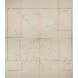
Plan de la rivierè de Saigon et de ses affluents dressé par ordre de M. le capitaine de vaisseau d'Ariès, gouverneur de Saigon, d'après les documents fournis par MM. Lespès. . .
A huge folded map the Saigon river prepared after Léo de Lespès, Rieunier Narac. Inset map of "Carte de Banc de Corail, levée d' après les ordres de Mr. le Capta...
Starting Bid: $400
BidAsk spread: $400 - $750
Maker: DE LESPES, L.Date: St Joseph, Saigon, after 1860
Europish Turkije, Griekenland Jonische Eilander.
Uncommon map of Greece, Lithography by J.H. van Weijer, published in Atlas der geheele Aarde in 24 kaarten. With colored key to processions.
Starting Bid: $10
BidAsk spread: $10 - $10
Maker: SCHOLTENS, A.L.Date: Groningen, ca. 1860
