Browse Listings in Asia
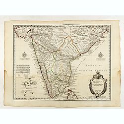
Carte des Cotes de Malabar et de Coromandel..
Detailed and attractive map of India and the northern tip of Sri Lanka. With decorative title cartouche and two compass roses.Rare edition with address : A Paris chez l’A...
Date: Paris, 1723
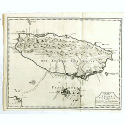
Kaart van het Eyland Formosa en de Eylanden van Piscadores.
The earliest printed map of Taiwan or Formosa. Oriented to the east, with north at the left, covering the entire island and the nearby Pescadores, now known as the Penghu...
Date: Amsterdam, 1724
![[The Philippines]](/uploads/cache/49201-250x250.jpg)
[The Philippines]
Fine chart depicting the Islands of the Philippines. Little interior detail is given but the coastlines, settlements and principal coastal features are identified. An att...
Date: Amsterdam, 1724
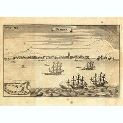
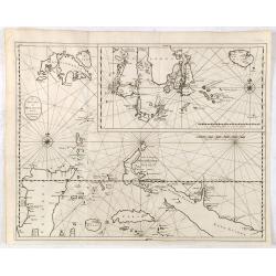
Ormus. (Hormuz)
This very interesting early engraving shows the ships of the Dutchman Van den Broecke, who in December 1628 left his directorship in Surat. Before returning to Batavia he...
Date: Amsterdam, F. Bernard, 1725
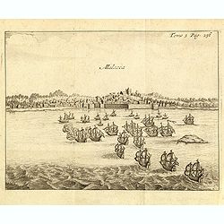
Malacca.
Fine print showing Dutch vessels offshore the city of Malacca, between Singapore to its south and Kuala Lumpur, the capital of Malaysia to its north.From the French reiss...
Date: Amsterdam, J.F. Bernard, 1725
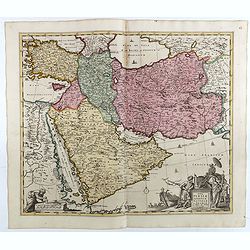
Nova Persiae Armeniae Natoliae et Arabiae.
1725 DE WIT, F. / OTTENS, R. / J. - Shows the Saudi Peninsula and the area east of Cyprus to Iran.
Date: Amsterdam, 1725

Nieuwe kaart van 't Koninckryk Bengale. . .
Rare map Bangladesh with the Ganges delta, including Calcutta. Giving great detail with trade routes, European trade settlements, etc. Prepared by Joh. Van Leenen who was...
Date: Amsterdam, 1726

Nieuwe Kaart van het Eyland Sumatra..
Fine chart depicting the Island of Sumatra and the southern coasts of Malaysia from Quedo to Johore. North is orientated to the left of the page. Singapore is probably id...
Date: Amsterdam, 1726
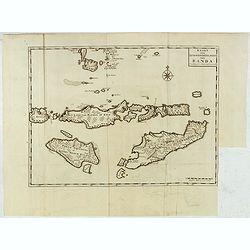
Kaart van de Zuyd-Wester Eylanden van Banda.
Early and detailed map of the Banda Islands, prepared by François Valentijn (1666–1727), a Dutch missionary who spent years in Amboina and traveled extensively through VO...
Date: Amsterdam, 1726

Nieuwe Caart der Eylanden van Banda.
Decorative map of the Banda Islands. Until the mid-19th century the Banda Islands were the world's only source of the spices nutmeg and mace, produced from the nutmeg tre...
Date: Amsterdam, 1726

Die Insel Formosa neu abgemessen auf Befehl Kaysers Kamhi.
One of the earliest obtainable printed maps of Taiwan or Formosa Island. It was issued around 1726 to illustrate Joseph Stöcklein's [Stoecklein] compilation of Jesuit mis...
Date: Augsburg, 1726
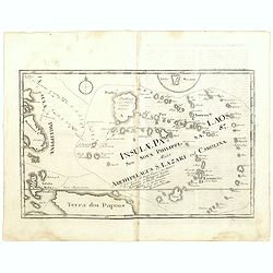
Insulae Palaos seu Novae Philippinae 87 Alias Archipelagus S. Lazari ven Carolinae . . .
Map of Philippine archipelago. Stöcklein's work is a compound of letters of the Jesuit missionaries from all over the world and here particularly the ones stationed at th...
Date: Augsburg, 1726
De Landvoogdy der Moluccos met de Aangrenzende Eylanden . . .
Two charts on one sheet depicting the Moluccas islands. Little interior detail is given but the coastlines, settlements and principal coastal features are identified. To ...
Date: Amsterdam, 1726
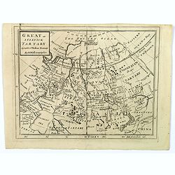
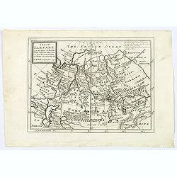
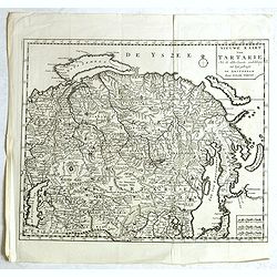
Great or Asiatick Tartary, Agreeable to Modern History.
A map from the Frozen Ocean in the north to Usbec Tartary in the south, from Moscow in the west to China Tartary and Peking in the east. Rivers and mountains feature prom...
Date: London, ca. 1727

Great or Asiatick Tartary, Agreable to Modern History.
Map of Tartary to Peking. The eastern coastline of Asia is almost flat, with no attempt to mark Kamchatka. The Caspian Sea in the lower left, with present-day Uzbekistan ...
Date: London, 1727

Carte nouvelle des Terres de Cucan..
Prepared by H.Reland (1676-1718) a professor active in Utrecht and specialized in Asian languages, geography and religions. His first map was a map of Japan copied after ...
Date: The Hague, 1728

Habillement de l'Empereur de la Chine & des Dames de son Palais..
This impressive engraving is a wonderful example of Chatelain’s elegant plates.Divided in 3 panels, showing examples of costumes of Chinese ladies and those of the king o...
Date: Amsterdam, ca. 1728
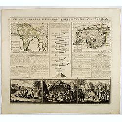
Genealogie des empereurs Mogols . . .
Text sheet with two inset maps of "Carte de l'empire du grand Mogol (122x158mm.) and inset map of Kahsmire "carte nouvelle du royaume de Kachemire" (120x15...
Date: Amsterdam, 1728

L'Inde de la le Gange, suivant les nouvelles observations...
Uncommon edition of this map of Malaysia, Thailand, Indo China and the Northern parts of the islands of Sumatra and Borneo. Singapore marked as Sincapour. With decorative...
Date: Amsterdam, 1728

L'Asie suivant les nouvelles observations...
Uncommon edition of this map of Asia. From Le Nouveau Theatre du Monde, ou la Geographie Royale.The map is of interest for the use of Mer Orientale, the sea between Kore...
Date: Amsterdam, 1728
De Reede en stadt Batavia is geleegen aan de Noord Kust…
A chart of the bay of Batavia with in lower left corner a plan of Batavia (120x147mm). This very rare and influential chart gives a fine representation of Batavia, now kn...
Date: Amsterdam, 1728

Histoire Naturelle, Civile, Et Ecclésiastique..'
First French edition, published by P. Gosse, J. Neaulme and B. Lakeman. The basic work on Japan from the second half of the 17th century when it was still forbidden for f...
Date: Amsterdam, 1729
Historic Map - Naaukeurige Kaart Van Tartaryen, Soo als dat door W De Rubruquis doorreyst.
This attractive map published by Pieter van der Aa, shows Tartary abd the ancient Silk Road region. The map shows the track of William of Rubruck (Willem van Rubroeck or ...
Date: Amsterdam, 1713-1729

Insularum Moluccarum Nova description.
Exquisite map of the famous Spice Islands based. This map was the first large-scale map of the region and depicts the islands which provided first the Portuguese and then...
Date: Amsterdam, 1730
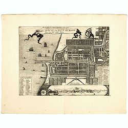
Plan de la Ville et du Chateau de Batavia en l'Isle de Iava / Ware affbeeldinge wegens het Casteel ende Stadt Batavia gelegen opt groot Eylant Java.
Detailed East oriented plan of Jakarta former Batavia on Java / Indonesia. With bird eye view from sea side, various ships and a lion. Two inset keys with detailed descri...
Date: Leiden, 1730
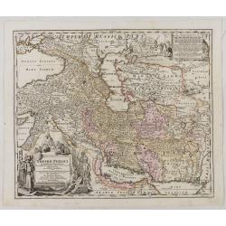
Imperii Persici in omnes suas Provincias . . . Exacte Divisi Nova Tabula Geographica. . .
Showing the eastern part of Turkey and Cyprus, Palestine, Persian Gulf, including Gulf of Oman, Caspian Sea, Iran and the north-west territories of India.Embellished with...
Date: Ausburg, 1730
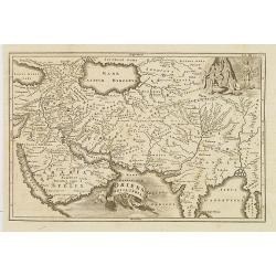
Oriens, Persia, India etc.
Uncommon map of Persia, Armenia, Arabian Peninsular and part of India. Prepared by Christoph Cellarius (1638-1707). From Geographia Antiqua...
Date: Leipzig, Gledisch, 1732

Vorstellung der Evangelisch-Ostindischen Kirche Augsburger Protestanten.
It is a very decorative and rare print to commemorate the 200-year Confession of the Augsburg Protestant Confession. Engraved by J. Kleinschmidt after a design of E. Ridi...
Date: Augsburg, 1732
Great Tartary, with the tract of the Moscovite Ambassador's Travels from Moscow to Pekin in China.
An interesting map illustrating the route taken by the Russian Ambassador on his travels east to Beijing. Shows the Great Wall, "Somer Houses" and "parts u...
Date: London, 1732

Der Hollaendisch-Ostindianischen Compagnie Weltberühmte Haupt - Handels und Niederlags stadt BATAVIA..
Very fine decorative plan of Batavia showing the City and its immediate environs, the surrounding rice fields intersected by a network of waterways, canals and outlying f...
Date: Nuremberg, 1733

Hedendaegsche Historie of tegenwoordige staet van alle volkeren 1 deel. (Volume 1 - China, Japan, Phillippines, Moluccas)
This provides an interesting illustrated description of China, Japan, the Phillippines, Moluccas. Including a map of China, Korea, and Japan, with the Sea between Korea a...
Date: Amsterdam, 1734
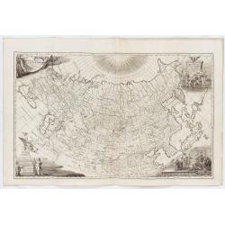
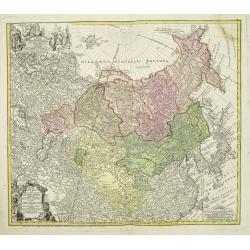
Imperii Russici tabula generalis quo ad fieri potuit / accuratissime descripta opera et studio Ioannis Kyrilow, …
General 1734 large-format map of the Russian Empire compiled by Ivan Kirilov (1689/1695]-1737), the Chief Secretary of the Governing Senate in St. Petersburg in 1734. Th...
Date: Saint Petersburg : [Academy of Sciences], 1734
Selling price: ????
Please login to see price!
Sold in 2025
Description geographique, historique, chronologique, politique, et physique de l'empire de la Chine et de la Tartarie chinoise.
First edition of this cornerstone of any collection of books on China, which is also among the rarest and most desirable of important Americana, included in Rare American...
Date: Paris, P. G. Le Mercier, 1735
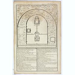
Plan du Tien-tang ou du temple, où l'empereur sacrifie à Chang-ti sous le titre de souverain seigneur de la terre.
Nice example of d'Anville's plan of Tien-tang temple, from "Atlas général de la Chine..."" prepared by Jesuit missionaries and commissioned by Emperor Kang...
Date: Paris, P.G. Le Mercier, 1735
Nova Maris Caspii et Regions Usbeck. . .
This is the first printed map specifically of the Uzbek region. It shows the area around the Caspian Sea and northern Iran. The area eastward from the Caspian is marked '...
Date: Nuremberg, 1735

Description geographique, historique, chronologique, politique, et physique de l'empire de la Chine et de la Tartarie chinoise . . . du Thibet, & de la Coree. . .
Without the separately published atlas. Lacking 2 plates in vol.2 (Obseques at p.149 and Gin seng at p.180), one plate torn without a loss (vol.1, p.230), d4 vol.1 with a...
Date: The Hague, H. Scheurleer, 1736

Asia By H.Moll Geographer.
Detailed map of Asia. From his "Atlas minor: or a new and curious set of sixty-two maps. . .", which was first published in 1729 and reprinted in 1732, 1736.The...
Date: London, 1736

Carte la plus generale et qui comprend la Chine, la Tartarie chinoise et le Thibet. . .
It has a quite elaborate pictorial cartouche engraved by G. Kondet. It is a very detailed map of China, Tibet, and Korea.In the upper left corner is very good details of ...
Date: The Hague, 1737

Royaume de Corée.
With a quite elaborately pictorial cartouche, engraved by G.Kondet. One of the earliest separate maps of Korea. Jean Baptiste Bourguignon d' Anville (1697-1782), French c...
Date: The Hague, 1737
![Province de Fo-Kien. [Includes West Coast of Taiwan]](/uploads/cache/43503-250x250.jpg)
Province de Fo-Kien. [Includes West Coast of Taiwan]
An important map of Fujian Province shows the East Coast of China and the West Coast of Taiwan. It shows that for the Manchu Qing, only the western half of Formosa was co...
Date: The Hague, H. Scheurleer, 1737

Nouvel atlas de la Chine, de la Tartarie chinoise, et du Thibet.
First edition of "the principal cartographic authority on China during the 18th century". It was the second major atlas of China produced in Europe following th...
Date: The Hague, H. Scheurleer, 1737

'T Eilandje Desima verblyf plaats der Hollanders in Japan.
Bird's-eye view of Dejima copied from a manuscript by Voogt, who was second-in-command on Deshima in 1713. The island is viewed from the landside, depicting the developme...
Date: Amsterdam, 1739
Imperii Russici et Tartariae Universae tam majoris Afiaticæ quam minoris et EuropæTabula.
The map is of interest for the use of East Sea, the sea between Korea and Japan, here called "Mere Orientale Minus".Decorative map covering Russia, Tibet, China...
Date: Nuremberg, 1739
Grande Tartarie.
A very nice small map of Central Asia extending from the Caspian Sea to the Pacific Ocean. From Francisco Giustiniani for El Atlas abreviado o el nuevo compendio de la Ge...
Date: Leon de Francia (Lyon), Jaime Certa, 1739
Mogol.
A very nice map of Northern India and Pakistan. From Francisco Giustiniani for El Atlas abreviado o el nuevo compendio de la Geografia universal, politica, historica, i c...
Date: Leon de Francia (Lyon), Jaime Certa, 1739
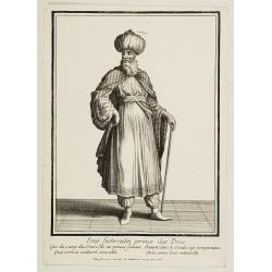
Emir Fechrredin prince des Drus.
Engraving published by Nicolas Bonnart (c.1637 - 1718), engraver in Augsburg since 1719. Before the nineteenth century, portraits of rulers in the Middle East were a rari...
Date: Paris, ca. 1740

Nuova carta dell' Imperio della Chia e dei Paesi circonvicini. / Nueva carta de l'Impario de la Quina.
The map is of interest for the use of Mar di Corea" and "Mar Setentrionale del Giapone" in the sea between Korea and Japan.Rare early edition of Albrizzi's...
Date: Venice, 1740
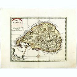
Isola Ceilon.
Attractive copper engraved map of Sri Lanka showing mountains, Towns and the Rama's Bridge (Ponte di Adamo). Included in "Atlante Novissimo che Contiene Tutte le Par...
Date: Venice, 1740
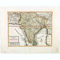
Impero del Gran Mogol.
Attractive copper engraved map of India with Sri Lanka. Showing mountains, towns and the Rama's Bridge (Ponte di Adamo). Included in "Atlante Novissimo che Contiene ...
Date: Venice, 1740

Kaartje van Asia. . .
Attractive and rare map of Asia. From Atlas Portatif . With a curious and oversized Hokkaido. The map is of interest for the use of Corease Zee for the sea between Korea ...
Date: Deventer, 1742

Kaartje van Asia. . .
Attractive and rare map of Asia. From Atlas Portatif . With a curious and oversized Hokkaido. The map is of interest for the use of Coreanse Zee for the sea between Korea...
Date: Deventer 1742

Allerneuester geographisch- und topographischer Schau-Platz von Africa und Ost-Indien. . .
An early issue of this important book by Johann Wolfgang Heydt's describing the Dutch factories, settlements and stations at the hands of the Dutch East India Company in ...
Date: Wilhermsdorf, Tetscher u. Nürnberg, Homanns Erben, 1744

Asia secundum legitimas projectionis stereographicae.
Highlighted area covers part of Spain, eastern coast of Ireland to western part of Papua New Guinea and the Asian continent from the Northern Polar Sea to the Indian Ocea...
Date: Nurenberg, 1744
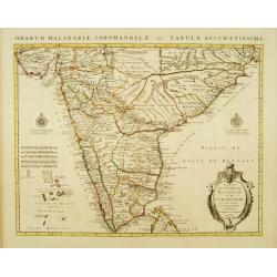
Carte des Côtes de Malabar et de Coromandel Presentée au Roy. . .
Large and attractive map of the Indian coasts of Malabar and Coromandel, embellished with title cartouche and 2 compass roses. It shows the most northern part of Ceylon.T...
Date: Amsterdam c. 1745
![Carte de la coste orientale de la Chine depuis Amoy, jusqu'à Chusan avec une partie de l'Isle Formose [with] Plan du port d'Amoy ou Emouy.](/uploads/cache/33583-250x250.jpg)
Carte de la coste orientale de la Chine depuis Amoy, jusqu'à Chusan avec une partie de l'Isle Formose [with] Plan du port d'Amoy ou Emouy.
Important French chart of the China Sea with the coast of Northern China, including a large depiction of Formosa.Latitude and longitude scales, compass rose and system of...
Date: Paris, Jean-François Robustel, 1745

Nouvelle carte des mers comprises entre le détroit de Banca et P°. Timon avec la partie orientale du détroit de Malacca.
Important French chart of the tip of Malaysia with Singapore. Latitude and longitude scales, compass rose and system of rhumb lines, soundings near coast and in bay areas...
Date: Paris, 1745

A view of the town and castle of Macao.
A nice engraving that shows the attack of the English ship "Centurion" on Macau, during which she captured a Portuguese ship that had sailed from Manila. In upp...
Date: London, 1746
Tabula chronologica historiae Sinicae connexa cum cyclo qui vulgo Kia Tse dictur.
A set of two sheets of colored copper engravings. First published in 1729 in Rome in three sheets. Timeline of China's history with a chronological overview of the dynast...
Date: Augsburg, 1746
A new & accurate map of Asia drawn from actual surveys. . .
An excellent early engraving of Asia. Curious shape for Japan, with a large island north called Yeso and a coastline marked De Gamma's Land. Numbered "No 52."; ...
Date: London, 1747
Selling price: ????
Please login to see price!
Sold in 2024
A New and Accurate Map of the Whole Russian Empire as contained both in Europe and Asia. . .
Detailed map of Russia, from the Sea of Anadyr, Sea of Kamchatka and the Kuril Islands to St.Petersburg. Also includes Tibet, Korea and part of China, with the Great Wal...
Date: London, c. 1747
A map of Quan-Tong or Lyau-Tong province, and the kingdom of Kau-Li or Korea . . .
Detailed map of Korea, Liaodong, and the tip of Shandong Province prepared by Thomas Kitchin for Thomas Salmon's Universal Traveller, based on D'Anville's landmark map of...
Date: London, 1747

Le Japon.
The map is of interest for the use of Mer de Corée, for the sea between Korea and Japan. Small detailed map of Japan and Korea. Dated 1749. A note next to island "...
Date: Paris, 1749

L'Arabie.
Small detailed map of the Arabian Peninsula. From Atlas Portatif Universel, by Robert de Vaugondy.Page 162 outside border top right.
Date: Paris, later than 1749
![Kantong [The Dutch Folly Fort off Canton]](/uploads/cache/05714-250x250.jpg)
Kantong [The Dutch Folly Fort off Canton]
Charming 18th water color on paper depicting The Dutch "Folly Fort" off Canton. Probably made by a western artist visiting China.Forts were built in several pla...
Date: Canton?, c.1750

Carte du Katay, ou Empire de Kin : pour servir a l'Histoire de Jenghiz Khan, raportée dans l'Histoire generale des voyages, tirée de l'Angloise.
The map is of interest for the use of East Sea, the sea between Korea and Japan, here called "Mer de Corée".Fine map of Korea and China's Yellow Sea. Complete t...
Date: Paris, 1750
Selling price: ????
Please login to see price!
Sold in 2023

Vue de L'Hotel de Batavie. . .
A so-called optical print of Fatahillah Square in Jakarta, Indonesia, prepared for use in a light-box or an amusing light-show. This richly hand colored print is much per...
Date: Augsburg, 1750

Cochin (today: Ernakulam)
Small but charming 18th water color on paper depicting Cochin (today : Ernakulam) was from 1500, when the first Portuguese fleet called on its port, a firm ally of the Po...
Date: India? c.1750

Kancheu.
Charming 18th water color on paper depicting Kancheu. Probably made by a western artist visiting China.
Date: c.1750
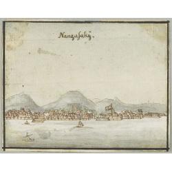
Nangasakij.
Charming 18th watercolor on paper depicting a panoramic view of Nagasaki and the factory Deshima of the V.OC. Probably made by a Western artist visiting Japan.RARE. Due ...
Date: c.1750

Tschanibei Ally Bassa. Türckischer Gross-Böthschafter um Kayserl.
Engraving by Johann Martin Bernigeroth (1713-1767) showing a full portrait of the Turkish ambassador in Vienna Ally Bassa.
Date: Leipzig, c. 1750

L'Empire de la Chine. . .
Detailed map of China, Korea and Taiwan. The large title cartouche is resplendent in the French style with musicians, a dancer, and various accouterments representative o...
Date: Paris, dated 1750

Carte du Katay ou Empire de Kin. . .
The map is of interest for the use of Mer de Corée for the sea between Korea and Japan. Fine map of Korea and China's Yellow Sea. Complete title in top: Carte du Katay ou...
Date: Paris, 1750

Karte von Katay od. dem Reiche Kin, zur Geschichte von Jenghiz Khan. Aus dem Englischen.
The map is of interest for the use of East Sea, the sea between Korea and Japan, here called "Meer von Corea".Copper engraving, hand colored in outline and wash...
Date: Leipzig, Schwabe, ca. 1750
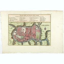
Plan de la ville de Siam.
Early plan of Siam, Thailand. Across the top is an extensive list of 22 important sites and locations keyed to the plan with tiny letters and numbers.Jacques Nicolaas Bel...
Date: Paris, 1750
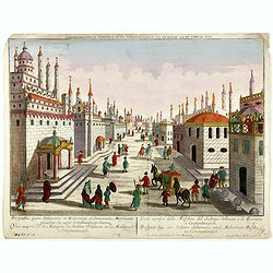
Prospectus, quem Solimanni et Mohameti. . . - Vue aupres de la Mosquee du Sultan Soliman, et de Mohamet . . .
Imaginary view inside Istanbul showing Sultan Soliman in his carriage , a so-called optical print.
Date: Augsburg 1750
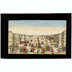
Imaginary view of a square with Muslims festival.
Imaginary view of a square with Muslims festival. A so called optical print.
Date: Paris, ca. 1750
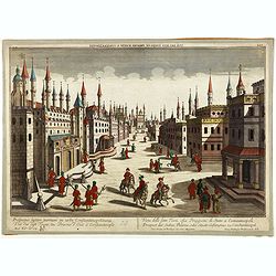
Prospectus septem turrium in urbe Constantinopolitana / Vüe des sept Tours ou Prisons d'etat à Constantinople. . .
Imaginary view inside Istanbul showing the State prison, the seven towers to Constantinople, a so-called optical print.
Date: Augsburg 1750

Carte de L'Isle de Sumatra Dressee sur les Journaux des Navigateurs . . .
Detailed map of Sumatra and Malacca, centered on Singapore and including the southern portion of the Malaysian peninsula. With "Detroit de Sincapour" and severa...
Date: Paris, ca. 1750
Nieuwe kaart van Tartarie. . .
A map of Tartary, Korea and part of Japan. Map place names in Korea are marked. The map is most notable for the confusion between Kamchatka and Jesso.The Caspian Sea in t...
Date: Amsterdam, 1731 / 1750

The East Part of India, or India beyond the R. Ganges.
Herman Moll's map of those Asian countries to be found east of the River Ganges, including Burma, Thailand, Vietnam, Laos, Cambodia, southern most China, Malaysia, Sumatr...
Date: London, ca 1750
