Subscribe to be notified if similar examples become available.
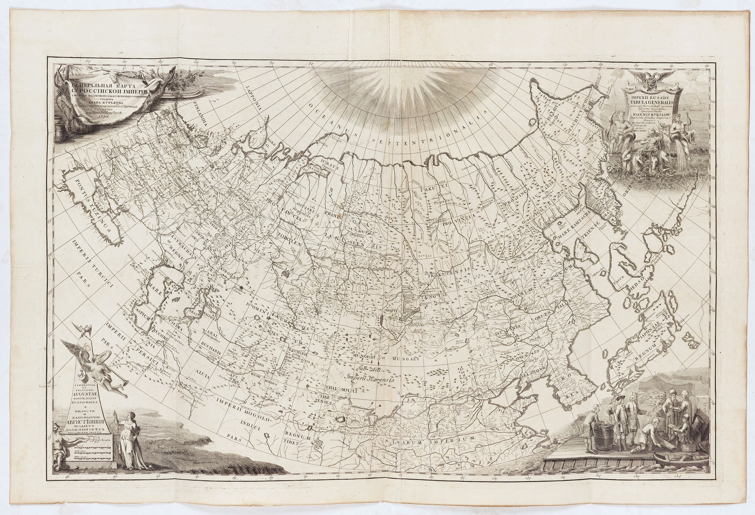
Imperii Russici tabula generalis quo ad fieri potuit / accuratissime descripta opera et studio Ioannis Kyrilow, … |
||||||||||||||||||||
|
||||||||||||||||||||
|
|
||||||||||||||||||||
|
|
My Collection +
Add this or any of your favorite items in one place. If you want to save the items permanently, you have to sign in or create an account first. |
|||||||||||||||||||
Description
General 1734 large-format map of the Russian Empire compiled by Ivan Kirilov (1689/1695]-1737), the Chief Secretary of the Governing Senate in St. Petersburg in 1734. This is the first general map of the state to be created in Russia on a scientific basis. It utilizes a system of astronomical reference points, a grid of conic projection, the latest expedition data, and materials from the first instrumental surveys of the country's individual territories.
A cartouche with the title contains a fragment of the procession of Neptune, allegorical images of rivers, a two-headed eagle with a broadsword and a cross, and an armillary sphere. The figure on the lower right side shows the trading scene with the aborigines. In the background, fishing tackle and fish are displayed. Some good detail in Uzbekistan.
The mapping was carried out in special state departments. The Geographical Department of the Petersburg Academy of Sciences and the Geographical Department of the Cabinet of His Imperial Majesty issued general maps not only in Russian but also in Latin and French because European states and Russia mutually interested in disseminating information about their territory.
The map shows the boundaries of states and individual territories, administrative boundaries within the Russian Empire; administrative centers, other cities and settlements; hydrography; relief; and vegetation. The water resources are most accurately depicted, including rivers, lakes (sometimes with an indication of water quality), and even excavated tanks and wells are marked in drylands. The thematic elements are also widely represented: military and economic objects (fortresses, redoubts, sentries, defensive lines, factories); the settlement of the indigenous peoples (in the Asian part of the state); territories of nomadic peoples; a variety of historical information (national or personal priority of geographical discoveries, ancient settlements ("ruins"), the Great Wall of China, etc. All thematic information, except clearly localized objects, is represented in the form of inscriptions.
Much attention was paid to the map's decoration. The thematic cartouches and drawings glorified Russia's military and economic power; glorified the reigning persons; reminded of historical events; told about economic activity and scientific research and showed the arms of provinces, governorships, and cities.
It is the first printed map to show the cartographic results of Vitus Bering's First Kamchatka Expedition (1727 - 1730) and the first appearance of any part of Alaska (St. Lawrence Island) on a printed map. The map's coverage extends from the Black Sea to the Bering Strait, and from the North Pole to the Persian Gulf, Korea, Japan, and the Yangze River.
Decorative cartouche work adorns all four corners, underscoring the Tzardom's wealth and power.
This is the first published scientific map of the Russian Empire. A new comprehensive survey of the Russian Empire was ordered by Peter the Great in 1721. Ivan Kirilov, an accomplished surveyor with the Senate Chancellery, was assigned to the complex task of compiling explorers' data and newly commissioned local surveys. According to Bagrow, 'Kirilov was one of the most enlightened Russians of the early eighteenth century' and 'one of the first of Russian map-makers to apply Western-European methods of cartography.'
Bagrow writes, 'the general map of Russia … while not giving very many details, is yet the earliest map that presents Russia as a whole on more or less accurate lines, together with her seacoasts and network of rivers.
This map was compiled by Ivan Kirilov and published in Petropoli, Russia, as part of Kirilov's Atlas Imperii Russici. After Kirilov's death, most of his map plates and existing copies of his atlas were acquired by the St. Petersburg Academy of Sciences and suppressed, as the academy was at the time compiling its own competing atlas (issued 1745). As a result, all examples of Kirilov's work are extremely rare.
According to map historian Leo Bagrow, there are only two complete surviving examples of his atlas, at the Moscow State Archives and the the Ecclesiastical Seminary at Irkutsk.
Based upon their representation in institutional collections, is sure that some of his maps, like the present map of Russia, were initially printed in greater quantities and disseminated as separate issues.
Examples of this map are exceedingly scarce.
FAQ - Guarantee - Shipping
Buying in the BuyNow Gallery
This item is available for immediate purchase when a "Add to Cart" or "Inquire Now" button is shown.
Items are sold in the EU margin scheme
Payments are accepted in Euros or US Dollars.
Authenticity Guarantee
 We provide professional descriptions, condition report (based on 45 years experience in the map business)
Paulus Swaen warrants the authenticity of our items and a certificate of authenticity is provided for each acquired lot.
Condition and Coloring
We indicate the condition of each item and use our unnique HiBCoR grading system in which four key items determine a map's value: Historical Importance, Beauty, Condition/Coloring and Rarity.
Color Key
We offer many maps in their original black and white condition. We do not systematically color-up maps to make them more sellable to the general public or buyer.
Copper engraved or wood block maps are always hand colored. Maps were initially colored for aesthetic reasons and to improve readability. Nowadays, it is becoming a challenge to find maps in their original colors and are therefor more valuable.
We use the following color keys in our catalog:
Original colors; mean that the colors have been applied around the time the map was issued.
Original o/l colors; means the map has only the borders colored at the time of publication.
Colored; If the colors are applied recently or at the end of the 20th century.
Read more about coloring of maps [+]
Shipping fee
A flat shipping fee of $ 30 is added to each shipment by DHL within Europe and North America. This covers : International Priority shipping, Packing and Insurance (up to the invoice amount).
Shipments to Asia are $ 40 and rest of the world $50
We charge only one shipping fee when you have been successful on multiple items or when you want to combine gallery and auction purchases.
Read more about invoicing and shipping
FAQ
Please have a look for more information about buying in the BuyNow gallery
Many answers are likely to find in the general help section.
My Collection+
![]()
With My Collection+ you can collect all your favorite items in one place. It is free, and anyone can create his or her virtual collection.
Unless you are logged in, the item is only saved for this session. You have to be registed and logged-in if you want to save this item permanently to My Collection+.
Read More[+]
Register here, it is free and you do not need a credit card.
Add this item to
My Collection+
or click the following link to see My Collection+.
| Digital Image Download | |
|
Paulus Swaen maintains an archive of most of our high-resolution rare maps, prints, posters and medieval manuscript scans. We make them freely available for download and study. Read more about free image download |
Click the image for a free small image download. |
In accordance with the EU Consumer Rights Directive and habitually reside in the European Union you have the right to cancel the contract for the purchase of a lot, without giving any reason.
The cancellation period will expire 14 calendar days from the day after the date on which you or a third party (other than the carrier and indicated by you) acquires, physical possession of the lot. To exercise the right to cancel you must inform Paulus Swaen Inc, of your decision to cancel this contract by a clear statement (e.g. a letter sent by post, or e-mail.
To meet the cancellation deadline, it is sufficient for you to send your communication concerning your exercise of the right to cancel before the cancellation period has expired.
