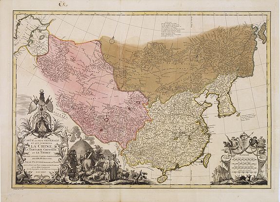
Carte la plus generale et qui comprend la Chine, la Tartarie chinoise et le Thibet. . . |
||||||||||||||||||||
|
||||||||||||||||||||
|
|
||||||||||||||||||||
$2500 / ≈ €2161This item is available for immediate sale! Questions before Buying ?
We are happy to answer your questions.
2500.00
|
My Collection + - Save and collect this or any of your favorite items in one place.
If you want to save the items permanently, please sign in or create account first. |
|||||||||||||||||||
Description
It has a quite elaborate pictorial cartouche engraved by G. Kondet. It is a very detailed map of China, Tibet, and Korea.
In the upper left corner is very good details of towns in modern-day Uzbekistan, Kazakhstan and Turkmenistan. The region here is labeled as "SOGD" and important cities along the Silk Road are mentioned Bokara (Bukhara), Samarcand (Samarkand), etc.
In the west, Thibet and Kashgar are shown, in the north, Mongous, and in the northeast, Mantcheoux. All these areas are now part of modern China, respectively as Tibet, Xinjiang (whose second largest city is Khashgar), Inner Mongolia, and Manchuria (Heilongjiang, Jilin, and Liaoning provinces).
Jean Baptiste Bourguignon d' Anville (1697-1782), was a French cartographer who compiled over 200 maps. This map is from his most important work Nouvel Atlas de la Chine, published in The Hague 1737, The principal cartographic authority on China during the 18th century. (Tooley)
D'Anville used maps prepared by Jesuit missionaries and commissioned by Emporer-Kanyx, who in 1708-1716 ordered a surveying of the country. This map is the first accurate cartographic depiction of this area in the Western world.
The ornate cartouche shows Emperor Kang Hsi presiding over the survey he had ordered the Jesuits to execute in his name between 1708 and 1716. Two fathers, with an armed mounted escort, are investigating a farmer settlement, his lodging and cattle. The scale cartouche is adorned by two wolf hunters.
In the tradition of Sanson and de L'Isle French school of exact cartography, d'Anville brought exacting scholarship and accuracy to his maps. Never leaving Paris, he managed to amass a vast collection of geographical/historical/ statistical/political materials, in particular from the observations of Jesuit missionaries.
He is said to have produced his first map at age 15, but he gained notoriety only in 1735 for his contribution to du Halde's "Description. de la Chine.".
He quickly followed with the 1737 "Nouvel atlas de la chine", and then the 1740 "Atlas general".
FAQ - Guarantee - Shipping
Buying in the BuyNow Gallery
This item is available for immediate purchase when a "Add to Cart" or "Inquire Now" button is shown.
Items are sold in the EU margin scheme
Payments are accepted in Euros or US Dollars.
Authenticity Guarantee
 We provide professional descriptions, condition report (based on 45 years experience in the map business)
Paulus Swaen warrants the authenticity of our items and a certificate of authenticity is provided for each acquired lot.
Condition and Coloring
We indicate the condition of each item and use our unnique HiBCoR grading system in which four key items determine a map's value: Historical Importance, Beauty, Condition/Coloring and Rarity.
Color Key
We offer many maps in their original black and white condition. We do not systematically color-up maps to make them more sellable to the general public or buyer.
Copper engraved or wood block maps are always hand colored. Maps were initially colored for aesthetic reasons and to improve readability. Nowadays, it is becoming a challenge to find maps in their original colors and are therefor more valuable.
We use the following color keys in our catalog:
Original colors; mean that the colors have been applied around the time the map was issued.
Original o/l colors; means the map has only the borders colored at the time of publication.
Colored; If the colors are applied recently or at the end of the 20th century.
Read more about coloring of maps [+]
Shipping fee
A flat shipping fee of $ 30 is added to each shipment by DHL within Europe and North America. This covers : International Priority shipping, Packing and Insurance (up to the invoice amount).
Shipments to Asia are $ 40 and rest of the world $50
We charge only one shipping fee when you have been successful on multiple items or when you want to combine gallery and auction purchases.
Read more about invoicing and shipping
FAQ
Please have a look for more information about buying in the BuyNow gallery
Many answers are likely to find in the general help section.
My Collection+
![]()
With My Collection+ you can collect all your favorite items in one place. It is free, and anyone can create his or her virtual collection.
Unless you are logged in, the item is only saved for this session. You have to be registed and logged-in if you want to save this item permanently to My Collection+.
Read More[+]
Register here, it is free and you do not need a credit card.
Add this item to
My Collection+
or click the following link to see My Collection+.
| Digital Image Download | |
|
Paulus Swaen maintains an archive of most of our high-resolution rare maps, prints, posters and medieval manuscript scans. We make them freely available for download and study. Read more about free image download |
Click the image for a free small image download. |
In accordance with the EU Consumer Rights Directive and habitually reside in the European Union you have the right to cancel the contract for the purchase of a lot, without giving any reason.
The cancellation period will expire 14 calendar days from the day after the date on which you or a third party (other than the carrier and indicated by you) acquires, physical possession of the lot. To exercise the right to cancel you must inform Paulus Swaen Inc, of your decision to cancel this contract by a clear statement (e.g. a letter sent by post, or e-mail (amsterdam@swaen.com).
To meet the cancellation deadline, it is sufficient for you to send your communication concerning your exercise of the right to cancel before the cancellation period has expired.
