Browse Listings in Europe > Netherlands

Sexta Etas Mundi. Folium. CCXVII (dancers of Maastricht).
Latin text page with woodcuts of male Siamese twins, a man headed lion. The large illustration is the only illustration related to the Netherlands : it shows a bridge col...
Date: Nuremberg, 12 July 1493
Selling price: ????
Please login to see price!
Sold in 2024
![[Lot of 25 leaves of France, Brabant, Netherlands, Luxemburg]](/uploads/cache/48264-250x250.jpg)
[Lot of 25 leaves of France, Brabant, Netherlands, Luxemburg]
Twenty-five text leaves with wood block illustrations relating to France, Brabant, the Netherlands, Luxemburg. From the 1552 Latin text edition of Münster's Cosmographia...
Date: Basel, 1552

Slusa, Teutonicae Flandriae opp. . . (Sluis)
Bird'eye view of the town of Sluis.From the greatest publication in this genre!. The Civitates was compiled and written by George Braun, Canon of Cologne Cathedral. Braun...
Date: Cologne, 1580

Descrittione di M. Lodovico Guicciardini patritio Fiorentino, di tutti i Paesi Bassi,...
Second Italian edition (variant B) and first Plantin edition (1st Silvius 1567) and the most sought-after edition of the famous description of the Low Countries, updated ...
Date: Antwerp, Plantin, 1581
![Traiectum ad Mosam. [Maastricht]](/uploads/cache/47901-250x250.jpg)
Traiectum ad Mosam. [Maastricht]
A birds-eye view of Maastricht seen from the south. Rising on Vrijthof square is the dominant complex of Sint-Servaas, in front of which - seen here in a distorted perspe...
Date: Cologne, ca. 1581
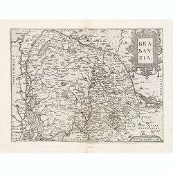
Brabantia.
Map of Brabant from Guicciardini's "Description de touts les Pais-Bais" edited by Plantin in 1582. The map drawn after Ortelius' map of Brabant, and after the l...
Date: Antwerp, 1582

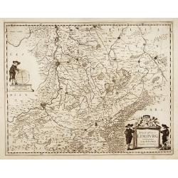
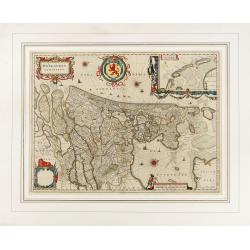
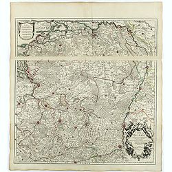
Gelriae, Cliviae, Finitimorumque Locorum Verissima..
East to the top. Fine map of Geldria and Limburg, prepared by Christian s'Grooten. Very fine title cartouche lower right with painter's utensils around the cartouche. ...
Date: Antwerp, 1598

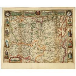
Hollandiae Antiquorum Catthorum..
This map shows Holland in great detail, including small towns, walled cities, rivers and lakes (many of which were reclaimed in the 17th century, and no longer exist). A ...
Date: Antwerp, 1598

Ultrajectum.
An original early 17th century copper engraved miniature antique map of the Dutch province of Utrecht by Petrus Bertius, that was published in Amsterdam at the beginning ...
Date: Amsterdam, 1606

Inferior Germania.
A rare miniature map of present-day The Netherlands and Belgium. Strap-work title cartouche in the lower right corner with scale. Expertly engraved by Petrus Kaerius, the...
Date: Amsterdam, 1606

Die Zyp / La Zype.
A miniature map showing the polder of De Zype. Title cartouche in the upper side.First published in 1598 in his Caert-Thresoor, the plates were executed by the most famou...
Date: Amsterdam / Frankfurt, 1609

Limburgensis Ducatus Tabula Nova.
Map of Limburg, prepared by the Antwerp expert in law and mathematics Aegidius Martini. After 1600 Jan Baptist Vrients acquired the stock and the plates of Ortelius' Thea...
Date: Antwerp, 1606-1612

DELFT. Delphium urbs Hollandiae cultissima. . .
A bird's-eye view of the town of Delft. From the first Dutch translation of Guicciardini's description of the Netherlands. In this town-plan, three buildings, still domin...
Date: Amsterdam, 1612

Ruremunda Gelriae opp.
A bird's eye town-plan of the town of Roermond. From the first Dutch translation of Guicciardini's description of the Netherlands.
Date: Amsterdam, 1612
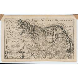
Nova et accurata Foederatarum Orovinciarum Inferioris Germaniae descriptio… 1615 P.Kaerius.
The oldest know map of the Dutch Republik. The extremely rare 1615 edition of the map of the Netherlands. The map is better from from the Cloppenburg editions of the Atl...
Date: J.Janssoius, Arnhem, 1615

Nieuw Nederlandtsch Caertboeck. Waer in volkomentlijcker als oyt te voren vertoont werden de XVII. Nederlanden.
Rare first edition of this atlas of the provinces of the Netherlands, Belgium and Luxemburg. Engraved title page, with : "Gedruckt t' Amsterdam by Abraham Goos Plaet...
Date: Amsterdam, 1616

Frisia occidentalis.
A rare separately published carte-a-figures of Friesland by Geelkercken in its first state. The title and the coats of arms of the eleven Frisian towns appear in the cent...
Date: [Leeuwarden], Dierick Albertsen, 1618

Deliciae Batavicae.
It is a charming book illustrated with portraits of Willem of Orange and Prince Maurits and eight engraved armorial plates. Followed by 30 engraved views or scenes of ...
Date: Amsterdam, Johannes Janssonius, 1618

A new mape of Ye XVII Provinces of Low Germanie.
Showing all 17 Provinces of the Netherlands before the split between Spain and the Protestant Provinces under the House of Orange. The map was published while the war of ...
Date: London, George Humble, 1626 [1627

Kaerte van Bergen op Zoom, Steenbergen ende de nieuwe fortificatien gemaeckt tot bevrÿdinge van 't landt van ter Tolen in tjaar 1628.
Very detailed and scarce map showing Bergen Op Zoom, Steenbergen and its surrounding countryside. North to the left side.
Date: Amsterdam, after 1628

Zelandia Comitatus.
Based on the map by Van Deventer. For the first time a road connection between Flushing, Middelburg and Arnemuiden is shown. Mercator pays much attention to the area of s...
Date: Amsterdam, 1630
Pas-Caert vande ghelegetheyt vande Schans te Santvliet, Vertoonede de verdroncken overwaeterde Landen, nieuw aengewasse gorsingen,. . .
Showing the surrounding countryside of the cities of Antwerp, Santvliet, Lillo, Bergen op zoom, etc. The map is ponctuated by several fortifications to indicate the main ...
Date: Amsterdam, 1630
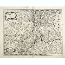
Ducatus Geldriae novissima. . .
Early map of Gelderland, but also including Utrecht, and parts of Brabant. Shows many cities (like Nijmegen, Eindhoven, Zutphen, Zwolle, etc), roads, rivers, woods, regio...
Date: Amsterdam, 1629-1630

Belgii sive Germaniae Inferioris accuratissima tabula.
Very rare and very decorative map with in the right and left borders costumed figures and town plans alternately. In top and bottom border town plans and views.Separate p...
Date: Amsterdam, 1631

Zeelandiae Comitatus.
Rare map of Zeeland, with inset view of the town of Middelburg topped with costumed figures. This is the second edition published by Claes Jansz. Visscher. The first edit...
Date: Amsterdam, 1617-1631

Belgium sive Inferior Germania post omnes..
Early map of the Low Countries, engraved by Abraham Goos and published for the first time in 1618. In the top border town-views of Amsterdam, Dordrecht, Antwerp, and Brus...
Date: Amsterdam, 1618/1631

Episcop. Ultraiectinus.
A very detailed map based on Utrecht. Scale cartouche held by a surveyor. Based on the map by B.F.van Berckenrode (1620-21) and engraved by the master engraver Evert Sijm...
Date: Amsterdam, 1630-1632

Nouvelle et exacte Carte du Duche de Brabant. . .
A very rare example of a map of the Duchy of Brabant. Title cartouche in the lower left-hand corner. A very rare issue of this map of Brabant. Cornelis Danckerts II. copi...
Date: Amsterdam, 1635
Ultraiectum Dominium.
A highly detailed map of Utrecht and its surroundings in the Netherlands.Additional shipping costs apply. The item is located in Schiedam (The Netherlands) and can be s...
Date: Amsterdam, ca 1635
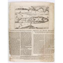
Corte ende waerachtige beschrijvinghe van het Fort de Schencken-Schans. . .
Map of the Schencken-Schans fortress printed with text. Text in Dutch and French.
Date: Antwerp, 1635

Ducatus Limburg.
A very rare issue of this map of Limburg. Cornelis Danckerts II copied the folio map of H.Hondius.The publisher's address was placed in the lower right-hand corner. The c...
Date: Amsterdam, 1636
Ducatus Limburg.
A very rare issue of this map of Limburg. Cornelis Danckerts II. copied the folio map of H.Hondius.The publisher's address was placed in the lower right-hand corner. The ...
Date: Amsterdam, 1636

Amstelodamum, Celebre Emporium Forma Plana.
Second state of this rare and decorative plan of Amsterdam with Visscher's imprint. With a panoramic view seen from the IJ and further insets of Council House, The Exchan...
Date: Amsterdam, c. 1636

Belgium, sive Inferior Germania post omnes…
Third state (only 3 recorded copies) of this scarce map of the 17 Provinces, published by Peter Verbiest in Antwerp. West at top. The maps by Pieter van den Keere in 1607...
Date: Antwerp, 1636

Comitatus Zutphania.
A very detailed map of this area, including Arnhem, Nijmegen, Zutphen, Groenlo, etc. First imprint, from a Latin edition of the scarce Atlas Appendix.
Date: Amsterdam, 1637
Brabantia Ducatus.
Second state of this scarce Carte-a-Figures map of Brabant, published by Peter Verbiest in Antwerp, decorated with three-sided panels. This is the variant without a botto...
Date: Antwerp, 1637

Quarta pars Brabantiae cujus caput Sylvaducis.
A good and dark impression in strong original colors.The third state. The coat of arms of Brabant and 's-Hertogenbosch appears on the map. The municipal arms in the colum...
Date: Amsterdam, 1645

Quarta pars Brabantiae cujus caput Sylvaducis.
A good and dark impression in strong original colors.The third state. The coat of arms of Brabant and 's-Hertogenbosch appears on the map. The municipal arms in the colum...
Date: Amsterdam, 1645

Fossa Sanctae Mariae.
Detailed map of part of the country between rivers Rhine and Meuse showing a canal to be dug between 1626 and 1628 between Rheinberg in Germany and Venlo. A deficiency of...
Date: Amsterdam, 1645

Fossa Sanctae Mariae.
Detailed map of part of the country between rivers Rhine and Meuse showing a canal to be dug between 1626 and 1628 between Rheinberg in Germany and Venlo. A deficiency of...
Date: Amsterdam, 1645

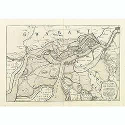
Tabula Bergarum ad Zomam Stenbergae et novorum ibi operum.
The map gives an outline of the Scheldt from Bergen op Zoom to Antwerp, with all the ramparts built between 1622 and 1627.
Date: Amsterdam, 1647

Profil de la renomée ville et port d'Emstredam cappitalle des estats de Hollande.
Extremely rare panoramic town-view of Amsterdam seen from the river IJ.Exceptional bright, sharp example.The print is skillful copy of the print of Matthieu Merian, now w...
Date: Paris, 1647
Hollandia Comitatus.
Orientated west to the top of the sheet, this presents the County of Holland in the classical orientation for seventeenth century maps, with Amsterdam at the center. The ...
Date: Amsterdam, 1647

Currus Veliferi Illmi. Pr. Mauritii Nassouvii. (Prince Maurits' sailing-carriage, designed by Simon Stevin. )
Prince Maurits' sailing carriages had been designed by Simon Stevin. The Prince, always accessible to new inventions of his old instructor, could not please the foreign a...
Date: Amsterdam, 1649
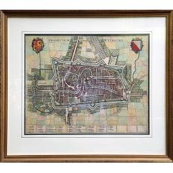
Traiectum Wttrecht
Fine plan of Utrecht from the townbooks "Novum Ac Magnum Theatrum Urbium Belgicae Liberae Ac Foederatae".FRAMED : Additional shipping costs apply. The item is l...
Date: Amsterdam, 1649

Curia Hollandiae Interior. (Binnenhof)
The government center of the Netherlands is situated in and around the Binnenhof-Buitenhof in The Hague. In 1248 the Roman king Willem II built a castle here and named it...
Date: Amsterdam, 1649

De Zype. / Purmer / Wormer/ Beemster / Waterland.
Five maps on one sheet. Showing the polders of De Zype, De Purmer, De Wormer, De Beemster and a map of Waterland, including de Bylmermeer and Monnekedam. Showing the Noor...
Date: Amsterdam, 1652-1658
![De Texel Stroom met de gaten vant Marsdiep. [with] Caarte van De Mase ende het Goereesche Gat.](/uploads/cache/12097-250x250.jpg)
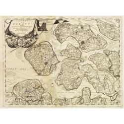
De Texel Stroom met de gaten vant Marsdiep. [with] Caarte van De Mase ende het Goereesche Gat.
Two decorative charts on one sheet, one depicting Texel and the entrance of the Zuider Zee with an inset showing the north coast of West-Friesland, the other depicting th...
Date: Amsterdam, 1660

De Texel Stroom .. vant Marsdiep./ Caarte van De Mase...
Two decorative charts on one sheet, one depicting Texel and the entrance of the Zuider Zee with an inset showing the north coast of West-Friesland, the other depicting th...
Date: Amsterdam, 1660

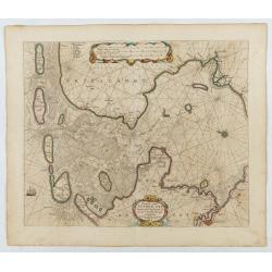
Pascaarte, van de Zuijderzee, Vliestroom, Vlie, en Amelandergat…
Very rare chart of the Dutch Zuiderzee, here in its rare 5th state (o f6). Showing the coastlines along the Dutch inner sea. Two compass roses indicate north to the left ...
Date: Amsterdam, c. 1660

De Tesselstroom met de Gaten van Marsdiep./ De Mase met. . .
Three charts on one sheet depicting the entrances to the Zuiderzee between Holland, Texel and Vlieland. The entrances of the Maas with Rotterdam and in a small inset the ...
Date: Amsterdam, 1662

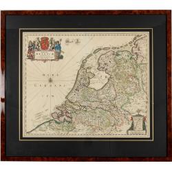
Nova XVII Provinciarum Inferioris Germaniae descriptio .
Extremely rare map of the Benelux by Frederick de Widt. Originally engraved and published by P.Kaerius in 1607. In 1662 the plate came in the possession of Frederick de W...
Date: Amsterdam, 1662

Het West Indisch Huys.
A decorative print of the West Indian House , the headquarters of the WIC, a place for meeting, trading and storage of spices and ship equipment. The maps and charts were...
Date: Amsterdam, J. van Meurs, 1663

Cust van Hollant Tussen de Maes ende Texel.
Uncommon chart of the coast of Holland, including the southern tip of Texel. East at the top. Two fine compass cards, soundings and a large Bree Veerthien offshore.Piete...
Date: Amsterdam, 1666
Pascaart..de Zuyder-Zee, Texel..Vlie-stroom..'t Amelander…
An eye-catching chart of the Zuiderzee with east to the top.Pieter Goos (ca. 1616-1675) was one of the most important cartographer, engraver, publisher and print seller o...
Date: Amsterdam, 1666

Hollandiae pars septentrionalis, Vulgo Westvriesland..
Based on the work of B.F.van Berckenrode, this fine map, orientated west to the top of the sheet, includes Kennemerland and Hollands Noorderkwartier and is a reasonably u...
Date: Amsterdam, ca. 1667

Tabula Ducatus Brabantiae.
Detailed map orientated west to the top.
Date: Amsterdam, 1680
Foederatae Belgicae Tabulae.
Fine, detailed map of the area of the modern Netherlands less the southern part of Limburg, of which the small area around the town of Maastricht is shown in the inset bo...
Date: Amsterdam, 1680

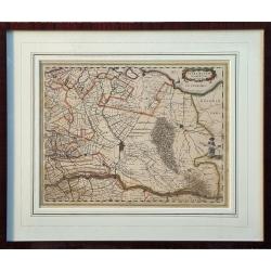
Het Hooge Heemraedtschap van Schielandt.
This beautiful wall map of "Het Hooge Heemraedtschap van Schielandt" is on nine attached leaves (each leaf 49x58,5 cm. ) engraved by J. VINGBOOMS after J.J. STA...
Date: Rotterdam, A. van Hoorn, 1684

Les Provinces des Pays Bas.
RARE. From his first edition of his only folio atlas, the map is relied upon the map of his uncle, Nicolas Sanson. Engraved by I.Somer.A nice map of Netherlands.
Date: Paris 1687

Tabula ducatus Limburch et comitatus Valckenburch. . .
The map describes the southern part of Limburg and reaches into Belgium (Liege, Verviers) and Germany. With two very decorative cartouches.
Date: Amsterdam, 1690
Contado di Zelanda..
A most attractive and decorative map by Vincenzo Coronelli. An elaborate title cartouche garlanded with intertwined flowers and dedicated to Vincenzo Caualli. The remarka...
Date: Venice 1692

Amsterdam Ville du comté de Hollande. . .
A very decorative and very rare town-view of Amsterdam, including a numbered key ( A- T) in the lower part. Engraved by Pierre-Alexandre Aveline. With the signature "...
Date: Paris, ca.1692

Mastric ou Maëstricht, Ville du Brabant-Hollandois. . .
A very decorative and extremely rareof Maastricht, including a numbered key (1-23) in lower part. Engraved by Pierre-Alexandre Aveline. With "Fait par Aveline avec p...
Date: Paris, ca.1692

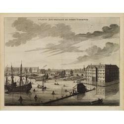
s'Lants Zee-Magazyn en Scheeps Timmer-werf.
Decorative view of the back yard of the formerly the V.O.C. warehouse and arsenal for the Admiralty of Amsterdam, now-a-days the Scheepvaartmuseum (Maritime Museum).The p...
Date: Amsterdam, 1694
s'Lants Zee-Magazyn en Scheeps Timmer-werf.
Decorative view of the back yard formerly the V.O.C. warehouse and arsenal for the Admiralty of Amsterdam, now-a-days the Scheepvaartmuseum (Maritime Museum).The print is...
Date: Amsterdam, 1694

Prospectus Castelli Boxtel.
One of the earliest views of the Castle of Boxtel. Engraved by Henricus Cause. With a description in Latin, French and Dutch.
Date: Amsterdam, 1695

Prospectus veteris castelli Graviae.
One of the earliest views of the ancient Castle of Grave. Engraved by Casper Bouttats. With a description in Latin, French and Dutch.
Date: Amsterdam, 1695
Delfi Batavorum vernacule Delft.
Detailed plan of the city Delft from Frederick de Wit's town book of the Netherlands. The plates are first published by Joan Blaeu one year after the peace of Münster an...
Date: Amsterdam, 1698

Novissima Flandriae Comitatus tabula. . .
Rare issue of Theodorus Danckert's attractive map of eastern Belgium provinces, Flanders, with Brugge, Oostende, Gent, Mons, Antwerp, Cambray, etc..Decorative title carto...
Date: Amsterdam, 1700

Tabula Episcopatuum Leodiensis et Coloniensis. . .
Rare issue of Cornelis Danckert's attractive map of Limburg, shows the area of Cologne, Mainz, Trier, Jülich, Mons, Antwerp and Liege in Belgium.Decorative title cartouc...
Date: Amsterdam, 1700

Oost-Indis Zee Magazyn - Arçenal des Indes Orientalis.
Decorative view of the East Indian Arsenal, now-a-says the Maritime Museum.
Date: Amsterdam, ca. 1700

Arcenal de l'Amirauté.
A decorative print of the 'T Landts Magazyn , or 'Scheepvaart Museum' (Naval Museum).
Date: Amsterdam, ca. 1700

D' Admiralyteyts Huys - La maison de l'Amirauté.
Decorative print of the "D'Admiralyteits Huys", Het Prinsenhof, of the Dutch East India Company VOC. Located at the Oudezijds Voorburgwal 195-199, Amsterdam.
Date: Amsterdam, ca. 1700

Amstelodami celeberrimi hollandiae emporii delineatio nova.
Frederik de Wit’s beautiful bird's-eye view of the city. The Amstel river is still open water flowing through the city's heart. Only near the Dam, has it been covered b...
Date: Amsterdam, c.1700
Carte du Brabant.
Map of Brabant with the address : Chez l’Auteur sur le Quai de l’Horloge (address erased after Horloge). Avec privilege du Roy. 1705." Guillaume de l'Isle's (167...
Date: Paris, 1705

Het Friessche Doolhoff, het beruchte dorp Molk-Worren
Uncommon map made in 1718 by Johannes Hilarides, principal at the Latin School in Bolsward.. Probably the only printed plan of a Frisian village of that time. The map was...
Date: Amsterdam, 1705

Carro, che uà à vela Su le Piagge di Schevelingue.
Italian version of Prince Maurits' sailing carriage designed by Simon Stevin. The big sailing-carriage could seat 28 persons and could reach a speed of seven miles per ho...
Date: Venice, 1707

Dongerdeel.. De vierde grietenij van Ooster Goo.
Very decorative map centered on Dokkum, Metzerwier, and Pasens from the Uitbeelding der Heerlijkheit Friesland prepared by Schotanus. With decorative title cartouche lowe...
Date: Leeuwarden, F.Halma, 1718

Over deese grietenije.. Eerste van Wester Goo..
Very decorative map centered on Menaam, Marsum and Boxum from the Uitbeelding der Heerlijkheit Friesland prepared by Schotanus. With ornamental title cartouche lower righ...
Date: Leeuwarden, F.Halma, 1718
