Wish List
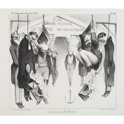
Les honneurs du Panthéon . . . . (Plate 433 from La Caricature.)
On the front wall is written: "To the great men and women, our country is grateful". This lithograph shows people hanging in front of the Panthéon, and may be ...
Place & Date: Paris, October 23, 1834
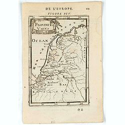
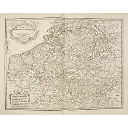
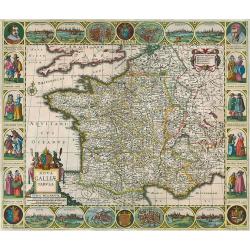
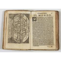
Provinces Unies.
A charming map of The Netherlands. Title in curtain draped at top. French text on verso.From the original 1683 text edition of "Description d'Univers. . ." by A...
Place & Date: Paris, 1683
Selling price: $1
Sold in 2023

Jerusalem.
Engraved by Bastiaan Stoopendaal from Juan Bautista Villapando's imaginary town-plan of Jerusalem. This bird's-eye view is surrounded by 12 scenes, views and portraits of...
Place & Date: Amsterdam, 1682
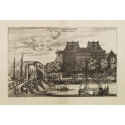
Magazin de la Compagnie Occidentale. - Het West Indisch Huys.
A decorative print of the West Indian House , the headquarters of the W.I.C., a place for meeting, trading and storage of spices and ship equipment. The maps and charts w...
Place & Date: Amsterdam, J. van Meurs, 1663
Selling price: $350
Sold in 2023
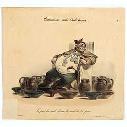
Caricature anti-cholérique La peur du mal donne le mal de la peur. (pl 1)
Caricature on hypochondria and protective measures against cholera. An overweight man seated in a chair surrounded by pitchers and bowls. In 1832, there was a devastating...
Place & Date: Paris, ca. 1830

Carta terza Generale del' Asia.
Rare first state of this important chart showing part of the north coast of New Guinea and islands of the Pacific Ocean. To the north of Japan the landmass of Isola di Ie...
Place & Date: Florence, 1646
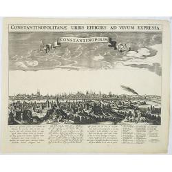
Constantinopolitanae urbis effigies ad vivum expressa.
A rare panoramic town-view of Istanbul with over the whole length of the lower part 3 columns of poems in Latin, Dutch and French and a numbered key 1-29 to the principal...
Place & Date: Amsterdam, 1660

Pascarte van Europa Beginnende vande Canael tot aen Spitbergen, en van Ysland tot aen Nova Zemla . . .
An eye-catching chart of northern Europe with a coastline from northern Russia to the Dutch English Channel in the south. Good detail on Iceland. North to the top.In the ...
Place & Date: Amsterdam, after 1666
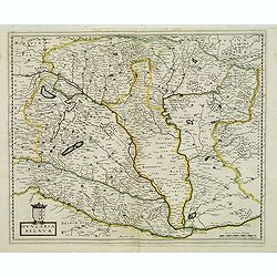
Carte Des Pays Bas Catholiques Dressée. . .
Topographically detailed map of the southern part of the Low Countries that extends from Paris to Metz and north into Holland. Details include roads towns and villages. T...
Place & Date: Paris, 1780
Funeral in China.
A scene of a funeral in China from Linschoten's famous voyages to the East of 1583-92 here published by De Bry the year after they first appeared as a separate book. From...
Place & Date: Frankfurt, 1599
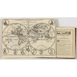
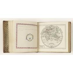
Introduction a la Geographie..
Second edition of this charming travel compendium illustrated with a fine world map in two hemispheres prepared by de l'Isle. California as an island. The hemispheres are...
- $2000 / ≈ €1871
Place & Date: Paris, 1717

Xantung, sinarum imperii provincia quatra.
A map of the northern province ‘Xantung’ of China after the Jesuit Martino Martini.Shows the Great Wall and is centered on the Bohai Sea, and the Shandong and Liaonin...
Place & Date: Amsterdam, ca 1660

Prospetto dell'anfiteatro Flavio . . . / Prospetto di Tutto l'Anfiteatro intiero . . . / Pianta dell' divisa nelli suoi / Spaccato, e veduta interiore dell' Anfiteatro.
Monumental engraving showing the Colloseum in Rome, in its setting, with below a ground-plan and elevation. Engraved and drawn by Alessandro Specchi (1668-1729), an engra...
Place & Date: Rome, 1703
![[Anti capitalism Soviet Union propaganda poster]](/uploads/cache/47035-250x250.jpg)
[Anti capitalism Soviet Union propaganda poster]
Propaganda mini anti-capitalism poster published in Russia during The Cold War. By the 1960’s and 1970’s, outrageous practices in Soviet bureaucracy flourished. Poor ...
Place & Date: Leningrad, 1974
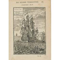
(Des Galeres - Shipping scene)
Miniature view of a vessel, showing the various types of sails. With key list in upper left corner.From the French text edition of Description d'Univers.. (5 volumes), 16...
Place & Date: Paris, 1683

Vue de Gattweick et de l'embouchure du Rhin, dans la Mer du Nord.
Very decorative view of Katwijk. Signed lower right, Louis Bleuler au chateau de Laufen . Original design by Louis Bleuer. This gouache was the model for his aquatint in ...
Place & Date: 1820

Cochin (today: Ernakulam)
Small but charming 18th water color on paper depicting Cochin (today : Ernakulam) was from 1500, when the first Portuguese fleet called on its port, a firm ally of the Po...
Place & Date: India? c.1750

Océanie.
A very decorative 19th century map of the Pacific Ocean, with hand colored lines indicating the extent of Polynesia, Micronesia, Melanesia, and Malaysia (or Southeast Asi...
Place & Date: Paris, 1850
Milan. Ville forte, Capitale du Duché de même nom, l'une des plus grandes des des plus considérables de l'Italie.
A very decorative and extremely rare of Milan, including a numbered key ( 1-35 ) in lower part. Published by Jacques Chéreau, (1688 - 1776). Engraved by Aveline and fir...
- $3500 / ≈ €3275
Place & Date: Paris, ca.1750

Tabula Asiae IIII. (Cyprus, Holy Land, Syria, Jordan, Iraq)
Gastaldi's map showing Cyprus, the Holy Land, Syria, Jordan and Iraq, based upon Ptolemy's map It is one of the earliest obtainable maps of the region.From Giacomo Gastal...
- $350 / ≈ €328
Place & Date: Venice, 1548
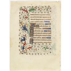
A manuscript leaf from a Book of Hours.
RECTO: Four 1-line initials in liquid gold on colored grounds. colorful panel border of acanthus leaves and flowers, with black penwork.VERSO: One 2-line initial and seve...
Place & Date: Western France, ca. 1445
IV. Cours du Po où sont les environs de Paivie, Plaisance, Cremone.. Milan.
Detailed small map centered on the stretch of the river Po flowing through the region Lombardy, between the area near Pavia and Cremona.Milan appears in the upper left co...
Place & Date: Paris, later than 1748

Carte géologique détaillée. Râchaïya Nord.
Geological or soil map showing part of Lebanon with Râchaïya , including a legend with signs of the different geological ages and giving many informations of greatest i...
Place & Date: Liban, Service geographique des F.F.L., 1945.
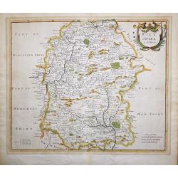
Wiltshire by Robert Morden.
Wiltshire by Robert Morden. 1722 is the 2nd state, with the incorrect village of "Quare" corrected to "North Burcomb" (West of Salisbury). The map is ...
Place & Date: London, 1722

La Florida/ Peruviae Auriferae regionis Typus/ Guastecan.
The Chaves map of Florida is a prime example of an explorer's map since it records the recent discoveries of Cabeza de Vaca, De Soto, and Moscoso. The map revealed little...
- $1400 / ≈ €1310
Place & Date: Antwerp, 1592
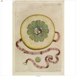
Eadem Aurantia Dimidiata.
Decorative engraving representing a citrus fruit. Taken from the book "Hesperides sive de malorum aureorum" by Giovan Battista Ferrari (Italian botanist, 1584-1...
Place & Date: Rome, Scheus, 1646

Turcici Imperii Imago.
The map shows the Ottoman Empire with Turkey, Black Sea, Mediterranean Sea, Arabia and North Eastern Africa. The map is decorated with a title cartouche and a portrait of...
Place & Date: Amsterdam, 1629
Himmels Atlas in 20 Blättzen nach den grossen Bodenschen Sernkarten…
Schreibers Erben, 1849. Publisher's binding with minor rubbing and wear to boards. Corners showing and some chipping at head of spine. 8 text pages and 20 engraved plates...
- $300 / ≈ €281
Place & Date: Leipzig, Schreibers Erben, 1849
Nova Galliae Tabula.
A Hondius rare "carte à figures" published by E. Cloppenburgh (second state). Separate publication. Nevertheless, despite its restorations, the map makes a gr...
Place & Date: Amsterdam, 1630-1643

Arabia Felice Nuova Tavola.
Fine early map of Arabian peninsula, being one of the earliest modern maps of the region.Girolamo Ruscelli first published the map in his "La Geographi di Claudio To...
Place & Date: Venice, 1561
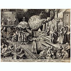
Temperance (Temperantia) from The Virtues.
Very decorative engraving by Philip Galle (Haarlem 1537–1612 Antwerp) after Pieter Bruegel the Elder (Breda (?) ca. 1525–1569 Brussels). The print was published by Hi...
Place & Date: Antwerp, Hieronymus Cock, 1580
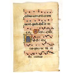
Leaf on vellum from an antiphonary.
A large vellum antiphonary leaf, written in Latin, probably Rome. RECTO: A wonderful initial ,Q, decorated with pen work in red, white and blue, in rich burnished gold.VE...
Place & Date: Italy, 1480
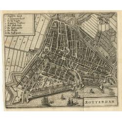
Rotterdam
Miniature bird's-eye plan of Rotterdam. It displays Rotterdam with the surrounding countryside and is decorated with the coat of arms.
Place & Date: Amsterdam, 1660
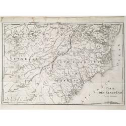
Carte des États-Unis, Provinces Méridionales.
The map shows portions of Kentucky, Virginia, Tennessee, Georgia, North Carolina, South Carolina, a strip of land between Tennessee and Georgia as 'United States Territor...
Place & Date: Paris, 1799
Selling price: $125
Sold in 2022
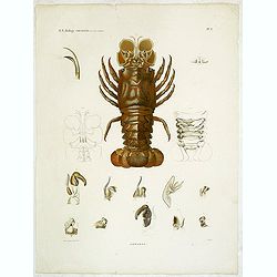
Hommards.
Decorative engraving of a lobster, by Tresca. Marie Jules César Lelorgne de Savigny (April 5, 1777 - October 5, 1851) was a French zoologist. In 1798 he traveled to Egyp...
Place & Date: Paris, 1822
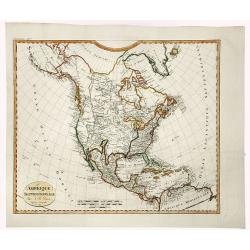
AMERIQUE SEPTENTRIONALE.
A detailed map of North America, issued shortly before the publication of the official account of Lewis & Clark's expedition to the Pacific Ocean. The map shows a ver...
Place & Date: Paris, 1809
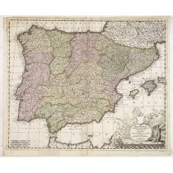
Hispaniarum Portugalliae que coronarum..
Detailed map of Spain and Portugal with large uncolored title cartouche.
Place & Date: Amsterdam, 1720

Vüe Perspective du Pont neuf construit sur la tamise a Hampton-Court.
So-called optical print illustrating a bridge on the river Thames at Hampton-Court.In the eighteenth and nineteenth centuries there were many popular speciality establish...
Place & Date: Paris, 1760

Chocolat Menier.
Chromo lithographed poster of Les Maîtres de l'Affiche being plate n°47. The "Les Maîtres de l'Affiche" contained 256 small for lithographic prints of the be...
Place & Date: Paris, Imprimerie Chaix, 1897
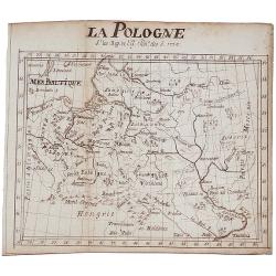
LA POLOGNE, (manuscript map)
A manuscript map of Poland. Comes with 5 leaves text titled "Pologne" , 10 pages text in French on Poland,Lithuania and the Ukraine. Leaf dimensions: width 14,1...
Place & Date: 1724
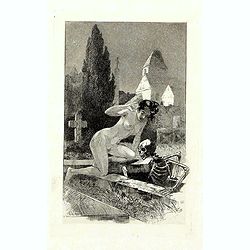
A rare suite of 12 original etchings by Martin van Maele to the famous work by Edmond Haracourt.
A rare suite of 12 original etchings by Martin van Maele to the famous work by Edmond Haracourt. The series was published anonymously in a small edition. These etchings a...
Place & Date: Nevers, Brussels, 1882,1883

Tabula Ducatus Brabantiae.
Detailed map orientated west to the top.
Place & Date: Amsterdam, 1680

Vaisseau du premier rang portant pavillon d'amiral.
Fine double-page engraved plate of a naval vessel, with the various parts of the ship numbered and identified. From Mortier's "Neptune François". From Mortier'...
Place & Date: Amsterdam, 1695
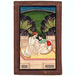
Indian painting on paper.
Fine miniature, presenting a couple in love making position, set on a balcony with in a landscape in the background. The miniature has been painted in India in late 19th ...
Place & Date: India, ca. 1900

(Untitled view from Scutari with a view of Constantinople)
Panoramic view from Scutari with a view of Constantinople in the distance, after a design by Johann Schranz. Published by J. Missiriè.
Place & Date: Paris, 1860
![[TAI travel poster]](/uploads/cache/44894-250x250.jpg)
[TAI travel poster]
A whimsical travel poster for "Transport Aeriens Intercontinentaux" (TAI), published in Paris in 1960, design by François Lesourt (Périgueux, 1913 - 1997). Th...
Place & Date: Paris, Hubert Baille & Cie Paris, 1960
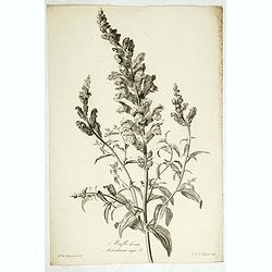
Mufle de veau. Antirrhinum majus L.
Bouquet of Common Snapdragons, engraving by P.F. Le Grand after designs by the Dutch born Gerard van Spaendonck (1746-1822).Taken from the rare work "Fleurs dessiné...
Place & Date: Paris, c.1800
Hungaria regnum.
Detailed map of Hungary. First edition of Sanson's map of the Kingdom of Hungary. Engraved by A. Peyrounin.
Place & Date: Paris, ca. 1640
Digitale pourprée. Digitalis purpurea L.
The foxglove, engraving by P.F. Le Grand after designs by the Dutch born Gerard van Spaendonck (1746-1822).Taken from the rare work "Fleurs dessinées d'après natur...
Place & Date: Paris, c.1800
Theatro del Mondo di Abrahamo Ortelio..
Including maps of the world (Shirley, World 214): Europe; Asia; America (Burden, America 126, Marchetti 1598); Africa; England; Scotland; Ireland; Tercera; Spain (4); Por...
Place & Date: Venice, G. Turrini, 1655

Het Klooster ten Hage (Marienhage Eindhoven)
Very rare lithography of the ruin of the monastery of Ten Haghe in Eindhoven. Lithographed by M.Mouret, published in "oud-Nederland en de uit vroegere dagen overgebl...
Place & Date: Nijmegen, 1837-1846

Carte des Principales Ports de Mer Bancs de sable &c: qui sont dans la Mer Rouge..
Some cities existed along the western coast of the Arabian peninsula, where they served as entrepots for transcontinental trade between Europe and Asia. Mecca, founded by...
Place & Date: Amsterdam, 1720

Carte de la Côte de Guzerat, Du Golf de Cambaye et des Côtes de Concan et De Canara.
French sea chart of West India from Gujarat to Mangalore. With inset chart Plan de la Rivière de Surate.Prepared by Jacques-François L'Abbé Dicquemare (1733-1789). La...
Place & Date: Paris, ca 1775
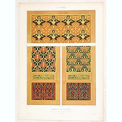
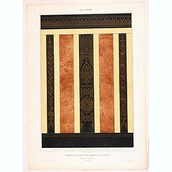
Art arabe. - Mosquée de Qaytbay.
Lithographed by Daumont. From the author's "L'Art Arabe d'après les monuments du Kaire…". Emile Prisse d'Avennes, Orientalist and Muslim convert, obsessive i...
- $50 / ≈ €47
Place & Date: Paris, 1877

Profil de la renomée ville et port d'Emstredam cappitalle des estats de Hollande.
Extremely rare panoramic town-view of Amsterdam seen from the river IJ.Exceptional bright, sharp example.The print is skillful copy of the print of Matthieu Merian, now w...
Place & Date: Paris, 1647

Beschrijving Gezicht van den Ykant af bezyden den Schreiers hoex Toren langs de Keulsche en Geldersche Kaei naer de Nieuwe Markt
This large engraving (560x920mm.) comes from a are series of 25 beautiful large views of Amsterdam and gives a colorful picture of the life and business of the city at th...
Place & Date: Amsterdam, ca. 1720

'T Eilandje Desima verblyf plaats der Hollanders in Japan.
Bird's-eye view of Dejima copied from a manuscript by Voogt, who was second-in-command on Deshima in 1713. The island is viewed from the landside, depicting the developme...
Place & Date: Amsterdam, 1739
![[Macaire] Abus de l'article 214 du code civil. Madame mon épouse... (Plate 50)](/uploads/cache/17389-250x250.jpg)
[Macaire] Abus de l'article 214 du code civil. Madame mon épouse... (Plate 50)
Macaire personified the clever business man, who was willing at any time to throw moral and ethical principles overboard for a quick buck. His personality fitted exactly ...
Place & Date: Paris, 1864
![[Russian Agitprop propaganda poster for 9 May]](/uploads/cache/42073-250x250.jpg)
[Russian Agitprop propaganda poster for 9 May]
Soviet propaganda poster celebrating Victory Day (Thursday 9 May). Showing a star with USA, English, French flags partly overlapped with Soviet flag and inscription in Ru...
Place & Date: Moskow, 1988
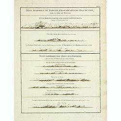
Vues diverses du fort de l'Agouade pres de l'isle de Goa . . . Sumatra . . .
French sea sea chart with 9 coastal views near Goa in India and Sumatra. The titles above the main profiles reading as following : Vues diverses du fort de l'Agouade pre...
- $200 / ≈ €187
Place & Date: Paris, Brest, Demonville, 1775
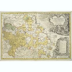
Principatus Silesiae Karnoviensis nova et exactissima Tabula. . .
Beautiful map of Opawa district in Silesia. Prepared by Johann Wolfgang Wieland (?-1736) and Mattheus von Schubarth (1723-1758). Published in Atlas Silesiae Id Est Ducatu...
Place & Date: Nuremberg, 1737 / 1750
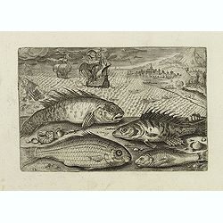
Glaucus, Cantharus, Salpa, Rarus. (Piscium Vivæ Icones - Fish)
Depiction of Glaucus, Cantharus, Salpa, Rarus. Fish set against a mountainous landscape in the manner of Pieter Brueghel the Elder. Plate number 12. The engraving is copi...
Place & Date: Antwerp, after 1598
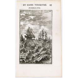
(Ships on full sea)
A fine engraving of different sailing vessels at full sea.From the French text edition of Description d'Univers.. (5 volumes), 1683. By Allain Manneson Mallet (1630-1706)...
Place & Date: Paris, 1683
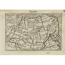
Tartaria.
A miniature map showing China, Korea and Russia. Title cartouche on the upper left corner.First published in 1598 in his Caert-Thresoor, the plates were executed by the m...
- $300 / ≈ €281
Place & Date: Amsterdam, 1609
Art arabe. - Tombeau du soultan qansou el-Ghoury.
Lithographed by Daumont. From the author's "L'Art Arabe d'après les monuments du Kaire…". Emile Prisse d'Avennes, Orientalist and Muslim convert, obsessive i...
- $50 / ≈ €47
Place & Date: Paris, 1877
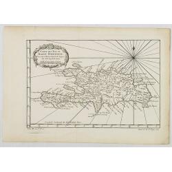
Carte de L'Isle de Saint Domingue. . . (Haïti)
Bellin's charming and well-detailed map of Haïti from Prevost d'Exiles famous travel and exploration book, "Histoire Générale des Voyages".
Place & Date: Paris, 1750
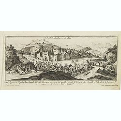
Het dal Terebinthus in Arabia.
Magnificent bird's eye- of Terebinthus north of Hebron. Etched by Gaspar Bouttats (1640-1695).The Antwerp-based publisher Jacques Peeters published ca. 1690 a series of p...
- $150 / ≈ €140
Place & Date: Antwerp, c.1690

Maris Pacifici.
From the rare Dutch text edition of the Theatrum of which according to van den Broecke only 100 copies are printed.This was the first printed map to be devoted solely to ...
Place & Date: Antwerp, 1598
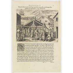
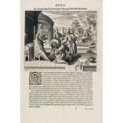
Argumentum I. Primus Lufitanorum cum Sogni praefecto congreffus, eiusdemque Baptismus, de quibus lib. 2 cap 2. fit mentio. (The arrival of the Portuguese in the county Sogno)
The arrival of the Portuguese in the county Sogno. When the Portuguese first discovered the county and the inhabitants of Sogno, they were taken for gods and received wit...
- $100 / ≈ €94
Place & Date: Frankfurt, 1598
Etrennes interessantes des quartre parties du monde..
A charming almanac for the year 1778. The maps are engraved by Durand et Le Roy, and each map has the name of the author Giovanni Antonio Battista Rizzi-Zannoni. This cha...
- $2500 / ≈ €2339
Place & Date: Paris, 1760
![[Libya]Nieuwe Pascaart voor een Gedeelte van de Zeekusten Van BARBARIA. Beginnende Van C. Mesurata Tot Caap Rusato Als Meede de West-kust van CANDIA. . .](/uploads/cache/82859-250x250.jpg)
[Libya]Nieuwe Pascaart voor een Gedeelte van de Zeekusten Van BARBARIA. Beginnende Van C. Mesurata Tot Caap Rusato Als Meede de West-kust van CANDIA. . .
A beautiful, old colored example of Van Keulen's chart of the coast of Barbaria, from Cape Rusato to Cape Mesurata, from his De Nieuwe Groote Lichtende Zee-Fackel, part I...
Place & Date: Amsterdam, ca 1680
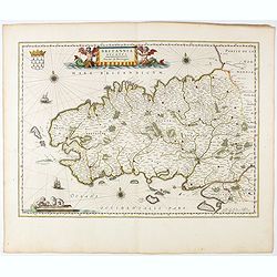
Britannia Ducatus. Duché de Bretaigne.
Map of Bretagne in France. From early on Willem Jansz. Blaeu aimed of publishing an atlas to compete with the Hondius-Jansson Atlas. By 1630, he had published at least 1...
- $800 / ≈ €749
Place & Date: Amsterdam, 1644
![Terre de Diemen. Arra-Maida. [plate XII]](/uploads/cache/46275-250x250.jpg)
Terre de Diemen. Arra-Maida. [plate XII]
A portrait of a female Tasmanian Aboriginal Arra-Maida, after the original sketches by Lesueur, from Voyage de découvertes aux terres Australes by François Péron, 1824...
- $100 / ≈ €94
Place & Date: Paris, 1824

Schlanium vulgo Schlani Bohemiae oppidum.
Very decorative and rare panoramic town view of Schlan, Schlanium s. Slany.The engraver and publisher of prints, Mrs. Anna Beek of the Hague, enlarged this print, origina...
Place & Date: The Hague, 1700

Indie moet vrij vecht ervoor.
War propaganda poster by Patrick (Pat) Cokayne Keely, distributed in the liberated South of the Netherlands, this poster concerned the Japanese occupation of Indonesia an...
Place & Date: London, J.Haworth / Brother Ltd, 1944
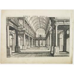
Perspective print by Vredeman de Vries.
Engraving from Les cinq rangs de l'architecture, a savoir, Tuscane, dorique, ionique, corinthiaque et composée avec l'instruction fondamentale. by Paul Vredeman de Vries...
Place & Date: The Hague, 1606
![DE WIT, Frederick. [Zee Atlas].](/uploads/cache/48904B-250x250.jpg)
DE WIT, Frederick. [Zee Atlas].
The charts are in very good condition, dark imprints and very decorative original strong coloring. A few have some very minor restoration in very few places, printed on s...
- $32000 / ≈ €29943
Place & Date: Amsterdam, ca. 1680
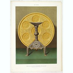
Art arabe. - Mobilier de soultan Mohammed Ben Qalaoûn flambeau et plateau d'alcarazas. . .
Lithographed by Daumont. From the author's "L'Art Arabe d'après les monuments du Kaire…". Emile Prisse d'Avennes, Orientalist and Muslim convert, obsessive i...
Place & Date: Paris, 1877
Selling price: $19
Sold in 2022
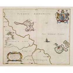
Insula Sacra, Vulgo Holy Iland, et Farne.
Double-page rare map of Holy Island and Farne Island off the coast of Northumberland. The Abbey, the Old Fort and the town are clearly marked. French text on verso.Taken ...
Place & Date: Amsterdam, 1645
Selling price: $200
Sold in 2023
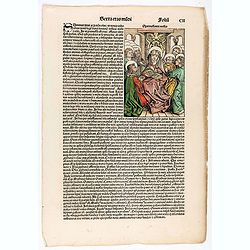
Quita Etas Mundi. Folium. CII
Text page with wood block cuts on recto MARY AND THE APOSTLES. The Virgin Mary is seated on a throne surrounded by the apostles, among whom we are able to identify Pe...
Place & Date: Nuremberg, 12 July 1493