Browse Listings in America > North America > North Pole

Homme & Femme de Népissens.
Hand-colored mezzotints of Native Americans engraved by Félix Mixelle and Lachaussée Jeune after Jacques Grasset de Saint-Sauveur.
Date: Paris,1801-1806
Selling price: ????
Please login to see price!
Sold in 2011
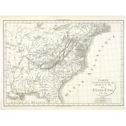
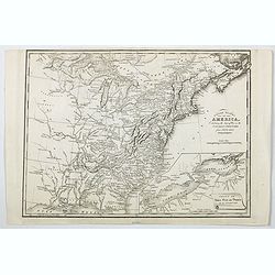
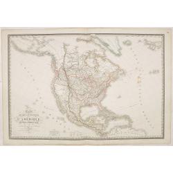
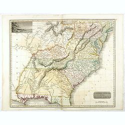
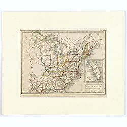
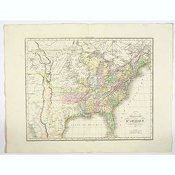
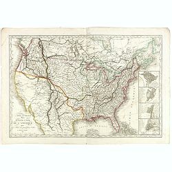
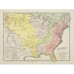
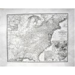
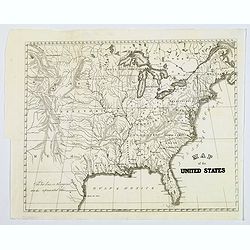
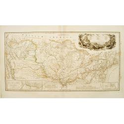
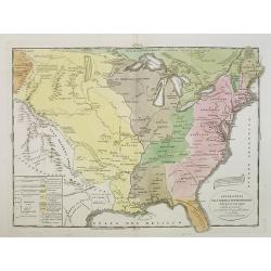
Carte des Etats du centre, de L'Quest et du Sud des Etats-Unis.
Detailed map of the East Coast of America, taken from "Voyage à l'Ouest des Monts Alléghanys, dans les Etats de l'Ohio, du Kentucky et du Tennessée, et retour à ...
Date: Paris, Dentu, 1808
Selling price: ????
Please login to see price!
Sold in 2015
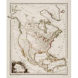
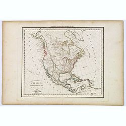
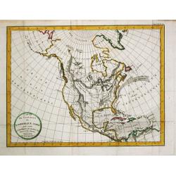
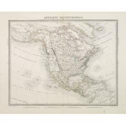
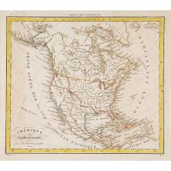
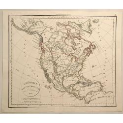
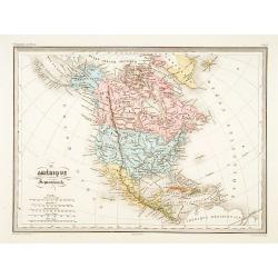
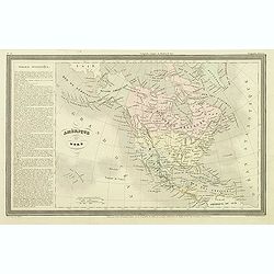
Amérique Septentrionale.
A charming map of North America. Very detailed. Published by Alexandre Emile Lapie, in his atlas Universel. Engraved by Tardieu.
Date: Paris 1809
Selling price: ????
Please login to see price!
Sold
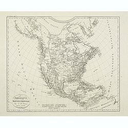
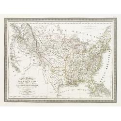
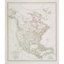
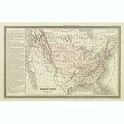
Amerique Septentrionale. . .
Detailed map of the United States and Canada giving good detail along the east coast and the Lakes. Including Port St.Francois, Monterey, Pte. De Pins, Pt.Estero, Pte de ...
Date: Paris, 1809
Selling price: ????
Please login to see price!
Sold in 2011
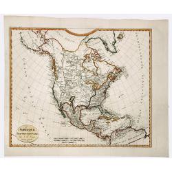
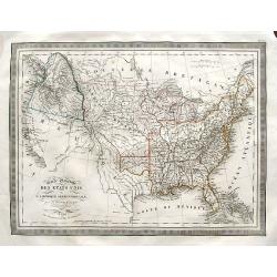
AMERIQUE SEPTENTRIONALE.
A detailed map of North America, issued shortly before the publication of the official account of Lewis & Clark's expedition to the Pacific Ocean. The map shows a ver...
Date: Paris, 1809
Selling price: ????
Please login to see price!
Sold in 2019
Amérique septentrionale.
A fine map of North America published by the well-known Paris publisher of maps, globes and atlases C.F. Delamarche.
Date: Paris, 1811
Selling price: ????
Please login to see price!
Sold in 2017
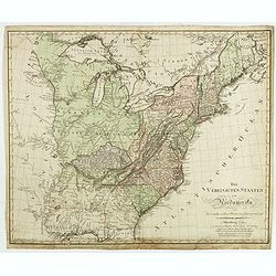
Die Vereinigten Staaten von Nordamerika nach Arrowsmith und Lewis Karten vom Jahre 1795 und 1796. . .
A uncommon map of the United States, according to the title based on the maps by Arrowsmith and Lewis published in 1795 and 1796. Roads and Indian tribes are noted, in ad...
Date: Nuremberg, 1812
Selling price: ????
Please login to see price!
Sold in 2016
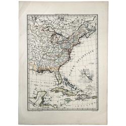
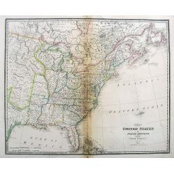
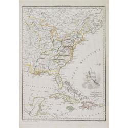
ETATS UNIS ET GRANDES ANTILLES.
An attractive map of the United States and West Indies with decorative cartouche, from 'Atlas Supplementaire du Precis de la Geographie Universalle de M. Malte-Brun by La...
Date: Paris, 1812
Selling price: ????
Please login to see price!
Sold in 2019
A Map exhibiting the frontiers of Canada and the United States, intended to illustrate the operations of the British & American armies
A scarce map issued during the War of 1812. Large inset lower right, "A sketch of the coast of North America; from the River St. Lawrence, to Chesapeake Bay." S...
Date: London, 1813
Selling price: ????
Please login to see price!
Sold in 2015
United States of America, Exhibiting the Seat of War on the Canadian Frontier from 1812 to 1815.
Edward Baines' 1816 map of the 'United States of America, Exhibiting the Seat of War on the Canadian Frontier from 1812 to 1815' A scarce of the US, published after the W...
Date: Leeds, 1816
Selling price: ????
Please login to see price!
Sold in 2021
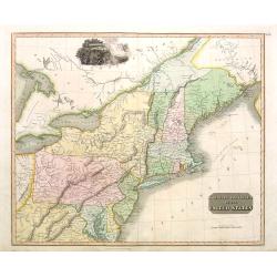
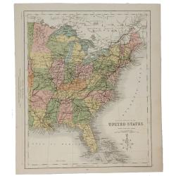
Northern Provinces of the United States.
Somewhat later but very finely engraved and detailed map of the United States.
Date: Edinburgh, 1817
Selling price: ????
Please login to see price!
Sold in 2008
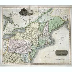
Nothern Provinces of the United States
Somewhat later but very finely engraved and detailed map of eastern part of the United States. Including the states and territories of New England, New York, Pennsylvania...
Date: Edinburgh, 1817
Selling price: ????
Please login to see price!
Sold in 2013
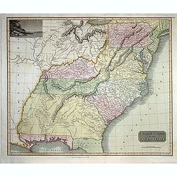
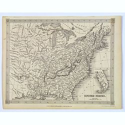
Southern Provinces of the United States
Somewhat later but very finely engraved and detailed map of the United States. Including the states and territories east of the Mississippi River to the Atlantic and as f...
Date: Edinburgh, 1817
Selling price: ????
Please login to see price!
Sold in 2013
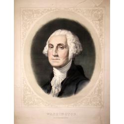
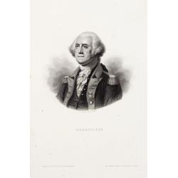
George Washington.
Rare lithographed portrait of George Washington, by an unknown artist; published by William Smith, 702 So. Third St, Philadelphia.Surrounded by scroll work.
Date: Philadelphia, c1820
Selling price: ????
Please login to see price!
Sold in 2016
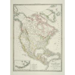
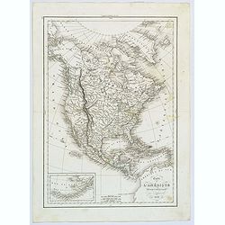
Carte du Continent de l\' Amerique Nord.
A map of North America.
Date: Paris, 1821
Selling price: ????
Please login to see price!
Sold in 2013
Carte Physique et Politique de l'Amérique Septentrionale. . .
Huge map of North America and the Caribbean showing the political divisions and colonial possessions with a color key at bottom. Brué prepared the maps for Louis de Onis...
Date: Paris, 1821
Selling price: ????
Please login to see price!
Sold in 2016
Spanish North America.
The excellent map by the Scottish engraver John Thomson, depicts Mexico from the Yucatan northwards to what would eventually become the Republic of Texas, and the Louisia...
Date: Edinburgh, 1821
Selling price: ????
Please login to see price!
Sold in 2016
Southern Provinces of the United States.
A very finely engraved and detailed map of United State, that Includes the states and territories east of the Mississippi River to the Atlantic and as far north as Lake E...
Date: Edinburgh, 1821
Selling price: ????
Please login to see price!
Sold in 2018
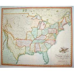
United States of America Compiled from the latest and best..
An uncommon and important map by the well recognized American cartographer John Melish, engraved by Samuel Harrison. Melish was the first American publisher to issue excl...
Date: Philadelphia, 1822
Selling price: ????
Please login to see price!
Sold
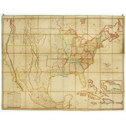
Map of the United States with contiguous British & Spanish Possessions.
.. compiled from the latest & best authorities by John Melish. Engraved by J. Vallance and [H.S.] Tanner. Entered according to Act of Congress the 16.th day of June 1...
Date: Philadelphia, 1822
Selling price: ????
Please login to see price!
Sold
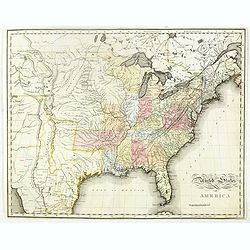
United States of America.
An uncommon and important map by the well recognized American cartographer John Melish. Shows both the newly formed state of Missouri and the massive Missouri Territory.M...
Date: Philadelphia, H.C. Carey & I. Lea, 1822
Selling price: ????
Please login to see price!
Sold in 2019
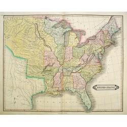
United States.
A small map of the east and south east of the United States. From Louisiana , up to the 'Northwest Territory' and across to New England and down to Florida. There is an i...
Date: London, 1822
Selling price: ????
Please login to see price!
Sold in 2019
Amérique septentrionale.
A fine map of North America published by the well-known Paris publisher of maps, globes and atlases.The map includes "Mormonfort" next to Lac Salé. Mormons arr...
Date: Paris, 1824
Selling price: ????
Please login to see price!
Sold in 2023

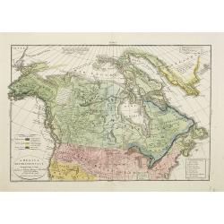
Freistaat von Nordamerica. . .
Scarce and unusual German map featuring primarily topography. Twenty-nine states and territories are outlined and named in a panel at bottom. A huge Louisiana stretches t...
Date: Berlin, 1824
Selling price: ????
Please login to see price!
Sold in 2016
Carte Générale des Etats Unis de L''Amérique Septentrionale..
Detailed map of the United States. Prepared by L.Vivien and engraved in steel by Giraldon-Bovinet.Published by Menard and Desenne, rue Git-le-Ceur 8, Paris.
Date: Paris, 1825
Selling price: ????
Please login to see price!
Sold in 2015
Carte Générale des Etats Unis de L'Amérique Septentrionale. . .
A highly interesting map of much of today's USA, the Bahamas, and parts of Canada. The map features the 54° 40' or Fight border with the huge Northwest region extending ...
Date: Paris, 1825
Selling price: ????
Please login to see price!
Sold in 2018
![North America [2 maps].](/uploads/cache/42445-250x250.jpg)
North America [2 maps].
A differing pair of North American maps, both published in 1820s, one in London, the other in Edinburgh. The map published by Constable, after Arrowsmith shows N. America...
Date: London, Edinburgh 1820 -1825
Selling price: ????
Please login to see price!
Sold in 2020
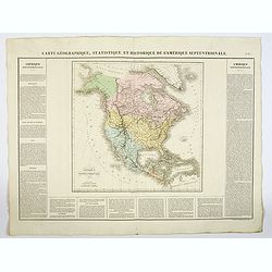
Carte Géographique, Statistique et Historique L'Amerique Septentrionale.
A lovely detailed map of North America, from Buchon's, Atlas Gégraphique Statistique, historique et chronologique des deux Ameriques et des isles adjacentes: traduit de ...
Date: Paris, 1825
Selling price: ????
Please login to see price!
Sold in 2019
Etats-Unis d'Amerique.
A nicely detailed map of the U.S.A., showing the various states with their political borders, in fine original colors. This interesting map shows the Oregon Territory, th...
Date: Paris, 1825
Selling price: ????
Please login to see price!
Sold in 2019
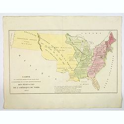
Carte de l'Adjonction Progressive des divers Etats au Territoire et a l'Union Constitutionnelle des Etats-Unis de l'Amerique du Nord. 1825.
An interesting map of the United States from Buchon's Atlas Gégraphique Statistique, historique et chronologique des deux Ameriques et des isles adjacentes, traduit de l...
Date: Paris, 1825
Selling price: ????
Please login to see price!
Sold in 2019
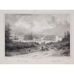
Bains de Saratoga / Saratoga Bath
From Jacques Gerard Milbert's Itineraire pittoresque du Fleuve Hudson et des parties laterales de l'Amerique du Nord.
Date: Paris, c.1826
Selling price: ????
Please login to see price!
Sold in 2010
Carte Generale Des Etats-Unis De L'Amerique avec les Plans des principales Villes...
Highly detailed coast-to-coast map of the United States, published by Eustache Herrison in Paris, engraved by J.B. Tardieu, with inset plans of Washington, Boston, Philad...
Date: Paris, Jean, 1826
Selling price: ????
Please login to see price!
Sold in 2020

John Adams.
Lithographed portrait of John Adams, by Ch. Motte after Mauraisse. Dated and signed by Mauraisse lower left part.Seal carrying the Initials Q.M. and the lettering Contemp...
Date: Paris 1827
Selling price: ????
Please login to see price!
Sold
Amérique septentrionale..
General map of north America.
Date: Paris 1828
Selling price: ????
Please login to see price!
Sold
Amérique Septentrionale . . .
Detailed map of North America, prepared by A. H. Basset, rue Saint-Jacques, no. 64, Paris and published in Atlas classique et Universel de Géographie . . . .The engraver...
Date: Paris, A.H. Basset, 1828
Selling price: ????
Please login to see price!
Sold in 2022
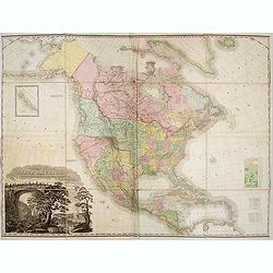
A Map of North America, Constructed According To The Latest Information ... Improved to 1828.
It says in the title : "improved to 1828". This milestone map was first issued issued separately in 1822 and also bound in four sheets into Tanner's "New ...
Date: Philadelphia, Henry Tanner, after 1828
Selling price: ????
Please login to see price!
Sold in 2013
Amerique Septentrionale.
A fine map of North America published by the well-known Paris publisher of maps, globes and atlases C.F. Delamarche.C.F. Delamarche (1740-1817) was a French geographer an...
Date: Paris, 1828
Selling price: ????
Please login to see price!
Sold in 2019
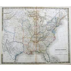
United States.
"Uncommon detailed steel engraved map of the United States. Published in Edinburgh by Daniel Lizars. A detailed showing the states and territories from Missouri east...
Date: Edinburgh 1833
Selling price: ????
Please login to see price!
Sold
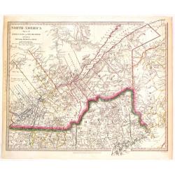
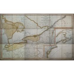
North America (Sheet II) Lower Canada and New Brunswick with a Part of New York, Vermont and Maine.
Very detailed sectional map of North America published by Baldwin & Cradock under the superintendence of the Society for the Diffusion of Useful Knowledge in London i...
Date: London, 1833
Selling price: ????
Please login to see price!
Sold in 2015
America Settentrionale..
Rare and detailed map of the northern part of the United States of America and Canada, including Alaska, engraved by Marco Zuliani. According to the title cartouche, prep...
Date: Venice, 1835
Selling price: ????
Please login to see price!
Sold in 2011
Stati-Uniti Dell'America settentrionale. . .
Rare and detailed map of eastern part of the United States of America, including Great Lakes, Florida, engraved by Marco Zuliani. According to the title cartouche, prepar...
Date: Venice, 1835
Selling price: ????
Please login to see price!
Sold in 2011
United States.
A detailed map of the United States shown until Texas and the Western Territory. Shows a large area labeled Nebraska.Includes some of the first railroads along the East C...
Date: London, ca. 1835
Selling price: ????
Please login to see price!
Sold in 2017
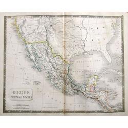
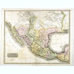
Mexico. And Central States Corrected from original information communicated by Simon A.G. Bourne Esq.
An important map of the South-West US, with Texas and Upper, or New California. With excellent detail throughout Mexico and until Costa Rica.Mines in Mexico are noted by ...
Date: London, ca. 1835
Selling price: ????
Please login to see price!
Sold in 2018
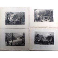
Four Bartlett steel Engravings - North American Rivers.
Four fine steel engraving prints by William Bartlett. Included are:- The Banks of the River Niagara- Bridge Near Quebec- The Outlet of Niagara River - Wolf's CoveWilliam ...
Date: London, 1836
Selling price: ????
Please login to see price!
Sold in 2016
Amérique Septentrionale.
Fine map of North America.From Malte-Brun's Atlas Géographie Universelle.."., revised by Jean Jacques Nicolas Huot.This very fine executed map has been printed by F...
Date: Paris, 1837
Selling price: ????
Please login to see price!
Sold in 2011
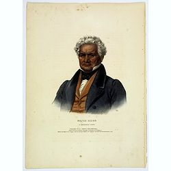
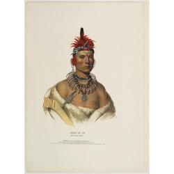
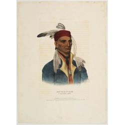
Major Ridge. A Cherokee Chief.
Head and shoulders portrait of Major Ridge,(1771-1839) wearing a blue jacket, gold or yellow vest, white shirt, and black cravat. A Cherokee Chief, who as a Cherokee lead...
Date: Philadelphia, 1837
Selling price: ????
Please login to see price!
Sold in 2017
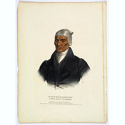
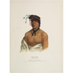
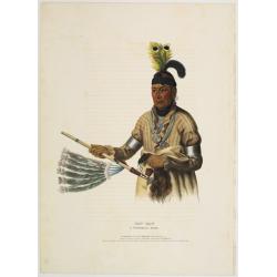
Ca-Ta-He-Cas-Sa-Black Hoof. Principal Chief of the Shawanoes.
Half-length portrait of Catahecassa wearing a dark colored jacked, grey vest, white shirt, and grey head scarf.A wonderful hand colored lithograph of Ca-Ta-He-Cas-Sa-Blac...
Date: Philadelphia, 1837
Selling price: ????
Please login to see price!
Sold in 2017
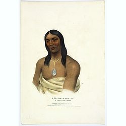
A-Na-Cam-E-Gish-Ca. A Chippeway Chief.
Half-length portrait of Anacamegishca, bare-chested, wearing a blanket and a peace medal. A-Na-Cam-E-Gish-Ca (1785-1862) - was a Chippeway Indian Chief. The Chippewa is o...
Date: Philadelphia, 1837
Selling price: ????
Please login to see price!
Sold in 2017
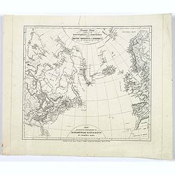
General Chart exhibiting the Discoveries of the Northmen in the Arctic Regions and America. . .
An interesting Danish map of many northern discoveries from the 10th to the 14th centuries, published by the Royal Society of Northern Antiquaries in Denmark. Map is base...
Date: Copenhagen, 1837
Selling price: ????
Please login to see price!
Sold in 2017
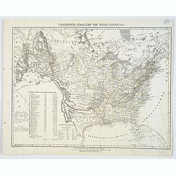
Young's Reise=Charte durch die Vereinigten Staaten von Nord America. Enthaltend alle Strassen, Dampfboot und Canal = Stationen, Staedte, Dorfer und Ansiedlungen. . .
A large, very detailed early German edition of J.H. Young's map of the United States. The translation of the German title reads: "Young's travel = Map of the United ...
Date: Nurenberg, 1837
Selling price: ????
Please login to see price!
Sold in 2022
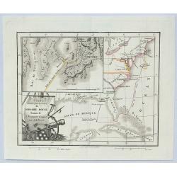
Carte Dressee pour la Lecture du Corsaire Rouge Roman de J. Fenimore Cooper.
A finely engraved map of the eastern part of America from Portland around to Louisiana. It has an insert of Newport, Rhode Island. Featured is a title cartouche of arms....
Date: Paris, 1837
Selling price: ????
Please login to see price!
Sold in 2023
Carte de l'Amérique Septentrionale ..
Prepared by Alexandre Emile Lapie, a Colonel de l'Etat Major and first geographer to the King. Published by P.C.Lehuby, Rue de Seine 48, Paris. Engraved by Tardieu. Givin...
Date: Paris 1838
Selling price: ????
Please login to see price!
Sold
Map of the United States.
General map of the United States, dated around 1838 and shows Texas. Some place names, but mostly rivers and tributaries, lakes, territories mountains and some Indian tri...
Date: America, 1838
Selling price: ????
Please login to see price!
Sold in 2017
The United States of North America, with the British Territories.
A highly detailed map of the United States, extending from Missouri and Texas to New Found Land and the Bahamas.With some early names of regions, and several interesting ...
Date: London, 1838
Selling price: ????
Please login to see price!
Sold in 2017
Carte de l'Amerique Septentrionale.
French map of North America showing Oregon Territory extending north into British Columbia in Canada, Missouri Territory extends from the shores of Lake Michigan across t...
Date: Paris, 1838
Selling price: ????
Please login to see price!
Sold in 2017
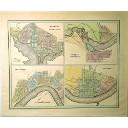
Washington, Louisville & Jefferson, New Orleans & Cincinnati.
Four city maps in full color. The map of Washington includes numbered locations including the Capitol, the State Department, Departments of War, Navy, and the Treasury, a...
Date: New York, 1838
Selling price: ????
Please login to see price!
Sold in 2019
Carte itinéraire du Prince Maximilien..
Engraved map of the interior of the Northern U.S., from Atlantic seaboard to the Rocky Mountains with outline coloring indicating the route of travels and Indian nations....
Date: Paris, Coblenz, or London, 1839
Selling price: ????
Please login to see price!
Sold
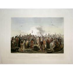
Scalp Dance of the Minatarris/ Scalptanz der Moennitarris/ Danse du Scalp des Indiens Meunitarris.
Print from: 'Reise in das innere Nord-America in den Jahren 1832 - 1834' by Prince Maximilian of Wied-Neuwied, after paintings by Karl Bodmer, engraved by Ch. Vogel, prin...
Date: London, 1839
Selling price: ????
Please login to see price!
Sold in 2015
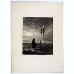
Offrande des Indiens Mandans.
This bleak, evocative and deeply spiritual engraving by Bodmer shows a Mandan skull shrine in 1833, located near the burial ground of Mih-Tutta-Hang-Kusch.Titles in Germa...
Date: Pars, Coblenz, London, 1839
Selling price: ????
Please login to see price!
Sold
États Unis et Grandes Antilles.
America's east coast, the Great Lakes, Florida and the Caribbean.
Date: Paris, 1840
Selling price: ????
Please login to see price!
Sold in 2017
Washington.
Steel engraved portrait of Georges Washington, engraved by Ballin. Published by Dufour, Mulat et Boulanger Imp. Gilquin et Dupain, r. de la Calandre, 19, Paris.
Date: Paris ca 1840
Selling price: ????
Please login to see price!
Sold
Stati-Uniti Dell'America settentrionale . . .
A rare and detailed double-page map of eastern part of the United States of America, including Great Lakes, Florida, engraved by G.V.Pasquali. According to the title cart...
Date: Venice, 1840
Selling price: ????
Please login to see price!
Sold in 2016

America Settentrionale disegnata dopi i viaggi di Lewis, Clarke, Parry e Franklin. . .
A rare and detailed double-page map of eastern part of the United States of America, including Great Lakes, Florida, engraved by G.V.Pasquali.According to the title carto...
Date: Venice, 1840
Selling price: ????
Please login to see price!
Sold in 2018
Amerique du nord.
The map depicts the short lived "Republic of Fredonia," a reference to the Fredonia Rebellion, the first attempt to create a separate independent Republic in Te...
Date: Paris, Jules Renouard, ca.1840
Selling price: ????
Please login to see price!
Sold in 2012
Etats-Unis.
Finely engraved map prepared by A.H.Dufour and engraved by Giraldon-Bovinet, shortly before Texas became part of the United States. After gaining independence from Spain ...
Date: Paris, Jules Renouard, ca.1840
Selling price: ????
Please login to see price!
Sold in 2012
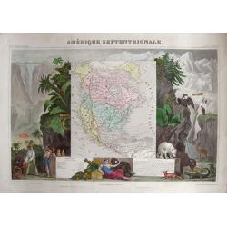
Amérique Septentrionale.
Very attractive map of America. To the left we find traders negotiating home-made products and a Maya pyramid. To the right we find plants and animals that are common for...
Date: Paris, 1840
Selling price: ????
Please login to see price!
Sold in 2014
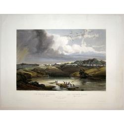
The White Castles on the Upper Missouri/ Die Weissen Schloesser am oberen Missouri/ Les Chateaux Blancs Missouri superior.
Aquatint from: 'Reise in das innere Nord-America in den Jahren 1832 - 1834' by Prince Maximilian of Wied-Neuwied, after paintings by Karl Bodmer, engraved by Himely, prin...
Date: London, 1840
Selling price: ????
Please login to see price!
Sold in 2015
Vereinigte Staaten von Nord-America.
This handsome German map highlights the United States and her Territories, as numbered and outlined in yellow. The Republic of Texas (an independent nation until joining ...
Date: Glogau, ca 1840
Selling price: ????
Please login to see price!
Sold in 2020
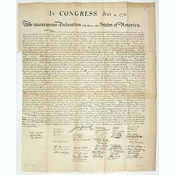
In congress, July 4, 1776. The unanimous declaration of the thirteen united Styates of America.
Scarce French reproduction based on William J. Stone’s official copperplate facsimile done by order of Congress. This French edition of the Declaration of Independance ...
Date: Paris, Kaeppelin & Cie, 1840
Selling price: ????
Please login to see price!
Sold in 2019
Eastern Division of the United States.
A fine chromolithograph map of the Eastern United States and parts of Canada. The Sioux, Fox, Chippewa and Algonquin Indian tribes are all mentioned. The capital of Arkan...
Date: London, 1840
Selling price: ????
Please login to see price!
Sold in 2021
United States.
This detailed map of the United States that extends to show the eastern part of the Republic of Texas and a vast, and as yet unnamed western territory to the northwest of...
Date: London, 1841
Selling price: ????
Please login to see price!
Sold in 2019
Chono Ca Pe an Ottoe chief.
A beautifully defined lithograph of Ottoe Indian Chief Chono Ca Pe from McKenney & Hall?s History of the Indian Tribes, perhaps the most important work ever published...
Date: Philadelphia, circa 1836-1842
Selling price: ????
Please login to see price!
Sold
Wesh-Cubb a Chippway chief.
A beautifully defined lithograph of Chippway chief Wesh-Cubb from McKenney & Hall?s History of the Indian Tribes, perhaps the most important work ever published on No...
Date: Philadelphia, circa 1836-1842
Selling price: ????
Please login to see price!
Sold
Naw-Kaw a Winnebago chief.
A beautifully defined lithograph of Winnebago chief Naw-Kaw, wearing a striped shirt, three peace medals around his neck, holding a peace pipe in one hand, what looks lik...
Date: Philadelphia, circa 1836-1842
Selling price: ????
Please login to see price!
Sold
Shin-Ga-Ba-W'Ossin a Chippeway chief.
A beautifully defined lithograph of Chippeway chief Shin-Ga-Ba-W'Ossin from McKenney & Hall?s History of the Indian Tribes, perhaps the most important work ever publi...
Date: Philadelphia, circa 1836-1842
Selling price: ????
Please login to see price!
Sold

Se-Quo-Yah.
A beautifully defined lithograph of Se-Quo-Yah, or George Guess, the son of a white man and an Indian woman of mixed blood, recognized to this day for his creation of an ...
Date: Philadelphia, circa 1836-1842
Selling price: ????
Please login to see price!
Sold

Qua-Ta-Wa-Pea a Shawanoe chief.
A beautifully defined lithograph of Shawanoe chief who is wearing a Jefferson peace medal. From McKenney & Hall?s History of the Indian Tribes, perhaps the most impor...
Date: Philadelphia, circa 1836-1842
Selling price: ????
Please login to see price!
Sold

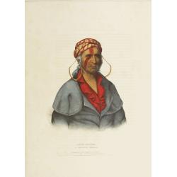
Mo-Hon-Go an Osage woman.
This hand-colored lithograph of Mo-Hon-Go, one of only eight women whose portraits appeared in this book. By contrast there were 111 men's portraits in it. Mo-hon-go, fl....
Date: Philadelphia, circa 1836-1842
Selling price: ????
Please login to see price!
Sold in 2008
Little-Crow a Sioux Chief.
This hand-colored lithograph of Little-Crow a Sioux Chief. Chief Little Crow was the eldest son of Cetanwakuwa (Charging Hawk). It was on account of his father's name, mi...
Date: Philadelphia, circa 1836-1842
Selling price: ????
Please login to see price!
Sold
Payta-Kootha a Shawanoe Warrior.
This hand-colored lithograph of Flying Clouds (Payta-kootha) (Shawnee) was probably painted by King in Washington, D.C., but the date is unknown. He was an itinerant, sel...
Date: Philadelphia, circa 1836-1842
Selling price: ????
Please login to see price!
Sold

