Browse Listings in America > North America > North Pole
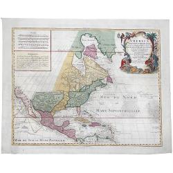
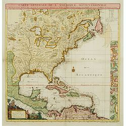
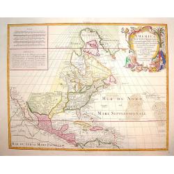
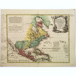
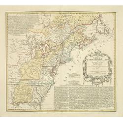
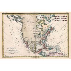
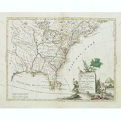
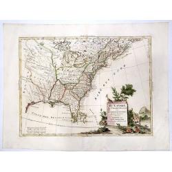
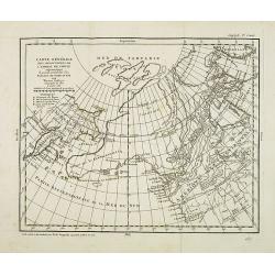
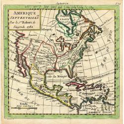
America Septentrionalis concinnata...
A copperplate colored map of the north east America, that shows California as an island, after the foundation map by de L'Isle published in 1700, which was the first map ...
Date: Augsburg, 1760
Selling price: ????
Please login to see price!
Sold in 2017
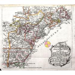
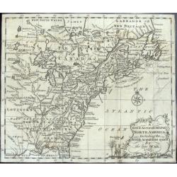
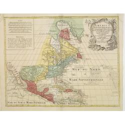
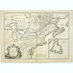
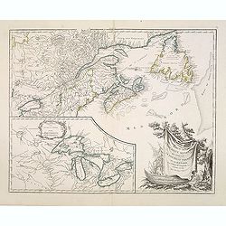
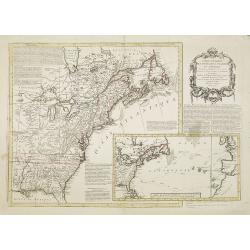
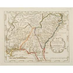
America septentrionalis oder Mitternachtiger theil von America bestehend in Neu Brittania, Canada, Neu Engeland, Neu Schotland, Neu Jorck, Pensylvania, Carolina, Florida, Georgien. . .
A rare German map of the East Coast of North America. Shows the British Colonies at the end of the Franco-Indian War, and extends from Newfoundland until Florida, and wes...
Date: Augsburg, ca 1760
Selling price: ????
Please login to see price!
Sold in 2018
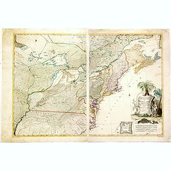
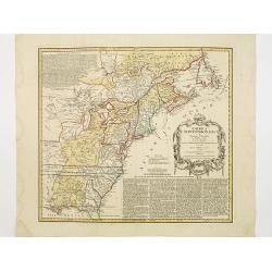
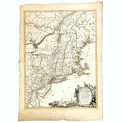
Theatrum belli in America Septentrionali. II. foliis comprehensum jussu Acad. Reg. Scient. et Eleg. Litt. exhibet I. C. Rhode Ac: Geogr.
Separately issued map of the northeastern part of the United States and Eastern Canada from the Mississippi Valley to the Atlantic Seaboard, published during the French a...
Date: Berlin, 1761
Selling price: ????
Please login to see price!
Sold in 2018
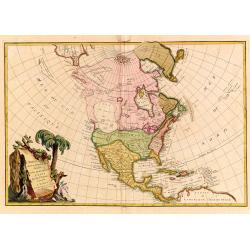
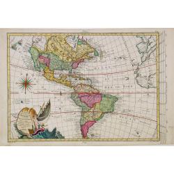
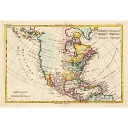
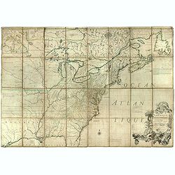
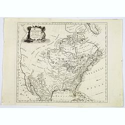
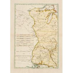
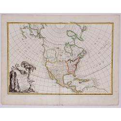
L'Amerique Septentrionale divisé en fes principaux.
A finely engraved map of North America, prepared by Janvier. The map is most notable for it's depiction of Mer de L'Quest or Sea of the West, a great sea, easily the size...
Date: Paris 1762
Selling price: ????
Please login to see price!
Sold
![L' AMERIQUE SEPTENTRIONALE divisee en les principaux ETATS.[Great western sea, First State]](/uploads/cache/82867-250x250.jpg)
L' AMERIQUE SEPTENTRIONALE divisee en les principaux ETATS.[Great western sea, First State]
First state for this very important map. Engraved by Lattré. This map is most notable for it's depiction of Mer de L'Quest or Sea of the West, near modern-day Seattle. A...
Date: Paris, 1762
Selling price: ????
Please login to see price!
Sold in 2019
Carte Générale de l' Amérique Séptentrionale ..
Uncommon 3rd version of Le Rouge's Popple key map by Crepy. This state 3 is a variant of state 2 (from the same plate) except: title at top now states: CARTE GÉNÉRALE D...
Date: Paris, ca. 1763
Selling price: ????
Please login to see price!
Sold
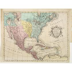
A New map of North America from the latest discoveries 1763.
From London magazine, January 1763.
Date: London, c.1763
Selling price: ????
Please login to see price!
Sold in 2013
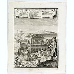
Veduta d'un palco, e della maniera colla quale si pesca acconcia e secca il Baccala in Terra nuova.
This is a view of a cod or fish drying station (stage) in New France or Newfoundland. Includes men fishing for cod, unloading catch from a boat, processing and fileting f...
Date: Livorno, 1763
Selling price: ????
Please login to see price!
Sold in 2015
A New Map of North America from the Latest Discoveries.
A nice detailed map of the British Colonies in North America, published at the end of the French & Indian War. The claims of the Carolinas, Virginia and New England n...
Date: London, 1763
Selling price: ????
Please login to see price!
Sold in 2020
A New & Accurate Map of North America, Including the British Acquisitions gain'd By the late War. 1763
Scarce map of the eastern part of North America from James Bay to the Gulf of Mexico in the year 1763. It shows boundaries, colonies, towns, cities, forts, and Indian tri...
Date: London, ca. 1765
Selling price: ????
Please login to see price!
Sold in 2016
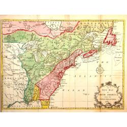
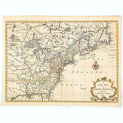
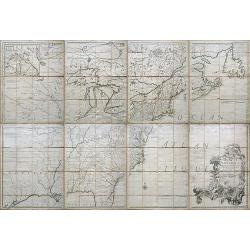
![[North America].](/uploads/cache/39534-250x250.jpg)
[North America].
Two sheets (nos 1 & 3) of a larger 4 sheet wall map of North America, published by Postlethwayt, from his "Dictionary of Trade and Commerce".The work is bas...
Date: [London], ca. 1766
Selling price: ????
Please login to see price!
Sold in 2017
Carte Nouvelle d'Amerique..
Fine map of north and south America, engraved by J.E.T. Vallet and prepared by M.A.Moithey. In western part of North America a large "Mer de L' Quest" or Sea of...
Date: Paris 1767
Selling price: ????
Please login to see price!
Sold
North America.
A nice general map of North America, published in London during the latter half of the eighteenth century. It mentions many Native American Indian Tribes, shows 'New Albi...
Date: London, 1767
Selling price: ????
Please login to see price!
Sold in 2019
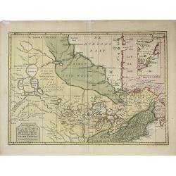
Nieuwe Kaart van Kanada, De Landen aan de Hudson's-Baay en de Noordwestelyke deelen van Noord-Amerika. . .
A decorative, interesting map of Canada and the Upper Midwest. It is centered on the Great Lakes and Hudson's Bay and was published by Issak Tirion. The map depicts the r...
Date: Amsterdam, 1769
Selling price: ????
Please login to see price!
Sold in 2022
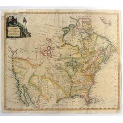
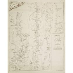
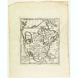
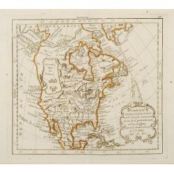
America Septentrionalis, Concinnata juxta Observationes..
This exemplar represents Lotter?s version of Delisle?s foundation map of North America, published in 1700. The Great Lakes are actually based on the Coronelli model, whic...
Date: Augsburg, ca. 1770
Selling price: ????
Please login to see price!
Sold
America Septentrionalis, Concinnata juxta Observationes..
This exemplar represents Lotter's version of Delisle's foundation map of North America, published in 1700. The Great Lakes are actually based on the Coronelli model, whic...
Date: Augsburg, ca. 1770
Selling price: ????
Please login to see price!
Sold in 2011
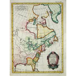
Amérique Septentrionale.
25Rigobert Bonne (1727-1795), French cartographer. His maps are found in a.o. Atlas Moderne (1762), Raynal's Histoire Philos. du Commerce des Indes (1774) and Atlas Encyc...
Date: Paris, c. 1770
Selling price: ????
Please login to see price!
Sold
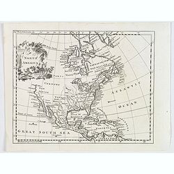
N. America.
Uncommon map of North America, with unfinished coast north of California. Shows "Quivira" and "The supposed Str. of Annian". Locates Indian tribes.
Date: London, ca. 1770
Selling price: ????
Please login to see price!
Sold in 2014
North America Drawn & Engraved from the best Maps & Charts.
Important early hand-colored, copper engraved map of the British Colonies and the whole of North America, shortly after the conclusion of the French & Indian War and ...
Date: London, 1770
Selling price: ????
Please login to see price!
Sold in 2015
America Septentrionalis, Concinnata juxta Observationes..
This exemplar represents Lotter's version of Delisle's foundation map of North America, published in 1700. The Great Lakes are actually based on the Coronelli model, whic...
Date: Augsburg, ca. 1770
Selling price: ????
Please login to see price!
Sold in 2018
Partie de la carte du Captaine Cluny..
From Diderot's Encyclopaedia . Based on Captain Cluny's map of 1769 published in London in American Traveller .
Date: Paris 1771
Selling price: ????
Please login to see price!
Sold
Partie de la carte du Capitaine Cluny? publié en 1769.
A map of North America with a supposedly northwest passage.
Date: Paris, 1772
Selling price: ????
Please login to see price!
Sold
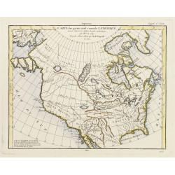
Carte des parties nord est ouest de L'Amerique..
Map of North America, as well as Canada & Alaska. California & the Pacific Northwest coast to Alaska is still speculative, whereas the east coast is depicted from...
Date: Paris 1772
Selling price: ????
Please login to see price!
Sold
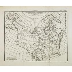
Carte des parties nord et ouest de l' Amerique. . .
Map of North America, as well as Canada & Alaska. California & the Pacific Northwest coast to Alaska is still speculative, whereas the east coast is depicted from...
Date: Paris, 1772
Selling price: ????
Please login to see price!
Sold in 2014
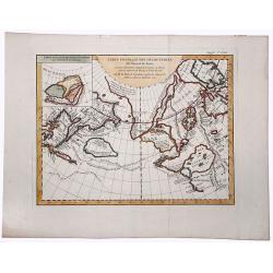
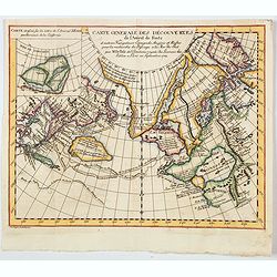
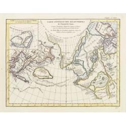
CARTE GENERALE DES DECOUVERTES de l'Amiral de Fonte, et autres navigateurs. . .
An extremely interesting map of the Northwest Coast, showing De L'Isle's conjectural northwest coast, based upon De Font and Russian Discoverers, including the Bay of the...
Date: Paris, 1772
Selling price: ????
Please login to see price!
Sold in 2019
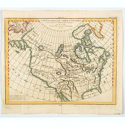
Carte des parties nord et ouest de L' Amerique. . .
An interesting map of North America, based upon an earlier map by Thomas Engel. His map of North America was issued in his 'Memoires Observations Geographique' in 1765, a...
Date: Paris, 1772
Selling price: ????
Please login to see price!
Sold in 2020
Carte generale des Decouvertes de L'Amiral de Fonte. . .
An interesting map of the northwest coast, showing de L'Isle's conjectural northwest coast, based upon that of de Font and Russian Discoverers, including the Bay of the W...
Date: Paris, 1772
Selling price: ????
Please login to see price!
Sold in 2020
General Map of the Discoveries of Admiral de Fonte representing the great probability of a Passage to the North West by Thomas Jefferys. . .
An attractive and interesting map issued in the supplement to Diderot's 'Encyclopedie' as part of the series of ten maps by de Vaugondy illustrating the then-current view...
Date: Paris, 1772
Selling price: ????
Please login to see price!
Sold in 2020
Partie du Nord de l' Amerique Septentrionale.
Rigobert Bonne (1727-1795), French cartographer. His maps are found in a.o. Atlas Moderne (1762), Raynal's Histoire Philos. du Commerce des Indes (1774) and Atlas Encyclo...
Date: Paris, 1774
Selling price: ????
Please login to see price!
Sold
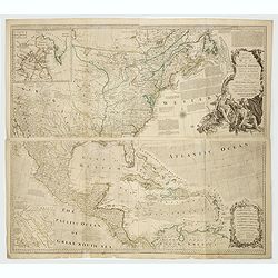
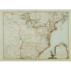
An Accurate Map of North America. Describing and Distinguishing the British and Spanish Dominions on this Great Continent. According to the Definitive Treaty Concluded at Paris 10th Feb. 1763.
The outstanding British map of North America created on the eve of the American Revolution, this is the desirable fourth Robert Sayer (1725-1794) issued 1775 edition of B...
Date: London, Robert Sayer, 1775
Selling price: ????
Please login to see price!
Sold in 2022
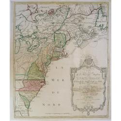
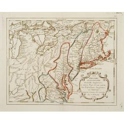
A map of the middle British colonies in North America.
A separately published copper engraving in one sheet. The map shows geography from the mouth of the Delaware to the eastern edge of New York; inland, it shows the Susqueh...
Date: London, 1776
Selling price: ????
Please login to see price!
Sold

The Parricide. A Sketch of Modern Patriotism. Westminster Magazine, vol. IV, 1st May 1776.
Britannia attacked by America and the British lion.Reaction against ministers who supported the American cause. Images include: John Wilkes (1725-1797); America as a woma...
Date: London, 1776
Selling price: ????
Please login to see price!
Sold in 2018
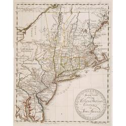
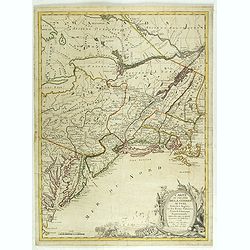
Amerique Septentrionale avec les Routes, Distances en miles, Villages et Etablissements François et Anglois Par le Docteur Mitchel Traduit de l'Anglois ... Corigee en 1776 par M. Hawkins... Verbessert 1776
Second impression of third French edition of the famous John Mitchell map of the British and French Dominions in North America which was first published in 1755. Title in...
Date: Paris, 1776
Selling price: ????
Please login to see price!
Sold
Carte Nouvelle de l'Amerique Angloise Contenant tout ce que les Anglois Possedent sur le Continent de l'Amerique Septentrionale Savoir le Canada, la Nouvelle Ecosse ou Acadie, les Treize Provinces Unies...
This fine and large map was issued shortly before the outbreak of the American Revolution and was included in Lotter's Atlas Geographique. The map covers the region from ...
Date: Augsburg, 1776
Selling price: ????
Please login to see price!
Sold in 2019
America Septentrionalis a Domino d'Anville..
The map is throughly annotated in German. Interesting map of the Colonies at the outset of the French & Indian War. Some of the interesting features include a truncat...
Date: Nuremberg 1777
Selling price: ????
Please login to see price!
Sold
Cours de la rivière d'Hudson avec la communication avec le Canada par le Lac Champlain jusqu'au Fort Chambly par Sauthier a 4 Mmiles pour pouce anglois.
Le Rouge's version of this important large-scale map of Claude Sauthier's map of the course of the Hudson River. The map was the inset map of a 4 sheet map entitled "...
Date: Paris, 1777
Selling price: ????
Please login to see price!
Sold in 2008
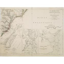
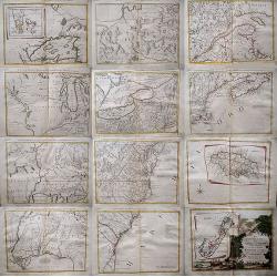
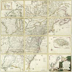
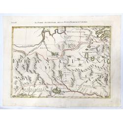
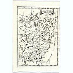
Caroline Septentrionalr et Meridionale en 4 Feuilles . . .
Le Rouge\'s version of this important large scale map of North Carolina. One sheet of four from a very rare wall map. The lower right sheet only; showing the coastline ar...
Date: Paris, 1777
Selling price: ????
Please login to see price!
Sold in 2008
![[Page from \"Caroline Septentrionalr et Meridionale en 4 Feuilles . . .\"]](/uploads/cache/26346-250x250.jpg)
[Page from \"Caroline Septentrionalr et Meridionale en 4 Feuilles . . .\"]
One sheet of four from the Le Rouge\'s version of this important large scale map of North Carolina. The lower left sheet showing the coastline south of Charlestown and la...
Date: Paris, 1777
Selling price: ????
Please login to see price!
Sold in 2008
![[Page from \"Caroline Septentrionalr et Meridionale en 4 Feuilles . . .\"]](/uploads/cache/26347-250x250.jpg)
[Page from \"Caroline Septentrionalr et Meridionale en 4 Feuilles . . .\"]
One sheet of four from the Le Rouge\'s version of this important large scale map of North Carolina. The upper right sheet showing the coastline of Corolina with Pamticoe ...
Date: Paris, 1777
Selling price: ????
Please login to see price!
Sold in 2008
America Septentrionalis a Domino d'Anville. . .
The map is thoroughly annotated in German. Interesting map of the Colonies at the outset of the French & Indian War. Some of the interesting features include a trunca...
Date: Nuremberg, 1777
Selling price: ????
Please login to see price!
Sold in 2016
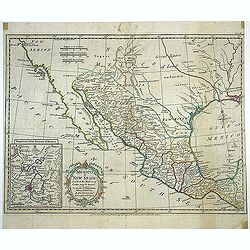
A new map of Mexico or New Spain in which the Motions of Cortes may be traced. . .
Map shows provinces of New Spain, [Baja] California, "New Albion." New Mexico and Louisiana are shown separated by "Great Space of Land unknown." Area...
Date: London, Strahan, T.Cadell, ca. 1777
Selling price: ????
Please login to see price!
Sold in 2013
Amerique septentrionale avec les Routes, Distances en miles, Villages et Etablissements François et Anglois. Par le Docteur Mitchel Traduit de l'Anglois ... Corigee en 1776 par M. Hawkins..
An engraved map in outline color. On eight sheets, each measuring approx. 68 x 46 cm (26¾ x 19¼"), if joined, would form a single large sheet 59 x 79 inches. Backe...
Date: Paris, 1756 /1777
Selling price: ????
Please login to see price!
Sold in 2019
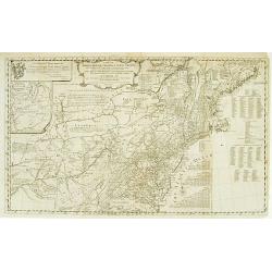
Special Karte von den Mittleren Brittischen Colonien..
Uncommon German map of the east coast of North America. Engraved by T.A.Pingeling. From Bescheibung des brittischen Amerika by Christian Leiste.
Date: Wolfenbüttel 1778
Selling price: ????
Please login to see price!
Sold
Amérique Septentrionale.
Interesting copper-engraved map of North America with Central America, the Caribbean, and parts of South America. Shows large unexplored blank parts in nowadays Western ...
Date: Paris, c1778
Selling price: ????
Please login to see price!
Sold in 2010
CARTE DU CANADA ET DES ETATS-UNIS de l'Amérique Septentrionale Par le S.r ROBERT DE VAUGONDY Geog. Ord.du Roi. . .
A separate issue. This is an updated version of map 1753.2 and one of the first maps to name the United States (Etats-Unis) in the title. Covers Canada east of Lake Super...
Date: Paris, 1778
Selling price: ????
Please login to see price!
Sold in 2012
Il Canada Le Colonie Inglesi Con La Luigiana E Florida di nuouva Projezione...1778.
Map of East coast of America including the Great Lakes. The map makes mention of the upper and lower English Colonies in Louisiana. Ohio here called "Ohio ou alta Lu...
Date: Venise, 1778
Selling price: ????
Please login to see price!
Sold in 2015
Partie de l\'Amerique septent? Qui comprend la nouvelle France. . .
A fine copy of this map of New Foundland, Nova Scotia and the course of the St.Lawrence to Lake Ontario in a fourth state.An inset shows Bellini's famous and important ma...
Date: Paris, 1755-1778
Selling price: ????
Please login to see price!
Sold in 2013
Carte du Theatre de la Guerre actuel entre les Anglais et les Trieze Colonies Unies de l'Amerique Septentrionale dresse par J.B. Eliot
A fine example of J. B. Eliot's map of the United States, in its first state - which is generally regarded as the earliest map to include the title "United States&qu...
Date: Paris, 1778
Selling price: ????
Please login to see price!
Sold in 2015
North America agreeable to the most approved maps and charts. . .
A detailed and uncommon map of North America with the Northwest labeled These Parts Are Entirely Unknown and the notations on the West Coast make various explorers' findi...
Date: London, 1778
Selling price: ????
Please login to see price!
Sold in 2017
Le Colonie Unite dell´America.
Title: 'La Colonie Unite Dell' America Settentrle.' An impressive twelve-sheet map. This is Antonio Zatta's version of John Mitchell's landmark map, with some additional ...
Date: Italy, 1778
Selling price: ????
Please login to see price!
Sold in 2017
Carte du Theatre de la Guerre actuel entre les Anglais et les Trieze Colonies Unies de l'Amerique Septentrionale dresse par J.B. Eliot
A fine example of J. B. Eliot's map of the United States, in its first state of which is generally regarded as the earliest map to include the title "United States''...
Date: Paris, 1778
Selling price: ????
Please login to see price!
Sold
Le Colonie Unite dell America Settentr.le di Nouva Projezione . . .
A complete set of 12 maps that when joined together form a large map of North America. Shows North America west to the Mississippi and Spanish-owned Louisiana, and north ...
Date: Venise, 1778
Selling price: ????
Please login to see price!
Sold in 2019

Le Colonie Unite dell America Settentr. le di Nouva Projezione . . .
A complete set of 12 maps that when joined together form a large map of North America. Shows North America west to the Mississippi and Spanish-owned Louisiana, and north ...
Date: Venise, 1778
Selling price: ????
Please login to see price!
Sold in 2019
La Baja D' HUDSON Terra Di Labrador e Groenlandia con Le Isole Adiacenti.
An excellent, old outlined colored map of Hudson Bay, Baffin Bay, part of Greenland, Labrador and Northern Canada. With marvellous detail on the islands and coastlines, k...
Date: Venice, 1778
Selling price: ????
Please login to see price!
Sold in 2020
IL CANADA Le Colonie Inglesi Con La Luiglana e Florida. Di nuova Projezione.
A striking map of the United States and Canada, which includes references to the Upper and Lower English Colonies of Louisiana. One of the very few maps from the period w...
Date: Venice, 1778
Selling price: ????
Please login to see price!
Sold in 2020
![IL PAESE DE SELVAGGI OUTAGAMIANI, MASCOUTENSI, ILLINESI, E PARTE DELLE VI. NAZIONI. (Fogl. IV.)[Lake Michigan]](/uploads/cache/83526-250x250.jpg)
IL PAESE DE SELVAGGI OUTAGAMIANI, MASCOUTENSI, ILLINESI, E PARTE DELLE VI. NAZIONI. (Fogl. IV.)[Lake Michigan]
A striking and important regional map, bounded by the Missouri River, Lake Michigan and what would ultimately become Michigan in the north and extending south to include ...
Date: Venice, 1778
Selling price: ????
Please login to see price!
Sold in 2020
LA PARTE OCCIDENTALE DELLA NUOVA FRANCIA O CANADA (Fogl. II.)
A striking and detailed map of the region bounded by the Ottawa River and Hudson Bay, drawn from John Mitchell's seminal map. It shows Messesaguesi (Massachusetts) in sou...
Date: Venice, 1778
Selling price: ????
Please login to see price!
Sold in 2020
![IL PAESE DE SELVAGGI OUTAUACESI E KILISTINESI INTORNO AL LAGO SUPERIORE. (Fogl. I.)[LAKE SUPERIOR,FLORIDA&BAHAMAS]](/uploads/cache/83528-250x250.jpg)
IL PAESE DE SELVAGGI OUTAUACESI E KILISTINESI INTORNO AL LAGO SUPERIORE. (Fogl. I.)[LAKE SUPERIOR,FLORIDA&BAHAMAS]
A striking and detailed map of the region the Great Lakes and an inset showing Florida and Bahamas. This map is a part of the Italian edition of John Mitchell's map of th...
Date: Venice, 1778
Selling price: ????
Please login to see price!
Sold in 2020
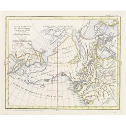
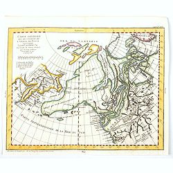
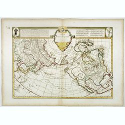
Carte générale des découvertes de l'Admiral de Fonte ..
Based on the map of the northern Pacific, published by Jacques-Nicolas de l'Isle in Paris in 1752. Shows clearly the extraordinary network of channels supposed to link th...
Date: Paris 1779
Selling price: ????
Please login to see price!
Sold
Carte générale des découvertes de l'Admiral de Fonte ..
Based on the map of the northern Pacific, published by Jacques-Nicolas de l'Isle in Paris in 1752. Shows clearly the extraordinary network of channels supposed to link th...
Date: Paris 1779
Selling price: ????
Please login to see price!
Sold
Carte générale des découvertes de l''Amiral de Fonte. . .
Based on the map of the northern Pacific, published by Jacques-Nicolas de l''Isle in Paris in 1752. It shows clearly the extraordinary network of channels supposed to lin...
Date: Paris, 1779
Selling price: ????
Please login to see price!
Sold in 2014
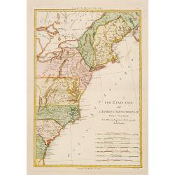
Les États Unis de L'Amerique Septentrionale..
Attractive map covering the Mississippi River and the Great Lakes and Texas region, prepared by R.Bonne and included in his "Atlas Ecyclopédique.."Ri...
Date: Paris 1780
Selling price: ????
Please login to see price!
Sold
Les États Unis de L''Amerique Septentrionale..
Attractive map covering North Americas east coast. Prepared by R.Bonne and included in his "Atlas Ecyclopédique.."Rigobert Bonne (1727-1795) was engi...
Date: Paris 1780
Selling price: ????
Please login to see price!
Sold
Partie du Nord de L'Amerique Septentrionale..
Rigobert Bonne (1727-1795), a prolific French cartographer, flourished between about 1760 and 1778, working in the French Hydrographical Office, and appointed as Hydrogra...
Date: Paris 1780
Selling price: ????
Please login to see price!
Sold
Carte Nouvelle des Posséssions Angloises en Amérique. . .
Third state, of this rare and attractive map shows Eastern Canada and the American colonies. It is important as it gives a clear notion of the international intrigues and...
Date: Paris, Moithey et Crepy, 1780
Selling price: ????
Please login to see price!
Sold in 2018
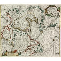
Pascaarte vande Noorder Zee Custen van America, vande West-Hoeck van Ysland doorde Straet Davis en Hudson, tot aen Terra Neuf
Fourth and last edition of van Keulen's chart of the Arctic Canada with the Hudson Bay and the supposed Northwest Passage. First published in 1680. The map is based upon ...
Date: Amsterdam, 1780
Selling price: ????
Please login to see price!
Sold in 2013
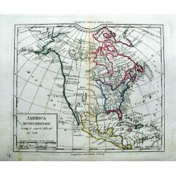
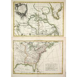
America Settentrionale Secondo le scoperte fatte dal Cap. Cook.
Uncommon italian map of North America. Outlining the United States east of the Mississippi river. With a large New Mexico, Maha Nation, and extensive blank areas in the N...
Date: ca. 1780
Selling price: ????
Please login to see price!
Sold in 2015
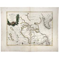
Carte des nouvelles decouvertes au Nord de la Mer du Sud.
The Dezauche edition of Joseph De L'Isle map concentrating on the northern Pacific and showing all of North America and Mexico. While the Russian coastline is shown with ...
Date: Paris, Dezauche, 1780
Selling price: ????
Please login to see price!
Sold in 2023
L'America settentrionale divisa ne' suoi principali stati.
Rare map of North America, from "Atlante Novissimo ad uso Dei Giovani Studiosi Contenuto In Carte XXVII.", published by Giovanni Zempel in Rome, ca. 1780.The ma...
Date: Rome, 1780
Selling price: ????
Please login to see price!
Sold in 2019
Carta Della Florida, Luigiana e Laghi del Canada.
A scarce Italian map of the United States, Florida, Louisiana and Canada, probably issued during the American Revolutionary War. The eastern US is called 'Province Unite'...
Date: Venice, ca 1780
Selling price: ????
Please login to see price!
Sold in 2020
A New and accurate Map of North America, Laid down according to the latest and most approved Observations..
Attractive map of North America showing the claims of the English, French and Spanish distinguished by early hand color. English bias is evident as the border reaches to ...
Date: London 1747 -1781
Selling price: ????
Please login to see price!
Sold
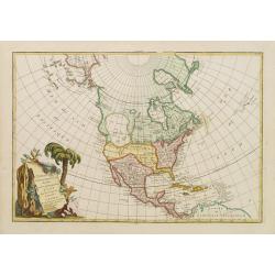
L'Amerique Septentrionale divisé en fes principaux.
A finely engraved map of North America, prepared by Janvier. The map is most notable for it's depiction of Mer de L'Quest or Sea of the West, a great sea, easily the size...
Date: Paris 1782
Selling price: ????
Please login to see price!
Sold
Amerique Septentrionale
Charming map of early North America including Central America and the West Indies. Filled with place names, Indian locations, and topographical information such as rivers...
Date: Paris 1782
Selling price: ????
Please login to see price!
Sold in 2008
L'AMERIQUE SEPTENTRIONALE divisee en ses principaux Etats.
A fine example of Janvier's map of North America to illustrate the sea of the west "Mer ou Baye de l'Ouest", prior to the incorporation of information from Cook...
Date: Paris, 1782
Selling price: ????
Please login to see price!
Sold in 2017
![L'AMERIQUE SEPTENTRIONALE divisee en ses principaux ETATS, 1782.[Great Western Sea]](/uploads/cache/82628-250x250.jpg)
L'AMERIQUE SEPTENTRIONALE divisee en ses principaux ETATS, 1782.[Great Western Sea]
A fine example of Janvier's map of North America to illustrate the sea of the west. "Mer ou Baye de l'Ouest", prior to the incorporation of information from Coo...
Date: Paris, 1782
Selling price: ????
Please login to see price!
Sold in 2019
Amérique Septentrionale avec les Nouvelles Découvertes fait au Nord, par les Russes et les Anglois..
Rare map of North America, showing a remarkable NW Coast of America, including the recently discovered sea (by the Russians) of the West. The NW Coast and area near Canad...
Date: Paris, 1783
Selling price: ????
Please login to see price!
Sold
La Virginie, Pennsilvanie, Nouvelle Angleterre, et autres Pays fesant partie des Possessions Angloises, en Amérique..
Rare map, extending from Maine to the Chesapeake and west to include Lake Michigan. A boundary line confines the English colonies to the coast. F. Duquene is named along ...
Date: Paris, 1783
Selling price: ????
Please login to see price!
Sold
Partie Méridionale des possessions Angloises en Amérique..
Rare map of the South, showing the regions east of the Mississippi and extending North to Virginia and Kentucky. The map is filled with place names, Indian villlages, ear...
Date: Paris, 1783
Selling price: ????
Please login to see price!
Sold
CARTE DES ETATS-UNIS D'AMÉRIQUE, et du Cours du Mississipi..
First state of three with changed date and imprint. It was first published in 1783 by Desnos, then by Esnauts et Rapilly and was re-issued in 1787. This map composed by B...
Date: Paris 1783
Selling price: ????
Please login to see price!
Sold
Partie de L'Amerique Septentrionale qui comprend le Canada, la Louisiana, le Labrador, le Groenland, les Etats-Unis et la Floride
Jean Lattré, Paris-based engraver and publisher. Worked with Robert de Vaugondy, J. Janvier and R. Bonne. " Atlas Monderne', 1771, 1783 , 1793. Rigobert Bonne (1727...
Date: Paris, 1783
Selling price: ????
Please login to see price!
Sold

