Browse Listings in America > North America > North Pole
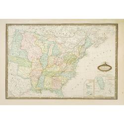
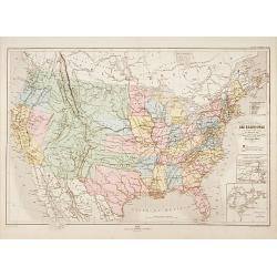
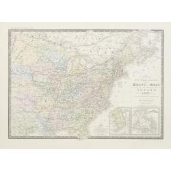
États-Unis de L'Amérique du Nord..
Very detailed map from "Atlas Spherodidal & Universel de geographie", Prepared by F.A.Garnier and edited by Jules Renouard, rue de Tournon, Paris. Uncommon ...
Date: Paris, 1861
Selling price: ????
Please login to see price!
Sold
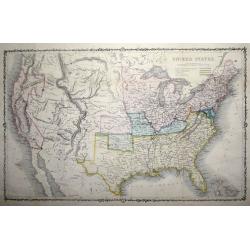
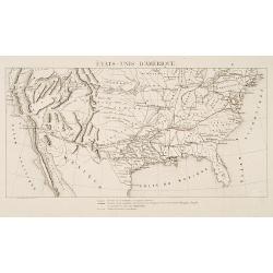
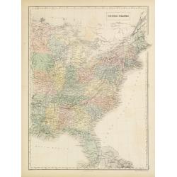
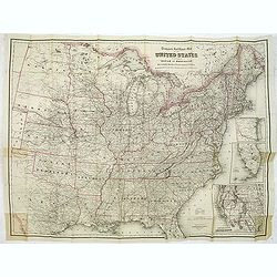
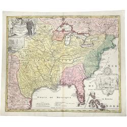
United States.
An uncommon pre-Civil War issue that was published by the London Printing and Publishing Company. Circa 1861.A highly detailed map which covers the entire country, issued...
Date: London 1861
Selling price: ????
Please login to see price!
Sold in 2015
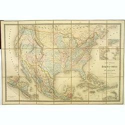
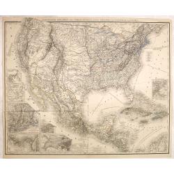
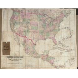
Carte Générale Des Etats - Unis Et Du Mexique Comprenant L'Amerique Centrale Et Les Antilles.
Large folding-map of the United States, Mexico and West Indies, with inset maps of Central America, Lesser Antilles, New York and Long Island, and the Atlantic connection...
Date: Paris, 1862
Selling price: ????
Please login to see price!
Sold in 2019
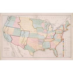
Verein-Staaten von Nord-America . . .
General map of the United States of America with inset map of Texas. Very detailed map with a color key to American States.Published in Stieler's Hand Atlas.
Date: Gotha, 1862
Selling price: ????
Please login to see price!
Sold in 2011
Vereinigte Staaten von Nord Amerika, nebst Mexico..
Uncommon map United States, with inset maps of San Francisco, German settlement Wartburg near Kingston, New England, Panama, New York, and Boston, including the Great Lak...
Date: Leipzig, 1863
Selling price: ????
Please login to see price!
Sold in 2018
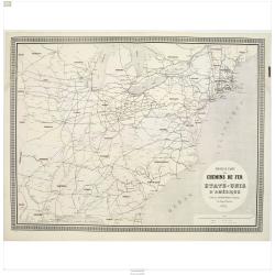
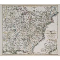
Nouvelle carte des chemins de fer des Etats-Unis d'Amerique
Fine map of eastern part of the United States, showing the early railway system of the area. From Atlas des Chemins de Fer published by Napoléon Chaix and printed by Imp...
Date: Paris 1863
Selling price: ????
Please login to see price!
Sold in 2011

(Vereinigte Staaten von Nord Amer)ika, nebst Mexico und Central America
The right hand part of an uncommon map of the United States, German settlement Wartburg near Kingston, inset plan of Boston, including the Great Lakes area. With color-ke...
Date: Leipzig, 1863
Selling price: ????
Please login to see price!
Sold in 2011
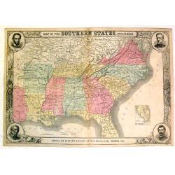
Map of the Southern States, Including Rail Roads, County Towns, State Capitals, County Roads, The Southern Coast From Delaware to Texas, Showing the Harbors, inlets, Forts and Position of Blockading Ships
Fine Harper's map of the South from Virginia and Florida to Kansas and Texas. The map features portraits of Lincoln, McClellan, Seward and Scott in the corners. Also a de...
Date: New York, 1863
Selling price: ????
Please login to see price!
Sold in 2015
Die Vereinigten Staaten von Amerika aus der Vogelschau.
From the "Illustrierte Zeitung", a rere map of the United States appeared in 1863. It shows the "sclaven Staaten" as well as the train roads. Rare
Date: Germany, 1863
Selling price: ????
Please login to see price!
Sold in 2017
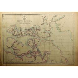
The Arctic Regions of North America.
A highly detailed map of the far north of America from Bankes Strait through Baffin Bay, by Edward Weller, for the Weekly Dispatch Atlas. With an inset "Continuation...
Date: London, 1863
Selling price: ????
Please login to see price!
Sold in 2019
Amerique du Nord.
Fine steel engraved map of North America and the Caribbean. It is interesting to fix the time of this map - The United States was involved in the Civil War,Canada was not...
Date: Paris, 1864
Selling price: ????
Please login to see price!
Sold in 2015
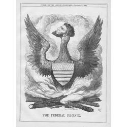
A set of 13 humorous Punch prints dated 1846 1860, 1862, 1863, 1864. All with American, Civil War, Oregon Treaty and Abraham Lincoln interest
Mostly engraved by Sir John Tenniel, Richard Doyle and Joseph Swain. Sir John Tenniel was one of the most important wood engravers of his time. Punch was responsible for ...
Date: London, 1846 - 1864
Selling price: ????
Please login to see price!
Sold in 2015

A set of 12 humorous prints. 1846, 1850, 1856, 1862, 1863, 1864, 1865. All with American, Civil War, Oregon Treaty and Abraham Lincoln interest
A set of 12 humorous prints. 1846, 1850, 1856, 1862, 1863, 1864, 1865. Mostly engraved by Sir John Tenniel, Richard Doyle and Joseph Swain. Sir John Tenniel was one of th...
Date: London, 1846 - 1865
Selling price: ????
Please login to see price!
Sold in 2016

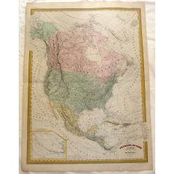
Map of the United States of North America.
A detailed map of the U.S. published at the end of the American Civil War in London by James Wyld. Each state is colored differently, rivers, major settlements and native...
Date: London, ca 1865
Selling price: ????
Please login to see price!
Sold in 2020

A set of 15 humorous prints. 1846, 1856, 1862, 1863, 1864, 1865, 1866. All with American, Civil War, Oregon Treaty and Abraham Lincoln interest
A set of 15 humorous prints. 1846, 1856, 1862, 1863, 1864, 1865, 1866. All with American, Civil War, Oregon Treaty and Abraham Lincoln interest.Mostly engraved by Sir Joh...
Date: London, 1846 - 1866
Selling price: ????
Please login to see price!
Sold in 2015
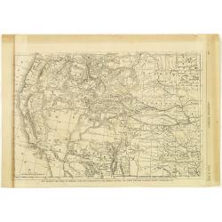
Map Showing the Scene of General Hancocks Operations in the Indian Country, the Forts, military stations, Pacific railroads etc.
A full-page map from Harper's Weekly that is very well engraved and detailed considering it is from a weekly newspaper. The subject of the map is General Hancock's operat...
Date: New York, 1867
Selling price: ????
Please login to see price!
Sold in 2012
Carte physique et politique des États-Unis..
Very detailed map of the United States. In lower right inset maps of the Great Lakes and the River Niagara.Engraved by Th.Gobert and Langevin. Included in Atlas Général...
Date: Paris, 1870
Selling price: ????
Please login to see price!
Sold in 2014
États-Unis D'Amérique.
Rare map of the United States showing the existing roads, the existing roads owned by the Compagnie Transcontinentale Memphis-Pacific and the planned roads of the same co...
Date: Paris 1870
Selling price: ????
Please login to see price!
Sold
Colton's Map of the United States of America The British Provinces, Mexico and the West Indies, Showing the Country from the Atlantic to the Pacific Oceans.
Large folding map of the United States. Dissected and mounted onto linen in 60 sections. Original linen backing with original slip case. Published by G W & C B Colton...
Date: New York 1870
Selling price: ????
Please login to see price!
Sold in 2013
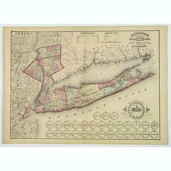
Putnam, Rockland, Westchester, New York, Richmond, Kings, Queens, and Suffolk Counties.
A detailed map of counties encompassing metropolitan New York City. The map highlights Putnam, Rockland and Westchester Counties, New York City, and, most prominently, Lo...
Date: New York, 1872
Selling price: ????
Please login to see price!
Sold in 2019
United States.
A detailed lithographed map of the United States. Published by Adam (1784-1874) and Charles Black, publishers active in Edinburgh. Engraved by S.Hall Bury, Bloomsbury. °
Date: Edinburg, 1874
Selling price: ????
Please login to see price!
Sold in 2011
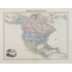
Amérique Septentrionale.
Decorative map of North America from Géographie Universelle, Atlas Migeon. With an engraving lower left corner of the Niagara Falls. Published by J. Migeon. From one of ...
Date: Paris, 1874
Selling price: ????
Please login to see price!
Sold
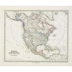
Nord-America. Entworfen u. gezeichnet von F. von Stülpnagel.
Large and detailed steel engraving showing North and Central America as well as the Caribbean.Published in Stieler's Hand Atlas.Texas named.
Date: Gotha, 1875
Selling price: ????
Please login to see price!
Sold in 2017
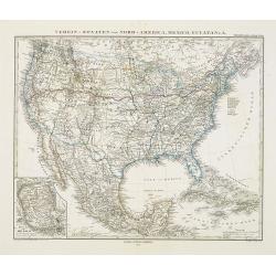
Verein-Staaten von Nord-America, Mexico, Yucatan..
Very detailed map of the United States of America showing the Caribbean. With an inset map of the surrounding area of Mexico city. Details of towns, forts, topo., railroa...
Date: Gotha, 1875
Selling price: ????
Please login to see price!
Sold in 2020
Carte de la region orientale des Éts-Unis et de la dominion du Canada.
Detailed map of The United States of America and Canada, with in lower right corner inset maps of Florida and Newfoundland.Prepared by A.Brué, re-edited by E.Levasseur a...
Date: Paris, 1876
Selling price: ????
Please login to see price!
Sold in 2020
Travelers' Rail Road Map of the United States to Accompany ‘Boston to Washington' Riverside Series Centennial Guides. . .
Lithographed folding map with excellent original outline hand color for state boundaries. 28 1/4 x 38" at neat line. Sheet size: 30 x 39 1/4". Three inset maps ...
Date: New York, G. W. & C. B. Colton & Co., 1876
Selling price: ????
Please login to see price!
Sold in 2014
Carte Ecclésiastique des Etats Unis d'Amérique.
Uncommon map of the United States divided up in 11 missionary regions, including on the right side a list of the total population, Catholics, priests and the number of ch...
Date: Lyon/ Paris 1877
Selling price: ????
Please login to see price!
Sold
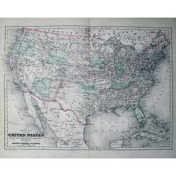
Map of the United States Drawn and Engraved on Copper-Plate Expressly for Johnson's Universal Cyclopaedia.
Fine map of the United States. Oklahoma is Indian Territory and only "one" Dakota. With many place names, railroads, etc.
Date: New York, c1880
Selling price: ????
Please login to see price!
Sold in 2013

The Steam-Ship Alaska.
A fine Currier & Ives chromolithographic print featuring the steam-ship Alaska of the Guion Line. Its nickname was "THE GREYHOUND OF THE ATLANTIC." This pri...
Date: New York, ca. 1880
Selling price: ????
Please login to see price!
Sold in 2016
Oro-Hydrographische Kaart van Noord-Amerika.
One of the earliest thematic maps of North America published in the Netherlands from "Atlas der natuurkundige aardrijkskunde. . .". prepared by Nicolaas Wilhelm...
Date: Amsterdam, C.L. Brinkman, 1883
Selling price: ????
Please login to see price!
Sold in 2018

Eight volumes, ' Narrative and Critical History of America ' by Justin Winsor, complete, published by Houghton, Mifflin & Co. Boston at the Riverside Press 1889
In addition to the set in volume, I is a handwritten letter dated July 7th, 1893, signed Edward Channing, an American historian, and author of a monumental "History ...
Date: Boston, 1889
Selling price: ????
Please login to see price!
Sold in 2017
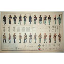
ATLAS TO ACCOMPANY THE OFFICIAL RECORDS OF THE UNION AND CONFEDERATE ARMIES 1861 - 1865
A highly desirable, rarely found double page lithograph of official Union and Confederate army uniforms, along with chevrons, buttons, badges, caps and more. A fascinatin...
Date: New York, c. 1890
Selling price: ????
Please login to see price!
Sold
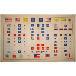
ATLAS TO ACCOMPANY THE OFFICIAL RECORDS OF THE UNION AND CONFEDERATE ARMIES, 1861-1865
An impressive and rarely seen double-page lithographic print of official U.S. Civil War-era national and military standards, badges, and icons. More than 100 items are de...
Date: New York, ca. 1894
Selling price: ????
Please login to see price!
Sold
Map of North America.
Attractive map of North America during the late 19th century. With the Indian Territory north of Texas. Indicates coal fields, and shows railways.
Date: New York, 1894
Selling price: ????
Please login to see price!
Sold in 2015
Guerre Hispano-Américaine.. Carte de Cuba, des petites Antilles et des Iles Philippines.
Interesting map of North and Central America. In upper right corner: 2e édition Revue et Completée. Text on verso relating to the history of Cuba Histoire de Cuba depui...
Date: Gent , 1898
Selling price: ????
Please login to see price!
Sold
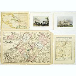
Group of 5 maps and prints of North American interest.
Group of five prints and maps. - Map of the West Indies by W.Darton.- View of New York from Weehawken by W.H.Bartlett (120x180mm.)- Principal front of the capitol Washing...
Date: c. 1850-1900
Selling price: ????
Please login to see price!
Sold in 2014
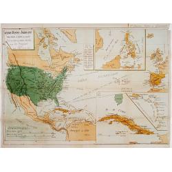
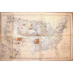
Map Showing Indian Reservations Within The Limits of the United States Compiled Under The Direction of the Hon. T. J. Morgan Commissioner of Indian Affairs 1901.
Fine example of the Indian Affairs Commissioner's Map of the United States. The present map locates all the lands reserved to Native American Tribes as of 1901.Inset maps...
Date: Washington D.C, 1901
Selling price: ????
Please login to see price!
Sold in 2017
![[North America]](/uploads/cache/25596-250x250.jpg)
[North America]
A more than 100 year old Russian map of North America printed in lithography. Published by one of the most successful publishers of St. Petersburg A.Iljin. With a color k...
Date: St. Petersburg, c.1905
Selling price: ????
Please login to see price!
Sold in 2013
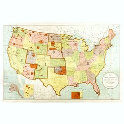
Map Showing Indian Resevations Within the Limits of the United States.
Fine, large chromolithograph map showing American Indian Reservations after the turn of the century. It was compiled under the direction of the Honorable R.G. Valentine, ...
Date: Wahington, 1910
Selling price: ????
Please login to see price!
Sold in 2016
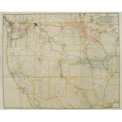
Map showing Great Northern Railway System..
Map of the rail way routes of the railway systems throughout the northern parts of the United States.
Date: Chicago & New York, 1915
Selling price: ????
Please login to see price!
Sold
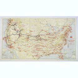
Military Map of the United States / Illustrated Gettysburg Battlefield Map.
The first map of this pair is an attractive general map of the USA Issued by the Union Pacific Railroad during WWII, pictorially showing all the Naval Bases, Army Camps, ...
Date: Chicago, 1942 - Pennsylvannia, 1932
Selling price: ????
Please login to see price!
Sold in 2019
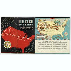
United Airways. A Gay Geography of the Main Line Airway.
A unique United Airlines Booklet, with original wrappers, with color illustrations on each page with pictographic / pictorial maps (16 pages including covers). It is high...
Date: U.S.A., 1938
Selling price: ????
Please login to see price!
Sold in 2020
![A Pictorial Map of North America. [signed by Ernest Dudley Chase]](/uploads/cache/38841-250x250.jpg)
A Pictorial Map of North America. [signed by Ernest Dudley Chase]
Signed example of Ernest Dudley Chase's pictorial map of North America.According to Rumsey: Pictorial map of the North American continent, from Greenland in the north to ...
Date: Winchester, 1945
Selling price: ????
Please login to see price!
Sold in 2017
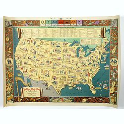
Folklore Music Map of the United States.
A terrific, and unusual, fully colored lithographic map of the Folklore Map of The United States, by Dorothea Dix, and published by the Hagstrom Company Inc of New York i...
Date: New York, 1945
Selling price: ????
Please login to see price!
Sold in 2018
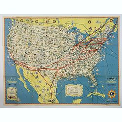
American Airlines Systems Map.
A striking, large poster, or pocket map of American Airlines flagship routes in relation to the air transport system of the United States. Routes flown also include parts...
Date: New York, 1945
Selling price: ????
Please login to see price!
Sold in 2019
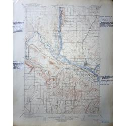
A set of 60 United States Department of the Interior Geological Survey Topographic Maps
The image shown is for Pasco Washington Quadrangle , most are Oregon, Washington and Idaho.The scale is 2 miles to the inch. Many have hand script descriptions in the mar...
Date: 1906 – 1947
Selling price: ????
Please login to see price!
Sold in 2016
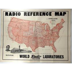
Radio Reference Map.
An interesting advertising map for 'WORLD RADIO LABORATORIES', “The World’s Largest Distributors of Amateur Radio transmitting Equipment”. It shows the monitoring s...
Date: Council Bluffs, 1947
Selling price: ????
Please login to see price!
Sold in 2018
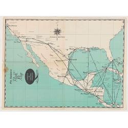
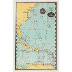
Pan American Flight Map - Mexico & Central America.
Pan American Airlines Flight Map of Mexico & Central America from the mid 1950's.
Date: United States, ca 1950
Selling price: ????
Please login to see price!
Sold in 2020
Pan American Flight Map - Mexico & Central America.
Pan American Airlines Flight Map of Mexico & Central America from the mid 1950's.
Date: United States, ca 1950
Selling price: ????
Please login to see price!
Sold in 2020
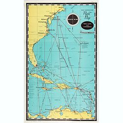
Pan American Airways New York - Caribbean.
Pan American Airlines Flight Map of New York to Caribbean from the mid 1950's.
Date: United States, ca. 1950
Selling price: ????
Please login to see price!
Sold in 2021
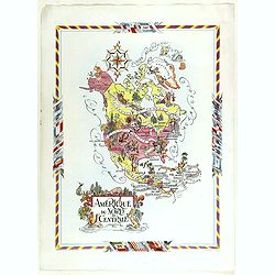
Amérique du Nord et Centrale.
color printed pictorial map of North and Central America, with decorative title cartouche and borders, depict countries, regions, major cities, industries, agriculture, I...
Date: Paris, 1951
Selling price: ????
Please login to see price!
Sold in 2018
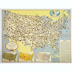
Carte Illustree des Etats-Unis d'Amerique Principaux produits, resources regionales, et particularites physiques.
A decorative French map of the United States' main products, regional resources and physical features. The map is covered with many small pictorial vignettes highlighting...
Date: Washington D.C., ca. 1965
Selling price: ????
Please login to see price!
Sold in 2018

Ronald Reagan.
Original drawing representing a caricature of Ronald Reagan.Born in 1958, Jan Op De Beeck was elected in 2003 as 'World's Best Caricaturist' by the Professional cartoonis...
Date: Belgium, 1987
Selling price: ????
Please login to see price!
Sold
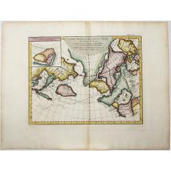
Carte Generale des Decouvertes de l'Amiral de Fonte, . . (Explorers)
An interesting map of the NW Coast of America and the NE Coast of Asia, based upon Jefferys map of 1768. Prior to Cook's 1st Voyage, the English, French and Russians were...
Date: Paris, 1770ca
Selling price: ????
Please login to see price!
Sold in 2020
Amplissimae Regionis MISSISSIPI Seu Proninciae Ludovicianae.
A striking hand-colored example of Homann's map of the Course of the Mississippi River, based upon the reports of Hennepin, who explored the upper Mississippi and Great L...
Date: Nuremberg, ca 1720
Selling price: ????
Please login to see price!
Sold in 2019
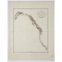
Carte de la partie de la Cote nord-ouest de l' Amerique.
A detailed and rare map of the Gulf of Alaska, British Columbia, and south to St.Francisco. Prepared by Edward Roberts after information by George Vancouver and engraved ...
Date: Paris, ca. 1800
Selling price: ????
Please login to see price!
Sold in 2017
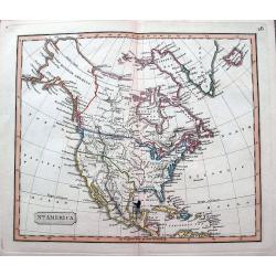
North America.
An interesting steel engraved map showing Mexico reaching until Mendocino and Utah Lake! Locates Texas, Cabo San Lucas, New Madrid in Missouri, etc. Names Indian nations,...
Date: Anon, ca 1820?
Selling price: ????
Please login to see price!
Sold in 2018

Washinga Sahba's Grab.../ Tombeau de Wachinga Sahba.../ Washinga Sahba's Grave on Blackbird's Hill.
Aquatint from: 'Reise in das innere Nord-America in den Jahren 1832-1834' by Prince Maximilian of Wied-Neuwied, after paintings by Karl Bodmer, engraved by Lucas Weber, p...
Date: London, 1842
Selling price: ????
Please login to see price!
Sold in 2016

