Browse Listings in America > North America > North Pole
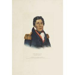
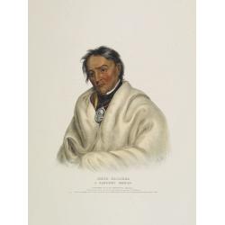
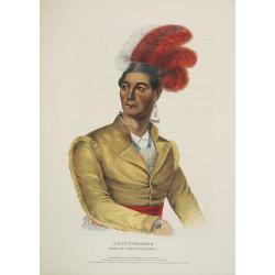
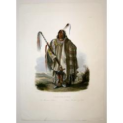
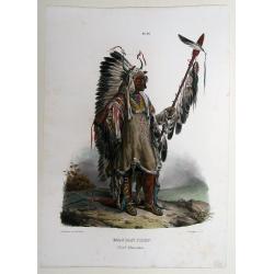
Push-Ma-Ta-Ha a Choctaw warrior.
This hand-colored lithograph of Pushmataha (ca. 1764-5 - 1824) (Choctaw), was a warrior noted for his vengeance on other Native Americans, notably Creeks and Seminoles, a...
Date: Philadelphia, circa 1836-1842
Selling price: ????
Please login to see price!
Sold in 2008
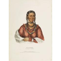
Hayne-Hudjihini the eagle of delight.
This hand-colored lithograph of Hayne-Hudjihini the eagle of delight, one of only eight women whose portraits appeared in this book. By contrast there were 111 men's port...
Date: Philadelphia, circa 1836-1842
Selling price: ????
Please login to see price!
Sold in 2008

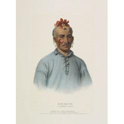
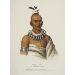
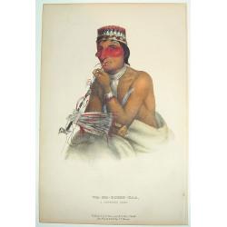
Tens-Kwau-Ta-Waw - The prophet.
A beautifully defined lithograph of a half-length portrait of Tenskwautawaw with right eye closed, wearing earrings, silver armband and necklace, red sash across his ches...
Date: Philadelphia, circa 1836-1842
Selling price: ????
Please login to see price!
Sold in 2019

Tens-Kwau-Ta-Waw - The prophet.
A beautifully defined lithograph of a half-length portrait of Tenskwautawaw with right eye closed, wearing earrings, silver armband and necklace, red sash across his ches...
Date: Philadelphia, circa 1836-1842
Selling price: ????
Please login to see price!
Sold in 2008

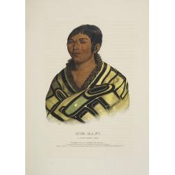
Chippeway Squaw & Child.
A beautifully defined lithograph of a Chippeway squaw and child, facing left. The woman is walking with head down, arms in blue blanket around her shoulders, child in car...
Date: Philadelphia, circa 1836-1842
Selling price: ????
Please login to see price!
Sold in 2008
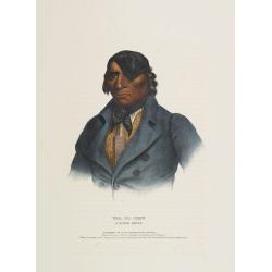
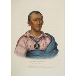
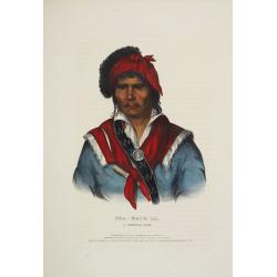
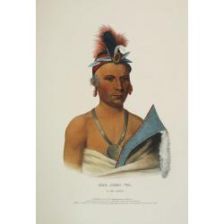
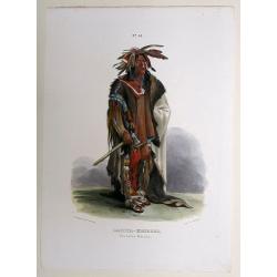
Kish-Kal-Wa. A Shawanoe chief.
A beautifully defined lithograph of a half-length portrait of Portrait of Kish Kal Wa, Shawanoe Chief. From McKenney & Hall's History of the Indian Tribes, perhaps th...
Date: Philadelphia, circa 1836-1842
Selling price: ????
Please login to see price!
Sold in 2008

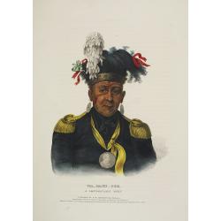
Red-Jacket A Seneca War chief.
A beautifully defined lithograph of a half-length portrait of the famous Seneca Indian Chief Red Jacket wearing his large-size, silver, oval 1792 Washington Peace Medal, ...
Date: Philadelphia, circa 1836-1842
Selling price: ????
Please login to see price!
Sold in 2008
Waa-Pa-Shaw. A Sioux Chief.
A beautifully defined lithograph of a half-length portrait of Waa-Pa-Shaw, better known as Wabasha, he was chief of a Kiowa tribe of the Mdewakanton Sioux. He was treated...
Date: Philadelphia, circa 1836-1842
Selling price: ????
Please login to see price!
Sold in 2008
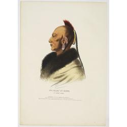
Meta-Koosega. A chippeway warrior.
A beautifully defined lithograph of a half-length portrait of Meta-Koosega wearing an Indian Peace Medal, a blanket and black cravat. Disbound from McKenney and Hall's Hi...
Date: Philadelphia, circa 1836-1842
Selling price: ????
Please login to see price!
Sold in 2008
Wat-Che-Mon-Ne, an Ioway Chief.
A beautifully defined lithograph of Wat-Che-Mon-Ne, an Ioway Chief from McKenney & Hall's History of the Indian Tribes, perhaps the most important work ever published...
Date: Philadelphia, circa 1836-1842
Selling price: ????
Please login to see price!
Sold in 2008
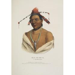
Mar-Ko-Me-Te, a Menomene brave.
A beautifully defined lithograph of Mar-Ko-Me-Te, a Menomene brave from McKenney & Hall's History of the Indian Tribes, perhaps the most important work ever published...
Date: Philadelphia, circa 1836-1842
Selling price: ????
Please login to see price!
Sold in 2008
Le Soldat du Chene, an Osage Chief.
A beautifully defined lithograph of "Le Soldat du Chene, an Osage Chief " from McKenney & Hall’s History of the Indian Tribes, perhaps the most important ...
Date: Philadelphia, circa 1836-1842
Selling price: ????
Please login to see price!
Sold in 2008
Stum-Ma-Nu, a Flat-Head boy.
A beautifully defined lithograph of Stum-Ma-Nu, a Flat-Head boy from McKenney & Hall's History of the Indian Tribes, perhaps the most important work ever published on...
Date: Philadelphia, circa 1836-1842
Selling price: ????
Please login to see price!
Sold in 2008
Nea-Math-La, a Seminole Chief.
A beautifully defined lithograph of Nea-Math-La, a Seminole Chief from McKenney & Hall's History of the Indian Tribes, perhaps the most important work ever published ...
Date: Philadelphia, circa 1836-1842
Selling price: ????
Please login to see price!
Sold in 2008
Ahyouwaighs, Chief of the Six Nations.
A beautifully defined lithograph of Ahyouwaighs, Chief of the Six Nations from McKenney & Hall's History of the Indian Tribes, perhaps the most important work ever pu...
Date: Philadelphia, circa 1836-1842
Selling price: ????
Please login to see price!
Sold in 2008
Tai-O-Mah, a Musquakee brave.
A beautifully defined lithograph of Tai-O-Mah, a Musquakee brave from McKenney & Hall's History of the Indian Tribes, perhaps the most important work ever published o...
Date: Philadelphia, circa 1836-1842
Selling price: ????
Please login to see price!
Sold in 2008
Kee-Shes-Wa, a Fox Chief.
A beautifully defined lithograph of Kee-Shes-Wa, a Fox Chief from McKenney & Hall's History of the Indian Tribes, perhaps the most important work ever published on No...
Date: Philadelphia, circa 1836-1842
Selling price: ????
Please login to see price!
Sold in 2008
Wa-Baun-See, a Pottawatomie Chief.
A beautifully defined lithograph of Wa-Baun-See, a Pottawatomie Chief from McKenney & Hall's History of the Indian Tribes, perhaps the most important work ever publis...
Date: Philadelphia, circa 1836-1842
Selling price: ????
Please login to see price!
Sold in 2008
Le Soldat du Chene, an Osage Chief.
A beautifully defined lithograph of "Le Soldat du Chene, an Osage Chief " from McKenney & Hall’s History of the Indian Tribes, perhaps the most important ...
Date: Philadelphia, circa 1836-1842
Selling price: ????
Please login to see price!
Sold in 2011
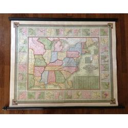
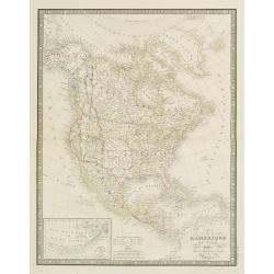
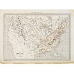
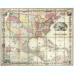
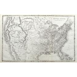
Mitchell's National Map of the American Republic or United States of North America Together with Maps of the Vicinities of Thirty -Two of the Principal Cities and Towns in the Union
Mitchell's National Map of the American Republic or United States of North America drawn by J.H. Young and engraved by J.H. Brightly. Map extends into the eastern part of...
Date: 1843
Selling price: ????
Please login to see price!
Sold in 2013
Pehriska-Ruhpa.
Aquatint from: 'Reise in das innere Nord-America in den Jahren 1832 - 1834' by Prince Maximilian of Wied-Neuwied, after paintings by Karl Bodmer, engraved by Paul Legrand...
Date: Paris, 1837-1843
Selling price: ????
Please login to see price!
Sold in 2015
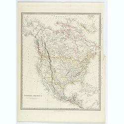
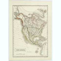
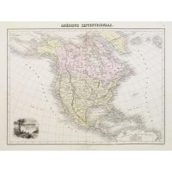
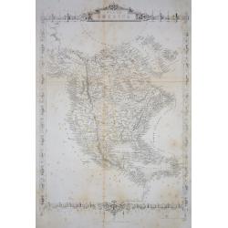
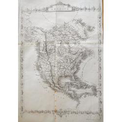
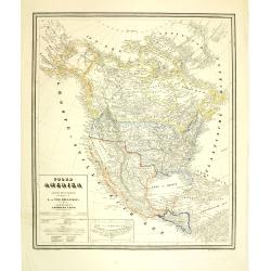
North America.
A detailed map of North America, published by Charles Knight in London for the S.D.U.K. Country borders are in different outline colors, TX is seen as a republic. Map ext...
Date: London ca 1843
Selling price: ????
Please login to see price!
Sold in 2019
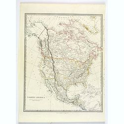
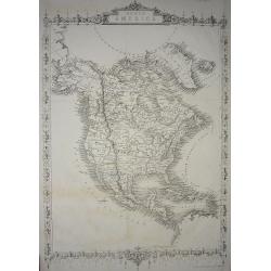
North America.
A detailed map of North America, published by Charles Knight in London for the S.D.U.K. Country borders are in different outline colors, TX is seen as a republic. Map ext...
Date: London ca 1843
Selling price: ????
Please login to see price!
Sold in 2019
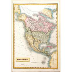
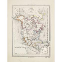
North America.
This interesting transition map features Alaska as a part of Russia, California and Texas as a part of Mexico and Canada still "British Territories". Sidney H...
Date: London, 1844
Selling price: ????
Please login to see price!
Sold in 2013
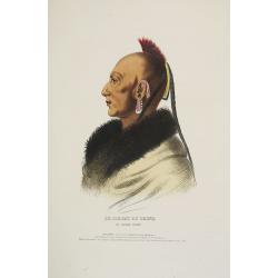
Mandan Chef. / Chef Mandan.
Original lithograph by J. Honegger, after an aquarell by Karl Bodmer, for Maximilian Prinz zu Wied's': "Reise in das innere Nord-America in den Jahren 1832 bis 1834&...
Date: Zurich, 1845
Selling price: ????
Please login to see price!
Sold in 2015
Dacota-Krieger./ Guerrier Dacota.
Original lithograph by J. Honegger, after an aquarell by Karl Bodmer, for Maximilian Prinz zu Wied's's: “Reise in das innere Nord-America in den Jahren 1832 bis 1834”...
Date: Zurich, 1845
Selling price: ????
Please login to see price!
Sold in 2015
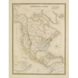
North America.
Sidney Hall's map of North America, showing Texas as a republic. Other interesting facts are that Alaska is still Russian Territory, Canada stretches down 'Western Territ...
Date: London, ca 1845
Selling price: ????
Please login to see price!
Sold in 2020
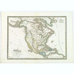
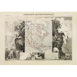
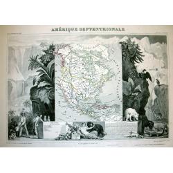
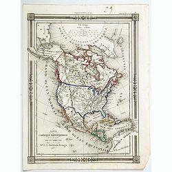
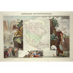
Amérique septentrionale.
An uncommon map of North America prepared by N.Lorrain, who worked for Dépot de la Guerre. Showing the state of Texas as a republic. Mexico occupied the south west, and ...
Date: Paris, 1845
Selling price: ????
Please login to see price!
Sold in 2020
![DIE VEREINIGTEN STAATEN VON NORD-AMERICA .. 1846 [Texas Republic]](/uploads/cache/85591-250x250.jpg)
DIE VEREINIGTEN STAATEN VON NORD-AMERICA .. 1846 [Texas Republic]
Rare late edition of Streit's fascinating map of the United States with inset maps of the region around Washington DC, Boston, Philadelphia, and New York. Very nice detai...
Date: Leipzig, 1846
Selling price: ????
Please login to see price!
Sold in 2021
Amerique Septentrionale.
Beautiful map with the United States.
Date: Paris, 1847
Selling price: ????
Please login to see price!
Sold in 2017
Amerique Septentrionale.
A beautiful map with the United States with Texas as a republic, and extending into present day Canada, Russia in control of Alaska, and Mexico's northern border defined ...
Date: Paris, 1847
Selling price: ????
Please login to see price!
Sold in 2017
Amerique Septentrionale.
Beautiful map with the United States extending into present day Canada, Russia in control of Alaska and Mexico's northern border according to the Treaty of 1810. Surround...
Date: Paris, 1847
Selling price: ????
Please login to see price!
Sold in 2019
North America.
Published by Chapman and Hall from "Sharpe's Corresponding Maps".
Date: London, 1848
Selling price: ????
Please login to see price!
Sold in 2019
Amérique Septentrionale.
A very decorative map with the United States extending into present day Canada, Russia in control of Alaska and Mexico's northern border according to the Treaty of 1810. ...
Date: Paris 1850
Selling price: ????
Please login to see price!
Sold
Amérique Septentrionale.
A nice map of the continent showing the national boundaries, but not the individual states and provinces.The United States is shown with its boundary with Canada complete...
Date: Paris 1850
Selling price: ????
Please login to see price!
Sold
![Opperhoofd der Vos Indiaanen. [Fox indians]](/uploads/cache/23391-250x250.jpg)
Opperhoofd der Vos Indiaanen. [Fox indians]
Decorative, hand colored, woodcut engraving illustrating the chief of the Fox Indian tribe.After a war with the Illinois (c.1765), the Fox moved into Illinois territory. ...
Date: Amsterdam, ca. 1850
Selling price: ????
Please login to see price!
Sold in 2016
Groep van Raven-Indiaanen.
Decorative, original hand colored, woodcut engraving illustrating a group of Native Americans belonging to the Raven tribe.
Date: Amsterdam, ca. 1850
Selling price: ????
Please login to see price!
Sold in 2016
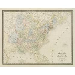
Carte des Etats-Unis d''''Amérique comprenant une Partie des Districts de l''''Ouest et de la Nouvelle Bretagne..
Map of the states east of the Mississippi and the adjacent Indian Territories to the west. Texas is shown as a separate state.Relief shown by hachures. From the Atlas cl...
Date: Paris, 1850
Selling price: ????
Please login to see price!
Sold in 2020
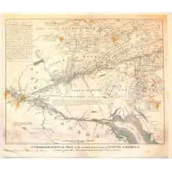
A Chorographical Map of the Northern department of North America.
A detailed map of the United States and Canada showing Lake Ontario and the St. Lawrence River at the bottom with New Hampshire at the top. This is a smaller edition of a...
Date: New Haven, 1850
Selling price: ????
Please login to see price!
Sold in 2015
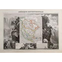
Amérique Septentrionale.
Important French map of North America, showing Texas as an independent republic. The population table lists Texas with 200.000 and the United States with 19.000.000 inha...
Date: Paris, ca. 1850
Selling price: ????
Please login to see price!
Sold in 2018
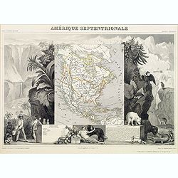
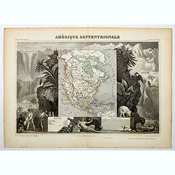
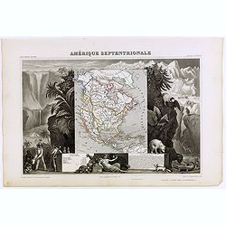
Amerique Septentrionale.
A beautiful map of the United States with Texas as a Republic, and extending into present day Canada, Russia in control of Alaska, and Mexico's northern border defined ac...
Date: Paris, ca 1850
Selling price: ????
Please login to see price!
Sold in 2018
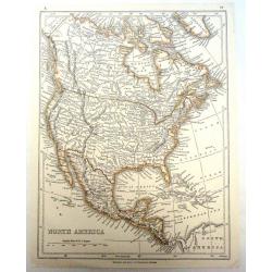
United States, East..
A delightful small map of the eastern portion of the United States, by Alfred Adlard, published in his Vignette Modern School Atlas of the World. When looking at this map...
Date: London, 1850
Selling price: ????
Please login to see price!
Sold in 2020
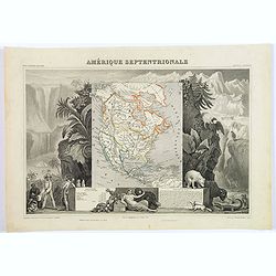
Amérique Septentrionale.
An important French map of North America, showing Texas within Mexico. The population table lists Texas with 200.000 and the United States with 19.000.000 inhabitants. Th...
Date: Paris, ca 1850
Selling price: ????
Please login to see price!
Sold in 2018
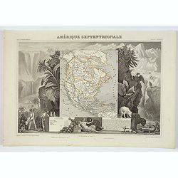
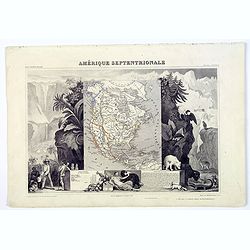
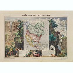
Amerique Septentrionale.
A beautiful map of the United States with Texas as a Republic, and extending into present day Canada, Russia is in control of Alaska, and Mexico's northern border defined...
Date: Paris, ca 1850
Selling price: ????
Please login to see price!
Sold in 2020
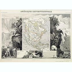
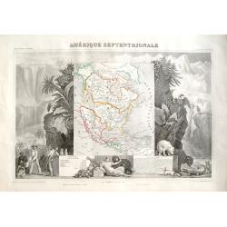
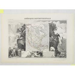
Amerique Septentrionale.
A beautiful map of the United States with Texas as a Republic, and extending into present day Canada, Greenland and the Arctic are shown, Russia is in control of Alaska, ...
Date: Paris, ca 1850
Selling price: ????
Please login to see price!
Sold in 2020
Wa-Em-Boesh-Kaa, A Chippeway Chief
A beautifully defined lithograph of a Chippewa chief, from Mckeeney and Hall?s Indian Tribes of North America, perhaps the most important work ever published on North Ame...
Date: Philadelphia, ca.1851
Selling price: ????
Please login to see price!
Sold
Amérique Septentrionale
Important French map of North America, showing Texas as an independent republic. The population table lists Texas with 200.000 and the United States with 19.000.000 inhab...
Date: Paris 1851
Selling price: ????
Please login to see price!
Sold in 2008
Carte de l'Amerique du Nord...
Excellent detailed map of North America, including early western Territorial borders : only OR, CA, NM, UT, TX and NE in the west as well as Russian America.Nice detail t...
Date: Paris, 1851
Selling price: ????
Please login to see price!
Sold in 2019
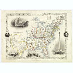
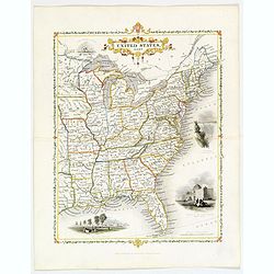
United States.
This is John Tallis’ pretty map of the United States, published mid nineteenth century. The map is surrounded by a number of delightful steel engraved vignettes and the...
Date: London, 1851
Selling price: ????
Please login to see price!
Sold in 2018
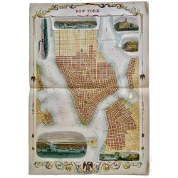
New York.
Rare, double page map of New York by John Tallis with 6 beautiful vignettes. Includes vignettes of City Hall, the Custom's House, the Narrow's from Fort Hamilton, a New ...
Date: London, 1851
Selling price: ????
Please login to see price!
Sold in 2019
Amérique Septentrionale.
Map of North America showing the Republic of Texas, the United States extends into present-day Canada, Russia is in control of Alaska, and Mexico's northern border is acc...
Date: Paris, A. Combette, 1852
Selling price: ????
Please login to see price!
Sold in 2009
Amérique Septentrionale.
A very decorative map with the Republic of Texas, the United States extending into present-day Canada, Russia in control of Alaska, and Mexico's northern border according...
Date: Paris, A.Combette, ca. 1852
Selling price: ????
Please login to see price!
Sold in 2013
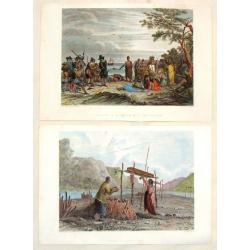
(2 Engravings) Interview of Massacoit with the Pilgrims and Feeding the Dead.
Two steel engravings featuring life among Native Americans in the early times. From "History of the Indian Tribes of the United States", published by Lippincott...
Date: Philadelphia, 1852
Selling price: ????
Please login to see price!
Sold in 2016
Amerique Septentrionale.
Beautiful map with the United States extending into present day Canada, Russia in control of Alaska and Mexico's northern border according to the Treaty of 1810. Surround...
Date: Paris, A. Combette, 1852
Selling price: ????
Please login to see price!
Sold in 2019
Carte de L'Amerique Septentrionale dresee et dessinee
An uncommon map of North America by J. G. Barbie du Bocage. It shows all of North America from the Arctic Circle to the northern most parts of South America. The US is sh...
Date: PARIS, 1852
Selling price: ????
Please login to see price!
Sold in 2020
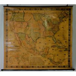
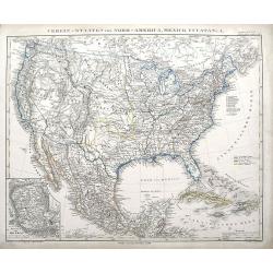
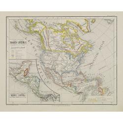
New Map of that Portion of North America Exhibiting..
Full title: New Map of that Portion of North America Exhibiting the United States and Territories, the Canada's, New Brunswick, Nova Scotia and Mexico, also Central Ameri...
Date: Baltimore 1853
Selling price: ????
Please login to see price!
Sold
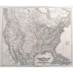
Vereinigte Staaten von Nord America und Mexico
Famous German steel-engraved map of the United States and Latin America, published in Stieler's Schul-Atlas. Includes much topographical detail and curiously shaped state...
Date: Gotha, c. 1853
Selling price: ????
Please login to see price!
Sold
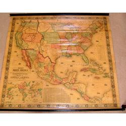
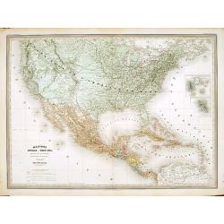
New Map of the Portion of North America, Exhibiting the United States and Territories, The Canadas, New Brunswick, Nova Scotia, and Mexico also Central America, and the West India Islands.
Possibly the most interesting and attractive 19th-century wall map of North America. Published in 1853 by Jacob Monk, this large and beautiful wall map details much of No...
Date: Baltimore, 1853
Selling price: ????
Please login to see price!
Sold in 2018
Etats-Unis. . .
Very detailed map of the United States of America, prepared by Auguste Henri Dufour (1798-1865). From La Terre Atlas Historique et Universel de Geographique. Published in...
Date: Paris, 1855
Selling price: ????
Please login to see price!
Sold in 2020
North America.
Important and uncommon later edition by Rapkin based on Tallis' maps. The vignettes have been removed and the map is issued in black and white. With decorative borders an...
Date: London 1855
Selling price: ????
Please login to see price!
Sold
North America.
Important and uncommon later edition of Tallis map. The vignettes have been removed and the map is issued in black and white. Very detailed with numerous place names and ...
Date: London, c.1855
Selling price: ????
Please login to see price!
Sold in 2011
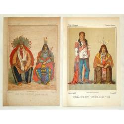
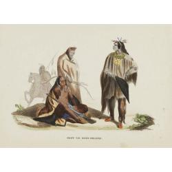
Cavaliere Yuto e Capo Arrapohe & Capo Sioux Yanctons e Capo Ponkas. (2 prints)
Two chromolithograph prints of Native Americans including those from the Arrapoho and Ponka tribes. They are from an unidentified source by an anonymus artist. The publis...
Date: Rome, c.1855
Selling price: ????
Please login to see price!
Sold in 2016
North America.
Very detailed and up-to-date map of North America, from Russian America (Alaska) to Panama, including the West Indies. With numerous place names and Indian tribes! This ...
Date: London, ca. 1855
Selling price: ????
Please login to see price!
Sold in 2013
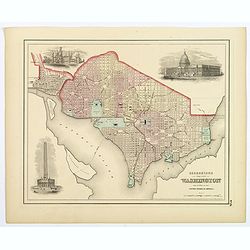
Georgetown and the City of Washington, the Capital of the United States of America.
An excellent 1855 example of Colton's plan of Washington D.C. and Georgetown. It covers the city in detail from Georgetown (Georgetown University, then College, shown) in...
Date: New York, 1855
Selling price: ????
Please login to see price!
Sold in 2018
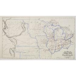
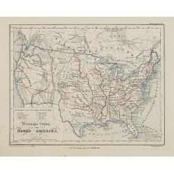
A New Map of the Great West Published by Miller, Orton & Mulligan, New York and Auburn. E. F. Beadle, Buffalo.
This map extends from Ohio to the Rocky Mountains, north of the Ohio River and Indian Territory, taken from "The States and Territories of the Great West", by J...
Date: Buffalo, 1856
Selling price: ????
Please login to see price!
Sold
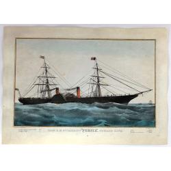
Iron R.M. Steamship “Persia”_ Cunard Line - Currier
Fine colored lithograph or chromolithograph featuring the steamship Persia of the Cunard Line. It was produced in about 1838 by Currier & Ives and is signed in print ...
Date: New York, 1856
Selling price: ????
Please login to see price!
Sold in 2017
United States of America the British Provinces, Mexico...
Large engraved folding map surrounded by a decorative grapevine border interspersed with twelve insets and a large American eagle in front of a port. The map's coverage ...
Date: New York, 1856
Selling price: ????
Please login to see price!
Sold in 2019
Carta dell' America settentrionale.
Uncommon Italian map with the Republic of Texas, the United States extending into present-day Canada, Russia in control of Alaska. Map is in outlined color.Many Indian na...
Date: Turin 1857
Selling price: ????
Please login to see price!
Sold
L'Amérique du Nord.
Large map of North America with an inset of the Aleutians in the lower left corner.
Date: Paris, 1858
Selling price: ????
Please login to see price!
Sold in 2022
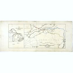
Map of lakes Huron, superior & Michigan, on a smaller scale. / Map of the Buffalo, Brantford & Goderich railway west Canada with its connections
Two maps on one sheets. First map of "Map of lakes Huron, superior & Michigan, on a smaller scale." measuring 227 x 150mm. The map to the right "Map of...
Date: London, after 1858
Selling price: ????
Please login to see price!
Sold in 2020
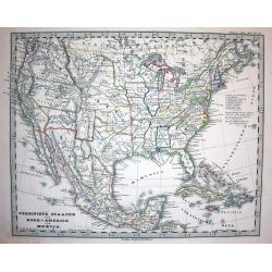
Die Vereinigten Staaten von Nord America nebst Canada.
A fascinating map of the United States, also parts of Canada and Mexico. Names several Territories and also Indian Territory. One of the most detailed maps of its time.
Date: Weimar, 1858
Selling price: ????
Please login to see price!
Sold in 2017
Nord America mit Westindien.
A great map with a lot of interesting details: Nebraska extends to Canada and the Rocky Mountains. Kansas includes most of today's Colorado. Large Utah and New Mexico Ter...
Date: Weimar, 1859
Selling price: ????
Please login to see price!
Sold in 2017
Verein-Staaten von Nord-America, Mexico, Yucatan u. A.
An early edition of this interesting map. Very detailed and with very interesting geography, such as a large New Mexico but no Arizona. Also a large Utah territory, and a...
Date: Gotha, 1859
Selling price: ????
Please login to see price!
Sold in 2018
Mexique Antilles, États-Unis..
Very detailed map of the United states. Engraved by Ch.Dyonnet, prepared by A.H.Dufour for his "Atlas Universele".
Date: Paris 1860
Selling price: ????
Please login to see price!
Sold
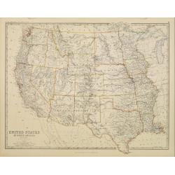
United States of North America. Western States.
Detailed map of western part of North America by Keith Johnston, a well-known publisher of maps who continually updated their regional maps. From his Royal Atlas . With g...
Date: Edinburg 1860
Selling price: ????
Please login to see price!
Sold
Amerique Septentrionale
Lovely map with an INDEPENDENT TEXAS. The United States extending into present day Canada, Russia in control of Alaska and Mexico's northern border according to the Treat...
Date: Paris 1860
Selling price: ????
Please login to see price!
Sold
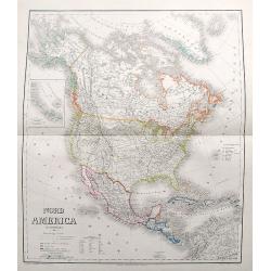
Noord-Amerika.
Uncommon map of North America including Canada and Mexico. Inset map of Central America. Lithography by J.H. van Weijer, published in Atlas der geheele Aarde [?] in 24 ka...
Date: Groningen, ca. 1860
Selling price: ????
Please login to see price!
Sold in 2008
Vereenigde Staten van Noord-Amerika.
Uncommon map of the United States of America. Lithography by J.H. van Weijer, published in Atlas der geheele Aarde [?] in 24 kaarten.
Date: Groningen, ca. 1860
Selling price: ????
Please login to see price!
Sold in 2015
Noord Amerika naar de bestebronnen vervaardigd onder toezigt van J. van Wijk Roelandsz. . .
A mid-nineteenth century map of America by the Dutch mapmakers and publishers Roelandsz and Zoon. Showing Alaska still belong to Russia.Engraved by J. Jaeger.
Date: Groningen, c. 1860
Selling price: ????
Please login to see price!
Sold in 2012
United States.
An unusual map of the United States. With excellent detail throughout. With "Indian Territory" north of Texas. Canada is named British America. Shows the Missou...
Date: ca. 1860
Selling price: ????
Please login to see price!
Sold in 2020

