Subscribe to be notified if similar examples become available.
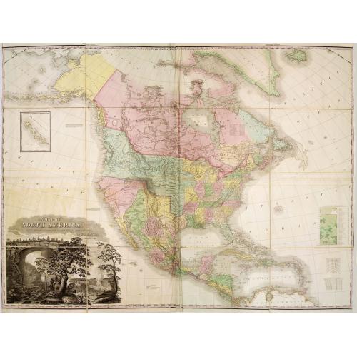
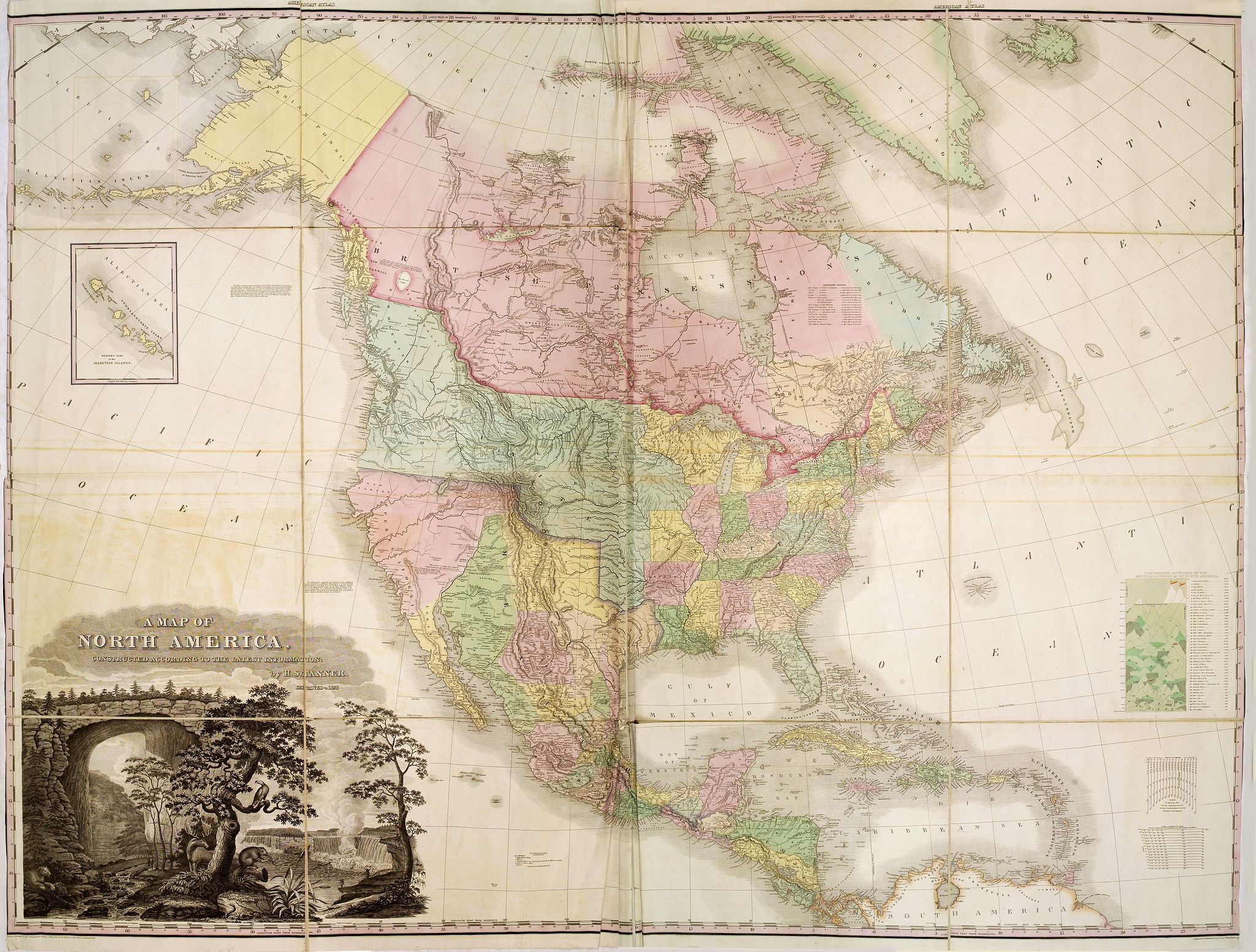
A Map of North America, Constructed According To The Latest Information ... Improved to 1828. |
||||||||||||||||||||
|
||||||||||||||||||||
|
|
||||||||||||||||||||
|
Selling price: $ Please login to see price!
Sold in 2013 Missed this item! Add your name to our mailing list and be the first to get notified about our newly added listings. . |
Collection - Save and collect this or any of your favorite items in one place.
If you want to save the items permanently, please sign in or create account first. |
|||||||||||||||||||
Description
It says in the title : "improved to 1828". This milestone map was first issued issued separately in 1822 and also bound in four sheets into Tanner's "New American Atlas" of 1823 and onwards. In lower left corner Entered according to Act of Congress, the 27th day of May 1822, by H. S. Tanner of the State of Pennsylvania. An "Improved edition" exists dated 1825, and this -the latest and rarest edition- improved and dated 1828. According to Rumsey: "Tanner updated the maps frequently over the next decade, and issued several editions or compilations of the atlas with the title pages dated 1823 or 1825, but with some of the maps dated as late as 1833. The collation of our five issues shows that no two copies are alike and that the maps were being constantly updated; however the choice of maps for each edition reveals a somewhat haphazard approach with some of the earliest states of a particular map appearing the one of the later atlas editions. A completely revised edition was issued in 1839, with the title page and most of the maps dated 1839." Rumsey mentions a 1633 edition of the American Atlas containing the Improved 1825 edition of the map. The Rumsey collections contains an example of the Improved 1828, however this was a separately issued case map.
The 1825 improved version has many changes in the north shore of Hudson's Bay and the western coast of Alaska, with "Kotzebue's Sound" added and including the 1825 dated boundary between Russian and British America.
This 1828 improved version has the area around Texas and Santa Fe redrawn as to political boundaries. Arkansas has been reduced to its second form (Paullin) and New and Old California are renamed Upper and Lower California.
Wheat describes the 1823 issue, calling it "a landmark - a great cartographical achievement - and its appearance brought to the fore the engraver who worked with Samuel Lewis back in 1804 on the little map of Louisiana... Tanner states in the Geographical Memoir accompanying his maps that he had devoted nearly ten years study to this subject, using a `globular projection,' similar to that used by Arrowsmith. He used as a basis Kotzebue, Arrowsmith and Vancouver, and for the British Possessions Mackenzie, Harmon's Journal, and Hearne's map of the Coppermine River. For the United States he used the map of Lewis and Clark, and by correcting the longitude given by these explorers by that of Lieutenant Graham for Council Bluffs, he was enabled to construct a whole new longitudinal scale for which he placed the `Oregon Mountains' three degrees farther East. He also used Thomas Nuttall's work for parts east of the 100th meridian..."
The map shows the two mythical rivers flowing from the area just west of the Rocky Mountains to the Pacific, draining the mythical lakes of Timpanagos and Teguayo. With two insets : "Western Part of the Alleutian Islands" and "Comparative Altitudes Of The Mountains, Towns &c. Of North America".
This map of North America was the progenitor of a long line of famous maps" (Wheat, II: pp. 82-87).
The magnificent title cartouche combines various symbols of America, including the Niagara Waterfalls, depictions of a rattlesnake, an eagle, a beaver, a moose, a polar bear, illustrations of Native Americans, and a rendering of Natural Bridge. The picture of Niagara is a combination of Vanderlyn's "A View of the Westerly Branch," used for the Horseshoe Falls portion of the image, and the left part of his "A Distant View of the Falls of Niagara," used for the American Falls portion of the image.
Henry Schenck Tanner (1786-1858) was born in New York City but removed early to Philadelphia. Trained as an engraver, he engraved many of his maps in the 1804 edition of A New and Elegant General Atlas of Arrowsmith and Lewis. He engraved the frontispiece and many of the maps in John Melish's Military and Topographical Atlas of the United States (1813 and 1815). and with J.Vallance, engraved Melish's fundamental "Map of the United States" (1816), the text accompanying which shaped Tanner's thought. In 1818-1823 he published A New American Atlas, in parts, which went to many editions. In 1825 his Map of Mexico appeared, and in 1829 his map of the United States. He also published many atlases.
Reference: Phillips Maps page 599; Wheat, Mapping the Transmississippi West, 350.
FAQ - Guarantee - Shipping
Buying in the BuyNow Gallery
This item is available for immediate purchase when a "Add to Cart" or "Inquire Now" button is shown.
Items are sold in the EU margin scheme
Payments are accepted in Euros or US Dollars.
Authenticity Guarantee
 We provide professional descriptions, condition report (based on 45 years experience in the map business)
Paulus Swaen warrants the authenticity of our items and a certificate of authenticity is provided for each acquired lot.
Condition and Coloring
We indicate the condition of each item and use our unnique HiBCoR grading system in which four key items determine a map's value: Historical Importance, Beauty, Condition/Coloring and Rarity.
Color Key
We offer many maps in their original black and white condition. We do not systematically color-up maps to make them more sellable to the general public or buyer.
Copper engraved or wood block maps are always hand colored. Maps were initially colored for aesthetic reasons and to improve readability. Nowadays, it is becoming a challenge to find maps in their original colors and are therefor more valuable.
We use the following color keys in our catalog:
Original colors; mean that the colors have been applied around the time the map was issued.
Original o/l colors; means the map has only the borders colored at the time of publication.
Colored; If the colors are applied recently or at the end of the 20th century.
Read more about coloring of maps [+]
Shipping fee
A flat shipping fee of $ 30 is added to each shipment by DHL within Europe and North America. This covers : International Priority shipping, Packing and Insurance (up to the invoice amount).
Shipments to Asia are $ 40 and rest of the world $50
We charge only one shipping fee when you have been successful on multiple items or when you want to combine gallery and auction purchases.
Read more about invoicing and shipping
FAQ
Please have a look for more information about buying in the BuyNow gallery
Many answers are likely to find in the general help section.
Collection
![]()
With Collection you can collect all your favorite items in one place. It is free, and anyone can create his or her Virtual map collection.
Unless you are logged in, the item is only saved for this session. You have to be registed and logged-in if you want to save this item permanently to your Virtual Collection.
Read More[+]
Register here, it is free and you do not need a credit card.
Add this item to
Virtual Collection
or click the following link to see my Collection.
| Digital Image Download | |
|
Paulus Swaen maintains an archive of most of our high-resolution rare maps, prints, posters and medieval manuscript scans. We make them freely available for download and study. Read more about free image download |
Click the image for a free small image download. |
In accordance with the EU Consumer Rights Directive and habitually reside in the European Union you have the right to cancel the contract for the purchase of a lot, without giving any reason.
The cancellation period will expire 14 calendar days from the day after the date on which you or a third party (other than the carrier and indicated by you) acquires, physical possession of the lot. To exercise the right to cancel you must inform Paulus Swaen Inc, of your decision to cancel this contract by a clear statement (e.g. a letter sent by post, or e-mail (amsterdam@swaen.com).
To meet the cancellation deadline, it is sufficient for you to send your communication concerning your exercise of the right to cancel before the cancellation period has expired.
