Browse Listings in America > North America > North Pole
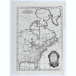
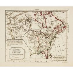
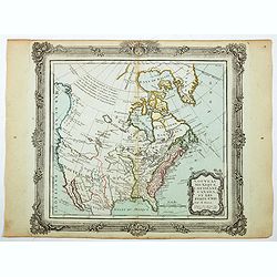
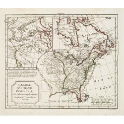
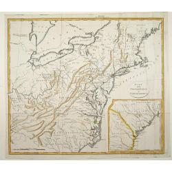
Canada IIe. Feuille.
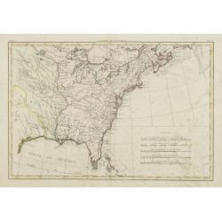
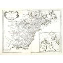
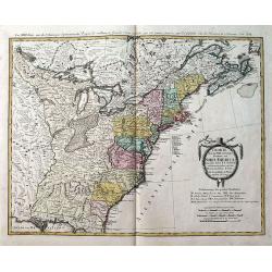
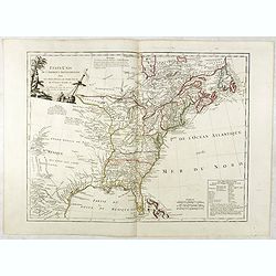
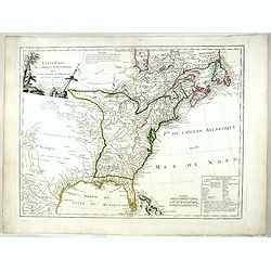
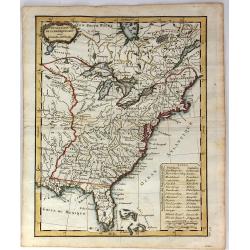
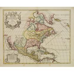
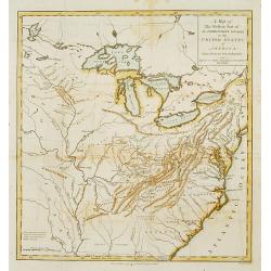
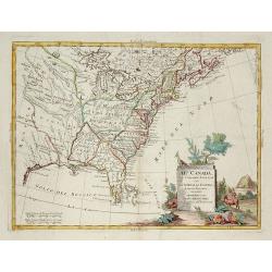
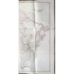
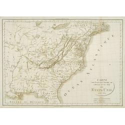
Attractive map covering the eastern half of the United States, from the gulf of Mexico as far as Canada. Boundaries outlined in hand color.From theAtlas moderne ou collec...
Date: Paris, ca 1783
Selling price: ????
Please login to see price!
Sold in 2013
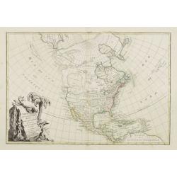
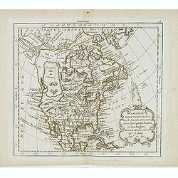
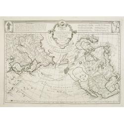
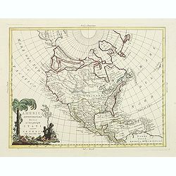
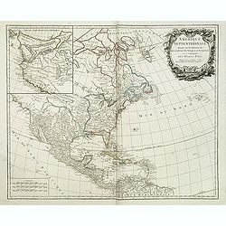
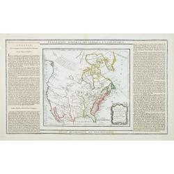
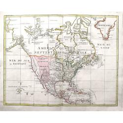
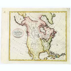
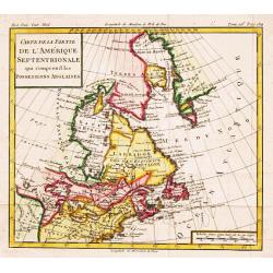
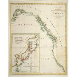
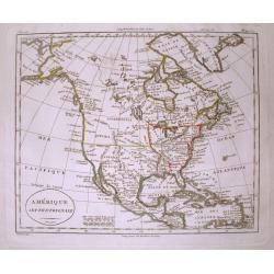
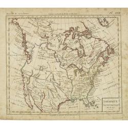
L' Amerique Septentrionale divisée en ses principaux Etats... (Sea of the West)
Attractive map of North and Central America, ornated with a decorative title cartouche. Boundaries outlined in hand color.Showing the explorations of Verenrye with regard...
Date: Paris, 1771-1783
Selling price: ????
Please login to see price!
Sold in 2017
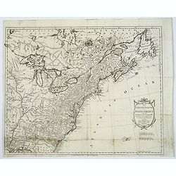
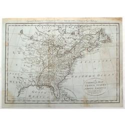
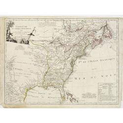
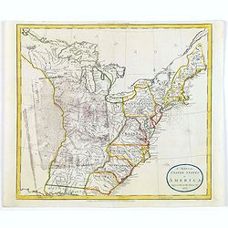
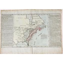
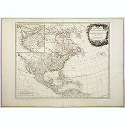
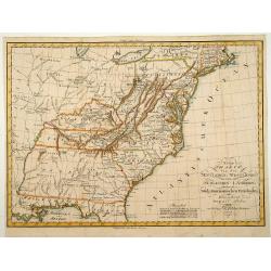
![[No title] East coast of US.](/uploads/cache/23469-250x250.jpg)
[No title] East coast of US.
Covering the French Louisiana and the British Colonies with their western boundary on the Mississippi River.Nice detail, particularly of the French forts and Indian villa...
Date: Paris ca 1783
Selling price: ????
Please login to see price!
Sold in 2014
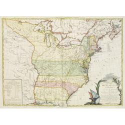
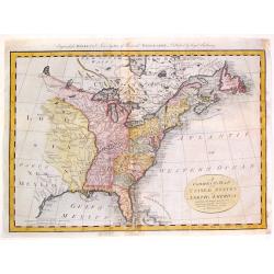
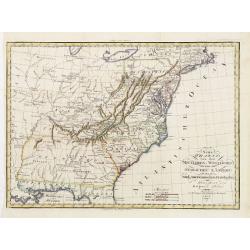
CARTE DES ETATS-UNIS D'AMERIQUE, et du Cours du Mississipi. . .
Separate publication. First state of three. First published in 1783 by Desnos, then by Esnauts et Rapilly and was re-issued in 1787. Louis Brion de la Tour was a military...
Date: Paris, 1783
Selling price: ????
Please login to see price!
Sold in 2013
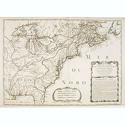
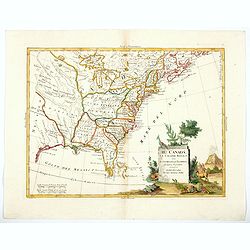
Carte Du Canada et de La Louisiane Qui Forment La Nouvelle France et Des Colonies Anglois . . . 1756
An important and rare pre-revolutionary French Indian war map by Nolin of Canada and the British Colonies, south to the Florida Peninsula, and from the eastern coastline ...
Date: Paris, 1783
Selling price: ????
Please login to see price!
Sold
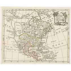
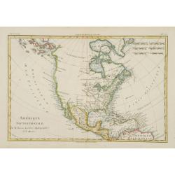
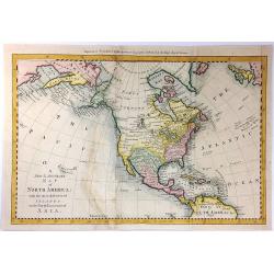
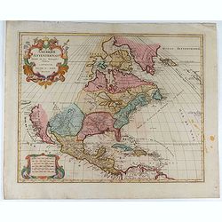
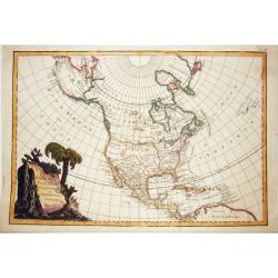
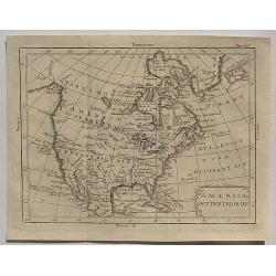
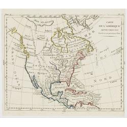
Amérique septentrionale avec les nouvelles découvertes. . .
Large Mer de L'Quest. Rare map of North America, showing a remarkable NW Coast of America, including the recently discovered sea (by the Russians) of the West. The NW Coa...
Date: Paris, 1783
Selling price: ????
Please login to see price!
Sold in 2019
Map of the United States in North America: with the British, French and Spanish Dominions adjoining, according to the Treaty of 1783.
One of the earliest obtainable English Maps to name the newly independent United States of America.The map shows the United States extending to the Mississippi River, wit...
Date: London, 1783
Selling price: ????
Please login to see price!
Sold in 2017
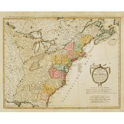
![AMERIQUE Septentrionale avec ses principales Divisions et leurs Capitales. [Mer de l'Ouest].](/uploads/cache/83552-250x250.jpg)
AMERIQUE Septentrionale avec ses principales Divisions et leurs Capitales. [Mer de l'Ouest].
An outlined colored map of north America , showing the Baye d'Hudson and the mythical 'Mer de l'Ouest'. With the names of cities, provinces and much more. With a numbered...
Date: Paris, 1783
Selling price: ????
Please login to see price!
Sold in 2020
Parte del Nord del America Settentrionale ad uso della storia filosofica e politica degli Stabilimenti e del Commercio degli Europei nelle due Indie.
Uncommon map of the eastern part of North America. Drawn by R. Bonne for an Italian version of Abbé Raynal's Histoire philosophique et politique".
Date: 1783
Selling price: ????
Please login to see price!
Sold in 2020
Charte uber die XIII vereingte Staaten von Nord-America..
Fine large map of the newly formed United States of America. The southern states are shown with their western boundaries on the Mississippi River, although the coloring s...
Date: Nuremberg ca. 1784
Selling price: ????
Please login to see price!
Sold
Carte des nouvelles decouvertes au Nord de la Mer du Sud.
Although concentrating on the northern Pacific, this map show all of North America and Mexico.A very interesting Northwest Passage is shown.While the Russian coastline is...
Date: Venice, 1776 - 1784
Selling price: ????
Please login to see price!
Sold in 2008
Carte Générale du Canada, de la Louisiane, de la Floride, de la Caroline..
Map of the eastern part of the United States and Canada. With inset map of Hudson and Baffin bays. in the lower right corner.Venetian edition of d'Anville's map, from &qu...
Date: Venice, 1776 - 1784
Selling price: ????
Please login to see price!
Sold in 2013
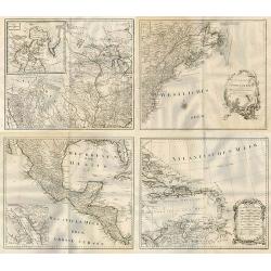
![Bowles's new pocket map of the following Independent States of North America : viz. Virginia, Maryland, Delaware, Pensylvania, New Jersey, NewYork, Connecticut & Rhode Island [. . .] by Lewis Evans.](/uploads/cache/34894-250x250.jpg)
Bowles's new pocket map of the following Independent States of North America : viz. Virginia, Maryland, Delaware, Pensylvania, New Jersey, NewYork, Connecticut & Rhode Island [. . .] by Lewis Evans.
Rare map, based on Evans' General Map of the Middle British Colonies In America (publ. as of 1755). The first map to eliminate "Middle British Colonies" and rep...
Date: London, 1784
Selling price: ????
Please login to see price!
Sold
A Correct Map of the United States of North America Including the British and Spanish Territories, Carefully Laid Down Agreeable to the Treaty of 1784
Fine early map of the United States with the Mississippi River as the Western Boundary. Created at the end of the American Resolution, after the Treaty of Paris. Publishe...
Date: London, 1784
Selling price: ????
Please login to see price!
Sold in 2017
A Correct Map of the United States of North America Including the British and Spanish territories, Carefully Laid Down Agreeable to the Treaty of 1784
One of the first maps published after the American Revolution, after the TREATY of PARIS. The west of the U.S. was Louisiana and New Mexico and west of the Mississippi ma...
Date: London, 1784
Selling price: ????
Please login to see price!
Sold in 2015
Charte über die XIII. vereinigte Staaten von Nord-America, Entworfen duch F.L. Güssefeld. . .
A large map of the 13 United States, shortly after the American Revolutionary War or the American War of Independence, which ended in 1783. A very detailed map with many ...
Date: Nuremberg, 1784
Selling price: ????
Please login to see price!
Sold in 2019
ETATS-UNIS / DE L'AMÉRIQUE SEPTENTRIONALE / Avec / LES ISLES ROYALE, DE TERRE NEUVE, / DE S.T JEAN, L'ACADIE, &c. / 1785. / Supplement a l'Atlas de M. Robert de Vaugondy. / a Paris Ches Boudet Ingenieur du Roi.
Rare early map of the newly created United States with the variant imprint of Boudet. The map is highly detailed, extending to the Rio Grande and including notes on the S...
Date: Paris 1785
Selling price: ????
Please login to see price!
Sold
America settentrionale divisa ne'suoi principali stati.
Decorative and detailed map of North America, with some Contemp. manuscript notations in the Pacific.The map includes a notation of a Chinese Colony Fou Sang, based upon ...
Date: Venise, 1785
Selling price: ????
Please login to see price!
Sold in 2012
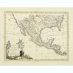
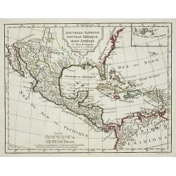
Messico ouvero Nuova Spagna che contiene Il Nuova Messico La California con una Parte de Paesi Adjacenti. . .
Decorative and detailed map of the southern part of the United States, Mexico and Central America. The map is filled with remarkable detail throughout, particularly in Te...
Date: Venise, 1785
Selling price: ????
Please login to see price!
Sold in 2019
America settentrionale divisa ne\'suoi principali stati.
Decorative and detailed map of North America, with some Contemp. manuscript notations in the Pacific.The map includes a notation of a Chinese Colony Fou Sang, based upon ...
Date: Venise, 1785
Selling price: ????
Please login to see price!
Sold in 2011
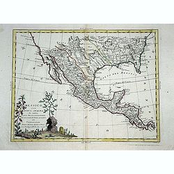
Messico ouvero Nuova Spagna che contiene Il Nuova Messico La California con una Parte de Paesi Adjacenti. . .
Decorative and detailed map of the southern part of the United States, Mexico and Central America. The map is filled with remarkable detail throughout, particularly in Te...
Date: Venise, 1785
Selling price: ????
Please login to see price!
Sold in 2011
Messico ouvero Nuova Spagna che contiene Il Nuova Messico La California con una Parte de Paesi Adjacenti. . .
Decorative and detailed map of the southern part of the United States, Mexico and Central America. The map is filled with remarkable detail throughout, particularly in Te...
Date: Venise, 1785
Selling price: ????
Please login to see price!
Sold in 2014
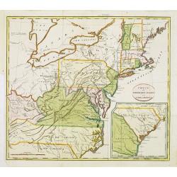
ETATS-UNIS DE L'AMÉRIQUE SEPTENTRIONALE Avec LES ISLES ROYALE, DE TERRE NEUVE...
Scarce early map of the newly created United States, with a note which includes 10 new proposed states proposed by Thomas Jefferson--Silvania, Michigania, Chersonesus, Ar...
Date: Paris, 1785
Selling price: ????
Please login to see price!
Sold in 2016
ETATS-UNIS DE L'AMÉRIQUE SEPTENTRIONALE Avec LES ISLES ROYALE, DE TERRE NEUVE...
Scarce early map of the newly created United States, with a note which includes 10 new proposed states proposed by Thomas Jefferson--Silvania, Michigania, Chersonesus, Ar...
Date: Paris, 1785
Selling price: ????
Please login to see price!
Sold in 2020
A Map of the United States of America Agreeable to the Peace of 1783.
An unusual map of the United States issued shortly after the end of the American Revolutionary War. The map depicts the United States according to the 1783 Treaty of Pari...
Date: London, 1785
Selling price: ????
Please login to see price!
Sold in 2018
A new map of North America, with the West India Islands..
An important and grand map of the United States, printed on four joined sheets and at a very large-scale, extends to include all of known North America and the West Indie...
Date: London, 1763-1786
Selling price: ????
Please login to see price!
Sold
L'Amerique septentrionale divisee en ses principaux etats.
A scarce map of North America showing the principal American States and the possessions of Spain and France. Not in Mcguirk, Mer de l'OuestOf cartographic interest is the...
Date: Paris, 1786
Selling price: ????
Please login to see price!
Sold in 2021
AMERIQUE SEPTENTRIONALE dressée sur les Relations les plus modernes des Voyageurs et Navigateurs ou se remarquent LES ETATS UNIS. . .
This large map of North America and the West Indies was originally published in 1750: however after the Treaty of Paris recognized the United States in 1783 the map was '...
Date: Paris, after 1786
Selling price: ????
Please login to see price!
Sold in 2011
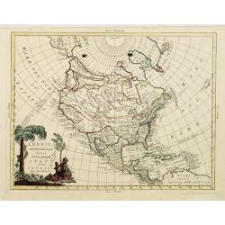
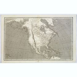
Amerique Septentrionale.
Fine map of Northern and Central America, showing even part of the South American continent, prepared by R.Bonne and included in his Atlas Encyclopédique.. Rigobert Bonn...
Date: Paris 1787
Selling price: ????
Please login to see price!
Sold
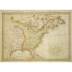
Carte Generale des Etats de Virginie, Maryland, Delaware, Pensilvanie, Nouveau-Jersey, New-York, Connecticut et Isle de Rhodes. Ainsi que des Lacs Erie, Ontario, et Champlain. D'Apres la Carte Ameriquaine de Louis Evans
Nice french map of the eastern part of the USA with the great lakes.
Date: Paris, 1787
Selling price: ????
Please login to see price!
Sold in 2013
A correct map of the United States of North America..
Fine and uncommon map of the United States according to the treaty of 1784. Engraved for BANKE'S New System of Geography, Published by the Kings Royal Licence.Thomas Bowe...
Date: London, 1787
Selling price: ????
Please login to see price!
Sold in 2011
Etats-Unis de l' Amerique Seple. avec le Canada et la Floride
An attractive, early map of eastern United States and Canada decorated with a Baroque style title cartouche.Interestingly, North and South Carolina, plus Georgia, extend ...
Date: Paris, 1787
Selling price: ????
Please login to see price!
Sold in 2016
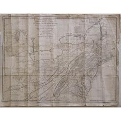
![[untitled map showing the route of the Continental Army from Boston to Yorktown]](/uploads/cache/40226-250x250.jpg)
[untitled map showing the route of the Continental Army from Boston to Yorktown]
Revolutionary War Battle map covering the East Coast of America from Boston Harbor to the Pamptico River in North Carolina. Its primary purpose is to depict the route of ...
Date: Paris, c. 1787
Selling price: ????
Please login to see price!
Sold in 2018
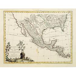
![L' Ancien et le nouveau Mexique, avec la Floride et la basse Louisiane.. [Texas,California]](/uploads/cache/84796-250x250.jpg)
L' Ancien et le nouveau Mexique, avec la Floride et la basse Louisiane.. [Texas,California]
Fine map on 2 joined sheets, of the southern United States [Florida, Louisiana, Texas, New Mexico and California , further on Mexico, the Central American States, and the...
Date: Paris 1787
Selling price: ????
Please login to see price!
Sold in 2021
DES POSSESSIONS FRANCOIS AUJOURD'HUI SOUS LA DOMINATION ANGLOIFES.
An interesting, decorative map from Labrador and the Hudson Bay area in Canada to the Gulf of Mexico. Inland as far as the Lake of the Woods and the Great Plains. French ...
Date: Paris, 1787
Selling price: ????
Please login to see price!
Sold in 2022
Generalkarte von Nord America samt den Westindischen Inseln . . .
Map of the North American coastal states from New Scotland to Pennsylvania. Sheet 20 of Schraembl's "Allgemeiner Grosser Atlas", this is one of the first maps i...
Date: Vienna, 1788
Selling price: ????
Please login to see price!
Sold in 2020
![[Map of North West America with Great Lakes region.]](/uploads/cache/26129-250x250.jpg)
[Map of North West America with Great Lakes region.]
Map of New Mexico, Louisiana, parts of Georgia, North Carolina and the Michigan lakes. Inset map of Baffin and Hudson Bay.Sheet 21 of Schraembl's "Allgemeiner Grosse...
Date: Vienna, 1788
Selling price: ????
Please login to see price!
Sold in 2017
General Karte von Nord America samt den Westindischen Inseln Verfasst von Herrn Pownall.
A monumental map of North America, depicted shortly after the American Revolution. Printed on four sheets, not joined. Insets: Baffin & Hudson Bay. Engraver: J. Steng...
Date: Wien, 1788
Selling price: ????
Please login to see price!
Sold in 2019
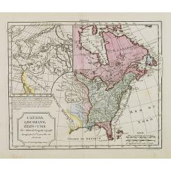
Canada, Louisiane, États-Unis.
Uncommon third state with changed title cartouche and corrigés par le Cen.Lamarche son successeur added to title.Two maps on one sheet. The map of the western part of No...
Date: Paris, 1790
Selling price: ????
Please login to see price!
Sold in 2010
Nouveau Mexique, Louisiane, Canada. . .
Map showing United States and Canada. Left and right a box with geographical information for each part country on the continent.Prepared by Louis Brion de la Tour and pub...
Date: Paris, 1790
Selling price: ????
Please login to see price!
Sold in 2016
A New & Accurate Map of North America: With the New Discovered Islands on the North East coast of Asia
This fine map focuses on the discoveries of Captain Cook in the Pacific Northwest and Alaska. Alaska is fairly well formed but misshapen, although much of the Aleutian Is...
Date: London, 1790
Selling price: ????
Please login to see price!
Sold in 2016
Amerique Septentrionale. . .
An interesting, and important map by the French cartographer, Robert de Vaugondy. A map of the United States beginning in the High Arctic and Baffin Bay, and then southwa...
Date: Paris, ca 1790
Selling price: ????
Please login to see price!
Sold in 2018
Amerique Septentrionale.
A large and scarce map of North America, including the recently discovered Sandwich Islands. With unusual areas, including a huge New Mexico and Louisian. Also a large pa...
Date: Augsburg, ca 1790
Selling price: ????
Please login to see price!
Sold in 2020
Nouveau Mexique, Louisiane, Canada..
A lovely 1786 map of North America by Desnos and Brion de la Tour. It shows North America according to the French with a northwest passage extending west from Labrador an...
Date: Paris, 1790
Selling price: ????
Please login to see price!
Sold in 2020
Amerique Septentrionale..
Richly embellished map of North America. Based on the Sanson map, which was the first to include all five Great Lakes. California now attached to the mainland. With a lar...
Date: Amsterdam 1792
Selling price: ????
Please login to see price!
Sold
North America.
Uncommon miniature map from Gibson's "Atlas Minimus, or a New Set of Pocket Maps of the several Empires, Kingdoms and States of the known World".
Date: London, 1792
Selling price: ????
Please login to see price!
Sold in 2011
A New and Accurate Map of North America from the best Authorities.
A scarce map of North America, from Brown's 'General Atlas', engraved by Menzies. It shows a 'River of the West', extending from the Juan De Fuca entrance to the R. Orega...
Date: Edinburgh, 1792
Selling price: ????
Please login to see price!
Sold in 2020
North America.
Uncommon miniature map from Gibson's "Atlas Minimus, or a New Set of Pocket Maps of the several Empires, Kingdoms and States of the known World". Together with ...
Date: London, 1792
Selling price: ????
Please login to see price!
Sold in 2017
Amerique Septentrionale . . .
Richly embellished map of North America. Based on the Sanson map, which was the first to include all five Great Lakes. California now attached to the mainland. With a lar...
Date: Amsterdam, 1792
Selling price: ????
Please login to see price!
Sold in 2020
Western Part of the Territories.
A Map of the western part of the territories belonging to the United States of America. Engraved for Imlay's Topographical Description of that Country . Engraved by T. Co...
Date: London 1793
Selling price: ????
Please login to see price!
Sold
RUSSIAN TEXT MAP - NORTH AMERICA.
A rare Russian, copper engraved map of north America. Based on the second state of the Janvier/Lattre map. It includes the results of Captain Cooks discoveries on America...
Date: St.Petersburg, 1793
Selling price: ????
Please login to see price!
Sold in 2021
Nouvelle Espagne, Nouvaeu Mexique, Isles Antiles.
Published by Charles Lamarche. Showing the most notable areas of New Spain in North, South and Central America from Nouveau Mexique to Terre Ferme as well as the Caribbea...
Date: Paris, 1794
Selling price: ????
Please login to see price!
Sold in 2011
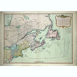
A new and correct map of the British Colonies in North America. . .
Famous map prepared by Gov. Pownall Major Holland. Northern British Colonies, Quebec, New Foundland, Nova Scotia, New England, New York. Including Hudson and James Bays, ...
Date: London, 1794
Selling price: ????
Please login to see price!
Sold in 2013
A new map of North America agreeable to the most approved maps and charts. . .
Detailed and uncommon map of North America with the Northwest labeled These Parts Are Entirely Unknown and Land discovered by de L'Isle 1741. Engraved by T.Condor and pub...
Date: London, 1794
Selling price: ????
Please login to see price!
Sold in 2013
Canada, Louisiane, États-Unis. Par Robert de Vaugondy Géographé, Corrigés par le C.en Lamarche son Successeur. L'An 3.em de la République Franc?.
Two maps on one sheet. The map of the western part of North America is most notable for it's depiction of "Mer de L'Ouest" or "Sea of the West".A grea...
Date: Paris, 1795
Selling price: ????
Please login to see price!
Sold in 2016
Carte de la Partie de l'Amerique Septentrionale, comprenant les Possessions Anglaises.
Louis Brion de la Tour (1756-1823), French geographer. ' Atlas Géneral, Civil et Ecclésiastique', 1766, ' Atlas Général', 1790-98. From Brunet's 'Histoire Universelle...
Date: Paris, c. 1795
Selling price: ????
Please login to see price!
Sold

Sauvage Iroquois.
Hand-colored mezzotints of Native Americans drawn by Labrousse and engraved by Laroque after Jacques Grasset de Saint-Sauveur.
Date: Paris,1796
Selling price: ????
Please login to see price!
Sold in 2011

Jongleur Iroquois.
Hand-colored mezzotints of Native Americans drawn by Labrousse and engraved by Laroque after Jacques Grasset de Saint-Sauveur.
Date: Paris,1796
Selling price: ????
Please login to see price!
Sold in 2011
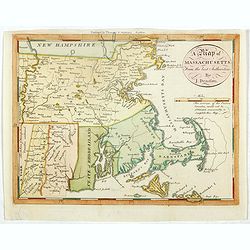
A map of Massachusetts from the best Authorities by J.Denison.
The map highlights Martha's Vineyard and Nantucket Island. The "Proposed Canal" is located near Sandwich. Beneath the oval title cartouche and distance scale is...
Date: Boston, 1796
Selling price: ????
Please login to see price!
Sold in 2021
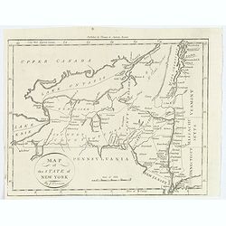
Map of the State of New York.
A nice post revolutionary war map of the state of New York by James Denison, published in Boston by Thomas and Andrews. Map shows rivers, mountains, roads, state boundari...
Date: Boston, 1796
Selling price: ????
Please login to see price!
Sold in 2019
Karte von .. Norstwestlichen Kuste America.
A very nice map centered on Northwest coast of America, including the city of Vancouver. On the lower left corner, an inset map (285x208 cm) of Japan, Taiwan and Chinese ...
Date: Berlin 1800
Selling price: ????
Please login to see price!
Sold
Part of the United States of North America.
Fine map of the eastern part of the United States, with in lower right an inset of South Carolina. An entirely new engraving, closely copied from the 1798 English edition...
Date: Berlin 1800
Selling price: ????
Please login to see price!
Sold
Il Canada le Colonie Inglesi con Luigiana e Florida . . .
Map of East coast of America including the Great Lakes. Fine title cartouche lower right hand corner. From Zatta's Atlante Novissimo.
Date: Venise, 1800
Selling price: ????
Please login to see price!
Sold in 2010
Theil der Vereinigten Staten von Nord America.
Detailed map of eastern part of the United States. In lower right hand corner inset map of Georgia, North and South Carolina.Showing routes of Mr. Weld.
Date: Germany, c.1800
Selling price: ????
Please login to see price!
Sold in 2012
Amerique Septentrionale.
Interesting map of North America, where the Mississippi River serves as the western boundary of the United States, with the western frontier under Spanish rule. Several s...
Date: Paris, c1800
Selling price: ????
Please login to see price!
Sold in 2014
North America.
John Arrowsmith's map of North America at the turn of the nineteenth century. It shows very little exploration west of the Mississippi River, and 'Louisiana' stretches fr...
Date: London, ca. 1800
Selling price: ????
Please login to see price!
Sold in 2017
America Settentrionale.
An interesting rare copper engraved map of North America by an unknown cartographer in about 1800. Text in Italian. The cartouche is quite plain but it does have minimal ...
Date: Spain, ca 1800
Selling price: ????
Please login to see price!
Sold in 2020
Il Canada le Colonie Inglesi con Luigiana e Florida. . .
A splendid map of the east coast of America including the Great Lakes. With a decorative and fine title cartouche lower right hand corner, and mileage scales. From Zatta'...
Date: Venice, 1800
Selling price: ????
Please login to see price!
Sold in 2020
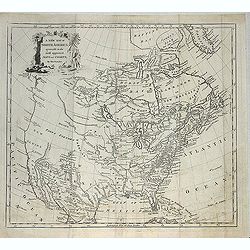
A Map Exhibiting all the New Discoveries in the Interior Parts of North America...
Published between 1795 and 1824, Aaron Arrowsmith's map of North America, is perhaps the single most important maps of North America after the American Revolution. It rep...
Date: London, 1802
Selling price: ????
Please login to see price!
Sold in 2020
Amérique Septentrionale an XI 1803.
Curious map of North America taken from "Boussole des speculateurs". According to the title, an uncommon encyclopedical work should be useful for investors and ...
Date: Paris, 1803
Selling price: ????
Please login to see price!
Sold in 2012
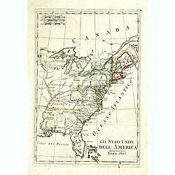
Gli Stati Uniti dell'America.
A rare map of the United States of America, from "Nuova geografia universale antica e moderna cosmografica, fisica, topografica, di commercio e d'industria politica,...
Date: Rome, Vincenzo Poggioli, 1803
Selling price: ????
Please login to see price!
Sold in 2020
ETATS UNIS DE L' AMERIQUE.
A scarce early, original outline colored map of the United States, showing 17 organised states. Georgia still extends to the Mississippi River, shortly before the organis...
Date: Paris, 1803
Selling price: ????
Please login to see price!
Sold in 2019
Carte des Etats du centre, de L'Quest et du Sud des Etats-Unis.
Detailed map of the East Coast of America. Engraved by S.Glot.
Date: Paris, ca. 1804
Selling price: ????
Please login to see price!
Sold
![[no title] Map of the United States and southern Canada.](/uploads/cache/44308-250x250.jpg)
[no title] Map of the United States and southern Canada.
This untitled map of the United States and southern Canada bears the imprimatur Smith & Jones Sculp. 13 Pleasant Row Pentonville (McCorkle #799.8). It is from an Engl...
Date: London, R.Philips, 1804
Selling price: ????
Please login to see price!
Sold in 2020
Neue Charte von dem Mittleren Westlichen .. Nord Amerika..
A very nice map centered on north America, including part of Florida, north and south Carolina, Pennsylvania, etc. Title cartouche on the lower right corner.
Date: Weimar 1805
Selling price: ????
Please login to see price!
Sold
Neue Charte von den Mittleren, Westlichen und Südlichen Ländern der Nord-Americanischen Freistaaten..
A detailed and rare map covering good part of the central and eastern American States.
Date: Weimar 1805
Selling price: ????
Please login to see price!
Sold
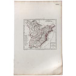
Carte de l'Amérique Septentrionale Divisée en ses principaux Etats.
Map of North and Central America. From Atlas de la Géographie de toutes les parties du monde .. Ouvrage destiné pour l'education, et nécessaire aux négocians, aux voy...
Date: Paris, Prudhomme, Levrault, Debray, 1806
Selling price: ????
Please login to see price!
Sold in 2023
Canada, Louisiane, États-Unis.
Although dated 1794/95 [l'An 3e.], the map is a copy of an earlier map which appeared in Robert de Vaugondy''s 1778 atlas. Two maps on one sheet. The map of the western p...
Date: Paris, 1794 - 1806
Selling price: ????
Please login to see price!
Sold in 2016

Homme & Femme Ottawas.
Hand-colored mezzotints of Native Americans engraved by Félix Mixelle and Lachaussée Jeune after Jacques Grasset de Saint-Sauveur.
Date: Paris,1801-1806
Selling price: ????
Please login to see price!
Sold in 2011

Homme & Femme Iroquoia.
Hand-colored mezzotints of Native Americans engraved by Félix Mixelle and Lachaussée Jeune after Jacques Grasset de Saint-Sauveur.
Date: Paris,1801-1806
Selling price: ????
Please login to see price!
Sold in 2011

