Browse Listings

Nova et recens emendata totius Regni Ungariae una cum adiacentibus et finitimis regionisbus delineatio.
Engraved map by Jan van Deutecum, here the very rare first edition published by Cornelis Nicola in Asterdam in 1596. In very attractive original coloring.A re-issued was ...
Place & Date: Amsterdam, Cornelius Nicol, 1596

Currus Veliferi Illmi. Pr. Mauritii Nassouvii. (Prince Maurits' sailing-carriage, designed by Simon Stevin. )
Prince Maurits' sailing carriages had been designed by Simon Stevin. The Prince, always accessible to new inventions of his old instructor, could not please the foreign a...
Place & Date: Amsterdam, 1649
![Hanc Tabulam continens Laetam Pharnambuci.. . [Brazil].](/uploads/cache/16521-250x250.jpg)
Hanc Tabulam continens Laetam Pharnambuci.. . [Brazil].
An extremely rare and decorative map of coast-line of Pernambuco. With one inset: In the upper left corner a map of Brazil, with title in five lines Dutch and five lines ...
Place & Date: Amsterdam, 1630
![Kantong [The Dutch Folly Fort off Canton]](/uploads/cache/05714-250x250.jpg)
Kantong [The Dutch Folly Fort off Canton]
Charming 18th water color on paper depicting The Dutch "Folly Fort" off Canton. Probably made by a western artist visiting China.Forts were built in several pla...
Place & Date: Canton?, c.1750

Pas-kaart vande Zee kusten van Venecuela met de Byleggende Eylanden. . .
Rare chart of the coast of Venezuela, including the islands of Curaçao, Bonaire, Aruba, etc.The chart has two insets, one (15x22cm) with a map of Curaçao, one smaller w...
Place & Date: Amsterdam, 1680

Schlanium vulgo Schlani Bohemiae oppidum.
Very decorative and rare panoramic town view of Schlan, Schlanium s. Slany.The engraver and publisher of prints, Mrs. Anna Beek of the Hague, enlarged this print, origina...
Place & Date: The Hague, 1700

Rare collection of costume plates.
Rare collection of costume plates published in Augsburg by the famous publishers Martin Engelbrecht, Ioh. Georg Hertel and the Jeremias Wolff Heirs.Composition :2 plates ...
Place & Date: Augsburg, ca. 1730

The Rubaiyat of Omar Khayyam (Edward Fitzgerald translation)
Edward FitzGerald, an outstanding writer who has done more than anyone to popularise English poetry. His best-known work, The Rubaiyat of Omar Khayyam (1859), began by be...
Place & Date: England, ca. 1930

Globe Terrestre Didié et Présénté a Monseigneur le Comté Maubec de Brancas...
Terrestial globe dated 1741. Complete title "Globe Terrestre Didié et Présénté a Monseigneur le Comté Maubec de Brancas Par Jacque Hardy. Dressé sur ...
Place & Date: Paris, dated 1741

Hydrograhica descriptio
This very rare chart is important as the first printed sea chart of the Mediterranean coast of Spain, Gibraltar, also depicting the northern coast of Marocco.Willem Bar...
Place & Date: Amsterdam, W.Blaeu, 1612

Nova Orbis Tabula in Lucem edita A.F.de Wit.
According to Shirley, De Wit's map is one of the most attractive of its time. The brilliant scenes in the corners combine images of the four seasons, the elements, and th...
Place & Date: Amsterdam, 1680

Chinae, olim Sinarum Regionis, nova descriptio. Auctore Ludovico Georgio.
The first map of China ever to appear in a Western atlas, west to the top. The first state without "las Philiooinas" somewhere in 1587 added to the plate. When ...
Place & Date: Antwerp, 1584

Desciption de lopulente et manifique ville de Venise.
Extremely rare panoramic view of Venice and neighboring islands (Murano, Burano, Torcello and Mazorbo), clearly depicting the city's architectural landmark. The surroundi...
Place & Date: Paris, 1646

Profil de la renomée ville et port d'Emstredam cappitalle des estats de Hollande.
Extremely rare panoramic town-view of Amsterdam seen from the river IJ.Exceptional bright, sharp example.The print is skillful copy of the print of Matthieu Merian, now w...
Place & Date: Paris, 1647

Terrae Yemen Maxima Pars, seu Imperii Imami, Principatus Kaukeban nec non ditionum Haschid u Bekil, Nehhm, Chaulan, Abu Arisch et Aden Tabula ...
South-west Arabia, with the Saudi Arabian city of Jizan south to Aden. With a fine title, cartouche. Based on a map by Carsten Niebuhr. With the name Sinus Arabicus Mare ...
Place & Date: Augsbourg, 1774
-250x250.jpg)
Vues du port de Llivourne. (set of 6 prints)
Sought-after complete suite of 6 engravings by S[tefano] Della Bella [1610-1664]. in a second state (of 2).Della Bella was born in Florence in 1610, and studied the art ...
Place & Date: 1654-1655

Poloniae, Lituaniaeq descriptio.
Fine general map of Poland. Rare; the second plate appearing in the post-1595 edition of the Theatrum. Only used until 1612.Based on the now-lost map of Waclaw Grodecki. ...
Place & Date: Antwerp, 1612

Plan du Port de St Augustin dans la Floride.
This chart shows a plan of the Port of St. Augustine in Florida.The only issue of this version of Bellin's map, slightly larger than the common version. Depths shown by s...
Place & Date: Paris, 1764

Quinta Asie Tabvla.
Woodblock map of Persia from Martin Waldseemüller's 1513 edition of Ptolemy, a landmark work that contributed to major advances in both Renaissance geography and map p...
Place & Date: Strasbourg, J. Schott, 1513

Nouvelle Mappa Monde.
State 2 of this fine double hemisphere world map, from an unusual perspective, with a "Mer de L'Ouest" or "Sea of the West". Paris is located at the c...
Place & Date: Venice, 1776 - 1784

Sincapour.
Early view of Singapore after Paris and engraved in aquatint technique by Sigismond Himely (1801-1872). Published as plate 28 in Voyage autour du monde par les mers de l'...
Place & Date: Paris, Finot, 1835
![[ Hong Kong / Canton ] Nieuwe Pas=Caart strekkende van Pta Cataon tot Pta. Lamtoan, langs de kusten van Cochinchina, Tonquin, Quangsi en Quantung [?] van Macao.](/uploads/cache/24951-250x250.jpg)
[ Hong Kong / Canton ] Nieuwe Pas=Caart strekkende van Pta Cataon tot Pta. Lamtoan, langs de kusten van Cochinchina, Tonquin, Quangsi en Quantung [?] van Macao.
A finely engraved and detailed chart of Vietnam reaching to Macao and present-day Hong Kong..Very rare: only included in the 6th volume (so-called secret atlas) of Van Ke...
Place & Date: Amsterdam, 1753

Chorographia Terrae Sanctae in Angustiorem. . .
Rare. Large visually rich map decorated with illustrations of the sacred objects and places of Judaism. In the bottom center is a plan of ancient Jerusalem, and the route...
Place & Date: Amsterdam, ca. 1700

Les jeunes voyageurs en Europe, ou description raisonnée des divers pays compris dans cette partie du monde.
The second edition of this fine travel companion is illustrated with 16 very decorative maps, each map surrounded by local products and specialties of the region. Include...
Place & Date: Paris, Thiériot, 1827

Carte des côtes du Golfe du Mexique compris entre la pointe sud de la presqu'Ile de la Floride et la pointe nord de la presqu'Ile d'Yucatan: Dresée d'après le observations et las plans des espagnols, ...
Detailed and important early chart of the Gulf Coast and Florida and dated 1800. First French edition of "the first printed [map] to show and name Galveston Bay&qu...
Place & Date: Paris, 1800

A chart of the China Sea inscribed to Monsr. D'APRES de MANNEVILLETTE .. To A.Dalrymple.
Most important milestone chart is based upon the surveys made from navigational surveys by Alexander Dalrymple (1737-1808]. He was the first hydrographer of the British A...
Place & Date: Paris, ca 1775

Turcici Imperii Imago.
The map shows the Ottoman Empire with Turkey, Black Sea, Mediterranean Sea, Arabia and North Eastern Africa. The map is decorated with a title cartouche and a portrait of...
Place & Date: Amsterdam, 1629

CANTON Kong-Teheou.
Very detailed (1:1.000.000) map centered on Macao and Victoria Island, showing soundings, English, Australian, Danish telegraph lines reaching Hong Kong and extended to M...
Place & Date: Paris, 1898 updated for june 1904

Carte particulière des environs de St Peters-bourg. . . / Plan de la ville faubourg et environs de St Petersbourg. . . / Carte pour l'intelligence de la guerre de Moscovie et de Suede. . .
A scarce and unusual plan of Saint Petersburg shown at a large scale and also, in a separate compartment, shown in its geographical context between the Gulf of Finland an...
Place & Date: Paris, c.1741

Secunda etas mundi. Folium XIII.
Schedel's world map was based on the cartographic system of Claudius Ptolemy, the great second-century AD geographer whose scholarship formed the foundation for map produ...
Place & Date: Nuremberg, 12 July 1493

Carte d'Europe . . .
Rare. Uncommon and decorative wall map of Europe, prepared by Clouet. With superb decoration including a wonderful rococo border with vignettes describing historical scen...
Place & Date: Paris, 1785-1788

Belchrijuinghe vande zee custen van Engelandt. . .
A rare Dutch text edition of this detailed early chart of the northern coast of England. West to the top. The mileage cartouche has no Latin captures. Decorated by a colo...
Place & Date: Leiden, Plantijn, 1585

Reis-kaart van het Britsche gezantschap van Hang-choe-foe naar Quang-choe-foe of Kanton in China.
Uncommon map of eastern part of China, showing a journey of the English Embassy from Hangzhou (south of Shanghai) to Guangzhou (Canton). The maps is giving a wealth of in...
Place & Date: Netherlands, c.1800

Botanibay, Englischer Verweisungs Ort fur Verbrecher. / Laijene Franzosicher Verweisungs Ort fur Verbrecher.
Copper engraving with four scenes and one portrait of Frederick III of Saxony on one sheet. In the upper part fanciful views of Botany Bay with English and French settlem...
Place & Date: Zittau, 1798-1800

Erfolgte Kapitulation zwischen dem General Bonaparte und den Gross Leister von Malta. Vor der Hauptstadt Walette zu Maltha, am 10 Juni 1798.
Copper engraving with three scenes and one portrait on one sheet. In upper a view of Bonaparte arriving at Valletta. Published in "Allgemeine Welt-Chronik oder neue ...
Place & Date: Zittau, 1798-1800
![Morokoshi Meisho Zue [Illustrated Description of Famous Sites of China].](/uploads/cache/34118-250x250.jpg)
Morokoshi Meisho Zue [Illustrated Description of Famous Sites of China].
Published in Osaka, Kawachiya Genhichiro, et al. [8 book sellers], slightly later issue but apparently in Edo period, using all the same woodblocks of original first edit...
Place & Date: Osaka, Edo, slightly later than Bunka 3, year of the tiger - 1806

De golf van Bengalen.
Rare chart of the Indian Ocean, with nice detail on Ceylon (Sri Lanka) with compass roses and a system of rhumb lines, soundings and anchorage's. Many place names. The pl...
Place & Date: Amsterdam, after 1669-1712

Isola di Madagascar o di S. Lorenzo Scoperta dà Portoghesi nell anno 1506. . .
Decorative and highly detailed map of Madagascar, including 2 decorative cartouches and other embellishments.The remarkable Vincenzo Coronelli (1650-1718), was a Francisc...
Place & Date: Venice, 1690

Pianta Geografia delle Isole di Malta, e Gozo della Sagra Religione Gerosolimitana di S. Giovanni delineata, ed incisa in quest anno 1761.
A rare map of Malta and Gozo printed by the priest Antonio Bova (1688 - 1775), who was active as engraver in Palermo ca. 1727-1773. He produced cartographic engravings, s...
Place & Date: Bova Ant., Palermo, 1761
![[Crimea]. Carte de la Cromée.](/uploads/cache/25719-250x250.jpg)
[Crimea]. Carte de la Cromée.
Mapmaker, Captain Jan Hendrik van Kinsbergen (1735-1819). Published by H. Friesman in 1787. This map first appeared in 1776 and was the first Russian map of the newly ann...
Place & Date: Amsterdam, H. Frieseman, 1787
![Vue de la Rivière d'Endeavour sur la Côte de la Nouvelle Hollande ou le Vaisseau fut mis à la bande. [Tome IV Pl. 1ère.]](/uploads/cache/26093-250x250.jpg)
Vue de la Rivière d'Endeavour sur la Côte de la Nouvelle Hollande ou le Vaisseau fut mis à la bande. [Tome IV Pl. 1ère.]
The first known landscape drawing of the east coast of Australia. A View of the Endeavour River, on the coast of New Holland, where the ship was laid on shore, in order t...
Place & Date: Paris, 1773

Canibales Insulae.
Rare, early Dutch nautical chart of the Caribbean from Puerto Rico southward.
Place & Date: Amsterdam, 1670

Carte historique de la France, et l'Angleterre depuis la naissance de Jésus-Christ jusqu'à l'an 1700, qui contient en abrégé les événements principaux de ces royaumes pendant l'empire romain. . .
A rare wall map showing a chronological tree of French and English historical events from the year of the birth of Christ until 1700. The map is prepared by Jérôme Andr...
Place & Date: Paris, c. 1721
![Anverpia, nobile in Barbantia oppidum, parrim maritimum . . . [Antwerp]](/uploads/cache/26518-250x250.jpg)
Anverpia, nobile in Barbantia oppidum, parrim maritimum . . . [Antwerp]
The bird's-eye plan provides an excellent view of the citadel, city, docks and fortifications. The city was defended by a line of fortification and a moat constructed und...
Place & Date: Cologne, 1585

Het Beloofde Landt Canaan door wandelt . . .
A beautifully engraved map of the ancient land of Canaan which roughly corresponds to present-day Israel. Cherubs hold up a draped cloth of key symbols, also a scale pane...
Place & Date: Amsterdam, 1682

Manuscript map of the Bay of Nagasaki.
An extremely rare manuscript chart in brown ink and wash color on a printed sheet of paper with a system of rhumblines and latitude scales. This chart shows the Bay of Na...
Place & Date: Amsterdam, 1750

Guyana, Surinam, Amapa.
Very rare Ottoman printed map of Guyana, Suriname and Amapa. With Trinidad, an inset map of the mouth of the Rivers Essequibo, Courantyne, Suriname with Paramaribo.From C...
Place & Date: Üsküdar (Istanbul), 1803

La Florida/ Peruviae Auriferae regionis Typus/ Guastecan.
The Chaves map of Florida is a prime example of an explorer's map since it records the recent discoveries of Cabeza de Vaca, De Soto, and Moscoso. The map revealed little...
Place & Date: Antwerp, 1592
![[ Manuscript map of the Ligurian coast from Pietra to Genova ].](/uploads/cache/26627-250x250.jpg)
[ Manuscript map of the Ligurian coast from Pietra to Genova ].
Very detailed French manuscript map of the Ligurian coast from Pietra and Finale, Savone to Genoa with the Maritime Alps in the background. The Liguria coast borders to n...
Place & Date: France, ca. 1790-1800

Plan de Constantinople, non compris ses faubourgs. Grave d'apres les documents du ministere de la Guerre par E. Olivier.
A very rare lithographic town-plan of Istanbul, Scale 98 yards to one inch., printed in Pera, Istanbul by E. Olivier. The ornate design on the top of the title is a tugh...
Place & Date: Péra, Istanbul, 1851

Nova Helvetiae Tabula.
A most decorative "carte à figures" map with panoramic views of Lucern, S.Gal, Bern, Solothurn, Schafhausen in upper border and Basel and Zurich in lower left ...
Place & Date: Amsterdam, 1630

Bern in der Schweitz.
Very fine panoramic of Bern. With a numbered key (1-25) of principal buildings in town.
Place & Date: Augsburg, 1740

Gustaaf Willem Baron van Imhoff.
Decorative portrait of Gustaaf Willem Baron van Imhoff, who was Governor for the V.O.C. (Dutch East Indian Company) in Indonesia.
Place & Date: Amsterdam, 1745

Hamburgum.
Engraved bird's-eye town-plan of Hamburg, two keys below. Frederick de Wit published after 1694 a town book of European and Asian cities (Theatrum Praecipuarum Totius Eur...
Place & Date: Amsterdam, ca. 1694

Carte de la Coste de La Rochelle a Brouaige et de l'Isle d'Oleron Observee par le S.r de Chattillon ingenieur du Roy.
Map of the island of Oléron, with an inset in lower left corner showing the route of an English fleet to La Rochelle. At the time of mapping the area was a stronghold of...
Place & Date: Paris, 1627

Paris.
A spectacular panoramic view of Paris, with legends numbered from 1-70 in French. With the title in a banderol.After a design by Friedrich Bernhard Werner (1690-1776) who...
Place & Date: Augsburg, ca. 1740

Imperii Russici et Tartariae Universae tabula novissima.
Decorative and rare map covering Russia, Tibet, China, Tartary, Korea, Taiwan and Japan prepared by J. M. Hasius. The sea between Japan and Korea is mentioned Mare Orient...
Place & Date: Utrecht, 1743
![.Tabula III Asiae. [Caucass and Armenia.]](/uploads/cache/27894-250x250.jpg)
.Tabula III Asiae. [Caucass and Armenia.]
Ptolemaic map of the region south of the Caucasus Mountains and between the Caspian Sea as far south as the headwaters of the Tigris River in the south and the Black Sea,...
Place & Date: Lyons, M. Servetus, 1535

The Traveller's Guide. A Map Of The Roads, Canals And Steam Boat Routes Of The United States ... Designed for the use of Travellers, By H.S. Tanner.
Rare first edition of Tanner's travel map in pocket map form, in it original red leather covers, with the map and no text, as issued. Ristow says the first edition was 18...
Place & Date: Philadelphia, 1825

De Haven en Straat von Gibraltar, Niewlyks getekend, en in`t licht gebracht door Johannes Covens en Cornelis Mortier tot Amsterdam.
Decorative map showing the siege of Gibraltar during the Spanish war of succession. This highly interesting map is richly ornated with three additional inset maps and vie...
Place & Date: Amsterdam, 1710
![.Taprobana Ins. Tabula XII Asiae. [Sri Lanka.]](/uploads/cache/27928-250x250.jpg)
.Taprobana Ins. Tabula XII Asiae. [Sri Lanka.]
Ptolemy's mythical island of Taprobana originally became associated with Sri Lanka although it was sometimes confused with Sumatra. Taprobana, as it was called on most ea...
Place & Date: Lyons, M. Servetus, 1535

La mer Mediterranee divisee en ses principales parties ou mers. . .
Very large map centered on the Mediterranean. With a sub title along upper margin "La Mer Mediterranée divisée en Mer de Levant et de Ponant Subdivisées en Leurs ...
Place & Date: Amsterdam, c.1705
![Amerique Septentrionale divisée en ses principales parties. . .1692. [California as an Island]](/uploads/cache/27961-250x250.jpg)
Amerique Septentrionale divisée en ses principales parties. . .1692. [California as an Island]
A very good impression of Jaillot's large map of North America, showing California as an Island, based upon Sanson's landmark map of 1656. A first state.The map shows the...
Place & Date: Amsterdam, c.1692

Europa, ad magnae Europae Gerardi Mercatoris. . .
General map of Europe, as well as Americae Pars, Greenland, Iceland, a Polar landmass, along with the mythical islands of Frisland, Drogeo, and Bradain. A large strapwor...
Place & Date: Amsterdam, 1628

Portugalliae que olim Lusitania..
The best-known map of Portugal, after Alvares Secco (1560), orientated west to the top of the sheet. Secco's map was copied by many mapmakers and publishers for upwards o...
Place & Date: Amsterdam, 1628

Pas-Kaat vaneen gedeelte van de Aethiopische Zee behelsende de Kusten Zanguebar, Ajan en Abex, en een gedeelte van de Arabische Kust. . .
A finely engraved and detailed chart of the most eastern tip of Africa, including Somalia, Djibouti, Yemen, Mauritius, and many other islands in the Indian Ocean.Very rar...
Place & Date: Amsterdam, 1753
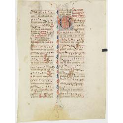
Leaf on vellum from an antiphonary.
A more than 600 years old antiphonary leaf, written in Besançon, in 1370. Musical notation on 4 bars, the staves are in red and the notes in black: numerous pen-flourish...
Place & Date: Besançon, 1370

Océanie.
A very decorative 19th century map of the Pacific Ocean, with hand colored lines indicating the extent of Polynesia, Mirconesia, Melanesia, and Malaysia (or Southeast Asi...
Place & Date: Paris, 1850

A newe mape of Tartary.
Early edition of one of the most decorative "carte à figures"- map of Tartary, known for its figured borders with costume figures, while above are vignettes of...
Place & Date: London, 1627

Nuova Pianta Iconografica.. Venezia.
Precise bird's-eye town-plan of Venice, clearly depicting the city's architectural landmark, being a reduction of Ughi's 8-sheet map of 1725. There is a grid engraved ove...
Place & Date: Venice, 1818

Cajanie, ou Bothnie Orientale Tirée de celles d'Andr Burae et de Isaac Massa. . .
Map of the Northern part of Gulf of Bothnia, today's border area between Sweden and Finland. The map derive from the work of the Swedish cartographer Andreas Bureus and I...
Place & Date: Paris, P.Mariette, 1666

EUROP, and the cheife Cities contayned therin described. . .
A good impression from an early edition of this famous and decorative "carte à figures"- map from the first world atlas produced by an Englishman - John Speed'...
Place & Date: London, 1627 - 1676

Jerusalem.
Engraved by Bastiaan Stoopendaal from Juan Bautista Villapando's imaginary town-plan of Jerusalem. This bird's-eye view is surrounded by 12 scenes, views and portraits of...
Place & Date: Amsterdam, 1682
![[ LANDSKROON ]. Oranda Fune no zu [= Depiction of a Dutch Ship].](/uploads/cache/28003-250x250.jpg)
[ LANDSKROON ]. Oranda Fune no zu [= Depiction of a Dutch Ship].
A very large and extremely detailed Japanese drawing on rice paper of a Dutch ship at the artificial island Deshima, the VOC's outpost in Nagasaki harbour. In the drawing...
Place & Date: Japan, Kansei 4, 2nd month, 9th day, 30 March? 1792
-250x250.jpg)
Hern Johann Baptisten Taveniers..Vierzig Jaehrige Reize..
This German edition includes Tavernier's map of Japan in a reduced form (210x315mm) and contains legends about the country's nature, e.g., where gold is mined and plottin...
Place & Date: Nuremberg, 1681

Vue de Boston vers le Cale du Port.
A view of the port of Boston, the center of New England shipping in the colonial period. The closing of the port after the Boston Tea Party led to the calling of the Firs...
Place & Date: Augsburg 1762

Nieuwe gemeten kaart van de colonie de Berbice met der zelver plantagiën en de namen der Bezitters. . .
Re-issue of his map from 1740, without the printed list of owners, with a large added contemp. hand-colored cartouche Relaas van de rebellie, ontstaan op de plantagien in...
Place & Date: Amsterdam, ca.1763

Angliae, Scotiae, et Hiberniae, sive Britannicar : Insularum descriptio.
A rare and ornate map with inset portraits of James First, Henry Prince of Wales Princess Anne of Denmark.Janssonius acquired the copperplate of van den Keere's 1604 Brit...
Place & Date: Amsterdam, 1621
![Summa philosophiae quadripartita, de rebus dialecticis, moralibus et metaphysicis . . [ With unrecorded world map ]](/uploads/cache/28639-250x250.jpg)
Summa philosophiae quadripartita, de rebus dialecticis, moralibus et metaphysicis . . [ With unrecorded world map ]
On page 107 a finely copper engraved world map (88x84mm.) Paradigma Terrae Plagas 4.ac 12. Ventorum situm indicans., centered on Europe and Africa, with parts of America,...
Place & Date: Leiden, Peter Rigaud, 1626

Carte d'Afrique Dressée pour l'instruction par Guillaume DeLisle. . .
The map is a rare re-issue of the Delisle map of 1722. In his first map of the continent in 1700, Delisle re-measured the Mediterranean, being the first to establish its ...
Place & Date: Paris, J.Dezauche, 1819