Recently Listed Listings

Novus de Leone Belgico eiusq topographia atq. Historica descriptione liber (…). Rerumque in Belgio maxime gestarum, inde ab anno Christi M.D.LIX. Usque ad annum M.D.LXXXVII perpetua narratione continatus.
ENLARGED EDITION, with 207 (of 208) engravings of a famous eyewitness account of the Dutch Revolt, with the famous "Leo Belgicus" map, here in its second state...
Date: Cologne, Gerardus Campensis for Frans Hogenberg, 1588

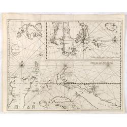
Le Nouveau miroir des voiages marins de la navigation de la mer occidentale & orientale.
A second and final French edition of this important sea atlas. Two engraved frontispieces, figure with volvelle, full-page figure, 48 double-page charts (one numbered 19....
Date: Antwerp, Chez Iean Bellere, a l’Aigle d’or, l’An M.CCCCCC (1600

Amstelodami celeberrimi hollandiae emporii delineatio nova.
Frederik de Wit’s beautiful bird's-eye view of the city. The Amstel river is still open water flowing through the city's heart. Only near the Dam, has it been covered b...
Date: Amsterdam, c.1700
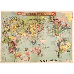
Japanese Stereotype Map of the World from 1932 Share Hitome de wakaru Manga sekai genjō chizu. At a glance: Cartoon Map of the Current World Situation. 目でわかる 漫画世界現状地圖
An extraordinary satirical map of the world was seen through Japanese eyes in the early 1930s as Japanese imperial ambitions strengthened. The map was published as an edi...
Date: Tokyo, Showa 7, or 1932
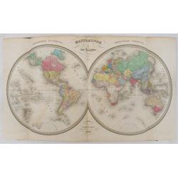
Atlas usuel de Géographie Moderne…
Complete with title page, contents page, and all 32 double-page maps of European and regional maps of the world, including Oceania, the Americas, Asia, Africa, etc. All i...
Date: Paris, c. 1865
Selling price: ????
Please login to see price!
Sold in 2024
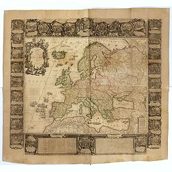
L'Europe Dressée Sur les Nouvelles observations. . .
A rare and monumental wall map of Europe, with original outline color, of four joined sheets, surrounded by text and vignettes printed on separate sheets.Created in 1740 ...
Date: Paris, 1700-1740
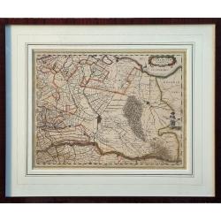
Ultraiectum Dominium.
A highly detailed map of Utrecht and its surroundings in the Netherlands.Additional shipping costs apply. The item is located in Schiedam (The Netherlands) and can be s...
Date: Amsterdam, ca 1635
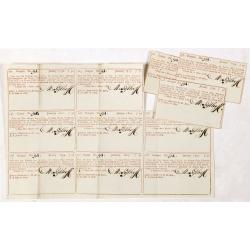
Coupon 94 voor een jaar interest voor f 1000 by hunne hoog vorstelyke doorluchtigheden de heere Frederik regeerende furst von Waldek. . .
9 Coupons for one year interest of 1000 florins being 50 florins payable on January 1796, 1797, 1798, 1799, 1800, 1801, 1802, 1803, 1804. For a loan made out by The Hague...
Date: The Hague / Amsterdam, 1786
Het Groote Tafereel der Dwaasheid.
AN EARLY ISSUE of this biting and vulgar satire on the Mississippi and South Sea Bubbles and an extraordinary visual record with 78 plates of the first banking crash, sho...
Date: Amsterdam, 1720
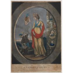
An Emblem of America / An Emblem of Africa / An Emblem of Asia / An Emblem of Europe.
An Emblem of America : This white female figure of Columbia, emblematic of the United States, represents America in a set of prints of the Four Continents. Standing besid...
Date: London, 1798

Kaart der Moluksche eilanden en vaarwateren … F.A.A. Gregory Luitenant ter zee …
Huge sailing chart centered on the Moluccas Islands. Published by Widow Gerard Hulst van Keulen.The publishing house van Keulen, were the most prominent chart makers at ...
Date: Amsterdam, 1847

Slusa, Teutonicae Flandriae opp. . . (Sluis)
Bird'eye view of the town of Sluis.From the greatest publication in this genre!. The Civitates was compiled and written by George Braun, Canon of Cologne Cathedral. Braun...
Date: Cologne, 1580

De custen van een deel van Denemarken en Swede. . .
A detailed chart of the coast Skane and Kalmar, with the island Öland. Decorated by a title and scale cartouche, a compass rose, several vessels and sea monsters, and de...
Date: Leiden, Plantijn, 1585
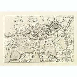
Pas-Caert vande ghelegetheyt vande Schans te Santvliet, Vertoonede de verdroncken overwaeterde Landen, nieuw aengewasse gorsingen,. . .
Showing the surrounding countryside of the cities of Antwerp, Santvliet, Lillo, Bergen op zoom, etc. The map is ponctuated by several fortifications to indicate the main ...
Date: Amsterdam, 1630

Kaerte van Bergen op Zoom, Steenbergen ende de nieuwe fortificatien gemaeckt tot bevrÿdinge van 't landt van ter Tolen in tjaar 1628.
Very detailed and scarce map showing Bergen Op Zoom, Steenbergen and its surrounding countryside. North to the left side.
Date: Amsterdam, after 1628

Siberia & Central Asia.
This map covers the eastern section of Russia as well as China, Japan, Korea, India and Tibet. The map is of interest for the use of Sea of Corea, the sea between Korea a...
Date: Boston, 1835

Kaartje van Asia. . .
Attractive and rare map of Asia. From Atlas Portatif . With a curious and oversized Hokkaido. The map is of interest for the use of Coreanse Zee for the sea between Korea...
Date: Deventer 1742
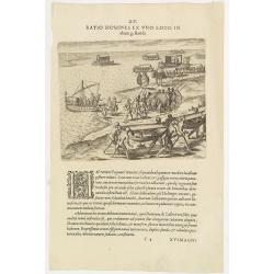
XV. Ratio Homines Ex Uno Loco In alium gestandi.
Scene in the kingdom of Pegu, now Myanmar, showing elephant, ships and locals.Theodore de Bry, a German engraver and book dealer, began a compilation of early voyages in ...
Date: Frankfurt, 1599

The Russian Empire in Europe and Asia . . .
Detailed map of the whole of Russia, extending from Poland to the Pacific and from Nova Zembla to Tartaria.The map is of interest for the use of Corea Gulf for the sea be...
Date: London, 1790
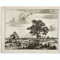
Saba, ville en Perse.
Decorative view of Sabā / Dakān Sorkh) which is a village in Vahdatiyeh Rural District in present-day Iran.In the foreground are camels and horses. This well-executed e...
Date: Leiden, 1719
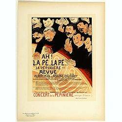
Ah la pé... La pé... La Pépinière Revue . . .
Chromo lithographed poster of Les Maîtres de l'Affiche being plate n°119. The "Les Maîtres de l'Affiche" contained 256 small for lithographic prints of the b...
Date: Paris, Imprimerie Chaix, 1898
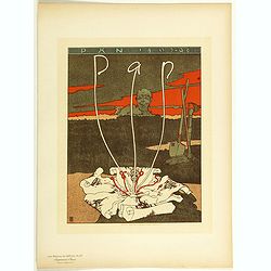
Pan.
Chromo lithographed poster of Les Maitres de l'Affiche n°67. The "Les Maitres de l'Affiche" contained 256 small for lithographic prints of the best posters of ...
Date: Paris, Imprimerie Chaix, 1896
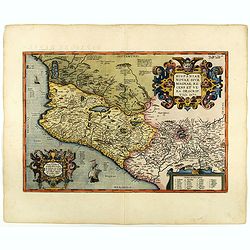
Hispaniae novae sive magnae recens et vera descriptio. 1579
This was the standard map of the area for a generation, copied by De Bry, Quad and Hondius. Even though Herrera (Spain's Royal Cosmographer) and Wytfliet worked 20 years ...
Date: Antwerp, 1598
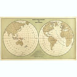
Radio Wereld Kaart om Hollandia.
Poster showing a world map in a double hemisphere projection. Showing distances from New Guinee to other parts of the world. The year 1939 at the outbreak of the Second W...
Date: The Netherlands, 1939
Selling price: ????
Please login to see price!
Sold in 2025
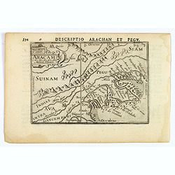
Aracam.
A rare miniature map of Thailand and Burma. Title cartouche on the upper left corner. First published in 1598 in his 'Caert-Thresoor', the plates were executed by the mos...
Date: Amsterdam, 1606
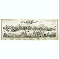
Candie.
A panoramic view, showing the Turkish siege of Candia, with a numbered key (1-33) at the bottom locating 33 points of interest. of Crete coast and the Turkish vessels (33...
Date: Amsterdam, ca. 1678
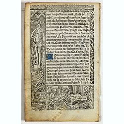
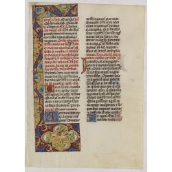
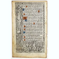
Leaf on vellum from a printed Book of Hours.
24 lines of printed text, surrounded by Renaissance borders decorated with flowers, vases, skeletons and religious scenes.From the press of the leading Parisian publisher...
Date: Paris, Germain Hardouyn, c.1520-1540
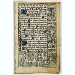
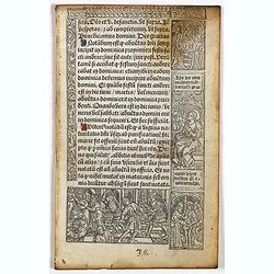
Leaf on vellum from a printed Book of Hours.
24 lines of printed text, surrounded by renaissance borders decorated with flowers, vases and religious scenes.From the press of the leading Parisian publisher and illumi...
Date: Paris, Germain Hardouyn, c.1520-1540
![[Title page from Theatrum orbis Terrarum, with past-on]](/uploads/cache/43860-250x250.jpg)
[Title page from Theatrum orbis Terrarum, with past-on]
The frontispiece of the third part of the 'Theatrum', by Johan Blaeu. Heightened with goldDecorated with terrestrial and celestial globes and to the left Ptolemy (with sp...
Date: Amsterdam, ca. 1650
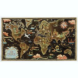
AIR France réseau arérien mondial.
Original lithograph advertising planisphere cardboard from AIR France. The map is designed by Lucien Boucher and is in fact a reduced version of his larger format poster....
Date: Imprimerie Perceval, Paris, 1938
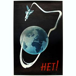
Het! (Nyet! No!).
Original vintage Soviet propaganda poster - Het! (Nyet! No!) - featuring a great illustration of a US space shuttle circling the earth and leaving a trail in the shape of...
Date: Russia, 1985
![Candia [Map of the island Crete]](/uploads/cache/45233-250x250.jpg)
Candia [Map of the island Crete]
Very rare map of the island Crete published in the first edition of "Viaggio da Venetia, a Costantinopoli. Per Mare, e per Terra, & infieme quello di Terra Santa...
Date: Venice, Giacomo Franco, 1598
![Rodi [View of Rhodes]](/uploads/cache/45236-250x250.jpg)
Rodi [View of Rhodes]
Very rare view of the City of Rhodes on the island of Rhodes. Historically, Rhodes island was very famous worldwide for the Colossus of Rhodes, one of the Seven Wonders o...
Date: Venice, Giacomo Franco, 1598

Jerusalem.
Very rare view of Jerusalem published in the first edition of "Viaggio da Venetia, a Costantinopoli. Per Mare, e per Terra, & infieme quello di Terra Santa. Da G...
Date: Venice, Giacomo Franco, 1598
![Stampalia. [Map of Astypalaia]](/uploads/cache/45244-250x250.jpg)
Stampalia. [Map of Astypalaia]
Very rare map of the Greek island Astypalaia. The island is known in Italian as Stampalia. Published in the first edition of "Viaggio da Venetia, a Costantinopoli. P...
Date: Venice, Giacomo Franco, 1598
![[Young lady dancing]](/uploads/cache/46518-250x250.jpg)
[Young lady dancing]
Lovely art deco etching with light hand coloring showing a beautiful lady dancing, and a dog. The artwork is signed in black pencil, but not identifiable.
Date: Paris, ca. 1930

L'Africa divisa nelle sue Parti secondo le pui moderne . . .
A beautiful and rare two-sheet map of Africa. The title cartouche is depicted on a drape surrounded by native animals.A most noticeable feature of the decoration on the m...
Date: Venice, 1690
![[Improve the work of all lines of the transport Conveyor.]](/uploads/cache/47058-250x250.jpg)
[Improve the work of all lines of the transport Conveyor.]
Uncommon Soviet propaganda poster from Kommunar Publishing, located south of Moscow in Tula at 150 Friedrich Engels Street. The publishing house also issued the Kommunar ...
Date: Moscow, 1984
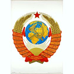
Proletarians of all countries, connect.
Uncommon Soviet propaganda poster.Read more about the Soviet propaganda poster. [+]
Date: Moscow, 1989
![[Two volumes, with two Leo maps] De Bello Belgico, Decas Prima / Decas Secunda.](/uploads/cache/48779-250x250.jpg)
[Two volumes, with two Leo maps] De Bello Belgico, Decas Prima / Decas Secunda.
With 2 engraved titles of the 'Leo Belgicus', with one paw resting on a shield bearing the title, large woodcut printer's device on the colophons, and 30 richly engraved ...
Date: Rome, Franciscus Corbelletus, 1632-1647
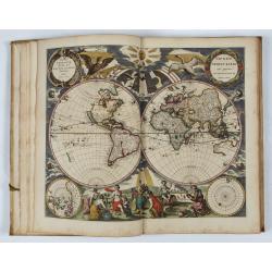
L’Atlas de la Mer ou Monde aquaticque.
Original blind-stamped vellum binding; attractive ORIGINAL HAND-COLOR in outline with cartouches, windroses and decoration in full original color; internally some usual m...
Date: Amsterdam, sur le Cay de Teexel, prez du Rams-Koy, au miroir de la Mer, 1670
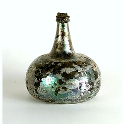
Wine bottle
The Onion-shaped wine bottle is of green glass and is sealed with cork and wax that the cork holds in place. The many years that the bottles spent under the water have l...
Date: Dutch East India Company, Netherlands, ca. 1735-1750
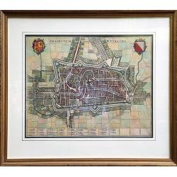
Traiectum Wttrecht
Fine plan of Utrecht from the townbooks "Novum Ac Magnum Theatrum Urbium Belgicae Liberae Ac Foederatae".FRAMED : Additional shipping costs apply. The item is l...
Date: Amsterdam, 1649

Hollandiae pars septentrionalis, Vulgo Westvriesland..
Based on the work of B.F.van Berckenrode, this fine map, orientated west to the top of the sheet, includes Kennemerland and Hollands Noorderkwartier and is a reasonably u...
Date: Amsterdam, ca. 1667
![[ The repositioning of the Vatican obelisk ]](/uploads/cache/49045-250x250.jpg)
[ The repositioning of the Vatican obelisk ]
Joan Blaeu published The Repositioning of the Vatican Obelisk. This large engraving on multiple sheets and in beautiful original colors is based on Domenico Fontana’s d...
Date: Amsterdam, 1649
De Landvoogdy der Moluccos met de Aangrenzende Eylanden . . .
Two charts on one sheet depicting the Moluccas islands. Little interior detail is given but the coastlines, settlements and principal coastal features are identified. To ...
Date: Amsterdam, 1726
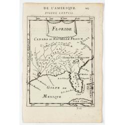
Floride.
A charming map of Florida, also showing Cuba, Golf of Mexico & St Augustine.Title in curtain draped at top. French text on verso.From the original 1683 text edition o...
Date: Paris, 1683
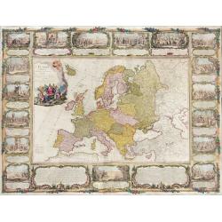
L'Europe divisée en tous ses états, dressée sur les nouveaux mémoires et suivant les dernières observations.
Rare wall map of the European continent, published by the Parisian publisher Sébastien G. Longchamp.The map is surrounded by a magnificent Rococo-style frame decorated w...
Date: Paris, 1757
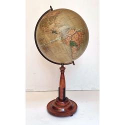
Prof. Dr. A. Krause, Neuer Handels- u. Verkehrsglobus, Verlag Paul Räth.
Art-Deco German Table Globe, on a scale of 1:38 600 000, designed by Prof. Arthur Krause with 30 centimeters in diameter, made by the company Paul Räths, Nachf. KG, Leip...
Date: Leipzig, Paul Räth, ca. 1930

Het Hooge Heemraedtschap van Schielandt.
This beautiful wall map of "Het Hooge Heemraedtschap van Schielandt" is on nine attached leaves (each leaf 49x58,5 cm. ) engraved by J. VINGBOOMS after J.J. STA...
Date: Rotterdam, A. van Hoorn, 1684
![[Title page] Atlas Novus Terrarum Orbis Imperia. . .](/uploads/cache/49113-250x250.jpg)
[Title page] Atlas Novus Terrarum Orbis Imperia. . .
The lovely title page from Homann's Grosser Atlas uber de Gantsa Welt (Grand Atlas of all the World)with striking color and features. It shows Atlas and Hercules / Herakl...
Date: Nuremberg, ca 1737
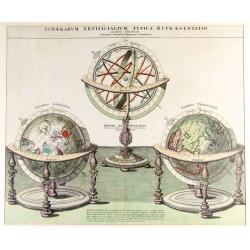
Sphaerarum Artificialium Typica Repraesentatio. . .
Stunning engraving of Homann's terrestrial and celestial globes and armillary sphere, all with highly ornamented stands. Brief explanatory text.Johann Baptist Homann born...
Date: Nuremberg, 1740
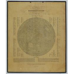
General-Karte der sichtbaren Seite der Mond-oberflaeche zugleich als Übersichts-Blatt zur grössern Mondkarte von Wilh. Beer und Joh: Heinr. Mädler.
An early representation of the viewable surface of the moon by Johann Heinrich Mädler (1794-1874) and Wilhelm Beer (1797-1850).Ignoring the occasional pre-telescopic ap...
Date: Berlin, 1837
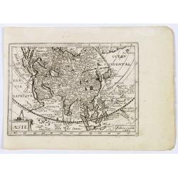
Asie.
This rare map of Asia was published by Jollain in 1667. Published in "Trésor Des Cartes Geographiques Des Principaux Estats de Lunivers".This atlas is based up...
Date: Paris, 1667
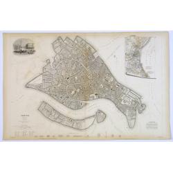
Venice.
A lovely steel engraved plan, on 2 sheets, of Venice by the Society for the Diffusion of Useful Knowledge (SDUK). This English philanthropic enterprise was entirely devot...
Date: London, 1855
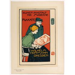
Wilhem Hoffmann Dresden.
Chromo lithographed poster, "Wilhelm Hoffmann Dresden.", after Otto Fischer. Plate 127, published in Maître 32, on July 1898. The "Les Maitres de l'Affich...
Date: Paris, Imprimerie Chaix, April 1896

Portrait de George Washington.
Portrait of the first president of the United States of America.From Giulio Ferrario's work Le Costume ancien et moderne ou histoire du gouvernement, de la milice, de la ...
Date: Milan 1827

A new & accurate map of Louisiana, with part of Florida. . .
An English view of North America compiled from available French maps, especially those of Bellin used in Charlevoix's History of New France. English cartographers had lit...
Date: London, 1744
![Amerique Septentrionale divisée en ses principales parties. . .1685. [California as an Island]](/uploads/cache/60628-250x250.jpg)
Amerique Septentrionale divisée en ses principales parties. . .1685. [California as an Island]
Engraved by Cordier. Spectacular example of Jaillot's map of North America, showing California as an Island, based upon Sanson's landmark map of 1656. This map shows the ...
Date: Paris, 1685
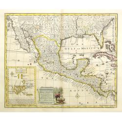
A new and accurate map of Mexico or New Spain with California New Mexico . . .
With inset of Galapagos islands. A wonderfully engraved map showing the entire American South from Carolina to California, as well as all of Mexico and Central America. A...
Date: London, 1747
Manuscript leaf on vellum from a Dutch Book of Hours.
A leaf from a medieval manuscript Book of Hours, written in Utrecht.Fourteen lines of monastic Textura script with 4 two-line initial "I" in liquid gold on a bl...
Date: Utrecht, ca.1450 - 1460
Manuscript leaf on vellum from a Dutch Book of Hours.
A leaf from a medieval manuscript Book of Hours, written in Utrecht.Fourteen lines of monastic Textura script with fourteen 1-line initials in blue or gold with extensive...
Date: Utrecht, ca.1450 - 1460
Leaf on vellum from a manuscript Brevier.
RECTO: One 3-line illuminated initial in burnished gold on colored grounds. Panel border of acanthus leaves, flowers and birds on a partly liquid gold and dark red ground...
Date: Tours, c.1485

Map of Pensylvania and New Jersey by H.S. Tanner.
First edition of this rare and important map of Pennsylvania and New Jersey by H.S. Tanner and published in his "New American Atlas" from 1823. Includes roads, ...
Date: Philadelphia, Henry Tanner, 1823

A new & accurate map of the Empire of China from the Sieur Robert's Atlas. With improvements.
An excellent early engraving of China and Korea that appeared in Sieur Robert de Vaugondy's Geographical Dictionary (London: 1759). Decorative title cartouche on the uppe...
Date: London, 1759
![Etats-Unis de L'Amerique Septentrionale. [Two sheets in manuscript ]](/uploads/cache/03972-250x250.jpg)
Etats-Unis de L'Amerique Septentrionale. [Two sheets in manuscript ]
Two sheets giving detailed information in French about the population in 1810, principal cities, products of industry and commerce, the financial situation for 1818, etc....
Date: France, ca. 1819
De Kust van Nova Guinea tot aan deze bogt . . .
De kust van Nova Guinea tot aan deze bogt.De Kust van Nova Guinea ofte Salomon Sweers hoek. Het Landt van Nova Guinea in de Groote Bocht daar wy vergeefs hoopten een doo...
Date: Amsterdam, 1726

Asia secundum legitimas projectionis stereographicae.
Highlighted area covers part of Spain, eastern coast of Ireland to western part of Papua New Guinea and the Asian continent from the Northern Polar Sea to the Indian Ocea...
Date: Nurenberg, 1744

Carte de la Mer Rouge, depuis Moka jusqu's Gedda. . . .
Chart of the Red Sea. With 3 inset maps of Shake Omare, Goofs and Gedan. D'Après De Mannevillette (1707-1780) was one of France's first hydrographers. When the first edi...
Date: Paris, 1753
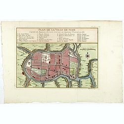
Plan de la ville de Siam.
Early plan of Siam, Thailand. Across the top is an extensive list of 22 important sites and locations keyed to the plan with tiny letters and numbers.Jacques Nicolaas Bel...
Date: Paris, 1750
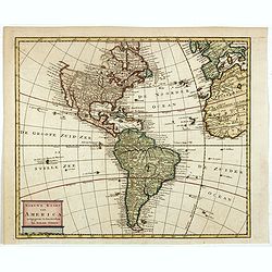
Nieuwe kaart van America.
An attractive map of both the Americas, by one of the leading mapmakers in 18th century Amsterdam. Isaak Tirion (d. 1769) was a Amsterdam publisher. His "Nieuwe en b...
Date: Amsterdam, 1765
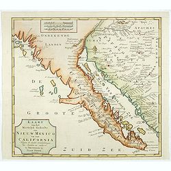
Kaart van het Westelyk Gedeelte van Nieuw Mexico en van California. . . MDCCLXV ..
A detailed map of the Baja California and Sonora, bounded on the north by the Colorado and Gila Rivers and approximately Mozatlan in the south, thus including parts of mo...
Date: Amsterdam, 1765
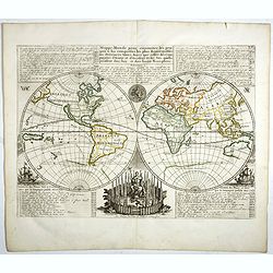
Mappe-Monde pour connoitre les progres & les conquestes..
Unusual double hemisphere map with California as an Island. Dutch text describes the expeditions and colonial possessions of the Dutch East India Company. The map origina...
Date: Amsterdam, 1729
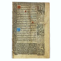
Leaf on vellum from a printed Book of Hours.
21 lines of printed text, surrounded by Renaissance borders decorated with flowers and little miniatures with figures on both sides.From the press of the leading Parisian...
Date: Paris, Germain Hardouyn, c. 1520-1540
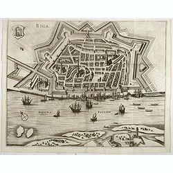
Riga.
Decorative view of Riga. This well executed engraving was published in 1729 and 1727 by Pieter van der AA, in Leiden in "Les Voyages tres-curieux et tres-renommez fa...
Date: Leiden, 1719
Leaf on vellum from a printed Book of Hours In Latin and French.
24 lines of printed text, surrounded by renaissance borders decorated with flowers, vases and figures. Gothic type, text in Latin, numerous one and two-line initials in g...
Date: Paris, Germain Hardouyn, c. 1520-1540
Leaf on vellum from a printed Book of Hours In Latin and French.
24 lines of printed text, surrounded by renaissance borders decorated with flowers, vases and figures. Gothic type, text in Latin, numerous one and two-line initials in g...
Date: Paris, Germain Hardouyn, c. 1520-1540

Charte von China und den angränzenden Ländern und Völkerschaften so wie den letzten Kaiser Tschien-Long. . .
Uncommon map of China on a scale of ca. 1:6,000,000. The map's complete title is “Charte von China und den angränzenden Ländern, und Völkerschaften so wie sie dem le...
Date: Parague, 1812
Selling price: ????
Please login to see price!
Sold in 2023
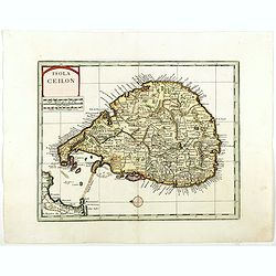
Isola Ceilon.
Attractive copper engraved map of Sri Lanka showing mountains, Towns and the Rama's Bridge (Ponte di Adamo). Included in "Atlante Novissimo che Contiene Tutte le Par...
Date: Venice, 1740
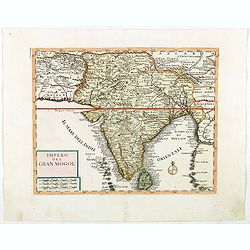
Impero del Gran Mogol.
Attractive copper engraved map of India with Sri Lanka. Showing mountains, towns and the Rama's Bridge (Ponte di Adamo). Included in "Atlante Novissimo che Contiene ...
Date: Venice, 1740