Recently Listed Listings
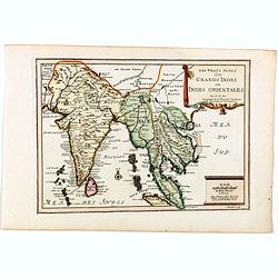
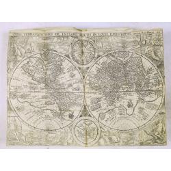
Les Vrays Indes dits Grands Indes ou Indes Orientales Par N. de Fer. Geographe de Sa Majeste Catoliques et de Monseigneur le Dauphin.
Detailed map on India, Thailand, the Malay Peninsular and the south coast of China up to Macao. The map was engraved by C. Inselin.
Date: Paris, 1705
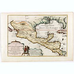
Le vieux Mexique ou nouvelle Espagne. . .
Attractive map covering the Gulf of Mexico through Central America also including parts of Cuba and Jamaica. It extends through Mexico to show the southern tip of Baja Ca...
Date: Paris, 1705
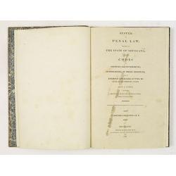
System of Penal Law, prepared for the State of Louisiana , comprising codes of offenses and punishments, of procedure, of prison discipline, and of evidence applicable as well to civil as to criminal cases.
The "Enquiries" of Rush and Bradford and the Pennsylvania movement toward abolition of the death penalty had a little immediate impact on the practices of other...
Date: New-Orleans, Benjamin Levy, 1824
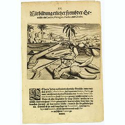
Plants, including the canior, diringuo, pucho and chiabe.
In the Indies there are many delightful plants, which include the ‘costus indicus’ (named by the Malays 'pucho') that has a wonderful aroma. Then there is the ‘cala...
Date: Frankfurt, 1598
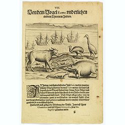
The bird called 'Eeme' and other creatures of India.
Especially on the island of Java and in India, a strange bird called an 'Eeme' is found. It is almost as large as an ostrich with strong and sturdy legs, but it has no to...
Date: Frankfurt, 1598
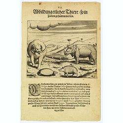
Some of the animals that are found in India.
Although most elephants are found in Ethiopia, there are also many in India too. They are called 'Caffres' by the inhabitants and are slaughtered for their tusks, which t...
Date: Frankfurt, 1598

Carte des Isles du Japon Sequels est remarque la Route..
This uncommon map of Japan, a reduced version of his larger map, contains comments about the nature of the country. For instance, Ocsaqui (Okazaki, near Nagoya) is said t...
Date: Paris / Amsterdam, 1679

Provincia ecclesiastica di Malines nel Belgio (Tav LXII)
This large-format map of Belgium with its different dioceses. The map is finely engraved and beautifully colored and was prepared by Girolamo Petri, a lawyer who served a...
Date: Rome, 1858

A Hysterical Map of the Yellowstone Park. . .
A funny 1936 pictorial map of Yellowstone Park, that was 'hatched and scratched' by the American printer and humourist Jolly Elmer Lindgren. This wonderful map covers the...
Date: Spokane, 1936
![[Atlas] Images du Monde. Atlas Illustré.](/uploads/cache/44610-250x250.jpg)
[Atlas] Images du Monde. Atlas Illustré.
In original green publishers green covered cloth covers, complete with a contents table and 33 pictorial maps of countries of the world (including continents and a world ...
Date: Paris, 1942
Selling price: ????
Please login to see price!
Sold in 2025
![[Fan shaped shopping guide to Stockholm.]](/uploads/cache/44788-250x250.jpg)
[Fan shaped shopping guide to Stockholm.]
A highly unusual and interesting vintage fan-shaped map of Stockholm to illustrate a 'Shopping guide to Stockholm'. Text written in English. With ten fold-out panels prin...
Date: Stockholm, 1960
![[Map of Corfu. View of the city of Corfu on the foreground. ]](/uploads/cache/45221-250x250.jpg)
[Map of Corfu. View of the city of Corfu on the foreground. ]
Very rare map of Corfu with a view of the city of Corfu on the foreground. Published in the first edition of "Viaggio da Venetia, a Costantinopoli. Per Mare, e per T...
Date: Venice, Giacomo Franco, 1598
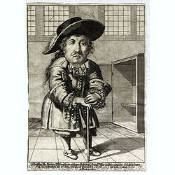
Abbild des sehr kleinen Männleins auß der Schweitz Hans Worrenberg genant, ist lang zwei Fuß und sieben zoll, alt 36 Jahr wie zu Hamburg Anno 1687 im Majo und Junio gesehen worden.
Engraving showing Hans Worrenberg, a dwarf of Switzerland at an age of 36 in the year of 1687. Worrenberg was actor and active in Hamburg 1687 and London 1688. The engrav...
Date: Hamburg, ca.1689
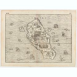
Sumatra.
Gastaldi prepared this map and it was the first separate map of any Southeast Asian island based on actual observation. The general contour of Sumatra is remarkably good ...
Date: Venice, 1556
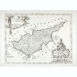
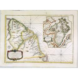
Acamantis insula hogidi Cipro . . .
Decorative map of Cyprus. The remarkable Vincenzo Coronelli (1650-1718), was a Franciscan Friar and appointed General of the Order in 1701. He was cosmographer to the Rep...
Date: Venice, 1700
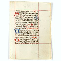
A leaf from a breviary.
Two large 2-line initials in red and or blue for the start of the new chapter.Nice clean leaves, with ample margins, from a breviary, end of the 15th. century.
Date: Northern Netherlands ?, ca. 1480
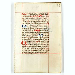
A leaf from a breviary.
Two large 2-line initials in red and or blue for the start of the new chapter.Nice clean leaves, with ample margins, from a breviary, end of the 15th. century.
Date: Northern Netherlands ?, ca. 1480
![[Cloth Map of Europe]](/uploads/cache/47148-250x250.jpg)
[Cloth Map of Europe]
Anglo-centric cloth map of Europe produced during WWI.Serbia, the spark that lit the conflagration of World War One, isn’t even labeled on this interesting cloth map of...
Date: London, c. 1915
![[Goose game board] Le 1914 Edition pochette.](/uploads/cache/47214-250x250.jpg)
[Goose game board] Le 1914 Edition pochette.
Goose game in the form of a folding map of north of France and Belgium, with part of England, Germany, Holland and Luxembourg.More about board games [+]
Date: Paris, 1914
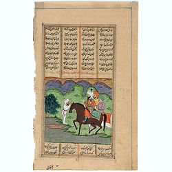
Persian miniature paintings, Mogul Dynasty.
Indo/Persian, Mogul Dynasty miniature painting in delicate Opaque watercolors on paper, with Islamic scripts on recto and verso. Miniature about 135 x 150mm. Painted in g...
Date: Northern Indian Mogul dynasty, ca 1800-1850
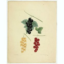
Black, Dutch Red and White Current.
Color aquatint and stipple engraved plate of fruits by George Brookshaw (1751-1823) from his "Pomona Britannica; or, a Collection of the most esteemed fruits at pres...
Date: London, Bensley and son, 1817
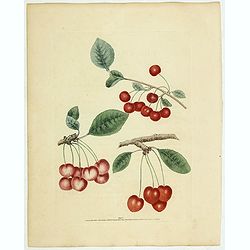
Cherries.
Color aquatint and stipple engraved plate of fruits by George Brookshaw (1751-1823) from his "Pomona Britannica; or, a Collection of the most esteemed fruits at pres...
Date: London, Bensley and son, 1817
Cherries.
Color aquatint and stipple engraved plate of fruits by George Brookshaw (1751-1823) from his "Pomona Britannica; or, a Collection of the most esteemed fruits at pres...
Date: London, Bensley and son, 1817
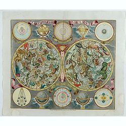
Planisphaerum coeleste.
A very decorative double hemisphere celestial chart. The 10 smaller circular diagram showing the rotation of the Planets, according to Tycho Brahe, Ptolemy and Copernicus...
Date: Nurenberg, 1750
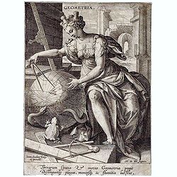
Geometria, from The Seven Liberal Arts.
A female figure with a castle on her head measures a globe with a compass; representing geometry. Engraving by Johann Sadeler I after M. de Vos.
Date: Antwerp, 1570 - 1600
![Ch'onha chido.[Atlas of all under Heaven]](/uploads/cache/44639composition-world-250x250.jpg)
Ch'onha chido.[Atlas of all under Heaven]
A late 18th-century Ch'onha chido atlas with 13 woodblock maps showing the World, China, Korea, Japan, Okinawa, and the 8 provinces. The seas are in black.Slight wear, co...
Date: Korea, ca. 1760
Atlas de Géographie Physique, Politique, Ancienne et Moderne contenant les cartes générales et particulières toutes les parties du Monde.
Complete with title page, contents page, and all 35 double-page maps of European and regional maps of the world, including Oceania, the Americas, Asia, Africa, etc. All i...
Date: Paris, 1875
Selling price: ????
Please login to see price!
Sold in 2024

Plan du Cap de Bonne-Esperance et ses environs..
Large and detailed sea chart of the Cape of Good Hope from Saldahna Bay to False Bay.Engraved by Guillaume-Nicolas Delahaye (1727-1802).Latitude and longitude scales, com...
Date: Paris, 1745

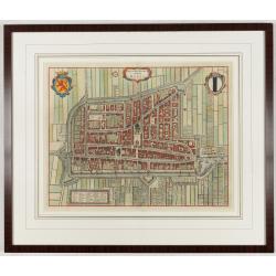
Curia Hollandiae Interior. (Binnenhof)
The government center of the Netherlands is situated in and around the Binnenhof-Buitenhof in The Hague. In 1248 the Roman king Willem II built a castle here and named it...
Date: Amsterdam, 1649

Pascaarte, van de Zuijderzee, Vliestroom, Vlie, en Amelandergat…
Very rare chart of the Dutch Zuiderzee, here in its rare 5th state (o f6). Showing the coastlines along the Dutch inner sea. Two compass roses indicate north to the left ...
Date: Amsterdam, c. 1660
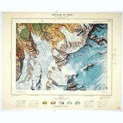
Aiguille du Midi - Mont Blanc N°1 Nord.
Magnificent 1:10,000 scale color printed map of L'Aiguille du Midi (Mont Blanc N°1 Nord) based on stereotopographic ground and aerial surveys carried out in the field in...
Date: Paris, 1953
![[Lot of 9 maps] Plan général de Sébastopol avec indication des travaux du siege et de la defense au 28 mars - 9 avril 1855. Feuille 10. xiii](/uploads/cache/33907-250x250.jpg)
[Lot of 9 maps] Plan général de Sébastopol avec indication des travaux du siege et de la defense au 28 mars - 9 avril 1855. Feuille 10. xiii
A group of nine (of 14) very rare panoramic town-plans of the siege of Sebastopol or maps of the Crimea. In lower margin : "Gravé au Dépôt topographique de la Gue...
Date: St. Petersburg, N. Thieblin, 1863
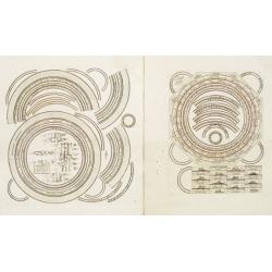
Two sheets for constructing an armillary sphere.
Two sheets for constructing an armillary sphere. Cassini was a geographer and cartographer, but also perspective and architecture carver - one of Giovanni Battista Pirane...
Date: Rome, 1795
Carte de la Guyane Françoise et l'Isle de Cayenne..
A well engraved and highly detailed chart of French Guiana and the island of Cayenne. Made in 1763 by Jacques Bellin (1703-72), a prolific cartographer assigned the Minis...
Date: Paris, 1763

Nuova carta dell' Imperio della Chia e dei Paesi circonvicini. / Nueva carta de l'Impario de la Quina.
The map is of interest for the use of Mar di Corea" and "Mar Setentrionale del Giapone" in the sea between Korea and Japan.Rare early edition of Albrizzi's...
Date: Venice, 1740

La Saxe Contenant le Routes et les postes. . .
Fine post-route map of Saxony in Germany with a splendidly engraved title cartouche. The map is centered on Leipzig. George Louis Le Rouge was active between 1740 and 178...
Date: Paris, 1756
Selling price: ????
Please login to see price!
Sold in 2025

Habillement de l'Empereur de la Chine & des Dames de son Palais..
This impressive engraving is a wonderful example of Chatelain’s elegant plates.Divided in 3 panels, showing examples of costumes of Chinese ladies and those of the king...
Date: Amsterdam, ca. 1728

Vue de la ville et du château de Heidelberg . . . Ansicht der stadt und des schlosses Heidelberger . . .
Engraving after Louis Charles François de Graimberg-Belleau. Engraved by Ch. Haldennvang.French artist. Son of Gilles-François Belleau Graimberg. Louis Charles Françoi...
Date: Graimberg, Heidelberg, ca. 1840

Insulae Indiae Orientalis.
Map of South East Asia with good detail on the Philippines from the rare Cloppenburg edition slightly larger format and more scarce edition of the Mercator/Hondius "...
Date: Amsterdam, 1630

Ormus (Straits of Hormus)
A lovely miniature map of the Kingdom of Ormus, published by Petrus Bertius, and published in Amsterdam at the beginning of the seventeenth century. With an attractive st...
Date: Amsterdam, 1606
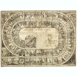
Jeu Royal de la vie d'Henri IV.
Large sheet with an animated Goose-game of 63 numbered squares, spiral, counterclockwise, centripetal focused on the French king Henri IV.André Basset offers the life of...
Date: Paris, ca. 1816-1820
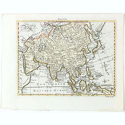
Asia.
Detailed map the Asian continent. The map is of interest for the use of Sea of Corea, the sea between Korea and Japan.
Date: Amsterdam, 1682
Selling price: ????
Please login to see price!
Sold in 2023
![[Title page from ] Le Theatre du Monde ou le nouvel atlas mis en lumière par Guillaume et Jean Blaeu. La seconde partie de la premiere.](/uploads/cache/47929-250x250.jpg)
[Title page from ] Le Theatre du Monde ou le nouvel atlas mis en lumière par Guillaume et Jean Blaeu. La seconde partie de la premiere.
Frontispiece of the second part of the first part of this fine atlas. At top, a coat of arms surmounted by a crown and surrounded by two golden chains, the bigger carryin...
Date: Amsterdam, 1644
![[Title page for] Recueil de cartes sur la geographie ancienne . . .](/uploads/cache/47729-250x250.jpg)
[Title page for] Recueil de cartes sur la geographie ancienne . . .
Title-frontispiece of "Recueil de cartes sur la geographie ancienne", published by Rigobert Bonne in 1783, engraved by Louis Legrand.More about title pages [+]
Date: Paris, 1783
![[Title page for ] Atlas de la Terre ou Monde Terrestre - Tome premier]](/uploads/cache/47761-250x250.jpg)
[Title page for ] Atlas de la Terre ou Monde Terrestre - Tome premier]
Title page of " Atlas de la Terre ou Monde Terrestre - Tome premier" by J. Jansonius. This is the updated version of 1:42B. The figures of the king, queen, daup...
Date: Amsterdam, after 1650
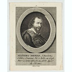
M.Merian, l'Ancien célébre graveur . . .
Portrait of Matthäus Merian (1593-1650) by Hubert. Matthäus Merian der Ältere was a Swiss-born engraver who worked in Frankfurt for most of his career, where he also ...
Date: Paris, 1784
![[Title page] Atlas Tot Amsterdam Bij Iustus Danckers in de Calverstraet inde Damcbaerhrijt.](/uploads/cache/47920-250x250.jpg)
[Title page] Atlas Tot Amsterdam Bij Iustus Danckers in de Calverstraet inde Damcbaerhrijt.
Decorative title page with the figure of Atlas, standing on a globe of the Old World. The left and bottom right corners have animals and people from different parts of th...
Date: Amsterdam, ca. 1680
Selling price: ????
Please login to see price!
Sold in 2024
![[Title page from ] Le Theatre du Monde ou le nouvel atlas mis en lumière par Guillaume et Jean Blaeu. La seconde partie de la seconde.](/uploads/cache/47923-250x250.jpg)
[Title page from ] Le Theatre du Monde ou le nouvel atlas mis en lumière par Guillaume et Jean Blaeu. La seconde partie de la seconde.
Frontispiece of the second part of the second part of this fine atlas. At top, a coat of arms surmounted by a crown and surrounded by two golden chains, the bigger carryi...
Date: Amsterdam, 1644
![[Title page from ] Le Theatre du Monde ou le nouvel atlas mis en lumière par Guillaume et Jean Blaeu.](/uploads/cache/47924-250x250.jpg)
[Title page from ] Le Theatre du Monde ou le nouvel atlas mis en lumière par Guillaume et Jean Blaeu.
Frontispiece of the second part of this fine atlas. At top, a coat of arms surmounted by a crown and surrounded by two golden chains, the bigger carrying a pendant which ...
Date: Amsterdam, 1644
Histoire de la Navigation.
A fine example of Linschoten's classic illustrated travelogue to the East and West Indies, termed by Lach “the most important of the firsthand accounts published indepe...
Date: Amsterdam, Evert Cloppenburgh, 1638
![[Title page] Atlas Minor Praecipua Orbis Terrarum Imperia, Regna et Provincias , Germaniae Potissimum. . .](/uploads/cache/48479-250x250.jpg)
[Title page] Atlas Minor Praecipua Orbis Terrarum Imperia, Regna et Provincias , Germaniae Potissimum. . .
An attractive and highly decorative title page to Seutter's Atlas Minor. Engraved by Martin Crophius after Jacob Weyerman. The engraving is packed with lively figures fro...
Date: Augsburg, 1744
Quartum Praelium Coniovian inter et Fluvium Rio Grande XVII Ian
Decorative engraving of the fourth sea battle with the Portuguese fleet offshore at the Rio Grande, in1640. Engraved by J. van Brosterhuyzen after a design by Frans J. Po...
Date: Joannes Blaeu, Amsterdam 1647
![[Lot of 4 charts] Plan de la Baie et du Port de Camraigne / Plan de la Baie de Niatrang et du Golfe de Binkang / Plan de la Cote de Cochinchine. . . / Plan des Ports de Xuandai, Vung-Lam. . .](/uploads/cache/44795A-250x250.jpg)
[Lot of 4 charts] Plan de la Baie et du Port de Camraigne / Plan de la Baie de Niatrang et du Golfe de Binkang / Plan de la Cote de Cochinchine. . . / Plan des Ports de Xuandai, Vung-Lam. . .
[A set of four French sea charts numbered consecutively]. A set of 4 basic coastal sea charts of parts of southern French Indochina (Vietnam).Chart 295 centers on the reg...
Date: Paris ca 1780
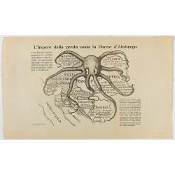
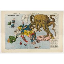
L'Impero della preda ossia la Piovra d'Absburgo.
Austro-Hungarian Octopus zinc lithographed map. A propaganda sheet attacking the Austro-Hungarian Empire, showing it as an octopus with its tentacles wrapped around the v...
Date: La Zincografia, Milan, c. 1915
Set of four continents.
Fine set of 4 continents prepared by Gerard Mercator. The general map of Europe, as well as Americae Pars, Greenland, Iceland, a Polar landmass, along with the mythical i...
Date: Amsterdam, 1628
![[Title page] Voyage de découvertes aux terres Australes . . . Deuxieme partie.](/uploads/cache/46363-250x250.jpg)
[Title page] Voyage de découvertes aux terres Australes . . . Deuxieme partie.
Title page of the atlas Voyage de découvertes aux terres Australes by François Péron, 1824. The French expedition under Nicolas Baudin, was commissioned to chart the c...
Date: Paris, 1807-1816
Delfi Batavorum vernacule Delft.
Detailed plan of the city Delft from Frederick de Wit's town book of the Netherlands. The plates are first published by Joan Blaeu one year after the peace of Münster an...
Date: Amsterdam, 1698
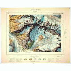
Aiguille verte - Chamonix N°6 Sud
Magnificent 1:10,000 scale color printed map of l'Aiguille verte (Chamonix N°6 Sud) based on stereotopographic ground and aerial surveys carried out in the field in 1950...
Date: Paris, 1953
La Piovra Russa. Carta Serio-Comica Pel 1878.
Variant of the very rare political caricature map by Grossi of the nations of Europe, published in Bologna in the supplement of the newspaper "Le Perroquet / Al papa...
Date: Bologne presso il Giornale colorato in Papagallo, 1878

Provincie Noord-Braband. / Breda, de Langstraat. . .
Decorative and uncommon custume plate lithographed by R. de Vries and published by Frans Buffa & Zonen in Amsterdam. A group of 4 women from the area of Baronie van B...
Date: Amsterdam, 1857
![Figure 27 deuxieme partie a gauche.. [Hors riding].](/uploads/cache/14160-250x250.jpg)
Figure 27 deuxieme partie a gauche.. [Hors riding].
This fabulous illustration depicts formal movements of equitation for horse riding school movements. The print shows both A.de Pluvinel and the future King at the age of ...
Date: Paris, 1629
![Figure 38 troisieme partie. [Hors riding]](/uploads/cache/14164-250x250.jpg)
Figure 38 troisieme partie. [Hors riding]
This fabulous illustration depicts formal movements of equitation for horse riding school movements. The print shows both A.de Pluvinel and the future King at the age of ...
Date: Paris, 1629

Simori.
Portrait of Simori.Von Siebold was born in Wurtzburg, in Germany, and worked for the Dutch government as a doctor in Java. In Japan, where Von Siebold arrived in 1823 at ...
Date: Leiden, 1832-1852

Globe Terrestre Didié et Présénté a Monseigneur le Comté Maubec de Brancas...
A rare terrestrial globe dated 1741. Complete title "Globe Terrestre Didié et Présénté a Monseigneur le Comté Maubec de Brancas Par Jacque Hardy. Dres...
Date: Paris, dated 1741

Forest scene on the Tobihanna Alleghany Mountains.
Original aquatint engraving for Travels in the Interior of North America between 1832-34 . Engraved by L.Weber. The finest work on American Indian life and the American F...
Date: London/Paris/Coblenz, 1839
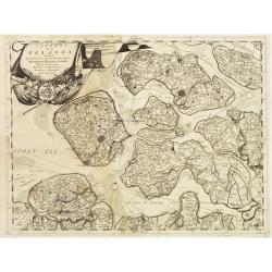
Contado di Zelanda..
A most attractive and decorative map by Vincenzo Coronelli. An elaborate title cartouche garlanded with intertwined flowers and dedicated to Vincenzo Caualli. The remarka...
Date: Venice 1692
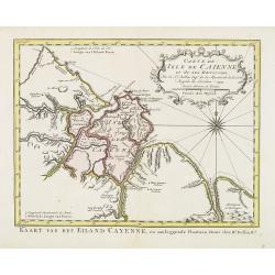
Carte de L'Isle de Caiene et de ses environs.
Uncommon edition of this accurate map of Cayenne. In lower right engraved "31."From Atlas Portatif pour servir a l'intelligence de l'Histoire Philosophique et P...
Date: Amsterdam, 1773
![[Perspective print after J. Vredeman de Vries. ]](/uploads/cache/26445-250x250.jpg)
[Perspective print after J. Vredeman de Vries. ]
Engraving depicting the use of the vanishing point. From Les cinq rangs de l'architecture, a savoir, Tuscane, dorique, ionique, corinthiaque et composée avec l'instructi...
Date: The Hague, 1606
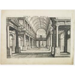
Perspective print by Vredeman de Vries.
Engraving from Les cinq rangs de l'architecture, a savoir, Tuscane, dorique, ionique, corinthiaque et composée avec l'instruction fondamentale. by Paul Vredeman de Vries...
Date: The Hague, 1606
Perspective print by Vredeman de Vries.
Engraving from Les cinq rangs de l'architecture, a savoir, Tuscane, dorique, ionique, corinthiaque et composée avec l'instruction fondamentale. by Paul Vredeman de Vries...
Date: The Hague, 1606
Kasteel Heeswijk.
Very fine etching of the Castle of Heeswijk, by the well-known etcher Ludwig Willem Reymert Wenckebach. He was born in The Hague on 12 January 1860 and died in 1937. The ...
Date: Amsterdam, 1901

Porte de Harlem (Heemstede/Haarlem)
Showing the Haarlemmer Poort (gate) in Heemstede near Haarlem. Likely published by Mondhard, who was a well-known publisher of optical prints, established in rue St.Marti...
Date: Paris, ca. 1750

Vue générale d'Amsterdam.
A so-called optical prints, showing Amsterdam seen from the IJ. A lively scene with extensive shipping. To the left the headquarters of the V.O.C., nowadays the Maritime ...
Date: Paris, ca. 1750

Vue du village de Maarsen en Hollande.
Showing the river Vecht at the town of Maarsen. Published by Jacques Chereau, who was a well-known publisher of optical prints, established in rue St. Jacques in Paris. I...
Date: Paris, ca. 1750
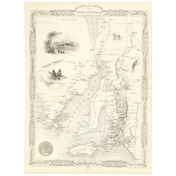
Part of South Australia.
Decorative steel engraved map of part of South Australia, surrounded by illustrations of Adelaide, natives on a catamaran, an Australian dog and a nymphicus bird illustra...
Date: London, ca. 1851
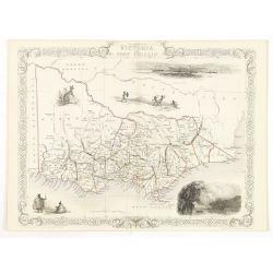
Victoria or Port Phillip.
Decorative steel engraved map of Victoria or Port Phillip, surrounded by illustrations of Melbourne, indigenous people and the Glenelg River. Interlocking border design. ...
Date: London, ca. 1851

Australia.
Decorative steel engraved map of Australia, surrounded by illustrations of Sydney harbor, birds, kangaroos and local people. Interlocking border design. Taken from "...
Date: London, ca. 1851

Das Hertzogthum Braband. . .
Charming map of the Dutch and Belgium province of Brabant. With a fine cartouche.
Date: Leipzig, 1749
Harlekin en Bombario en den rouw.
Harlequin and Bombario in mourning, taken from Het groote tafereel der dwaasheid : vertoonende de opkomst, voortgang en ondergang der actie, bubbel en windnegotie, in Vra...
Date: Amsterdam, 1720
Bronwater of geneesmiddel voor de zieke actionisten.
Springwater or potion for the sick shareholder, taken from Het groote tafereel der dwaasheid : vertoonende de opkomst, voortgang en ondergang der actie, bubbel en windneg...
Date: Amsterdam, 1720