Subscribe to be notified if similar examples become available.
![[A unique, made-to-order edition, of the Parergon, in quo Veteris geographiae aliquot tabulae.]](/uploads/cache/49049-250x250.jpg)
![[A unique, made-to-order edition, of the Parergon, in quo Veteris geographiae aliquot tabulae.]](/uploads/cache/49049AAA-250x250.jpg)
![[A unique, made-to-order edition, of the Parergon, in quo Veteris geographiae aliquot tabulae.]](/uploads/cache/49049Asignatire-250x250.jpg)
![[A unique, made-to-order edition, of the Parergon, in quo Veteris geographiae aliquot tabulae.]](/uploads/cache/49049D-250x250.jpg)
![[A unique, made-to-order edition, of the Parergon, in quo Veteris geographiae aliquot tabulae.]](/uploads/cache/49049C-250x250.jpg)
![[A unique, made-to-order edition, of the Parergon, in quo Veteris geographiae aliquot tabulae.]](/uploads/cache/49049BBB-250x250.jpg)
![[A unique, made-to-order edition, of the Parergon, in quo Veteris geographiae aliquot tabulae.]](/uploads/cache/49049F-250x250.jpg)
![[A unique, made-to-order edition, of the Parergon, in quo Veteris geographiae aliquot tabulae.]](/uploads/cache/49049G-250x250.jpg)
![[A unique, made-to-order edition, of the Parergon, in quo Veteris geographiae aliquot tabulae.]](/uploads/cache/49049E-250x250.jpg)
![[A unique, made-to-order edition, of the Parergon, in quo Veteris geographiae aliquot tabulae.]](/uploads/cache/49049H-250x250.jpg)
![[A unique, made-to-order edition, of the Parergon, in quo Veteris geographiae aliquot tabulae.]](/uploads/cache/49049I-250x250.jpg)
![[A unique, made-to-order edition, of the Parergon, in quo Veteris geographiae aliquot tabulae.]](/uploads/cache/49049K-250x250.jpg)
![[A unique, made-to-order edition, of the Parergon, in quo Veteris geographiae aliquot tabulae.]](/uploads/cache/49049J-250x250.jpg)
![[A unique, made-to-order edition, of the Parergon, in quo Veteris geographiae aliquot tabulae.]](/uploads/cache/49049M-250x250.jpg)
![[A unique, made-to-order edition, of the Parergon, in quo Veteris geographiae aliquot tabulae.]](/uploads/cache/49049L-250x250.jpg)
![[A unique, made-to-order edition, of the Parergon, in quo Veteris geographiae aliquot tabulae.]](/uploads/cache/49049P-250x250.jpg)
![[A unique, made-to-order edition, of the Parergon, in quo Veteris geographiae aliquot tabulae.]](/uploads/cache/49049O-250x250.jpg)
![[A unique, made-to-order edition, of the Parergon, in quo Veteris geographiae aliquot tabulae.]](/uploads/cache/49049T-250x250.jpg)
![[A unique, made-to-order edition, of the Parergon, in quo Veteris geographiae aliquot tabulae.]](/uploads/cache/49049N-250x250.jpg)
![[A unique, made-to-order edition, of the Parergon, in quo Veteris geographiae aliquot tabulae.]](/uploads/cache/49049Q-250x250.jpg)
![[A unique, made-to-order edition, of the Parergon, in quo Veteris geographiae aliquot tabulae.]](/uploads/cache/49049S-250x250.jpg)
![[A unique, made-to-order edition, of the Parergon, in quo Veteris geographiae aliquot tabulae.]](/uploads/cache/49049V-250x250.jpg)
![[A unique, made-to-order edition, of the Parergon, in quo Veteris geographiae aliquot tabulae.]](/uploads/cache/49049Z-250x250.jpg)
![[A unique, made-to-order edition, of the Parergon, in quo Veteris geographiae aliquot tabulae.]](/uploads/cache/49049W-250x250.jpg)
![[A unique, made-to-order edition, of the Parergon, in quo Veteris geographiae aliquot tabulae.]](/uploads/cache/49049R-250x250.jpg)
![[A unique, made-to-order edition, of the Parergon, in quo Veteris geographiae aliquot tabulae.]](/uploads/cache/49049Y-250x250.jpg)
![[A unique, made-to-order edition, of the Parergon, in quo Veteris geographiae aliquot tabulae.]](/uploads/cache/49049ZC-250x250.jpg)
![[A unique, made-to-order edition, of the Parergon, in quo Veteris geographiae aliquot tabulae.]](/uploads/cache/49049ZB-250x250.jpg)
![[A unique, made-to-order edition, of the Parergon, in quo Veteris geographiae aliquot tabulae.]](/uploads/cache/49049U-250x250.jpg)
![[A unique, made-to-order edition, of the Parergon, in quo Veteris geographiae aliquot tabulae.]](/uploads/cache/49049ZA-250x250.jpg)
![[A unique, made-to-order edition, of the Parergon, in quo Veteris geographiae aliquot tabulae.]](/uploads/cache/49049ZD-250x250.jpg)
![[A unique, made-to-order edition, of the Parergon, in quo Veteris geographiae aliquot tabulae.]](/uploads/cache/49049ZE-250x250.jpg)
![[A unique, made-to-order edition, of the Parergon, in quo Veteris geographiae aliquot tabulae.]](/uploads/cache/49049ZF-250x250.jpg)
[A unique, made-to-order edition, of the Parergon, in quo Veteris geographiae aliquot tabulae.] |
||||||||||||||||||||
|
||||||||||||||||||||
|
|
||||||||||||||||||||
|
|
My Collection + - Save and collect this or any of your favorite items in one place.
If you want to save the items permanently, please sign in or create account first. |
|||||||||||||||||||
Description
This is a unique, made-to-order atlas of Ortelius's Atlas, "Parergon" or "Atlas of the ancient world." In 1579, Ortelius published his first Parergon (a series of maps illustrating ancient history, sacred and secular).Koeman mentioned about the Parergon of Ortelius: This atlas of ancient
geography must be regarded as a personal work of Ortelius. For this work
he did not, as in the 'Theatrum', copy other people's maps but drew the
originals himself which were later engraved by Jan Wierix … The maps
in the Parergon have to be evaluated as the most outstanding engravings
depicting the widespread interest in classical geography in the 16th
century. In its final form, the Parergon was printed in 1642 as a
separate book by Balthasar Moretus and was also bound together with the
1612 Latin Theatrum (P. van der Krogt, Atlantes Neerlandici, volume
3,31:055)
This atlas is a specially ordered composition containing 30 maps without text on the verso; 27 maps are from the "Parergon" and 3 by Van Lochom, all maps have blank versos and are printed on strong paper.
On the verso of the first map is a contemporary manuscript index of the included maps, written in brown ink. The maps are numbered on the recto in brown ink; according to this list,According to the states, our Paregon maps can be dated from 1601 onwards and before 1624.
The only known example of an atlas with Parergon maps without printed text on the verso is an atlas of 25 maps quoted by van der Krogt in Atlantes Neerlandici (31:79) and dated ca. 1600; it comprises 20 Parergon maps and five additional maps. (Stuttgart, Würtembergische Landesbibliothek, HBFb 284)
Our example has three added maps by Michel van Lochom’s; the maps can be dated ca. 1640.
On the verso of the first map is a contemporary manuscript index of the included maps, written in brown ink. The maps are numbered on the recto in brown ink; according to this list,
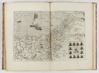
- Peregrinatio Israelitarum per desertum in terram promissam (rare)
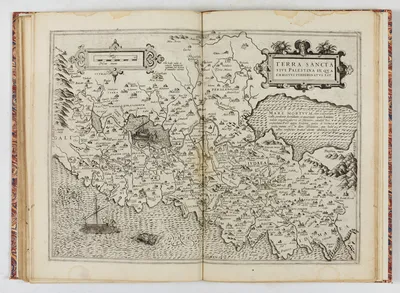
- Terra Sancta sive Palestina in qua Christus peregrinatus est (very rare).
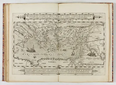
- Peregrinationis divi Pauli typus corographicus ? (no other example known). Based upon Ortelius.
Michel van Lochom was born in Antwerp in 1601. He became a member of the Guild of St Luke in Antwerp in 1613, where he was a pupil of Abraham van Merlen. He became a master of the guild in 1621. He moved to Paris in 1625, working as an engraver and print publisher until 1647.
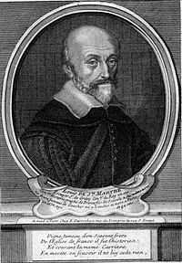
There were joint contributions between the Plantin publishing house and Louis de Sainte-Marthe. Louis possibly bought the remaining maps without text from the Plantin House.
Louis de Sainte-Marth was very interested in the Holy Land and collaborated with the Benedictines Jean Chenu and Claude Robert on the monumental "Gallia Christiana" and likely added the three van Lochom maps after his return to Paris around or after 1640, when the van Lochum maps were published.
The Parergon’s maps can be dated ca. 1601 :
- 1 Europa
- 3 Britannica insula
- 5 Hispania
- 7 Gallia julii Caesaris
- 9 Gallia
- 11 Belgium
- 13 Germania
- 15 Pannonia & Illyricum
- 17 Daeciae & Moesia
- 20 Thracia
- 22 Pontus Euxinus
- 24 Italia
- 26 Graecia
- 28 Graecia Major
- 30 Italia Gallica sive Gallia Cisalpina
- 32 Tuscia
- 34 Latium
- 36 Sicilia
- 38 Corsica, Etna Sardinia, Creta
- 40 Cyprus, multaque, alio insula
- 42 Africa proprie dicta
- 44 Aegyptus antiqua
- 46 Erythra sive Rubri maris Periplus
- 48 Peregrinatio Israelitorum in deserto
- 50 Terra Sancta in qua Christus peregrinatus
- 52 Typus Chorographicus celebrium locorum in regno Judae et Israelis
- 54 Peregrinatio Divi Pauli
- 56 Argonautica
- 58 Alexandri Macedonis Expeditio
- 60 Romanum Imperium
Three maps by van Lochom c. 1640 :
- Peregrinatio Israelitarum per desertum in terram promissam (rare)
- Terra Sancta sive Palestina in qua Christus peregrinatus est (very rare).
- Peregrinationis divi Pauli typus corographicus ? (no other example known). Based upon Ortelius.
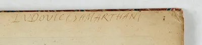 Louis de Sainte-Marthe (Loudun 1571- 1656), also written Louis de Saincte-Marthe or Ludovicus Sammarthanus. Historian, genealogist, historiographer, royal advisor. - Son of Scévole I and twin brother of Scévole II.
Louis de Sainte-Marthe belonged to the Sainte-Marthe family, a group of renowned humanists and scholars who flourished in France between the 16th and 18th centuries. The son of Scévole I (1536-1623), an illustrious poet and politician from Poitou, he began his humanist studies with his twin brother, Scévole, in Poitiers.
Later, the two brothers studied law in Angers. President de Thou made his rich library available to the young people. Louis and his brother Scévole devoted themselves to historiographical research. With his brother, he was appointed historian to the king in 1620 and began with the Histoire généalogique de la Maison de France, which was a great success.
The two continued with the Histoire généalogique de la maison de La Trémoïlle. Finally, they collaborated with the Benedictines Jean Chenu and Claude Robert on the monumental "Gallia Christiana" (1656).
Reference: See Koeman/van der Krogt, IIIA, 31:79. - Laor, 447
FAQ - Guarantee - Shipping
Buying in the BuyNow Gallery
This item is available for immediate purchase when a "Add to Cart" or "Inquire Now" button is shown.
Items are sold in the EU margin scheme
Payments are accepted in Euros or US Dollars.
Authenticity Guarantee
 We provide professional descriptions, condition report (based on 45 years experience in the map business)
Paulus Swaen warrants the authenticity of our items and a certificate of authenticity is provided for each acquired lot.
Condition and Coloring
We indicate the condition of each item and use our unnique HiBCoR grading system in which four key items determine a map's value: Historical Importance, Beauty, Condition/Coloring and Rarity.
Color Key
We offer many maps in their original black and white condition. We do not systematically color-up maps to make them more sellable to the general public or buyer.
Copper engraved or wood block maps are always hand colored. Maps were initially colored for aesthetic reasons and to improve readability. Nowadays, it is becoming a challenge to find maps in their original colors and are therefor more valuable.
We use the following color keys in our catalog:
Original colors; mean that the colors have been applied around the time the map was issued.
Original o/l colors; means the map has only the borders colored at the time of publication.
Colored; If the colors are applied recently or at the end of the 20th century.
Read more about coloring of maps [+]
Shipping fee
A flat shipping fee of $ 30 is added to each shipment by DHL within Europe and North America. This covers : International Priority shipping, Packing and Insurance (up to the invoice amount).
Shipments to Asia are $ 40 and rest of the world $50
We charge only one shipping fee when you have been successful on multiple items or when you want to combine gallery and auction purchases.
Read more about invoicing and shipping
FAQ
Please have a look for more information about buying in the BuyNow gallery
Many answers are likely to find in the general help section.
My Collection+
![]()
With My Collection+ you can collect all your favorite items in one place. It is free, and anyone can create his or her virtual collection.
Unless you are logged in, the item is only saved for this session. You have to be registed and logged-in if you want to save this item permanently to My Collection+.
Read More[+]
Register here, it is free and you do not need a credit card.
Add this item to
My Collection+
or click the following link to see My Collection+.
| Digital Image Download | |
|
Paulus Swaen maintains an archive of most of our high-resolution rare maps, prints, posters and medieval manuscript scans. We make them freely available for download and study. Read more about free image download |
Click the image for a free small image download. |
![Rare, antique map of [A unique, made-to-order edition, of the Parergon, in quo Veteris geographiae aliquot tabulae.]](/uploads/49049.jpg)
![Rare, antique map of [A unique, made-to-order edition, of the Parergon, in quo Veteris geographiae aliquot tabulae.]](/uploads/49049AAA.jpg)
![Rare, antique map of [A unique, made-to-order edition, of the Parergon, in quo Veteris geographiae aliquot tabulae.]](/uploads/49049Asignatire.jpg)
![Rare, antique map of [A unique, made-to-order edition, of the Parergon, in quo Veteris geographiae aliquot tabulae.]](/uploads/49049D.jpg)
![Rare, antique map of [A unique, made-to-order edition, of the Parergon, in quo Veteris geographiae aliquot tabulae.]](/uploads/49049C.jpg)
![Rare, antique map of [A unique, made-to-order edition, of the Parergon, in quo Veteris geographiae aliquot tabulae.]](/uploads/49049BBB.jpg)
![Rare, antique map of [A unique, made-to-order edition, of the Parergon, in quo Veteris geographiae aliquot tabulae.]](/uploads/49049F.jpg)
![Rare, antique map of [A unique, made-to-order edition, of the Parergon, in quo Veteris geographiae aliquot tabulae.]](/uploads/49049G.jpg)
![Rare, antique map of [A unique, made-to-order edition, of the Parergon, in quo Veteris geographiae aliquot tabulae.]](/uploads/49049E.jpg)
![Rare, antique map of [A unique, made-to-order edition, of the Parergon, in quo Veteris geographiae aliquot tabulae.]](/uploads/49049H.jpg)
![Rare, antique map of [A unique, made-to-order edition, of the Parergon, in quo Veteris geographiae aliquot tabulae.]](/uploads/49049I.jpg)
![Rare, antique map of [A unique, made-to-order edition, of the Parergon, in quo Veteris geographiae aliquot tabulae.]](/uploads/49049K.jpg)
![Rare, antique map of [A unique, made-to-order edition, of the Parergon, in quo Veteris geographiae aliquot tabulae.]](/uploads/49049J.jpg)
![Rare, antique map of [A unique, made-to-order edition, of the Parergon, in quo Veteris geographiae aliquot tabulae.]](/uploads/49049M.jpg)
![Rare, antique map of [A unique, made-to-order edition, of the Parergon, in quo Veteris geographiae aliquot tabulae.]](/uploads/49049L.jpg)
![Rare, antique map of [A unique, made-to-order edition, of the Parergon, in quo Veteris geographiae aliquot tabulae.]](/uploads/49049P.jpg)
![Rare, antique map of [A unique, made-to-order edition, of the Parergon, in quo Veteris geographiae aliquot tabulae.]](/uploads/49049O.jpg)
![Rare, antique map of [A unique, made-to-order edition, of the Parergon, in quo Veteris geographiae aliquot tabulae.]](/uploads/49049T.jpg)
![Rare, antique map of [A unique, made-to-order edition, of the Parergon, in quo Veteris geographiae aliquot tabulae.]](/uploads/49049N.jpg)
![Rare, antique map of [A unique, made-to-order edition, of the Parergon, in quo Veteris geographiae aliquot tabulae.]](/uploads/49049Q.jpg)
![Rare, antique map of [A unique, made-to-order edition, of the Parergon, in quo Veteris geographiae aliquot tabulae.]](/uploads/49049S.jpg)
![Rare, antique map of [A unique, made-to-order edition, of the Parergon, in quo Veteris geographiae aliquot tabulae.]](/uploads/49049V.jpg)
![Rare, antique map of [A unique, made-to-order edition, of the Parergon, in quo Veteris geographiae aliquot tabulae.]](/uploads/49049Z.jpg)
![Rare, antique map of [A unique, made-to-order edition, of the Parergon, in quo Veteris geographiae aliquot tabulae.]](/uploads/49049W.jpg)
![Rare, antique map of [A unique, made-to-order edition, of the Parergon, in quo Veteris geographiae aliquot tabulae.]](/uploads/49049R.jpg)
![Rare, antique map of [A unique, made-to-order edition, of the Parergon, in quo Veteris geographiae aliquot tabulae.]](/uploads/49049Y.jpg)
![Rare, antique map of [A unique, made-to-order edition, of the Parergon, in quo Veteris geographiae aliquot tabulae.]](/uploads/49049ZC.jpg)
![Rare, antique map of [A unique, made-to-order edition, of the Parergon, in quo Veteris geographiae aliquot tabulae.]](/uploads/49049ZB.jpg)
![Rare, antique map of [A unique, made-to-order edition, of the Parergon, in quo Veteris geographiae aliquot tabulae.]](/uploads/49049U.jpg)
![Rare, antique map of [A unique, made-to-order edition, of the Parergon, in quo Veteris geographiae aliquot tabulae.]](/uploads/49049ZA.jpg)
![Rare, antique map of [A unique, made-to-order edition, of the Parergon, in quo Veteris geographiae aliquot tabulae.]](/uploads/49049ZD.jpg)
![Rare, antique map of [A unique, made-to-order edition, of the Parergon, in quo Veteris geographiae aliquot tabulae.]](/uploads/49049ZE.jpg)
![Rare, antique map of [A unique, made-to-order edition, of the Parergon, in quo Veteris geographiae aliquot tabulae.]](/uploads/49049ZF.jpg)
In accordance with the EU Consumer Rights Directive and habitually reside in the European Union you have the right to cancel the contract for the purchase of a lot, without giving any reason.
The cancellation period will expire 14 calendar days from the day after the date on which you or a third party (other than the carrier and indicated by you) acquires, physical possession of the lot. To exercise the right to cancel you must inform Paulus Swaen Inc, of your decision to cancel this contract by a clear statement (e.g. a letter sent by post, or e-mail (amsterdam@swaen.com).
To meet the cancellation deadline, it is sufficient for you to send your communication concerning your exercise of the right to cancel before the cancellation period has expired.
