Recently Listed Listings in America
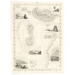
Islands in the Atlantic.
Decorative steel engraved map of Islands showing the Azores, Madeira, Bermuda, the Canaries and the Cape Verdes. Interlocking border design. Taken from "The illustra...
Date: London, ca. 1851

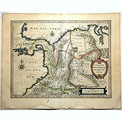
Géographie des Plantes Equinoxiales - Tableau physique des Andes et pays voisins. . .
Physical Portrait of the Andes and adjacent lands", organized around the Chimborazo and Cotopaxi volcanoes in Ecuador.With local vegetation is illustrated pictoriall...
Date: Paris, 1805

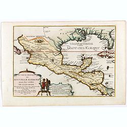
America settentrionale. . .
Rare map of North America drawn directly from the work of Nicholas De Fer and N. Sanson's famous map of 1650. The map is engraved by Antonius Donzel Gallus.With open Grea...
Date: Napels, 1766

L'Amerique Septentrionale.
Very rare map, from "Metaphaste Barbao, Descriptio Indiae Occidentalis et America Nova" published by Henrico Verdussen.The map is a copy of Guillaume de L'Isle'...
Date: Antwerp, 1702

P.les de Virginie.
Attractive copper engraving, depicting a couple of native people of Florida.From the French text edition of Description d'Univers, 1683. by Allain Manneson Mallet (1630-1...
Date: Paris, 1683

Nova Virginia Tabula.
A beautifully engraved map, derived from the highly influential map by Captain John Smith in 1612, showing Chesapeake Bay and the surrounding area. The decoration of this...
Date: Amsterdam, J.Meurs, 1671

Missions et Résidences dans la Partie Septentrionale de l'Amérique Contenant 50 Jésuites.
Very rare missionary map of North America from "Atlas Universel indiquant les établissemens des Jésuites: avec la manière dont ils divisent la terre, suivi desév...
Date: Paris, Ambroise Dupont , 1826

Nieuwe kaart van Kanada . . .
Nice map of the Bay of Hudson, In Labrador, a small inset of Nova Scotia. The map is dated 1769. All text is in Dutch. The map shows the region shortly after the conclusi...
Date: Amsterdam, 1769

Carte de la Nouvelle France, ou se voit le cours des Grandes Rivieres de S. Laurens & de Mississipi..
Derived from de Fer's 1718 map, from west of the Mississippi it contains a mass of inland detail with notes and vignettes of the indigenous peoples and fauna of North Ame...
Date: Amsterdam, 1720
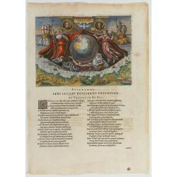
Americae Retectio (Allegory of the Discovery of America)
Allegorical scene commemorating the discovery of America. The main image shows Neptune, supporting a Globe, flanked by Flora-representing Florence, and Janus-representin...
Date: Frankfurt, 1594
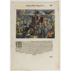
Inventio Maris Magallanici.
Allegorical scene allegorical image celebrating the circumnavigation of the earth by Ferdinand Magellan. The image shows Magellan on board of his ship, surrounded by myth...
Date: Frankfurt, 1594
![[Navel battle between Portuguese and French Battle off Buttugar (Brazil).]](/uploads/cache/48526-250x250.jpg)
[Navel battle between Portuguese and French Battle off Buttugar (Brazil).]
Navel battle between Portuguese and French in the seas off the Poti guaran Territories in Brazil.Read more about "Les Grand Voyages" by Theodore De Bry [+]
Date: Frankfurt, 1594
![Pisces in mari alati [flying fish attack]](/uploads/cache/48527-250x250.jpg)
Pisces in mari alati [flying fish attack]
Flying fish attacking a Portuguese ship in the West Indian Waters.Read more about "Les Grand Voyages" by Theodore De Bry [+]
Date: Frankfurt, 1594
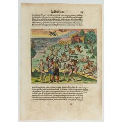
![[The French left in Fort Charles suffer the scarcity of provisions. (Virginia]](/uploads/cache/48529-250x250.jpg)
[The French left in Fort Charles suffer the scarcity of provisions. (Virginia]
An Indian town visited by the French of Charlesfort in search for food. After a drawing by LeMoyne. Charlesfort-Santa Elena is on what is now Parris Island, South Carolin...
Date: Frankfurt, 1594
Cacodemon attacking the savages.
Cacodemon ("evil spirit") attacking the savages. Read more about "Les Grand Voyages" by Theodore De Bry [+]
Date: Frankfurt, 1594

(Island of Pearls) Perlarum insula ob unionum copiam sic dicta.
A depiction of Cubagua as the Perlarum Insula (Island of Pearls), with in the foreground, two large ships send dinghies toward busy Native Americans collecting pearl oyst...
Date: Frankfurt, 1594

Americae Nova Tabula.
The delineation of the coast and the nomenclature on both the Pacific and Atlantic coasts are basically Spanish in origin and follow the maps of Ortelius and Wytfliet. To...
Date: Amsterdam, 1645

Portrait de Benjamin Franklin.
Portrait de Benjamin Franklin. From Giulio Ferrario's work Le Costume ancien et moderne ou histoire du gouvernement, de la milice, de la religion, des arts, etc. publishe...
Date: Milan, 1827
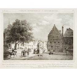
View in Albany-House of the first Dutch Governors.
Decorative print after Jacques Milbert, and lithographed by Tierpenne and the figures by Victor Adam.From Amérique Septentrionale. Printed by de Bove and Noöl ainé &am...
Date: Paris, 1829
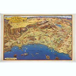
Ride the Roads to Romance along the Golden Coast and thru the Sunshine Empire of Southern California.
Published in 1950 by the Roads to Romance Association to promote tourism in California This striking touring map of Southern California was published in 1950 by the Ro...
Date: California, 1950

Dutton Map of the Grand Canyon, Arizona (in 4 joined sheets)
An important 1882 map of the Grand Canyon, Arizona, published in "Atlas To Accompany The Monograph On The Tertiary History Of The Grand Canon District By Capt. Clare...
Date: Julius Bien and Co., 1882

Mappa Geographica provinciae Nova Ebboraci ab Anglis NEW-YORK dictae. . .
During the Revolution, this map afforded British commanders an excellent overview of areas that would be crucial in the early years of the war, particularly the Hudson Va...
Date: Nuremberg, 1778

ETATS-UNIS DE L'AMÉRIQUE SEPTENTRIONALE Avec LES ISLES ROYALE, DE TERRE NEUVE, DE S.T JEAN, L'ACADIE, &c. 1785. Supplement a l'Atlas de M. Robert de Vaugondy a Paris Ches Boudet Ingenieur du Roi.
A map of the eastern United States with "Supplément à l'atlas de M. Robert de Vaugondy à Paris chez Boudet Imprimeur du Roi", in place of the attribution to ...
Date: Paris, 1785
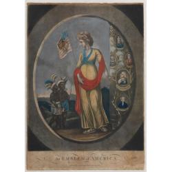
An Emblem of America / An Emblem of Africa / An Emblem of Asia / An Emblem of Europe.
An Emblem of America : This white female figure of Columbia, emblematic of the United States, represents America in a set of prints of the Four Continents. Standing besid...
Date: London, 1798
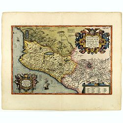
Hispaniae novae sive magnae recens et vera descriptio. 1579
This was the standard map of the area for a generation, copied by De Bry, Quad and Hondius. Even though Herrera (Spain's Royal Cosmographer) and Wytfliet worked 20 years ...
Date: Antwerp, 1598
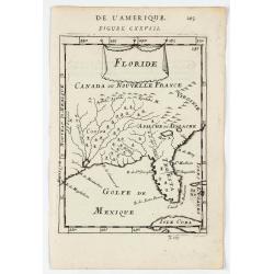
Floride.
A charming map of Florida, also showing Cuba, Golf of Mexico & St Augustine.Title in curtain draped at top. French text on verso.From the original 1683 text edition o...
Date: Paris, 1683

Portrait de George Washington.
Portrait of the first president of the United States of America.From Giulio Ferrario's work Le Costume ancien et moderne ou histoire du gouvernement, de la milice, de la ...
Date: Milan 1827

A new & accurate map of Louisiana, with part of Florida. . .
An English view of North America compiled from available French maps, especially those of Bellin used in Charlevoix's History of New France. English cartographers had lit...
Date: London, 1744
![Amerique Septentrionale divisée en ses principales parties. . .1685. [California as an Island]](/uploads/cache/60628-250x250.jpg)
Amerique Septentrionale divisée en ses principales parties. . .1685. [California as an Island]
Engraved by Cordier. Spectacular example of Jaillot's map of North America, showing California as an Island, based upon Sanson's landmark map of 1656. This map shows the ...
Date: Paris, 1685
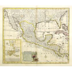
A new and accurate map of Mexico or New Spain with California New Mexico . . .
With inset of Galapagos islands. A wonderfully engraved map showing the entire American South from Carolina to California, as well as all of Mexico and Central America. A...
Date: London, 1747

Map of Pensylvania and New Jersey by H.S. Tanner.
First edition of this rare and important map of Pennsylvania and New Jersey by H.S. Tanner and published in his "New American Atlas" from 1823. Includes roads, ...
Date: Philadelphia, Henry Tanner, 1823
![Etats-Unis de L'Amerique Septentrionale. [Two sheets in manuscript ]](/uploads/cache/03972-250x250.jpg)
Etats-Unis de L'Amerique Septentrionale. [Two sheets in manuscript ]
Two sheets giving detailed information in French about the population in 1810, principal cities, products of industry and commerce, the financial situation for 1818, etc....
Date: France, ca. 1819
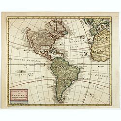
Nieuwe kaart van America.
An attractive map of both the Americas, by one of the leading mapmakers in 18th century Amsterdam. Isaak Tirion (d. 1769) was a Amsterdam publisher. His "Nieuwe en b...
Date: Amsterdam, 1765
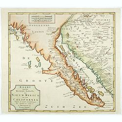
Kaart van het Westelyk Gedeelte van Nieuw Mexico en van California. . . MDCCLXV ..
A detailed map of the Baja California and Sonora, bounded on the north by the Colorado and Gila Rivers and approximately Mozatlan in the south, thus including parts of mo...
Date: Amsterdam, 1765
Le vieux Mexique ou nouvelle Espagne. . .
Attractive map covering the Gulf of Mexico through Central America also including parts of Cuba and Jamaica. It extends through Mexico to show the southern tip of Baja Ca...
Date: Paris, 1705

System of Penal Law, prepared for the State of Louisiana , comprising codes of offenses and punishments, of procedure, of prison discipline, and of evidence applicable as well to civil as to criminal cases.
The "Enquiries" of Rush and Bradford and the Pennsylvania movement toward abolition of the death penalty had a little immediate impact on the practices of other...
Date: New-Orleans, Benjamin Levy, 1824

A Hysterical Map of the Yellowstone Park. . .
A funny 1936 pictorial map of Yellowstone Park, that was 'hatched and scratched' by the American printer and humourist Jolly Elmer Lindgren. This wonderful map covers the...
Date: Spokane, 1936
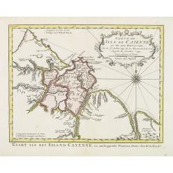
Carte de la Guyane Françoise et l'Isle de Cayenne..
A well engraved and highly detailed chart of French Guiana and the island of Cayenne. Made in 1763 by Jacques Bellin (1703-72), a prolific cartographer assigned the Minis...
Date: Paris, 1763
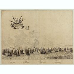
Quartum Praelium Coniovian inter et Fluvium Rio Grande XVII Ian
Decorative engraving of the fourth sea battle with the Portuguese fleet offshore at the Rio Grande, in1640. Engraved by J. van Brosterhuyzen after a design by Frans J. Po...
Date: Joannes Blaeu, Amsterdam 1647

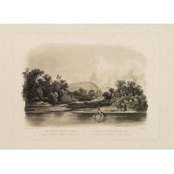
Forest scene on the Tobihanna Alleghany Mountains.
Original aquatint engraving for Travels in the Interior of North America between 1832-34 . Engraved by L.Weber. The finest work on American Indian life and the American F...
Date: London/Paris/Coblenz, 1839
Carte de L'Isle de Caiene et de ses environs.
Uncommon edition of this accurate map of Cayenne. In lower right engraved "31."From Atlas Portatif pour servir a l'intelligence de l'Histoire Philosophique et P...
Date: Amsterdam, 1773

Guaranty Trust Company of New York. Emprunt national 6%.n Souscrivez.
Very decorative propaganda poster with design by Mark All of Paris for "Guaranty Trust Company of New York", a JPMorgan Chase predecessor in order to promote th...
Date: Paris, 1918
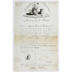
Passeport.
Passport for the United States in the name of Madeleine Lavit Femme Lory, issued by the Commission of Interior Relations and approved by the Committee of Public Safety.Th...
Date: Paris, 1795
![[Printed on silk] Nova Totius Americae Sive Novi Orbis Tabula, Auct. Hugo Allardt.](/uploads/cache/48420-250x250.jpg)
[Printed on silk] Nova Totius Americae Sive Novi Orbis Tabula, Auct. Hugo Allardt.
Hugo Allard’s ca. 1661 map of the Americas, showing California as an island printed on silk. This separately issued map printed on paper is quite rare on the market. T...
Date: Amsterdam, 1661

Avantures du Sr. C. Le Beau, avocat en parlement ou Voyage curieux et nouveau parmi les Sauvages de l'Amérique Septentrionale. Dans lequel on trouvera une Description du Canada… Ouvrage enrichi d'une Carte et des figures necessaires.
A description of Huron, Iroquois, and Algonquin customs, written in charming style and based, the Author claims, on observations made on a trip to America in 1729." ...
Date: Amsterdam, 1738
Waschinga Sahba's Grab.. (Wakonda Creek.)
Original aquatint engraving for Travels in the Interior of North America between 1832-34 . Engraved by Ch. Vogel. The finest work on American Indian life and the American...
Date: London/ Paris/ Coblenz, 1839

Connecticut and Parts adjacent at Amsterdam. .
A nice example of this early map of the state of Connecticut with part of Rhode Island to the east, Long Island to the south, and New York to the east. Rivers, roads, t...
Date: Amsterdam, 1780

Carolinae Floridae nec non Insularum Bahamensium cum partibus adjacentibus delinatio ad Exemplar Londinense in lucem edita . . . Ao. 1755.
The German edition of this map of Carolina, Florida, and the Bahama Islands in full original colors. Published in Seligmann's "Sammlung verschiedener auslaendischer ...
Date: Nuremberg, 1755
Terra Firma et Novum Regnum Granatense et Popayan.
A handsome map of modern-day Panama and Colombia. The cartouches and decoration are colored in an artistic way. Very fine and rare with this type of coloring.From "l...
Date: Amsterdam, 1635-1638

Nieuwe gemeten kaart van de colonie de Berbice met der zelver plantagiën en de namen der Bezitters. . .
Re-issue of his map from 1740, without the printed list of owners, with a large added contemp. hand-colored cartouche Relaas van de rebellie, ontstaan op de plantagien in...
Date: Amsterdam, ca.1763

Pascaerte vande Caribische Eylanden, vande Barbados tot aende Bocht van Mexico ‘t Amsterdam By Hendrick Doncker. . .
First state. Rare. “This chart appeared in the first edition of Hendrick Doncker’s Zee-Atlas, of which no surviving example is known” -- Burden. This is an example ...
Date: Amsterdam, 1659
Carta particolare del'mare del Zur che comincia con il capo S. Francesco nel Peru e finisce con il capo S. Lazaro nella nuova Spagnia.
FIRST EDITION Dudley’s magnificent chart of the Pacific Coast of Central and South America, from the coast of Columbia and Ecuador in the north to the Bay of Honduras i...
Date: Florence 1661
Selling price: ????
Please login to see price!
Sold in 2023

Cunard Cherbourg-New York.
Original vintage Cunard luxury cruise liner travel poster advertising Cunard Europe to all America fastest ocean service in the world. Stunning design featuring two color...
Date: England, ca. 1930

Carte des Possessions Françoises et Angloises dans le Canada, et partie de la Louisiane.
First state of this separately published map of the European Colonies in the New World east of the Mississippi River. This map was published in 1756 to provide informatio...
Date: Paris, 1756

French Line CGT Poster.
French Line CGT Poster showing the Normandie cruise ship travelling from Southampton to New York, advertising an express luxury service on both the Ile de France and the ...
Date: England, ca. 1936
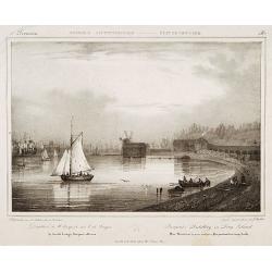
Pierpont's distillery on Long Island.
Milbert's topographical prints are an eyewitness record of life in America in the early 19th centuryDecorative print after Jacques Milbert, and lithographed by Sabatier a...
Date: Paris, 1829
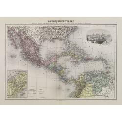
Amérique Centrale.
Decorative map of Central America from Géographie Universelle, Atlas Migeon. With an inset map of the Isthmus of Panama lower left corner and a panoramic view of Mexico ...
Date: Paris, 1874

Sabena (USA - NYC).
Sabena Belgian World Airlines poster showing the skyline of New York in abstract style. Published by Rali Brisart in Belgium.La Sabena, acronym for Societé Anonyme Belg...
Date: Brussels, ca. 1970

Novi Belgii novae que Angliae nec non partis Virginiae..
With the arrival of Dutch and other European colonists, the landscape of New Netherland changed dramatically. The third state, with Fort Kassimier and Philadelphia, and ...
Date: Amsterdam, 1684
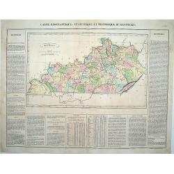
Carte Géographique .. Kentucky.
Detailed map of Kentucky. From J.A. Buchon, "Atlas Gégraphique Statistique, historique et chronologique des deux Ameriques et des isles adjacentes; traduit de l'atl...
Date: Paris, 1825

Rooseveld rekende verkeerd ! De vangarmen van De Dollarpoliep worden afgesneden. . .
A remarkable Anti-American Dutch World War II propaganda poster by Lou Manche, showing a pink octopus representing the United States, with its tentacles cut off in the we...
Date: The Netherlands, 1942

Paraquariae Provinciae Soc. Iesu cum Adjacentibus Novissima...
Between the years of 1609 and 1780, the Jesuits (the Roman Catholic Society of Jesus) established in South America, an autonomous Christian state, on the lands of present...
Date: Augsburg, 1740

Bison Iubatus.
Etching of a bison by Leendert Brasser (1727 - 1793) after a painting of the Dutch artist Gerrit van den Heuvel.An early portrait of a bison, etched by Leendert Brasser (...
Date: Rotterdam, 1766-1793

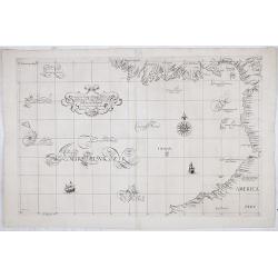
Tabula Magellanica.
A map with Willem Blaeu's signature, but published by his son Joan, of South America's extremity with the Strait of Magellan and Le Maire Strait.The coastlines are depict...
Date: Amsterdam, 1658
![A Toopapaoo of a Chief, with a priest making his offering to the Morai, in Huoheine. [Huaheine - the Society Islands]](/uploads/cache/30045-250x250.jpg)
A Toopapaoo of a Chief, with a priest making his offering to the Morai, in Huoheine. [Huaheine - the Society Islands]
A view of a chief's raised burial chamber in Huaheine, Society Islands, taken from "Views in the South Seas" being a very important and early view depicting sce...
Date: London, Boydell and Co., 1808

Virginie, Grande Region l'Amerique Septentrionale...
Pierre van der Aa used the old copper plate of Meurs and re-did the engraving, changed the large pictorial cartouche, a new scale of German and French leagues is provided...
Date: Amsterdam, 1729
![Mexico, Regia et Celebris Hispaniae Novae Civitas ... [on sheet with] Cusco, Regni Peru in Novo Orbe Caput.](/uploads/cache/29013-250x250.jpg)
Mexico, Regia et Celebris Hispaniae Novae Civitas ... [on sheet with] Cusco, Regni Peru in Novo Orbe Caput.
Two bird's-eye views on one sheet: Mexico and Cusco.Showing Mexico City and Cusco, the capital cities of the Aztecs and Incas, with the major buildings shown in profile w...
Date: Amsterdam, 1657

Carte de LA LOUISIANE et des PAYS VOISINS Dédiée a M. Rouillé Dediee a M. Rouille Secretairr 'd Etat ayant le Departement de la Marine... 1750
North America from the eastern seaboard to the Rocky Mountains. Based on Delisle's map of 1718 with additions from notes compiled by the Jesuit priest, explorer and histo...
Date: Paris, 1750
![Amerique Septentrionale divisée en ses principales parties. . .1692. [California as an Island]](/uploads/cache/27961-250x250.jpg)
Amerique Septentrionale divisée en ses principales parties. . .1692. [California as an Island]
A very good impression of Jaillot's large map of North America, showing California as an Island, based upon Sanson's landmark map of 1656. A first state.The map shows the...
Date: Amsterdam, c.1692

Archipelague du Mexique ou sont les Isles de Cuba..
Scarce map of Caribbean. A visually stunning map with a large title cartouche. This large one-sheet map was produced by the Venetian cosmographer Vincenzo Coronelli when ...
Date: Paris, 1688

Carte Réduite Du Golphe Du Mexique Et Des Isles De L' Amérique..
A well engraved and highly detailed chart prepared by Bellin of the Gulf of Mexico and the Caribbean. In addition to a magnificent title cartouche and a color key to the ...
Date: Paris dated year 17, or 1808

Plan du Port de St Augustin dans la Floride.
This chart shows a plan of the Port of St. Augustine in Florida.The only issue of this version of Bellin's map, slightly larger than the common version. Depths shown by s...
Date: Paris, 1764

Carte qui contient..Iles & Terres..L'Amerique..Jamaique..
Eight maps on one sheet. From Chatelain's Atlas Historique et Méthodique . Including maps of Bermuda, Jamaica, New England with Long Island, Carolina, Chesapeake and Del...
Date: Amsterdam 1728

Paraguay o Prov. de Rio de la Plata cum regionibus adiacentibus Tucuman et Sta. Cruz de la Sierra.
Blaeu's map of the Rio de la Plata region of South America. Originally engraved for Jodocus Hondius II, at his death in August 1629 this map was, among 39 other copper pl...
Date: Amsterdam, 1634

Tabula Americae Specialis Geographica Regni Peru, Brasiliae, Terra Firmae & Reg: Amazonum, Secundum relationes de Herrera, de Laet & PP d Acuña & M. Rodriguez . . .
A good and clean copy of Homann's map of the northern part of South America. The map is on the Valley of the Amazon and delineates the Amazon and its labyrinth of tributa...
Date: Nuremberg, 1728

Typus Geographicus Chili Paraguay Freti Magellanici &c.
Detailed map covering the southern part of the continent based on the cartography of Delisle and the information gleaned from the voyages of Brouwer, Narbouroug and Beauc...
Date: Nuremberg, 1750

Map of Louisiana from D'Anville's Atlas.
This map presents a highly detailed treatment of the region from Cabo Del Norte to the Apalachiola River, centered on the mouth of the Mississippi and extending inland to...
Date: London, 1788

Stoel des Oorlogs in America Waar in Vertoont Werden Alle Desself Voornaamste Eylande . . .
Large impressive map of the West Indies with the Gulf of Mexico and Florida. The map shows prominently in the center Cuba, Haiti, the Bahamas and Florida, which is here m...
Date: Amsterdam, c. 1720

Carte du Mexique et des Etats Unis d'Amérique...
A later edition of De l'Isle's foundation map of 1703, is widely regarded as one of the most influential maps in the history of American Cartography. This updated version...
Date: Paris, 1783

Mapa geogra´fico de la mayor parte de la Ame´rica Meridional que contiene los paises por donde debe trazarse la li´nia divisoria que divida los dominios de Espan~a y Portugal. . .
Rare first edition of the map drawn by Francisco Requena (1743-1824) after his expedition to the Amazon in order to delineate the boundary between the Spanish and Portugu...
Date: Bourquin, F. Philadelphia, ca. 1876