Sign In or Sign Up
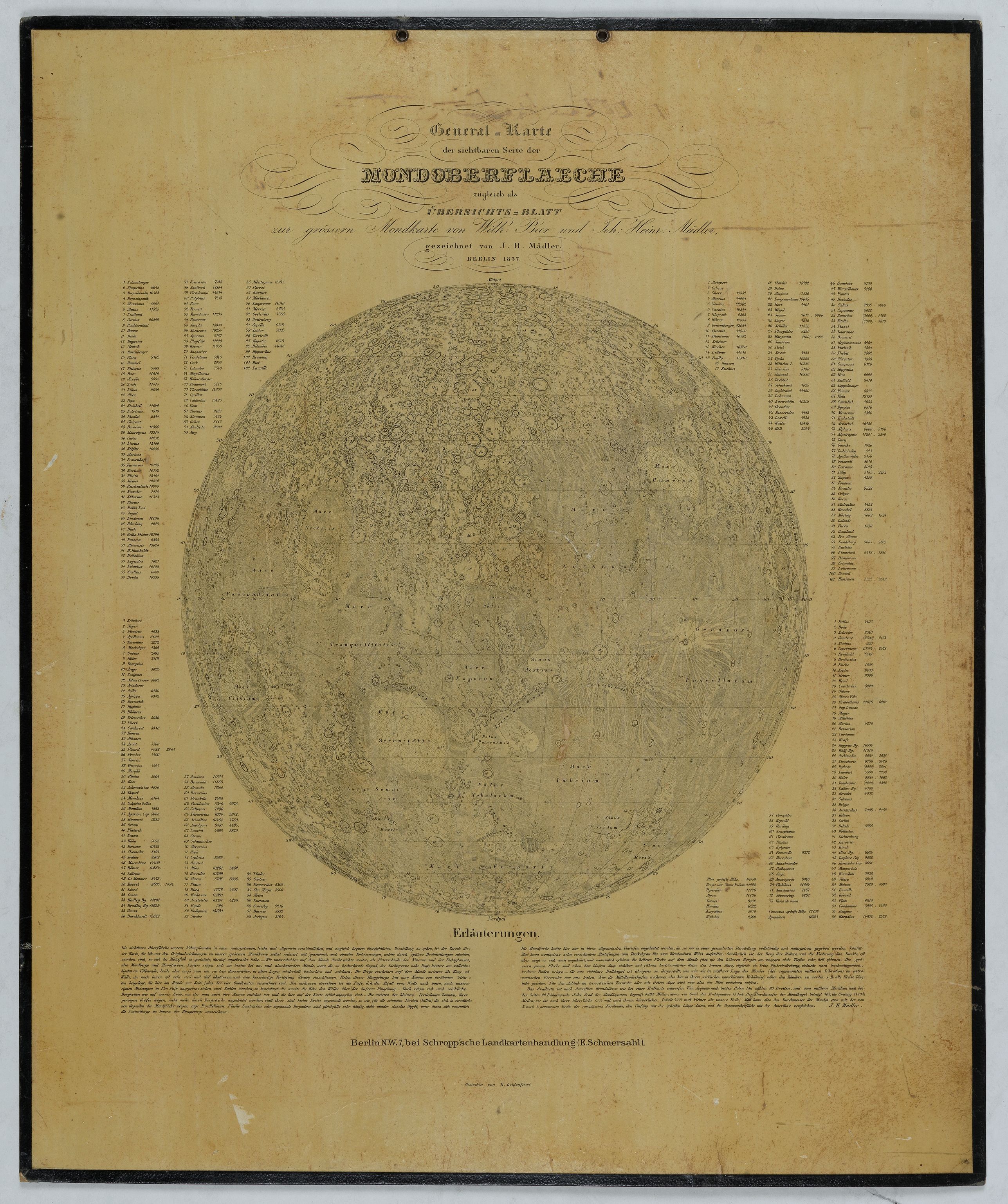
General-Karte der sichtbaren Seite der Mond-oberflaeche zugleich als Übersichts-Blatt zur grössern Mondkarte von Wilh. Beer und Joh: Heinr. Mädler. |
||||||||||||||||||||
|
||||||||||||||||||||
|
|
||||||||||||||||||||
$750 / ≈ €656This item is available for immediate sale! Questions before Buying ?
We are happy to answer your questions.
750.00
|
My Collection +
Add this or any of your favorite items in one place. If you want to save the items permanently, you have to sign in or create an account first. |
|||||||||||||||||||
Description
An early representation of the viewable surface of the moon by Johann Heinrich Mädler (1794-1874) and Wilhelm Beer (1797-1850).
Ignoring the occasional pre-telescopic appearance of exceptionally large sunspots, the Moon is the only heavenly body which shows features to the naked eye--the Man in the Moon. These features are permanent, and it was therefore obvious that the Moon always keeps its same face turned to us (although there are minor perturbations that were not noticed until later).
In 1830, the astronomer Mädler teamed up with Wilhelm Beer, a Berlin banker, to produce their renowned lunar map.
Johann Heinrich von Mädler ( 1794 -1874) is one of the most important German astronomer's of the late 19th century. Madler began giving academic lessons as a private tutor and in this way met Wilhelm Beer, a wealthy banker in 1824. In 1829, Beer decided to set up a private observatory with a 95 mm refractor telescope made by Joseph von Fraunhofer, when Mädler would find his earliest work as an Astronomer.
In 1830, Madler and Beer began producing drawings of Mars which later became the first true maps of that planet.
Madler and Beer also produced the first exact map of the Moon, Mappa Selenographica, published in four volumes in 1834–1836. In 1837, their description of the Moon (Der Mond) was published. Both were the best descriptions of the Moon for many decades, not superseded until the map of Johann Friedrich Julius Schmidt in the 1870s.
Beer and Mädler drew the firm conclusion that the features on the Moon do not change, and there is no atmosphere or water. In 1836, Johann Franz Encke appointed Mädler an observer at the Berlin Observatory. In 1840, Mädler was appointed director of the Dorpat (Tartu) Observatory in Estonia, succeeding Friedrich Wilhelm Struve who had moved to Pulkovo Observatory. He carried out meteorological as well as astronomical observations. He continued Struve's observations of double stars. He remained in Tartu until he retired in 1865, and then returned to Germany.
FAQ - Guarantee - Shipping
Buying in the BuyNow Gallery
This item is available for immediate purchase when a "Add to Cart" or "Inquire Now" button is shown.
Items are sold in the EU margin scheme
Payments are accepted in Euros or US Dollars.
Authenticity Guarantee
 We provide professional descriptions, condition report (based on 45 years experience in the map business)
Paulus Swaen warrants the authenticity of our items and a certificate of authenticity is provided for each acquired lot.
Condition and Coloring
We indicate the condition of each item and use our unnique HiBCoR grading system in which four key items determine a map's value: Historical Importance, Beauty, Condition/Coloring and Rarity.
Color Key
We offer many maps in their original black and white condition. We do not systematically color-up maps to make them more sellable to the general public or buyer.
Copper engraved or wood block maps are always hand colored. Maps were initially colored for aesthetic reasons and to improve readability. Nowadays, it is becoming a challenge to find maps in their original colors and are therefor more valuable.
We use the following color keys in our catalog:
Original colors; mean that the colors have been applied around the time the map was issued.
Original o/l colors; means the map has only the borders colored at the time of publication.
Colored; If the colors are applied recently or at the end of the 20th century.
Read more about coloring of maps [+]
Shipping fee
A flat shipping fee of $ 30 is added to each shipment by DHL within Europe and North America. This covers : International Priority shipping, Packing and Insurance (up to the invoice amount).
Shipments to Asia are $ 40 and rest of the world $50
We charge only one shipping fee when you have been successful on multiple items or when you want to combine gallery and auction purchases.
Read more about invoicing and shipping
FAQ
Please have a look for more information about buying in the BuyNow gallery
Many answers are likely to find in the general help section.
My Collection+
![]()
With My Collection+ you can collect all your favorite items in one place. It is free, and anyone can create his or her virtual collection.
Unless you are logged in, the item is only saved for this session. You have to be registed and logged-in if you want to save this item permanently to My Collection+.
Read More[+]
Register here, it is free and you do not need a credit card.
Add this item to
My Collection+
or click the following link to see My Collection+.
| Digital Image Download | |
|
Paulus Swaen maintains an archive of most of our high-resolution rare maps, prints, posters and medieval manuscript scans. We make them freely available for download and study. Read more about free image download |
Click the image for a free small image download. |
In accordance with the EU Consumer Rights Directive and habitually reside in the European Union you have the right to cancel the contract for the purchase of a lot, without giving any reason.
The cancellation period will expire 14 calendar days from the day after the date on which you or a third party (other than the carrier and indicated by you) acquires, physical possession of the lot. To exercise the right to cancel you must inform Paulus Swaen Inc, of your decision to cancel this contract by a clear statement (e.g. a letter sent by post, or e-mail.
To meet the cancellation deadline, it is sufficient for you to send your communication concerning your exercise of the right to cancel before the cancellation period has expired.
Recently Viewed
General-Karte der sichtbaren Seite der Mond-oberflaeche zugleich als Übersichts-Blatt zur grössern Mondkarte von Wilh. Beer und Joh: Heinr. Mädler.
An early representation of the viewable surface of the moon by Johann Heinrich Mädler (1794-1874) and Wilhelm Beer (1797-1850).Ignoring the occasional pre-telescopic app...
Date: Berlin, 1837

Le temple de la Mecque avec une description de tout ce qu'on y voit . . .
Fascinating engraving depicting the Muslim Kaaba at Mecca. Below the main image are two smaller vignette images of people praying. In between the two vignettes is a key (...
Date: Amsterdam, 1728
Selling price: ????
Please login to see price!
Sold in 2024
