Recently Listed Listings

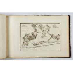
Kaart Van Nieuw Zeeland in de Jaaren 1769 en 1770 bezogt door den Luitenant J. Cook met het Schip De Endeavour.
A uncommon issue of this key map of New Zealand from the Dutch edition of Cook's map of New Zealand, published in 'Reize rondom de Waereld door James Cook', a Dutch editi...
Date: Leyden, Amsterdam & The Hague: Honcoop, Allart & van Cleef, 1795-1801

Leaf on vellum from a antiphonary.
A leaf from a Medieval Antiphonal or Choir Missal for Spanish use, in Latin on extremely heavy vellum. Justification: 360x246mm. Text is in Spanish rounded gothic hand (R...
Date: Sevilla, ca.1520

Leaf on vellum from a antiphonary.
A leaf from a Medieval Antiphonal or Choir Missal for Spanish use, in Latin on extremely heavy vellum. Justification: 360x246mm. Text is in Spanish rounded gothic hand (R...
Date: Sevilla, ca.1520
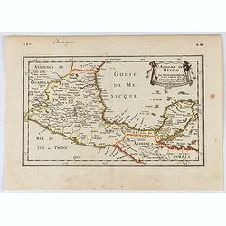
Audience de Mexico.
General map of Mexico after N.Sanson.From the book Nouvelle Relation, Contenant LES VOYAGES DE THOMAS GAGE dans la nouvelle Espagne [..] jusqu'à la Havane, published by ...
Date: Paris, 1756

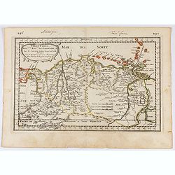
La Floride. . .
The map is derived from La Floride , 1657, by Nicolas Sanson. Several new rivers appear in Virginia. The Caroline listed is Ft. Caroline, not the Carolinas. The Florida n...
Date: Paris, 1683
Terre Ferme, Nouveau Roy.me de Grenade..
Fine map of Colombia, Venezuela and the islands of Curaçao, Aruba, Bonaire, etc. Prepared by N.Sanson engraved by A.de Winter.
Date: Paris, 1656
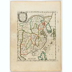
Royaume de la Chine. . .
Detailed map of China. Engraved by A.Winter. Attractive miniature map, depicting Korea as an island and parts of Japan, i.e. western part of Honshu and Kyushu.
Date: Paris, 1656
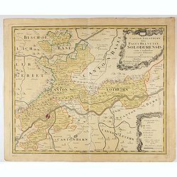
Canton Solothurn sive pagus Helvetiae Solodurensis cum confinibus recenter delineatus per Gabrielem Walserum.
A nice map of Swiss canton centered on Solothurn. Engraved by Tobias C. Lotter.
Date: Augsbourg, 1766
Parte Orientale dell'Elvezia divisa ne'suoi Cantoni di nuova projezione.
Antonio Zatta's detailed map of the eastern part of the Confederation of Switzerland divided into its Cantons. Shows political and administrative boundaries, cities, town...
Date: Venice, 1781
L'Elvezia divisa ne suoi Tredici Cantoni e suoi Alleati di nuova projezione.
Antonio Zatta's detailed map of the Confederation of Switzerland divided into its thirteen Cantons and their allies. Shows political and administrative boundaries, cities...
Date: Venice, 1781
![[Map of river Rhine.]](/uploads/cache/47453-250x250.jpg)
[Map of river Rhine.]
Map of the River Rhine from Boden See until Wesel. Left hand part of a 2-sheet map.
Date: Amsterdam, 1660

Kort begrip der oude en nieuwe staatkundige Geographie: behelzende eene beschryving der heerschappyen, in welken de aarde verdeeld is, haare gelegenheid. . .
Sixth edition- Interesting geographical compendium, prepared by Johann Hubner en W.A. Bachiene. Of particular interest is the section starting with pages 589 with "O...
Date: Amsterdam, Covens / Mortier, Utrecht, Poolsum, 1758
Département de la Drome decreté le 3 février 1790. . .
Map of the region of southeast France. The region of Drome is divided into four districts. On the left, the title with underneath a large explicative text with the divisi...
Date: Paris, 1790-1818

Mappa geographica Provinciæ Nova Eboraci ab Anglis New-York . . .
Lower part of the two sheets map of Homann Heirs' edition of Sauthier's celebrated map of New York and New Jersey, made during the Revolutionary War. Appears in Homann's ...
Date: Nuremburg, 1778

Carte de la partie septentrionale des Etats Unis..
An attractive 1801 map of North America's east coast north of Long Island. Including St.Laurence River as far south as Lake Ontario. Engraved by André and P.F.Tardieu. A...
Date: Paris, 1801
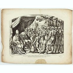
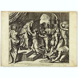
Eleazar sacerdos, et Iosue Rex sorte dividunt in Haereditatem Filiis Israel universam Terram ( Plate 49)
Fine etching by Nicolas Chapron, after Raphaël's (Raffaello Sanzio) frescoes in the Vatican Loggia. Scene illustrating Eleazar and Joshua to divide Canaan among the trib...
Date: Paris, Petrus Mariette, 1649
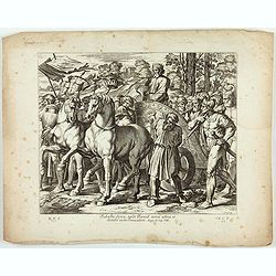
Svbacta Syria, tvlit David arma avrea, et detvlit ea in Jervsalem. ( Plate 43)
Fine etching by Nicolas Chapron, after Raphaël's (Raffaello Sanzio) frescoes in the Vatican Loggia. Scene illustrating David's conquest of Syria, during which he took th...
Date: Paris, Petrus Mariette, 1649
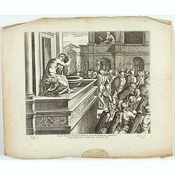
Vidit David de Solario Domus regiae Bethsabeam . . . ( Plate 44)
Fine etching by Nicolas Chapron, after Raphaël's (Raffaello Sanzio) frescoes in the Vatican Loggia. Scene illustrating King David looking at Bathsheba bathing.From the f...
Date: Paris, Petrus Mariette, 1649
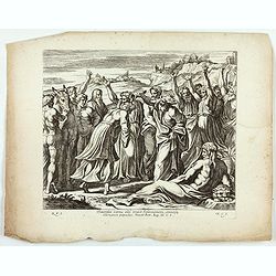
Sacerdos cornu olei unxit Salomonem omnisque clamauit. . . . ( Plate 45)
Fine etching by Nicolas Chapron, after Raphaël's (Raffaello Sanzio) frescoes in the Vatican Loggia. Scene illustrating a priest anointing Solomon with oil.From the first...
Date: Paris, Petrus Mariette, 1649
Saba Aethiopum Regina venit ad Salomonem, cum magnis Opibus aromatum, Auri, ac Gemmarum. ( Plate 47)
Fine etching by Nicolas Chapron, after Raphaël's (Raffaello Sanzio) frescoes in the Vatican Loggia. Scene illustrating the visit of the Queen of Sheba.From the first Par...
Date: Paris, Petrus Mariette, 1649
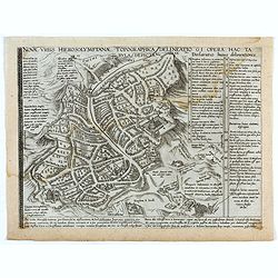
Novae Urbis Hierosolymitanae topographica delineatio . . .
A very rare plan of modern Jerusalem oriented to the east, according to a note on the map the map was drawn after a map by Peter Laicstain. A lettered key to the right.Up...
Date: Antwerp, 1571

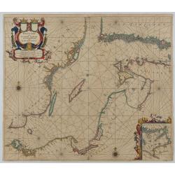
Pas-Caart van de Oost Zee verthooende alle de ghelegenheydt tusschen t Eylandt Rugen ende Wyborg. . .
An eye-catching chart of the Baltic Sea. Engraved by Gerard Coeck.Pieter Goos (ca. 1616-1675) was one of the most important cartographers, engravers, publishers and print...
Date: Amsterdam, 1666
![[Toscana / Tuscany] En, candidi lectores, elegantioris Italiae partis, Tusciae scilicet, topographiam. aenis nris formis excussam in hac Tabella vobis denuo damus. . .](/uploads/cache/47717-250x250.jpg)
[Toscana / Tuscany] En, candidi lectores, elegantioris Italiae partis, Tusciae scilicet, topographiam. aenis nris formis excussam in hac Tabella vobis denuo damus. . .
A rare map of Tuscany, including the islands of Elba, Giglio, Giannutri and part of Corsica, and covering the whole of Tuscany, part of Liguria, Lombardy, Emilia, Umbria,...
Date: Rome, ca 1557

Tierra Nueva.
Uncommon first edition of this early map of the east coast is an enlarged version of Giacomo Gastaldi map published in 1548. Nomenclature and cartography are unchanged, w...
Date: Venice, 1561

Zeelandiae Comitatus.
Rare map of Zeeland, with inset view of the town of Middelburg topped with costumed figures. This is the second edition published by Claes Jansz. Visscher. The first edit...
Date: Amsterdam, 1617-1631
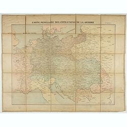
Carte populaire des opérations de la guerre. 2ème édition.
Folding map. War Operations Map showing a part of Europe, published by Epinal.
Date: Paris, ca. 1919

Description geographique, historique, chronologique, politique, et physique de l'empire de la Chine et de la Tartarie chinoise.
First edition of this cornerstone of any collection of books on China, which is also among the rarest and most desirable of important Americana, included in Rare American...
Date: Paris, P. G. Le Mercier, 1735
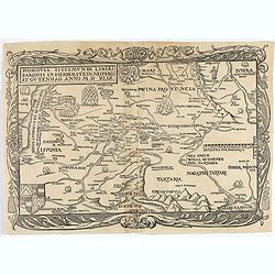
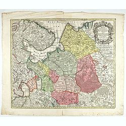
Moscovia Sigismundi Liberi Baronis In Herberstein, Neiperg et Gutehnag Anno M.D XLIX
First Modern Map of Russia. A rare and important cornerstone map for any Russian collection.One of two maps of Russia compiled by Herberstein, who was ambassador from the...
Date: Basle, 1556
Mappae Imperii Moscovitici pars Septentrionalis..
Detailed map of northern Russia embellished with an uncolored pictorial cartouche showing hunting scenes.Prepared by de l'Isle.
Date: Augsburg, 1740
Uffensis Provincia Cum adiacentibus Regionibus.
Volga-Ural Region. From the first regional atlas of Russia, published by the Academy of Sciences in St. Petersburg, expanding on the cartographic work done previously by ...
Date: Academy of Sciences, St. Petersburg, 1745
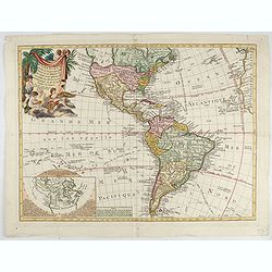
Carte D'Amerique divisée en ses principaux Pays Dressée sur les Mémoires les plus recents, et sur differents Voyages et assujettie aux Observations Astronomiques de Mrs. de l'Academie Royal des Sciences Par Mr. l'Abbe Clouet . . . 1774.
The rare 1774 edition of this fine map of the western hemisphere published by Clouet in Rouen. A later edition with the date 1787 also exists. With inset map "Carte ...
Date: Paris, 1774
![Bamberga. Folium CLXXV [Bamberg]](/uploads/cache/47606-250x250.jpg)
Bamberga. Folium CLXXV [Bamberg]
Double page panoramic view of Bamberg. One of the earliest obtainable views of this period.Two pages from the richest illustrated Incunable, the famous Nuremberg Chronic...
Date: Nuremberg, 12 July 1493

London in Miniature With The Surrounding Villages. An Entire New Plan In which the Improvements both present and intended are actually reduced, by permission, from the surveys of the Several Proprietors. . .
Hand-coloured engraved map, dissected and mounted on linen, orange publishers label on one side, extending west to east from Kensington to East India and Greenwich Dock a...
Date: London, 1821
![[Lot of 7 leaves] Curiensis civitas, Rhetorum…/Valesia/Solothurensis/Clarissimae civitatis/Genevensis/Basiliensis/Ursina…Bernensis/Sedunensis/Designatio …Badensis.](/uploads/cache/48278-250x250.jpg)
[Lot of 7 leaves] Curiensis civitas, Rhetorum…/Valesia/Solothurensis/Clarissimae civitatis/Genevensis/Basiliensis/Ursina…Bernensis/Sedunensis/Designatio …Badensis.
Seven text leaves illustrated with wood block bird's-eye views of Chur, Solothurn, Geneva, Basel, Bern, Sitten, Baden and one single sheet map of the Valais. From the 155...
Date: Basel, 1552
![[Lot of 10 leaves] Catalogus doctorum…in Cosmographia Sebastiani…/ Index Cosmographicus.](/uploads/cache/48294-250x250.jpg)
[Lot of 10 leaves] Catalogus doctorum…in Cosmographia Sebastiani…/ Index Cosmographicus.
Ten leaves with several wood blocks with index taken from the "Cosmographia". From the 1552 Latin text edition of Münster's Cosmographia, which is a short and ...
Date: Basel, 1552
![[Lot of 25 leaves of France, Brabant, Netherlands, Luxemburg]](/uploads/cache/48264-250x250.jpg)
[Lot of 25 leaves of France, Brabant, Netherlands, Luxemburg]
Twenty-five text leaves with wood block illustrations relating to France, Brabant, the Netherlands, Luxemburg. From the 1552 Latin text edition of Münster's Cosmographia...
Date: Basel, 1552
![[Lot of 2 leaves] Vienna Austriae metropolis, urbs…](/uploads/cache/48268-250x250.jpg)
[Lot of 2 leaves] Vienna Austriae metropolis, urbs…
A wood block printed early panoramic view of Vienna (Austria). From the 1552 Latin text edition of Münster's Cosmographia, which is a short and complete summary of Renai...
Date: Basel, 1552

[Lot of 9 leaves with maps and views of Persia and Arabia).
Nineteen text leaves with wood block illustrations relating to Persia and Arabia, from the 1552 Latin text edition of Münster's Cosmographia, which is a short and comple...
Date: Basel, 1552

French composite atlas made up of rare maps published by Parisian editors from the 17th century , mainly by G. Jollain including scarce maps of America.
A rare French composite atlas including 90 maps, published by Parisian publishers from the 17th century, mainly by Gérard I Jollain, or by maps bought from Dutch publish...
Date: Paris, ca. 1675

L'Europe en Sept 1939. Ille terrarum mihi angulus ridet.
A rare oversized serio-comic map of Europe at the start of the Second World War depicting stereotypes of 31 countries, as listed in the key lower right, including Brit...
Date: Bruges, Leon Burghgraeve, 1939
![Madeburga [ Maagdenburg Folio CLXXX ]](/uploads/cache/47601-250x250.jpg)
Madeburga [ Maagdenburg Folio CLXXX ]
Double page panoramic view of Magdeburg. A imaginary view, however the earliest obtainable view of this period.Two page from the richest illustrated Incunable, the famous...
Date: Nuremberg, 12 July 1493
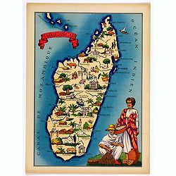
Madagascar.
Very decorative, informative map of Madagascar. The map is filled with buildings, animals, figures and two locals in their typical dress.In lower left corner "Imprim...
Date: France, 1943
![Arcis Carolinae delineatio [Jacksonville]](/uploads/cache/48530-250x250.jpg)
Arcis Carolinae delineatio [Jacksonville]
Depicting Fort Caroline in Jacksonville, Florida. A French expedition, organized by Protestant leader Admiral Gaspard de Coligny and led by the French Explorer Jean Ribau...
Date: Frankfurt, 1594

Latium.
Based on classical authors' sources, specifically Virgilius, Plinius, Varro, Halicarnasseus, Festus and Ausonius.Philip Wingius in his letter to Ortelius from 1592 mentio...
Date: Antwerp, 1595

Chaerte vande Wieringer waert, de welcke inden jaere XVI… (Wieringerwaard)
Rare wall map of the Wieringerwaard polder, as raffled on 12 July 1611. The polder was laid dry in 1610. It border, and the municipality's border, were the Zuiderzee, the...
Date: 1741-1744
![Loandas St.Paulo [Luanda]](/uploads/cache/48500-250x250.jpg)
Loandas St.Paulo [Luanda]
Engraved by Thomas Doesburgh (active between 1683 and 1714) for Carolus Allard's Orbis habitabilis oppida et vestitus, the print shows a distant view of the Angolese ci...
Date: Amsterdam, c. 1685-1690

Nieuwe Wassende Graade Zee Kaart over de Spaanse Zee Vant Kanaal tot 't Eyland Cuba In Westindia.
Rare two-sheet blue-back sea chart of the Atlantic and Eastern part of North America., published by Gerard Van Keulen. The map extends from the latitude of Newfoundland a...
Date: Amsterdam, ca. 1728-1751
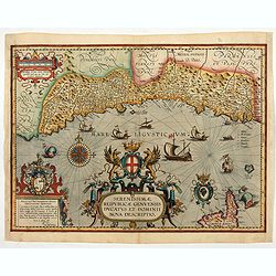
Serenissimae Reipublicae Genuensis Ducatus et Dominii.
Includes the coast of the Riviera from Nice to La Spezia. A most decorative and rare map because it was only included in the Vrients' editions of the Ortelius Theatrum . ...
Date: Antwerp, 1609-1641
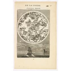
DE LA SPHERE. Figure XXXIV.
A fine celestial map depicting the northern constellations in allegorical form. Fully engraved, it presents two sailing ships and a harbour in the background.From the Fre...
Date: Paris, 1683
Selling price: ????
Please login to see price!
Sold in 2025

Israel.
Decorative poster advertising flights to Israel made by Georges Mathieu. The poster is one of a series of 15 posters of Greece, Israel, Germany, Great Britain, Canada, Eg...
Date: Paris, 1967
Tabulae Italiae, Corsicae, Sardiniae, et adjacentium..
A decorative map by this famous Dutch mapmaker. The border contains views of the main cities, largely inspired by the Civitates Orbis Terrarum by Braun & Hogenberg: R...
Date: Amsterdam, 1628,1640

Paldobundo Province.
Woodblock printed map of Jeolla Province which was one of the historical Eight Provinces of Korea during the Kingdom of The map is drawn in "Paldo Bundo," styl...
Date: 1710-1718
The Pathways of Empire Delineated: Map Showing The Steam Comunication And Overland Routes between England, India, China & Australia…
An illuminating and attractive map that illustrates one of the foundations of British imperial power--the key trade routes by both land and sea between England and its fa...
Date: London, 1856

Wooden Nocturnal in boxwood and brass.
This exceptional nocturnal is made of boxwood and brass, the wheels maintained by a central nut, presents an annual calendar divided into months and days, an hour disc,...
Date: England, Thomas Cooper, dated 1701
![[Drawing of a Tulip]](/uploads/cache/06597-250x250.jpg)
[Drawing of a Tulip]
Very detailed and well executed tulip drawing by an unknown artist belonging to the School of Anthony Claesz (1607/8-1649)This drawing was made for a 'Tulip book' painted...
Date: The Netherlands c.1700

Introduction a la Geographie
Engraved title, with 91 double-page engraved maps mostly including European nations, but including World and continents, Turkey, the Holy Land, Persia, China, Japan, Egyp...
Date: Paris, 1756
Portulano de la Ameririca Setentrional construido en la direccion de tabajos.
The "Portulano de la America Setentrional", is an exceedingly rare Spanish sea atlas featuring charts of the Caribbean and the Gulf of Mexico. It was developed ...
Date: Madrid, 1818
Oost Zee door Arnold Colom.
Large double-page engraved chart of the Baltic Sea, including the coastlines of Finland, Estonia, Latvia, Lithuania, Poland, Denmark, and Sweden, with a decorative inset ...
Date: Amsterdam, c. 1654
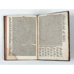
Strabo de situ orbis.
Rare post-incunable 1502 sixth edition of Strabo’s Geographica, translated from Ancient Greek to Latin as De Situ Orbis by Guarino da Verona and Gregorio Tifernate.The ...
Date: Venice, Bartolomeo de Zanis,14th day of January 1502

United States of North America. Carte des Etats-Unis de l'Amerique Septentrionale / copiée et gravée sur celle d'Arrowsmith, corrigée et considérablement augmentée... par P. F. Tardieu...
FIRST EDITION. An impressive wall map here in 4 unjoined sheets and large margins. RARE in these untouched, full sheets. Recorded examples are usually offered as folding ...
Date: Paris: An XI - 1802
![[Two plates on one sheet] Ordinanza Turchesa alla presa di Zigeth in Ongaria l’anno 1566 / Ordinanza Turchesca sotto Viena, contra lo Invictißimo Imperatore Carlo quinto l'anno 1550.](/uploads/cache/49073-250x250.jpg)
[Two plates on one sheet] Ordinanza Turchesa alla presa di Zigeth in Ongaria l’anno 1566 / Ordinanza Turchesca sotto Viena, contra lo Invictißimo Imperatore Carlo quinto l'anno 1550.
Ordinanza Turchesca sotto Viena, contra lo Invictißimo Imperatore Carlo quinto l'anno 1550". C. 1560. This extremely rare plate depicts the order of battle and for...
Date: Venice, 1550/ 1566
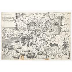
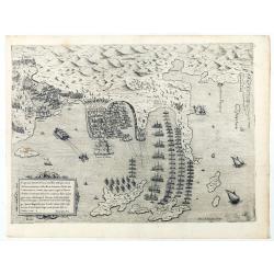
La dimostratione del luogo dove al presente sitrova l'armat di Barbarossa, et de Christiani detto il golfo dell 'Artha anti ch amente il sino ambracio…
The title cartouche at the top left reads: "La Dimostratione Del Luogo Dove Al Presente Sitrova L'Armat Di Barbarossa, et De Christiani Detto Il Golfo Dell' Artha An...
Date: Rome, c. 1540
Disegno dove al presente si ritrova l'armata della santa legha contro la turchesca, nel promontorio della Morea dirincontro a Modon, dove l'armata nemica si è retirata… VI.Ottobre.1572.
Disegno dove al presente si ritrova l'armata della santa legha contro la Turchesca, nel promontorio della Morea dirincontro a Modon dove l'armata nemica si e retirata, lu...
Date: Rome, 1572
![[Map of the coast of Crete to the east of Chania showing the landing of the Turks and the Venetian defence in June 1645].](/uploads/cache/49076-250x250.jpg)
[Map of the coast of Crete to the east of Chania showing the landing of the Turks and the Venetian defence in June 1645].
Map engraved by Marco Boschini (1613-1678). With a lettered key for the Turkish army « A-L » and a numbered key for the city of Chania and its army « 1-20 ».Fifth ...
Date: Venice, c. 1645
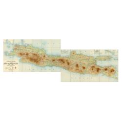
Overzichtskaart van Java en Madoera schaal 1:500.000. Met aanduiding van de politieke indeeling, de organisatie van het bestuur, de bestaande en nog aan te leggen verkeerswegen en van de groote cultuur- en industrieele centra…
If assembled a very large color-printed map (60x 218cm.) of Java and Madoera (Madura Island) on four sheets, each measuring 60 x 54.5 cm, dissected into 12 sections and l...
Date: Atelier Kurkdjian-Soerabaia, 1912
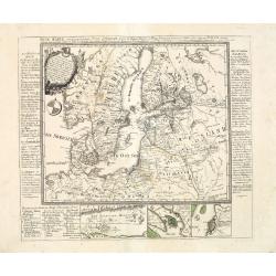
Neue Karte von den gegenwärtigen Kriegs-Schauplatze zwischen den Russisch-Kayserl.
Very rare separately published map showing the Russian War seat including Finland, Lithuania, Denmark and parts of Poland, Norway and Sweden. In lower part inset maps of ...
Date: Leipzig, 1788
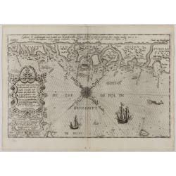
De Zee-Kuste vant Landt te Noort-oosten sorterende onder Norweghen ende eendeels onder Sweden alsoe tlandt aldaer in zijn gedaente is, van Distelberch tot Waersberghe.
A rare Latin text edition of this early and detailed chart of the coast of Norway of this landmark contribution to the science of navigation. Decorated by a large title c...
Date: Leiden, Plantijn, 1585

Rerum per octennium in Brasilia Et alibi nuper gestarum, Sub Praefectura Illustrissimi Comitis I. Mauritii, Nassoviae, (...) Historia.
First edition. Commissioned by Johan Maurits van Nassau (governor of Brazil between 1636-1644 and founder of "Mauritsstad" (present-day Recife)) and illustrated...
Date: Amsterdam, J. Blaeu, 1647
![[Portrait of Gerard Mercator and Jodocus Hondius.]](/uploads/cache/49107-250x250.jpg)
[Portrait of Gerard Mercator and Jodocus Hondius.]
Arguably the finest engraved portrait of early mapmakers. In the well-executed design, Gerard Mercator and Jodocus Hondius are seated within an architectural cartouche of...
Date: Amsterdam, 1630
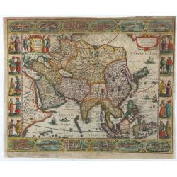
Asia recens summa cura delineata.
This is the rare early issue with decorative paneled borders of four sides. It is surrounded by elaborate borders incorporating twelve bird's eye views of cities and te...
Date: Amsterdam, H.Hondius,1623
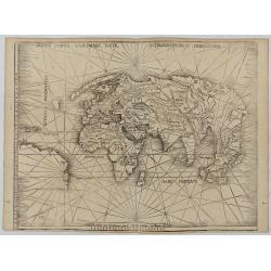
Orbis Typus Universalis Iuxta Hydrographorum Traditionem.
Waldseemüller's monumental modern map of the world from the celebrated Strassbourg edition of Ptolemy's Geography, the most important cartographer of the early sixteenth...
Date: Strasburg, 1513 / 1520
![[Title page] Atlas Nouveau contenant toutes les parties du monde . . .](/uploads/cache/49114-250x250.jpg)
[Title page] Atlas Nouveau contenant toutes les parties du monde . . .
Fine title page of classical architectural design incorporating portraits of royalty and battle scenes.
Date: Paris, 1696
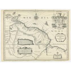
Guiana sive Amazonum regio.
This very rare map shows northwest Latin America with Surinam and French Guiana and was engraved by Johann Philipp Thelott. The map comes from the work of Johann Joachim ...
Date: Frankfurt, 1669
![[Set of 3 optical prints] Vue du Pallais du l'Empereur de Perse avec la Mosquée, ou Eglise a Ispahan.](/uploads/cache/49123-250x250.jpg)
[Set of 3 optical prints] Vue du Pallais du l'Empereur de Perse avec la Mosquée, ou Eglise a Ispahan.
An optical print of the court of the Persian Emperor. Engraved by F.X. Habermann (1721-1796). The Academie Imperiale was a well-known publisher of optical prints establis...
Date: Augsburg, 1750
![[Beatles]](/uploads/cache/49038-250x250.jpg)
[Beatles]
Plate III from Carl Gustav Jablonsky and J.F.W. Herbst: "Natursystem aller bekannten in- und ausländischen Insecten", engraved by Bodenehr. Carl Gustav Jablons...
Date: Berlin, J. Pauli, 1785-1806

Polus Arcticus cum vicinis regionibus.
Map of the North Pole regions from the 1608 second edition of Jodocus Hondius' Atlas Minor.A reduction of the 1606 Mercator-Hondius folio map (which is a later state of t...
Date: Amsterdam, 1608
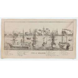
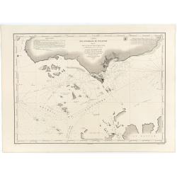
View of Singapore
Very rare view of Singapore from the Singapore River Basin. With a numbered key (1-19) underneath the illustration. In the center Government Hill with Governer's House (1...
Date: ca. 1850
Carte des Détroits Singapore, Durain..
An exceptionally rare nautical chart of Singapore and direct vicinity issued by Urban Dortet de Tessan, under the patronage of Louis Philippe I of France. When Singapore...
Date: Paris, 1848
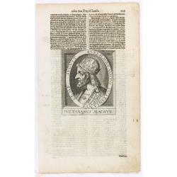
Caes. Flavius Anicius Iustinianus Semp. August.
The engraving depicts a half length oval portrait of "Caes. Flavius Anicius Iustinianus".Nicolaes de Clerck (de Klerc) was active as engraver and publisher in D...
Date: Amsterdam, Cloppenburch, 1621