Subscribe to be notified if similar examples become available.
Guiana sive Amazonum regio. |
||||||||||||||||||||
|
||||||||||||||||||||
|
|
||||||||||||||||||||
|
Selling price: $ Please login to see price!
Sold in 2026 Missed this item! Add your name to our mailing list and be the first to get notified about our newly added listings. . |
My Collection +
Add this or any of your favorite items in one place. If you want to save the items permanently, you have to sign in or create an account first. |
|||||||||||||||||||
Description
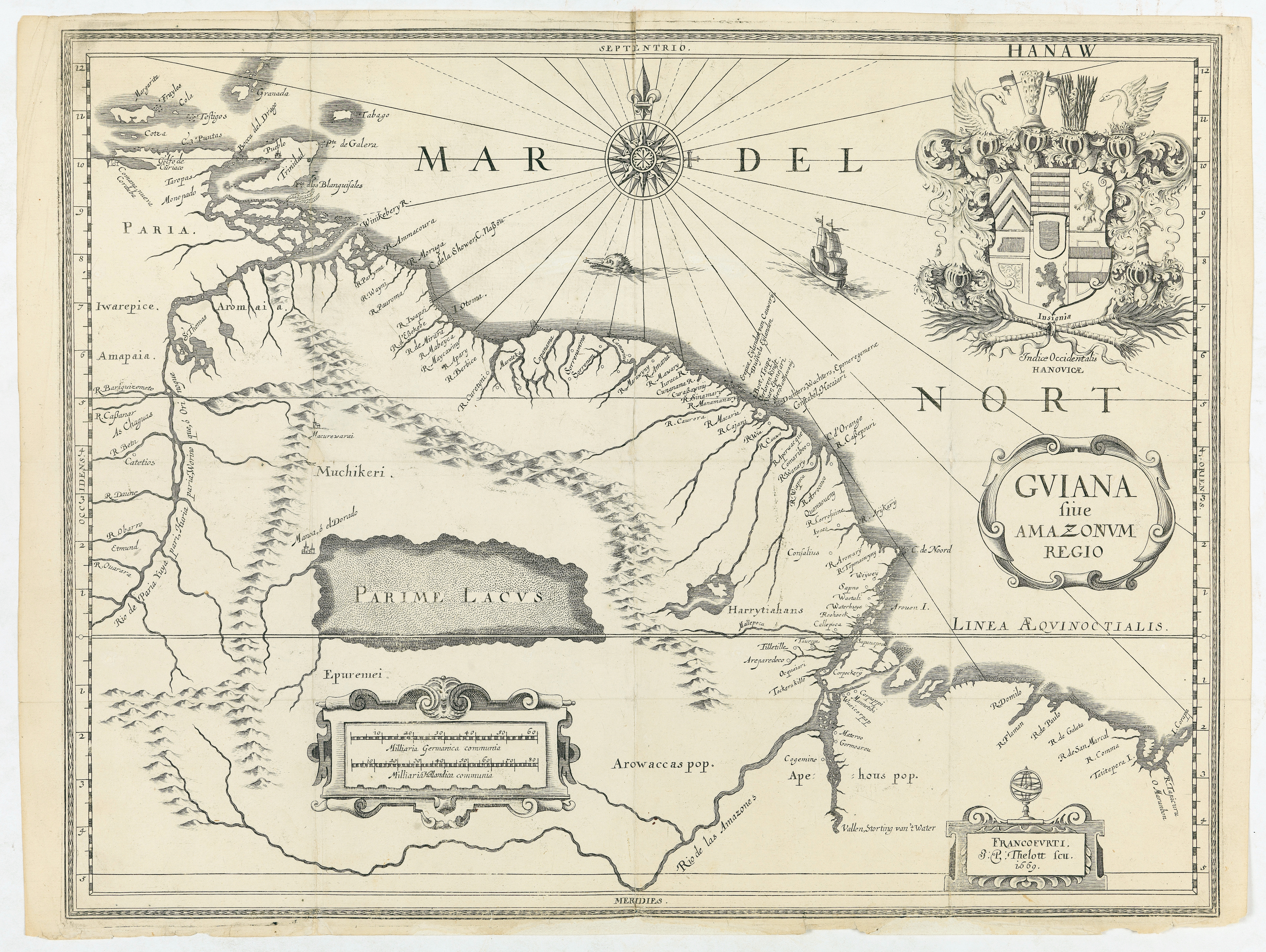
This very rare map shows northwest Latin America with Surinam and French Guiana and was engraved by Johann Philipp Thelott. The map comes from the work of Johann Joachim Becher entitled "Gründlicher Bericht von Beschaffenheit und Eigenschafft, Cultivirung und Bewohnung, Privilegien and Beneficien dess in America zwischen dem Rio Orinoque and Rio de las Amazones an der vesten Küst in der Landschafft Guiana gelegenen".
The map is dedicated to Count Friedrich-Casimir of Hanau-Lichtenberg, whose imposing coat of arms adorns the upper right corner. At the bottom of these coats of arms appears the words "Insignia Indiæ Occidentalis Hanovicæ" and the arms of the Hanauvian West Indies. Around 1669, Count Hanau-Lichtenberg intended to establish a colonial empire in the Guianas by seeking to be assigned a fief by the West Indies Company or Dutch West India Company, vast territories between the Orinoco and Amazon rivers, to found its own colony of the Hanauisch-Indian or the Hanauvian Indies. The project, probably inspired by Johann Joachim Becher, was disproportionate and never saw daylight due to a lack of funding.
The map covers the northwestern part of Latin America, from Venezuela to the Itapecuru River in northeastern Brazil. In the centerfeatures the mythical lake of Parime. Until the 19th century, cartographers reported in the unexplored space between the Orinoco and the Amazon this immense lake on the banks of which rises Manoa, also called El Dorado, a fabulous city with walls of gold. The city appears here under the name of Manoa. In French Guiana, we distinguish the island of Cayenne, today a peninsula, the Cayenne River, named R. Cajani, and the Kaw River named R. Cauwo. The Kourou River, near the town of the same name, is called R. Caurora. Off the coast of Venezuela, we can see the Margarita Islands, Grenada and Trinidad and Tobago. The Atlantic, called Mar del Nort, is decorated with a beautiful compass rose, a ship, and a sea monster. For his map, Becher took information from that of Janssonius, Hondius and Blaeu, while modifying it by replacing the main title with the coat of arms of the Count Hanau-Lichtenberg, and the two ships in the Atlantic by the title.
References : Tross, Thesaurus bibliothecalis, pars altera. Catalogue de bons et beaux livres imprimés et manuscrits en vente aux prix marqués chez M. Edwin Tross (Maison Silvestre), 1856, p. 3, 20 ("très rare") ; Librairie A. Franck, Bibliotheca Americana. Collection d'ouvrages inédits ou rares sur l'Amérique, Catalogue de livres, manuscrits et cartes relatifs à l'Amérique, 1864, p. 14, 185 ("curieux et rare") ; Phillips, Guiana and Venezuela Cartography, 1898, p. 703.
Reference: Venezuela Cartography, 1898, p. 703.
FAQ - Guarantee - Shipping
Buying in the BuyNow Gallery
This item is available for immediate purchase when a "Add to Cart" or "Inquire Now" button is shown.
Items are sold in the EU margin scheme
Payments are accepted in Euros or US Dollars.
Authenticity Guarantee
 We provide professional descriptions, condition report (based on 45 years experience in the map business)
Paulus Swaen warrants the authenticity of our items and a certificate of authenticity is provided for each acquired lot.
Condition and Coloring
We indicate the condition of each item and use our unnique HiBCoR grading system in which four key items determine a map's value: Historical Importance, Beauty, Condition/Coloring and Rarity.
Color Key
We offer many maps in their original black and white condition. We do not systematically color-up maps to make them more sellable to the general public or buyer.
Copper engraved or wood block maps are always hand colored. Maps were initially colored for aesthetic reasons and to improve readability. Nowadays, it is becoming a challenge to find maps in their original colors and are therefor more valuable.
We use the following color keys in our catalog:
Original colors; mean that the colors have been applied around the time the map was issued.
Original o/l colors; means the map has only the borders colored at the time of publication.
Colored; If the colors are applied recently or at the end of the 20th century.
Read more about coloring of maps [+]
Shipping fee
A flat shipping fee of $ 30 is added to each shipment by DHL within Europe and North America. This covers : International Priority shipping, Packing and Insurance (up to the invoice amount).
Shipments to Asia are $ 40 and rest of the world $50
We charge only one shipping fee when you have been successful on multiple items or when you want to combine gallery and auction purchases.
Read more about invoicing and shipping
FAQ
Please have a look for more information about buying in the BuyNow gallery
Many answers are likely to find in the general help section.
My Collection+
![]()
With My Collection+ you can collect all your favorite items in one place. It is free, and anyone can create his or her virtual collection.
Unless you are logged in, the item is only saved for this session. You have to be registed and logged-in if you want to save this item permanently to My Collection+.
Read More[+]
Register here, it is free and you do not need a credit card.
Add this item to
My Collection+
or click the following link to see My Collection+.
| Digital Image Download | |
|
Paulus Swaen maintains an archive of most of our high-resolution rare maps, prints, posters and medieval manuscript scans. We make them freely available for download and study. Read more about free image download |
Click the image for a free small image download. |
In accordance with the EU Consumer Rights Directive and habitually reside in the European Union you have the right to cancel the contract for the purchase of a lot, without giving any reason.
The cancellation period will expire 14 calendar days from the day after the date on which you or a third party (other than the carrier and indicated by you) acquires, physical possession of the lot. To exercise the right to cancel you must inform Paulus Swaen Inc, of your decision to cancel this contract by a clear statement (e.g. a letter sent by post, or e-mail.
To meet the cancellation deadline, it is sufficient for you to send your communication concerning your exercise of the right to cancel before the cancellation period has expired.
