Recently Listed Listings
![[Australia and New Zealand map with Ottoman script.]](/uploads/cache/44313-250x250.jpg)
[Australia and New Zealand map with Ottoman script.]
Post card size map in Ottoman script showing Australia and New Zealand prepared by Mehmet EŞREF in a small atlas : عمومولاياةىشهانيىحاوىكوچكا�...
Date: Istanbul, 1325 or 1909
![[United States map with Ottoman script.]](/uploads/cache/44314-250x250.jpg)
[United States map with Ottoman script.]
Postcard-size map in Ottoman script showing the United States, prepared by Mehmet EŞREF in a small atlas: عمومولاياةىشهانيىحاوىكوچكاطلاس [...
Date: Istanbul, 1325 or 1909
![[Persia, Afghanistan and Pakistan map with Ottoman script]](/uploads/cache/44316-250x250.jpg)
[Persia, Afghanistan and Pakistan map with Ottoman script]
Postcard size map in Ottoman script showing Persia, Afghanistan and Pakistan prepared by Mehmet EŞREF in a small atlas : عمومولاياةىشهانيىحاوىكو�...
Date: Istanbul, 1325 or 1909
![[Asia map with Ottoman script]](/uploads/cache/44317-250x250.jpg)
[Asia map with Ottoman script]
Postcard size map in Ottoman script showing Asia, prepared by Mehmet EŞREF in a small atlas : عمومولاياةىشهانيىحاوىكوچكاطلاس [Umum-i vilay...
Date: Istanbul, 1325 or 1909
![[Australia, New Zealand and Oceania map with Ottoman script]](/uploads/cache/44319-250x250.jpg)
[Australia, New Zealand and Oceania map with Ottoman script]
Postcard size map in Ottoman script showing Australia, New Zealand and Oceania prepared by Mehmet EŞREF in a small atlas : عمومولاياةىشهانيىحاوىك�...
Date: Istanbul, 1325 or 1909
![[World map in showing currents with Ottoman script]](/uploads/cache/44322-250x250.jpg)
[World map in showing currents with Ottoman script]
Post card size world map in Mercator projection showing the currents in Atlantic and Pacific Oceans in Ottoman script prepared by Mehmet EŞREF in a small atlas : عمو...
Date: Istanbul, 1325 or 1909
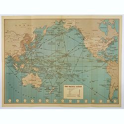
![[Set of two maps of the Pacific Ocean with transportation lines, with Ottoman script]](/uploads/cache/44327-250x250.jpg)
[Set of two maps of the Pacific Ocean with transportation lines, with Ottoman script]
Two post card size maps showing the Pacific Ocean with transportation lines. The maps are in Ottoman script prepared by Mehmet EŞREF in a small atlas : عمومولاي...
Date: Istanbul, Şirket-i Mürettibiye ve Karacoğlu Matbaas&#
![[Set of two maps showing world in Mercator projection, with Ottoman script]](/uploads/cache/44328-250x250.jpg)
[Set of two maps showing world in Mercator projection, with Ottoman script]
Two postcard size maps showing the entire world in Mercator projection. The maps are in Ottoman script prepared by Mehmet EŞREF in a small atlas : عمومولاياة�...
Date: Istanbul, 1325 or 1909
![[ North and South America with telegraph cables, with Ottoman script]](/uploads/cache/44330-250x250.jpg)
[ North and South America with telegraph cables, with Ottoman script]
Postcard size map showing North and South America with telegraph cables. The map is in Ottoman Arabic-script prepared by Mehmet EŞREF in a small atlas : عمومولا�...
Date: Istanbul, 1325 or 1909
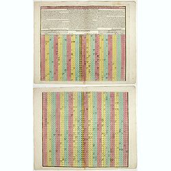
Tabula chronologica historiae Sinicae connexa cum cyclo qui vulgo Kia Tse dictur.
A set of two sheets of colored copper engravings. First published in 1729 in Rome in three sheets. Timeline of China's history with a chronological overview of the dynast...
Date: Augsburg, 1746
![ИНДIИ [Map of India in Cyrillic].](/uploads/cache/44340-250x250.jpg)
ИНДIИ [Map of India in Cyrillic].
A map of India. This Cyrillic version of the map appeared in one of the first world atlases published in Russia, "Novy Atlas, ili sobranie kart ..." which trans...
Date: Paris / St.Petersburg, ca. 1790
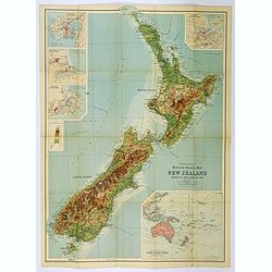
Bartholomew's Touring Map of New Zealand.
A full color map. 'Reduced Survey Map of New Zealand, colored to Show Height of Land'. With insets of Auckland Harbour, Wellington and Port, Christchurch and Port Lyttelt...
Date: Edinburgh, 1935
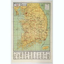
The Road Map of Southern Korea.
Offset printing. A large scale, comprehensive road map of South Korea, with a symbol legend and an inset map of 'The Republic of Korea', and inset of the island of Jeju D...
Date: Seoul, ca 1960
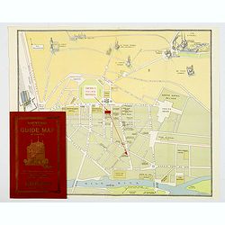
Souvenir Guide Map of Cairo.
A lovely small colored plan of central Cairo, published by Groppi in Cairo. Plan is housed within the original red and gold printed paper covers, with advertisements for ...
Date: Cairo, 1920-1950
![Air France [poster].](/uploads/cache/44299-250x250.jpg)
Air France [poster].
A superb double-sided Air France folding poster, featuring bold colored graphics. Published as a serious piece of marketing put out by the airline showing off their state...
Date: Paris, 1955
Hammond's War Map.
Drawn and published in early 1942 by C. S. Hammond & Co. in direct response to the bombing of Pearl Harbour, this is one of the most detailed USA maps of the Pacific ...
Date: New York, 1943

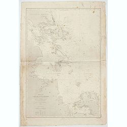
Carte de L'Archipel de La Recherche a la partie Occidentale de la Terre de Nuyts. . .
A large and detailed chart of the southern West Australian coast centered on the region of Esperance and the surrounding islands.Terre de Nuyts is the name that was forme...
Date: Paris 1807

Kaart van Het Noordelijk Gedeelte Van Het Eiland Borneo.
A very detailed map of Northern Borneo including Brunei, taken from the "Atlas der Nederlandsche bezittingen in Oost-Indië", which was published by Departement...
Date: The Hague, 1883-1885
![[Afghanistan].](/uploads/cache/44611-250x250.jpg)
[Afghanistan].
A scarce Russian relief map (in Russian) of Afghanistan published in Moscow during the Soviet occupation of the country during the early 1980s. Complete with a separate b...
Date: Moscow, 1982

The hanging of the head of police Jean Grauwels in Brussels, 11 february 1569.
Print relating to Brussels during the first decades of the eighty year war between Spain and the Low Countries: (plate 18). This plate shows the hanging of the head of po...
Date: Cologne, ca. 1590

Présentation solennelle d'une seringue d'honneur au 9e lancelot pour le Ier de l'an 1832.
Uncommon plate showing a solemn presentation of a syringe of honor at the 9th Lancelot for the 1st of the year 1832]. Hand colored lithographed plate by Delaporte after C...
Date: Paris, c. 1832

Carta particolare che comincia con il c.apo Aldea è Finisce con il capo Degortam. . .
Dudley’s magnificent chart shows the south west coast of Africa with the Tropic of Capricorn, located at about 23.5 degrees south. Without the privilege, but with "...
Date: Florence, 1645
![[Title in Ottoman Turkish: SOUTHERN AFRICA].](/uploads/cache/44732-250x250.jpg)
[Title in Ottoman Turkish: SOUTHERN AFRICA].
A fine Ottoman map of Southern Africa from Ali Şeref Paşa’s rare "Yeñi coġrafya aṭlası", published by the press of Matbaa-i Amire, the successor of İb...
Date: Beyazit, Istanbul: Matbaa-i Amire 1311 or 1895
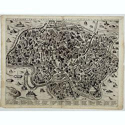
Antiquae urbis perfecta et Nova delineatio. [ Ancient Rome)
First state before imprint of Jacobus de Rubeis. A rare view of Ancient Rome from the Lafreri-School in the style of Ambrogio Brambilla's view of about 1575. A unique opp...
Date: Rome, ca. 1600

Peregrinatie Jesu Christu Een ordentliche beschrijvinge des Heijligen landts....
Very rare separately map of the Holy Land engraved by Joannes van Doetecum Jr. Oriented to the east. The shoreline runs from "Antaradus" in Syria to "Rhino...
Date: Amsterdam, ca. 1595
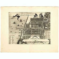
Plan de la Ville et du Chateau de Batavia en l'Isle de Iava / Ware affbeeldinge wegens het Casteel ende Stadt Batavia gelegen opt groot Eylant Java.
Detailed East oriented plan of Jakarta former Batavia on Java / Indonesia. With bird eye view from sea side, various ships and a lion. Two inset keys with detailed descri...
Date: Leiden, 1730
![[Ritter Sundial Map of the World]](/uploads/cache/60731-250x250.jpg)
[Ritter Sundial Map of the World]
This highly unusual map projects the world from the north pole as though it were the table of a sundial, with the land masses drawn to scale in proportion to their distan...
Date: Nuremberg, 1640
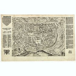
Jerusalem die vernaamste van alle steden... / Jerusalem die Heijlighe Stadt van God. . .
Very rare separately published plan of Jerusalem, engraved by Joannes van Doetecum Jr., Variant to Poortman, Kaarten in Bijbels, map 64. In the lower part, the copper pla...
Date: Amsterdam, 1598-1630

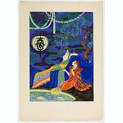
Art Deco gouache with Japanese scene.
Lovely art-deco gouache by Lucien Baubaut of an elaborately robed Japanese woman. The colors are simply stunning jewel-toned emerald, violet, deep purple, saffron and tan...
Date: Paris, ca. 1930

An elegant woman seducing a man.
Lovely art deco pochoir by Russo-Italo artist Endré (Andrew de Passano) 1905-93. Exotic and gorgeously colored Art Deco print with elaborately robed people. The colors ...
Date: Paris, ca. 1930
Conversing by the Scented Pool.
Lovely art deco pochoir by Russo-Italo artist Endré (Andrew de Passano) 1905-93. Exotic and gorgeously colored Art Deco print of an elaborately robed Chinese couple, cle...
Date: Paris, ca. 1930
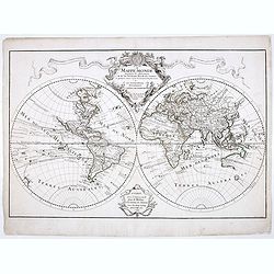
Mappe-Monde dressée sur les observations de M.rs. De L'Academie Royale des Sciences ..
Scarce and early state of the world map published c. 1707, by Delisles with the imprint "Chez l’Auteur sur le Quai de l’Horloge a la Couronne de Diamans, 1700&qu...
Date: Paris, 1707
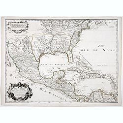
Carte du Mexique et de la Floride.
Third state, with "Quai de l'Horloge" imprint. Renard’s imprint has been erased”. It was the first printed map to portray accurately the course and mouth of...
Date: Paris, 1703
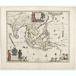
India quae Orientalis dicitur, et insulae adiacentes.
Extending from India to Japan and showing parts of Australia. It is indeed one of the first printed maps to show identifiable parts of Australia. It was not revised until...
Date: Amsterdam, 1644

Vue et perspective de la ville de Marseille et ses environs, prise du côté de la belle vue de la plaine St. Michel. Dediée à S. A. S. Mgr. le duc de Penthievre Grand Amiral de France. Par son très humble et très obéissant Serviteur Aulagnier.
Scarce large and spectacular panorama of the city and harbour of Marseille published in Paris in the middle of the 18th century. Engraved by Pierre Jacques Duret under th...
Date: Paris, 1751
![[View of Gulf of Trieste].](/uploads/cache/45191-250x250.jpg)
[View of Gulf of Trieste].
Very rare view of Gulf of Trieste published in the first edition of "Viaggio da Venetia, a Costantinopoli. Per Mare, e per Terra, & infieme quello di Terra Santa...
Date: Venice, Giacomo Franco, 1598
Carte Reduite, des Cotes De L'Acadie, de L'Isle Royale, et de la Partie Meridionale de L'Isle de Terre Neuve.
An important chart of Nova Scotia, southern Newfoundland and the Grand Banks, prepared after Chabert's voyage to Canada to update the French charts of Eastern Canada. It ...
Date: Paris, 1753
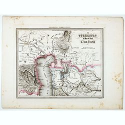
Il Turkestan il Mar d'Aral ed il Mar Caspio.
Uncommon map of Turkestan with the Northern part of the Caspian Sea, with part of present-day Uzbekistan in the lower right corner. in the prepared by Francesco Costant...
Date: Genova, Paolo Rivara fu Giacomo, 1858
![[World and 4 continents] Carte Geographique Astronomique Chronologique et Historique du Monde.](/uploads/cache/63024-250x250.jpg)
[World and 4 continents] Carte Geographique Astronomique Chronologique et Historique du Monde.
French wall map of the world in 4 sheets published by Crépy "à l'entrée du Cloistre de St. Benoist du côté des maturins". A decorative wall map of the worl...
Date: Paris, 1720-1735
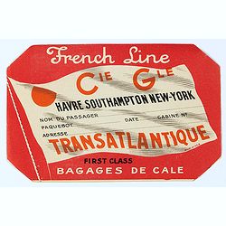
French Line First Class Bagages de Cale.
French Line First Class Bagages de Cale sticker for the journey Havre- Southhamptons New-York. It used to be stuck on luggage. The Compagnie Générale Transatlantique is...
Date: Paris, ca. 1950
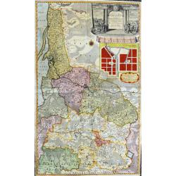
Potentissimo Borussorum Regi Friderico Wilhelmo...
Large and sought-after 2-sheet map of an area of Lithuania and Eastern Prussia (Russian province of Kaliningrad) stretching from Klaipeda (Memel) in the north to Goldap i...
Date: Nuremberg, 1735
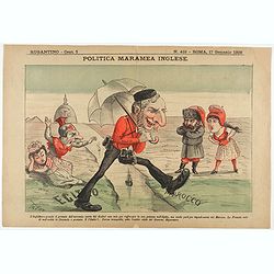
Politica Maramea Inglese - Rugantino - n°419 - Roma 17 Gennaio 1892.
Satirical print relating to the British Conquest of Egypt (1882), also known as Anglo–Egyptian War, between Egyptian and Sudanese forces under Ahmed ‘Urabi and the Un...
Date: Rome, January 17, 1892
Perspective print by Vredeman de Vries. 43.
Engraving from Perspective, c'est a dire, le tresrenomme art du poinct oculaire d'une veue dedans ou travers regardante, estant sur une muraille unie, sur un tableau, ou ...
Date: The Hague, 1604 - 1605
![Le Roy de Navarra venant à Paris recheut le coup de cousteau au visaige par ung Pierre Chastel, lequel par quatre chevaulx fut tiré en pièces, faict le 27 de Decemb[re] l'an 1594.](/uploads/cache/38548-250x250.jpg)
Le Roy de Navarra venant à Paris recheut le coup de cousteau au visaige par ung Pierre Chastel, lequel par quatre chevaulx fut tiré en pièces, faict le 27 de Decemb[re] l'an 1594.
Engraved news-sheet with text in German and French. Pictorial reportage on the failed assassination attempt on King Henri IV of France by Jean Châtel (here identified as...
Date: Cologne, ca. 1600
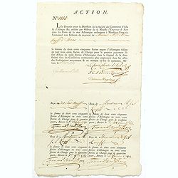
ACTION N° 1155. Société du Commerce d'Asie & d'Afrique.
Share of 1 000 Florins d'Allemagne (1 000 Guilder) of the "Triester Handelsgesellschaft" (Société du Commerce d'Asie & d'Afrique) signed by duke Charles d...
Date: Triest / Antwerpen, 1 October 1781
Afbeeldinghe vande: arck. met. Noe. en. het. vee. daer. bij.
Engraving by Jan van Londerseel (Antwerpen 1570 - Rotterdam 1624) and published by Claes Jansz. Visscher. Large engraving showing the ark of Noah. Noah, his three sons, t...
Date: Amsterdam, ca. 1650

Mer de Chine - Detroit De Singapour Partie Comprise Entre Singaour et Le Dett. De Malacca d'apres les travaux du Commr. J.W. Reed de la Marine Royale d'Angleterr...
Mer de Chine - Detroit De Singapour Partie Comprise Entre Singaour et Le Dett. De Malacca d'apres les travaux du Commr. J.W. Reed de la Marine Royale d'Angleterr, execute...
Date: London, 1871
Mer de Chine - Carte des Iles et Détroits entre Singapoure et le Détroit de Banca. Dréssée d'après le stravaux Anglais et Hollandais plus récents, par Mr. L. Manen . . . 1866
A nautical chart of Singapore and neighboring islands. The first edition of the chart was published in 1866 from French and English sources, this is the corrected version...
Date: London, 1866-1871
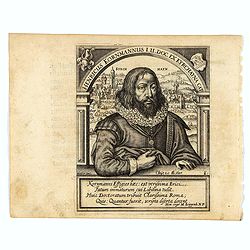
Henricus Kornmannus I.U. Doc. ex Kyrchayna cat.
Very skillfully engraved half-length portrait of Heinrich Kornmann, in frontal view, underneath an arch and with a view of Kirchhain in background and coats-of-arms in up...
Date: Frankfurt, 1630
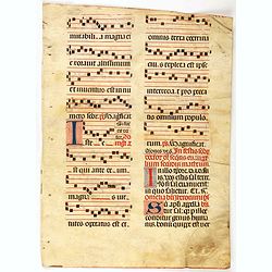
Leaf on vellum from an antiphonary.
A very fine antiphonary leaf, written in Latin , probably Rome. RECTO: The staves are in red and the notes in black.VERSO: Tw wonderful initial ,A and O, decorated with p...
Date: Italy, 1480
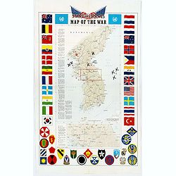
Pacific Stars and Strips Map of the War.
A detailed map of the Korean War. Several silhouetted flying military aircraft are shown in formation. The map shows the Korean Peninsula from its northern border with Ru...
Date: America, 1953
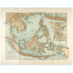
Hinterindien und Malayischer Archipel.
Map of South East Asia with four insets. Shows settlements, roads, railways, telegraph cables, etc. A color key to Dutch, French, British, and Portuguese occupations. Inc...
Date: Leipzig, 1905
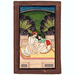
Indian painting on paper.
Fine miniature, presenting a couple in love making position, set on a balcony with in a landscape in the background. The miniature has been painted in India in late 19th ...
Date: India, ca. 1900
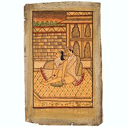
Indian painting on paper.
Fine miniature, presenting a couple in love making position, set in an interior. The miniature has been painted in India in late 19th - early 20th century. The miniature ...
Date: India, ca. 1900
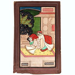
Indian erotic painting on paper.
Fine miniature, presenting a couple in a love-making position, set on a balcony within a landscape in the background. The miniature was painted in India in the late 19th ...
Date: India, ca. 1900
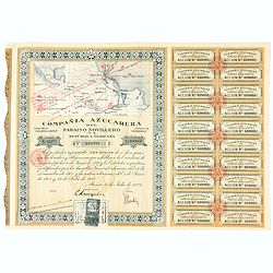
Accion de 10 pesos. No. 110,931 (Share certificate)
Beautifully engraved certificate from the "Compania Azucarera de Paraiso Novillero S.A. Republica Mexicana", share certificate No.110,931 for one share, in a $ ...
Date: Paris, 1924
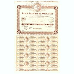
Share of 100 Francs. No. 003841 (Share certificate)
Beautifully engraved certificate from the "Société Financière de Madagascar", share certificate No. 003841 for one hundred shares, in a 5,000000 francs loan....
Date: Paris, 1929

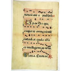
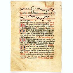
Leaf on vellum from a antiphonary.
A leaf from a Medieval Antiphonal or Choir Missal for Spanish use, in Latin on an extremely heavy vellum. Justification: 360x246mm. Text is in Spanish rounded gothic hand...
Date: Sevilla, ca.1520
Leaf on vellum from a antiphonary.
A leaf from a Medieval Antiphonal or Choir Missal for Spanish use, in Latin on extremely heavy vellum. Justification: 360x246mm. Text is in Spanish rounded gothic hand (R...
Date: Sevilla, ca.1520
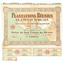
Accion de 10 pesos. No. 110,930 (Share certificate)
Beautifully engraved certificate from the "Plantations Réunies de l'Ouest africain SA", share certificate No.232.781 for one hundred shares, in a 30,000,000 lo...
Date: Paris, Abidjan, 1930
Leaf on vellum from a antiphonary.
A leaf from a Medieval Antiphonal or Choir Missal for Spanish use, in Latin on extremely heavy vellum. Justification: 360x246mm. Text is in Spanish rounded Gothic hand (R...
Date: Sevilla, ca.1520
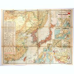
Übersichtskarte von Ost-Asien im Maßstabe 1: 5.000.000 mit 14 Beikarten in großen Maßstäben . . .
A large, uncommon map of East Asia prepared by Karl Peucker, and published by Ataria & Co. Striking and heavily annotated with information on China, Korea, Japan, and...
Date: Vienna, Artaria, 1904
![[A lady playing a piano.]](/uploads/cache/46519-250x250.jpg)
[A lady playing a piano.]
Lovely art deco etching with hand coloring showing a lady playing piano. The artwork is signed in black pencil, but not identifiable.
Date: Paris, ca. 1930
![[A beautifully dressed woman in a garden.]](/uploads/cache/46520-250x250.jpg)
[A beautifully dressed woman in a garden.]
Lovely art deco pochoir showing a beautifully dressed woman in a garden.
Date: Paris, ca. 1930
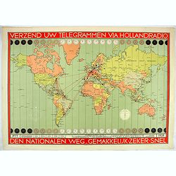
Verzend uw telegrammen via Holland Radio Den Nationalen weg. Gemakkelijk -Zeker - Snel.
Poster showing a world map in Mercator projection. In top and bottom clocks showing the time zones. Red lines connecting The Netherlands with different major hubs in Amer...
Date: The Netherlands, 1939
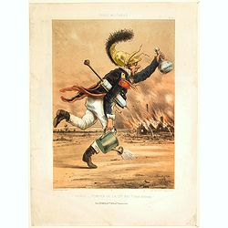
France - Pompier de la Garde Nationale, Tenue d'Incendie.
'Military Types'. A humorous lithograph of a French firefighter rushing with various containers (Including a clyster) to attempt to put out a fire in a building.
Date: Paris, ca 1870
![Aux grands maux les grands remedes. [To great ills great remedies]](/uploads/cache/46558-250x250.jpg)
Aux grands maux les grands remedes. [To great ills great remedies]
A humorous French lithograph showing a village scene where a small infant is held face down on his/her mother's lap, with clothing pulled up to reveal its bottom. An enor...
Date: Paris, ca 1850
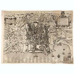
Palermo.
Rare bird's-eye view of Palermo, the plan showing the city and harbor within the city walls, with the surrounding countryside, title and dedicatory verse set in elaborate...
Date: Seina, ca. 1600
![[Untitled cartoon in pencil.]](/uploads/cache/46791-250x250.jpg)
[Untitled cartoon in pencil.]
A pharmacy cartoon in French, drawn probably in the first half of the last century. It depicts a pharmacist giving some advice to another, seen crushing a powder with a p...
Date: French, ca. 1950
Les Jouissance du Juste Milieu.
[The Joys of the Happy Medium.] A waiter is about to serve a customer with a clyster pump and water jug. It looks as though the man has a 'menu' in one hand. On another t...
Date: Paris, ca 1820
![[No title.] Sixteen small engravings.](/uploads/cache/46799-250x250.jpg)
[No title.] Sixteen small engravings.
A nice set of sixteen French professions, or trades, or stage characters. The print is faint on some titles. Some of the characters are a soldier, a doctor, a nun, a lawy...
Date: Paris, ca. 1780
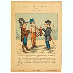
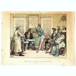
La Galerie Comique.
A lithograph by Gustave Frison, showing three town inhabitants discussing a clyster or syringe found in a public place. They think it may be a musical instrument, without...
Date: Paris, ca 1870
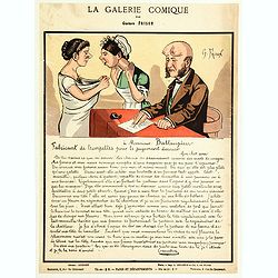
La Galerie Comique.
Lithograph by Gustave Frison showing a man writing a letter "to Monsieur Battaupieu, Manufacturer of trumpets for the Last Judgment…." (which is written in fu...
Date: Paris, ca 1870

Malte Vue prise de la Mer. - Malta Vista lomada del mar.
Very decorative view of the Grand Harbour of Malta by Louis Lebreton, published in "Ports de Mer d’Europe" in 1859 by L. Turgis in Paris.This lithography show...
Date: Paris, Turgis, 1859
![[Pictorial map of Georgia (Caucasus)].](/uploads/cache/47135-250x250.jpg)
[Pictorial map of Georgia (Caucasus)].
A scarce pictorial map of a region in Georgia in the Caucasus. Map is entirely in Russian, complete with legend at base of map, with small thumbnail pictures and symbols ...
Date: Moscow, 1963
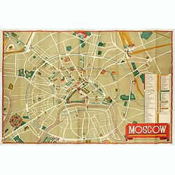
Moscow.
Fantastic pictorial map of Moscow designed to draw tourists to the new Soviet Union.The cultural vitality of Moscow in the early years of the Soviet Union is the focal po...
Date: Moscow, c. 1938
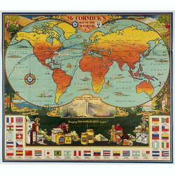
McCormick's Map of the World.
Colorful promotional map of the 20th century spice trade.What better way to showcase the global composition of a multi-national company than with a world map? This lovely...
Date: United-States, 1931
![[Stop race of nuclear weapons.]](/uploads/cache/47059-250x250.jpg)
[Stop race of nuclear weapons.]
Uncommon Soviet propaganda poster.Read more about the Soviet propaganda poster. [+]
Date: Moscow, 1986
![Mapa geral do Brasil / organizado pelos J. Carneiro da Silva e Pedro Voss. [Together with] Micro geografia do Brasil. [Together with] Pequeno Mapa do Brasil.](/uploads/cache/45466-250x250.jpg)
Mapa geral do Brasil / organizado pelos J. Carneiro da Silva e Pedro Voss. [Together with] Micro geografia do Brasil. [Together with] Pequeno Mapa do Brasil.
Large folding national map published by "Comp. Melhoramentos de São Paulo Industrias de Papel". Nova edicao revista 1946. Figures for all states. "Futuro ...
Date: São Paulo, 1946
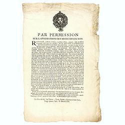
Par permission sur l'aprobation des médecins du roi...la véritable Boule de Mars...
Printed broadsheet promoting the "Boule de Mars" (March Ball) produced and sold by Renault in Nancy and Paris. Ornated with the royal coat of arms of France. Pr...
Date: Paris, ca.. 1780