Recently Listed Listings
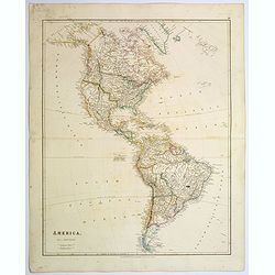
America.
A beautiful, large-scale map of the Americas. Alaska is named as 'Russian America', Texas is still a part of Mexico, yet to become a republic (1836), before finally becom...
Date: London, 1839
Selling price: ????
Please login to see price!
Sold in 2025

Fossa Sanctae Mariae.
Detailed map of part of the country between rivers Rhine and Meuse showing a canal to be dug between 1626 and 1628 between Rheinberg in Germany and Venlo. A deficiency of...
Date: Amsterdam, 1645
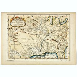
Carte de la Floride, de la Louisiane, et Pays Voisins. . .
Jacques Nicolaas Bellin (1703-1772) was one of the most important and proficient French cartographers of the mid-eighteenth century. He was appointed the first Ingenieur ...
Date: Paris, 1757
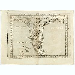
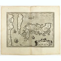
Calecut Nuova Tavola.
Early map of India, extending from west of the Gujarat peninsula eastward to Bengal and south as far as northern Ceylon (“Ceilam”). Girolamo Ruscelli first published ...
Date: Venice, 1564
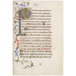
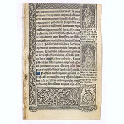
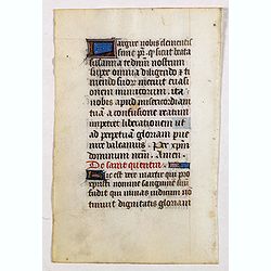
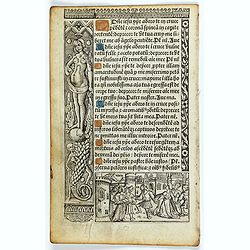
Leaf on vellum from a Missal.
A very fine Missal leaf, written in Latin. RECTO: A wonderful initial P decorated with pen work in red, purple and blue. The initial is 6x6cm. VERSO: 18 lines written in ...
Date: France, c. 1410
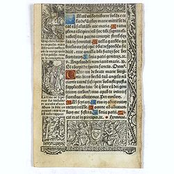
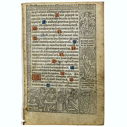
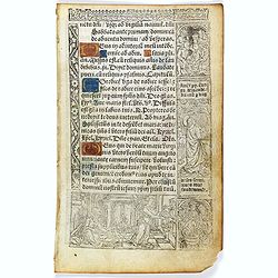
Leaf on vellum from a printed Book of Hours.
21 lines of printed text, surrounded by Renaissance borders decorated with flowers, vases and persons in Medieval dress.From the press of the leading Parisian publisher a...
Date: Paris, Germain Hardouyn, c. 1520-1540
Leaf on vellum from a printed Book of Hours.
21 lines of printed text, surrounded by Renaissance borders decorated with flowers, vases and religious scenes.From the press of the leading Parisian publisher and illumi...
Date: Paris, Germain Hardouyn, c.1520-1540
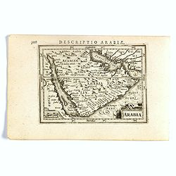
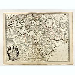
Arabia.
FIRST IMPRINT FROM THE NEWLY ENGRAVED PLATES IN 1616. - A rare miniature map of the Arabian Peninsular. Title cartouche on the lower left corner.First published in 1598 i...
Date: Amsterdam, J. Hondius, 1616
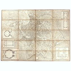
Pianta topografica di Roma moderna estratta dalla grande del Nolli an 1829
Town plan of Rome based on map by Giovanni Battista Nolli, ( fl. 1692-1756). Engraved by Pietro Ruga. With a key (I - XIV), scale and text "Nuova pianta di Roma mode...
Date: Rome, 1829

Carte du Golfe de Bengale, mer des Indes et rivieres du Gange . . .
Detailed scare map of the Southern part of India with Ceylon. Good detail along the coasts of Malabar, Coromandel, the Maldives islands and the Kingdoms of Visipour, Golc...
Date: Leiden, 1719

The Greyhound Map of This Amazing America. . .
A large colored lithograph map of the USA, published by the Greyhound Corporation during the Second World War. The map demonstrates where all the Greyhound bus routes int...
Date: United States, 1941

Deutschlands Postkarte begraenzt von Oesterreich, Preussen, Frankreich, Holland, Italien und der Schweiz. . .
A detailed and crucial post-road map prepared by Ignaz Heymann. The map shows the Low Countries, Germany, Poland, Austria, Hungary, etc.Borders in original outline colo...
Date: Triest, 1800
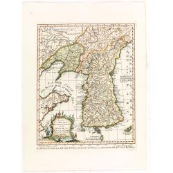
Carte de la province de Quan-tong, ou Lyau-tong et du Royaume de Kau-li ou Corée. . . / Kaart van t' Landschap Quan-Tong . . .
Uncommon issue of this fine map of Korea. The map is of interest for the use of East Sea, the sea between Korea and Japan, here called "Mer de Corée.Decorative titl...
Date: Paris, 1749-1773

The Harbour of Casco Bay and Islands Adjacent Bt Capt. Cyprian Southicke.
The earliest printed chart of Casco Bay, an inlet of the Gulf of Maine on the southern coast of Maine, New England. First issued in 1720 by Mount and Page, it remained in...
Date: Dublin, 1767
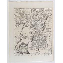
A map of Quan-Tong or Lyau-Tong province, and the kingdom of Kau-Li or Korea . . .
Detailed map of Korea, Liaodong, and the tip of Shandong Province prepared by Thomas Kitchin for Thomas Salmon's Universal Traveller, based on D'Anville's landmark map of...
Date: London, 1747
Leaf on vellum from a manuscript Book of Hours.
Leaf from a mid 15 th. century manuscript Book of Hours. Written on vellum in neat Gothic book hand.VERSO: 17 lines of text, with 2-line capital in red and blue, heighten...
Date: France ca.1470
Leaf on vellum from a manuscript Book of Hours.
Leaf from a mid 15 th. century manuscript Book of Hours. Written on vellum in neat Gothic book hand.RECTO: 17 lines of text, with 2-line capital in red and blue, heighten...
Date: France ca.1470
Leaf on vellum from a manuscript Book of Hours.
Leaf from a mid 15 th. century manuscript Book of Hours. Written on vellum in neat Gothic book hand.VERSO: 17 lines of text, with 2-line capital in red and blue, heighten...
Date: France ca.1470
Leaf on vellum from a printed Book of Hours In Latin and French.
24 lines of printed text, surrounded by renaissance borders decorated with flowers, vases and figures. Gothic type, text in Latin, numerous one and two-line initials in g...
Date: Paris, Germain Hardouyn, c. 1520-1540

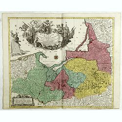
Gelriae, Cliviae, Finitimorumque Locorum Verissima..
East to the top. Fine map of Geldria and Limburg, prepared by Christian s'Grooten. Very fine title cartouche lower right with painter's utensils around the cartouche. ...
Date: Antwerp, 1598

Hollandiae Antiquorum Catthorum..
This map shows Holland in great detail, including small towns, walled cities, rivers and lakes (many of which were reclaimed in the 17th century, and no longer exist). A ...
Date: Antwerp, 1598
IAPONIAE INSULAE DESCRIPTIO.Ludoico Teisera auctore.
The map was based upon the manuscript draft supplied to Ortelius in about 1592 by the famous official Portuguese chart maker, Luis Teixeira , who was the cartographer t...
Date: Antwerp, 1598

Silesiae typus..
Fine and early map of Silesia after Martin Helwig (1516-1574) and used by A.Ortelius in his atlas 'Theatrum Orbis Terrarum [Atlas of the Whole World].Only included in the...
Date: Antwerp, 1598
Accuratissima totius Asiae tabula..
The map includes a detailed depiction of South East Asia and the Far East. The northern tip of Australia (Hollandia Nova) is shown as are the important discoveries made t...
Date: Amsterdam, 1680
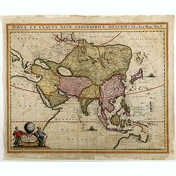
Asiae Nova Apud Hudo Allardt. / Nova et exacta Asiae geograpicha descriptio.
Rare map of Asia, with relief shown pictorially. Shows Great wall of China and the mythical island of Yedso north of Japan. Title at head of map: Nova et exacta Asiae geo...
Date: Amsterdam, 1660-1665
Perspective print by Vredeman de Vries. 40.
Engraving from Perspective, c'est a dire, le tresrenomme art du poinct oculaire d'une veue dedans ou travers regardante, estant sur une muraille unie, sur un tableau, ou ...
Date: The Hague, 1604 - 1605
![[Title in Russian; translated to : Who the death bears, that's himself in the end I'm sure I'll stretch my legs. (Google translation) ]](/uploads/cache/41506-250x250.jpg)
[Title in Russian; translated to : Who the death bears, that's himself in the end I'm sure I'll stretch my legs. (Google translation) ]
Propaganda mini poster published in Russia during The Cold War (1979–1985). The time refers to the phase of a deterioration in relations between the Soviet Union and th...
Date: Russia, 1982
![[Title in Russian; translated to : Believe in the power of a nuclear trucheon - It's up to you to celebrate a wake. ]](/uploads/cache/41508-250x250.jpg)
[Title in Russian; translated to : Believe in the power of a nuclear trucheon - It's up to you to celebrate a wake. ]
Propaganda mini poster published in Russia during The Cold War (1979–1985). The time refers to the phase of a deterioration in relations between the Soviet Union and th...
Date: Russia, 1982
![[Europe depicted as a Queen]](/uploads/cache/41499-250x250.jpg)
[Europe depicted as a Queen]
Among the most striking of early cartographic curiosities is Europe regina or Queen of the world first published by Johannes Bucius' and populized by Sebastian Münster.....
Date: France, ca. 1860
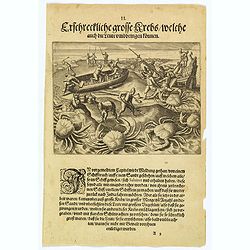
The Dutch are attacked by giant crabs.
During their return voyage, the Portuguese were wrecked on a sandbank (the Seychelles?) From the debris they began building a smaller ship in which they hoped to return t...
Date: Frankfurt, 1598
![[Tableau Général de l'Empire Ottoman]. 11 plates with the panoramic view of Mecca.](/uploads/cache/41513-250x250.jpg)
[Tableau Général de l'Empire Ottoman]. 11 plates with the panoramic view of Mecca.
A collection of 11 engraved plates (3 folding) from "Tableau Général de l'Empire Ottoman", Paris, Imprimerie de Monsieur, 1790, comprising the famous panorami...
Date: Paris, 1790
Le Isole del Giappone e la Corea delineate sulle ultima osservazioni.
First edition on laid paper. Cassini’s splendid early map of Japan and Korea, with a large decorative title cartouche. The map has a very unusual, almost triangular, re...
Date: Rome, 1797
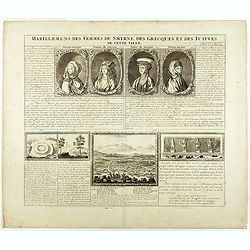
Habillement des femmes de Smyrnes, des Grecques et des Juifs de cette ville.
Four portraits of Smirne women in typical dress, each with a descriptive engraved text. From Chatelain's monumental 7 volume "Atlas Historique".Henri Abraham Ch...
Date: Amsterdam, 1720
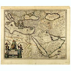
Turcicum Imperium.
A very handsome map featuring a particularly fine cartouche that depicts the Turkish Sultan on his throne, accompanied by allegorical figures on either side, brandishing ...
Date: Amsterdam, 1650
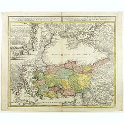
Carte de l'Asie Minevre ou de la Natolie et du Pont Euxin...
A map centered on the Black Sea and the geographical regions surrounding it. The map shows Asia Minor, Crete, Cyprus, northern Syria, Iraq, Georgia, Crimea, Bulgaria, Rom...
Date: Nuremberg, 1743
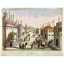
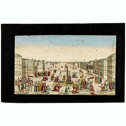
Prospectus, quem Solimanni et Mohameti. . . - Vue aupres de la Mosquee du Sultan Soliman, et de Mohamet . . .
Imaginary view inside Istanbul showing Sultan Soliman in his carriage , a so-called optical print.
Date: Augsburg 1750
Imaginary view of a square with Muslims festival.
Imaginary view of a square with Muslims festival. A so called optical print.
Date: Paris, ca. 1750
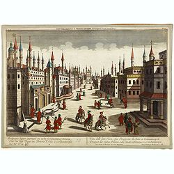
Prospectus septem turrium in urbe Constantinopolitana / Vüe des sept Tours ou Prisons d'etat à Constantinople. . .
Imaginary view inside Istanbul showing the State prison, the seven towers to Constantinople, a so-called optical print.
Date: Augsburg 1750
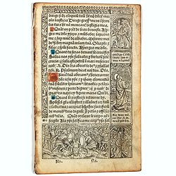
Leaf on vellum from a printed Book of Hours.
21 lines of printed text, surrounded by renaissance borders decorated with flowers, vases, religious scenes and a figure symbolizing the Danse Macabre consists of the dea...
Date: Paris, Germain Hardouyn, c.1520-1540
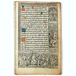
Leaf on vellum from a printed Book of Hours.
21 lines of printed text, surrounded by renaissance borders decorated with flowers, vases and religious scenes.From the press of the leading Parisian publisher and illumi...
Date: Paris, Germain Hardouyn, c.1520-1540
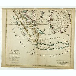
Le Royaume de Siam avec les Royaumes. . .
Influential map of the Malay peninsula, Sumatra, Java and Borneo, centered on Singapore. Mortier incorporated information provided by the French Jesuits and charts the ro...
Date: Amsterdam, 1700
![Tabula Asiae III [Black & Caspian Sea Region]](/uploads/cache/41831-250x250.jpg)
Tabula Asiae III [Black & Caspian Sea Region]
Attractive woodblock Ptolemaic map, depicting Armenia and in the Right part of the Caspian Sea with Noes Arch, believed to have come to rest in a mountain in Armenia acco...
Date: Basel, Heinrich Petri, 1545
Carte de la Turquie de l'Arabie et de la Perse.
Very rare state with the address : Chez l’Auteur, Rue des Canettes prez St. Sulpice. Avec Privilège, 1701". This early state with "rue des Canettes" imp...
Date: Paris, 1701
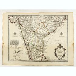
Carte des Cotes de Malabar et de Coromandel..
Detailed and attractive map of India and the northern tip of Sri Lanka. With decorative title cartouche and two compass roses.Rare edition with address : A Paris chez l�...
Date: Paris, 1723
L'Amerique Meridionale Dressée sur les Observations de Mrs de l'Academie Royale des Sciences . . .
Rare state of " L’Amerique Meridionale. Chez l’Auteur sur le Quai de l’Horloge a la Courone de Diamans avec Privilege du Roy pour 20 ans, 1700".Fine map o...
Date: Paris, 1700
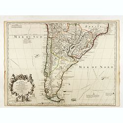
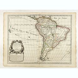
Carte du Paraguay du Chili.
A finely engraved, detailed map of the southern half of South America. Prepared by de l'Isle with the imprint "Chez l’Auteur sur le Quai de l’Horloge avec Privil...
Date: Paris, L. Renard, 1703
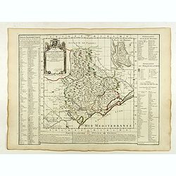
Carte du Diocese de Beziers . . .
Fine map of the diocese of Béziers with the address : A Paris Chez l’Auteur sur le Quai de l’Horloge a l’Aigle d’Or, avec Privil. Pr . 20 ans Mai 1708.In early 1...
Date: Paris, 1708
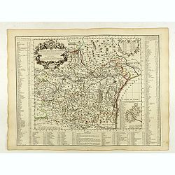
Carte du Diocese de Narbonne.
Topographically detailed map of the Narbonne diocese in southwestern France. Includes major roads and is supplemented with an extensive index. Inset map plan of the forti...
Date: Paris, 1704
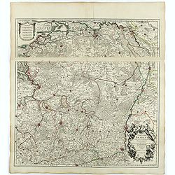
Carte du Brabant.
Map of Brabant with the address : Chez l’Auteur sur le Quai de l’Horloge (address erased after Horloge). Avec privilege du Roy. 1705." Guillaume de l'Isle's (167...
Date: Paris, 1705
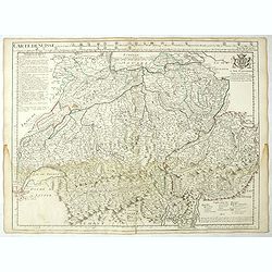
Carte de Suisse ou sont les Cantos de. . .
General map of Switzerland with all the cantons good detail, with the imprint "A Paris Chez l’Auteur sur le Quai de l’Horloge Avec Privilège Aout 1715". In...
Date: Paris, Aout 1715
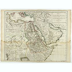
Carte de L'Egypte de la Nubie de L'Abissinie..
Including the Arabian Peninsula. Giving good detail on Egypt. Engraved by Desrosiers. Address and date changed, now with the imprint "A Paris Chez l’Auteur sur le ...
Date: Paris, November 1707

Royaume de Corée.
With a quite elaborately pictorial cartouche, engraved by G.Kondet. One of the earliest separate maps of Korea. Jean Baptiste Bourguignon d' Anville (1697-1782), French c...
Date: The Hague, 1737

Driving chart of Hartford and vicinity : 15 miles around.
Road map by Albert A. Hyde & Co. of Hartford and vicinity, with the Connecticut River in the center. Published by Albert A. Hyde & Co., in New York and lithograph...
Date: New York / Philadelphia, 1884
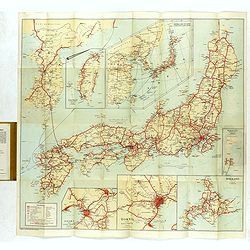
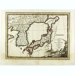
Travellers' Map of Japan, Chosen (Korea), Taiwan (Formosa) with Brief Descriptions of the Principal Tourist Points of Japan.
An early 20th century map which wss published in Tokyo for English speaking tourists.Very detailed set of maps of Japan and parts of Korea, Taiwan and part of China, show...
Date: Tokyo, 1925
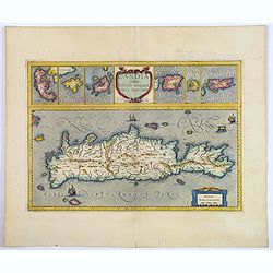
Candia cum Insulis aliquot circa Graeciam.
An attractive (if rather inaccurate) map of Crete, with insets of the islands of Corfu, Zante, Milos, Nicsia, Santorini, and Scarpanto.
Date: Amsterdam, ca 1636
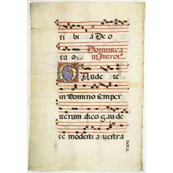
Leaf on vellum from an antiphonary.
A very fine antiphonary leaf, written in Latin, probably Rome. RECTO: A wonderful initial "I" decorated with penwork in red, white and blue, in rich burnished g...
Date: Italy, 1480
Borussiae Regnum compectens Circulos Sambiensem, Natangiensem, et Hockerlandiae Nee non Borussia Polonica, exhibens Palatinatus Culmiensem. . .
Decorative map covering northern Poland with Prussia, Pomerania, Hockerlandia, Warmiaermelandia, Natanglensis, Galindia, Nandrovia, Sclavonia, and the Baltic Sea. Include...
Date: Augsburg, 1759
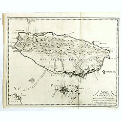
Kaart van het Eyland Formosa en de Eylanden van Piscadores.
The earliest printed map of Taiwan or Formosa. Oriented to the east, with north at the left, covering the entire island and the nearby Pescadores, now known as the Penghu...
Date: Amsterdam, 1724
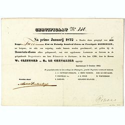
Certificaat N° 230
Text reads "Na primo januarij 1872 is houder dezes geregtigd voor 2/2147 tot hetgeen, ter zake van verjariing, zoude kunnen worden gereclmeerd, uiy gelden bij de Ass...
Date: Amsterdam, 1841
![Le Isole di Sandwich delineate sulle osservazioni del Cap Cook. [Hawaii]](/uploads/cache/43195-250x250.jpg)
Le Isole di Sandwich delineate sulle osservazioni del Cap Cook. [Hawaii]
FIRST EDITION on laid paper. Cassini’s splendid map depicts the Sandwich Islands, the old name for the Hawaiian Islands, at the end of the eighteenth century. The splen...
Date: Rome, 1798

La Nuova Olanda e La Nuova Guinea delineate sulle ultima osservazioni.
Cassini’s splendid and rare map of Australia and New Guinea, from the 'Nuovo Atlante Geografico Universale'. The emphasis of the map is the charting of Captain Cook dow...
Date: Rome, 1798
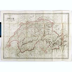
Carte de la Suisse . . .
Detailed canvas map of Switzerland.
Date: Paris, 1850

Carte générale de l' Amérique divisée en ses principaux états . . .
Map of North and South America. By C. F. Delamarche, successor of Robert de Vaugondy, Geographer. Descriptive text to the left.
Date: Paris, 1820
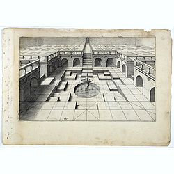
Perspective print by Vredeman de Vries. 38.
Engraving from Perspective, c'est a dire, le tresrenomme art du poinct oculaire d'une veue dedans ou travers regardante, estant sur une muraille unie, sur un tableau, ou ...
Date: The Hague, 1604 - 1605
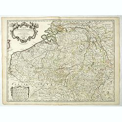
Carte Des Pays Bas Catholiques Dressée. . .
Rare with the address "Chez l’Auteur sur le Quai de l’Horloge a la Cour. ne de Diamans, 1702. Se trouve à Amsterdam chez L. Renard Libraire près de la Bourse.&...
Date: Paris, 1702

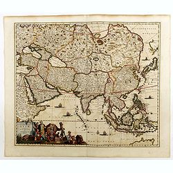
Asia By H.Moll Geographer.
Detailed map of Asia. From his "Atlas minor: or a new and curious set of sixty-two maps. . .", which was first published in 1729 and reprinted in 1732, 1736.The...
Date: London, 1736
![[12 volumes] Recueil des voyages qui ont servi à l'établissement et aux progrez de la Compagnie des Indes Orientales, forméedans les Provinces-Unies des Païs-Bas...](/uploads/cache/43700-250x250.jpg)
[12 volumes] Recueil des voyages qui ont servi à l'établissement et aux progrez de la Compagnie des Indes Orientales, forméedans les Provinces-Unies des Païs-Bas...
An important, richly illustrated compendium of the first Dutch voyages to East India, of great interest for the history and establishment of the Dutch global trade, parti...
Date: Rouen, Pierre Le Boucher, 1725

Tafel der Lender darin der Apostel Paulus geprediget hat.
Rare wood block map depicting the Mediterranean, with an over-sized Cyprus from the final Dutch edition of Heinrich Bünting's famous Itinerarium Sacrae Scripturae, a boo...
Date: Magdeburg, 1581
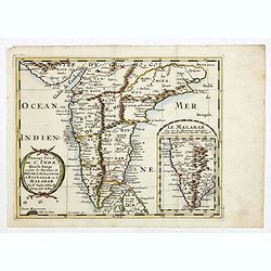
Presqu Isle de L'Inde. deca la Gange.. .
Two maps together on one sheet. General map showing the southern part of India, including the northern part of Shri Lanka. In an inset a detailed map of the most southern...
Date: Amsterdam, 1700
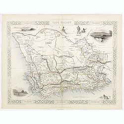
Cape Colony.
A decorative steel engraved map from the famous Victorian publisher John Tallis and Company, published ca.1851. Drawn and engraved by J Rapkin, while the four corner vign...
Date: London, Edinburgh, Dublin, 1851
Grand atlas universel ou collection de cartes encyprotypes, générales et détaillées des cinq parties du monde.
Large folio atlas containing 8 general one-sheet maps, and 8 detailed four-sheet maps: Containing2 World maps- "Mappe-monde sur la projection de Mercator. Carte ency...
Date: Paris, Desray, 1816

Carte du pays de Montenegro dressée d'après les opérations géodétiques . . .
Rare map of Montenegro prepared by Mr. le Comte Fedor de Karacsay (1787-1859) and engraved by Pietro Allodi. The title is in Russian, Arabic and French.In lower left corn...
Date: Vienna, ca. 1838
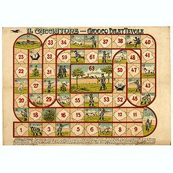
Il cacciatore - Giuoco Dilettevole.
Game of the Goose with 63 numbered boxes, rules in the lower margin. In this game, more players can play and a prismatic die is used with 14 numbers. Whoever goes to the ...
Date: Milan, ca. 1900
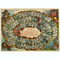
Giuoco dell' Oca. La tentazione
Uncommon Italian Game of the Goose in 90 boxes. The rules of the game are explained as follows: "REGOLA DEL GIUOCO: Questo giuoco è composto di 90 numeri e può ser...
Date: Italy, ca. 1900

A Hysterical Map Of Death Valley National Monument -- And It's Looking Mighty Low
First edition Humorous map of Death Valley. "Drawn In Broken English by Jolly Lindgren," this comic pictorial map is full of puns and comic vignettes related to...
Date: Spokane, Wash., Lindgren Brothers, 1948
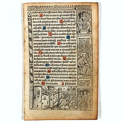
Leaf on vellum from a printed Book of Hours.
24 lines of printed text, surrounded by renaissance borders decorated with scenes and figures.The firm of Thielman Kerver is best known for its lovely printed Books of Ho...
Date: Paris, Philippe Pigouchet for Simon Vostre, ca. 1502
Leaf on vellum from a printed Book of Hours.
24 lines of printed text, surrounded by Renaissance borders decorated with scenes and figures.The firm of Thielman Kerver is best known for its lovely printed Books of Ho...
Date: Paris, Philippe Pigouchet for Simon Vostre, ca. 1502
Leaf on vellum from a printed Book of Hours.
24 lines of printed text, surrounded by renaissance borders decorated with scenes and figures.The firm of Thielman Kerver is best known for its lovely printed Books of Ho...
Date: Paris, Philippe Pigouchet for Simon Vostre, ca. 1502
![[Tartary - Russia]](/uploads/cache/44310-250x250.jpg)
[Tartary - Russia]
Postcard size map in Ottoman script showing Siberia prepared by Mehmet EŞREF in a small atlas : عمومولاياةىشهانيىحاوىكوچكاطلاس [Umum-i vil...
Date: Istanbul, 1325 or 1909

De Zuydwest-Kust van Het Eyland Ceylon.
A finely engraved and detailed chart of Nilwella / Kudawella Harbor.Very rare: only included in the 6th volume (so-called secret atlas) of Van Keulen's. A lettered key in...
Date: Amsterdam, 1753