Recently Listed Listings

Plan de Paris commencé l'année 1734, Dessiné et gravé sous les ordres de Messire Michel Etienne Turgot, prévost des marchands.
FIRST EDITION of Turgot's Monumental Joined View of Paris, stretching to over 10 Feet. This expansive large-scale engraved view of Paris covers the first eleven arrondis...
Date: Paris, 1739
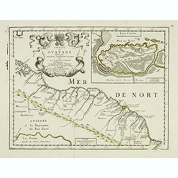
Coste de Guayane autrement Franc Equinoctale en la Terre-Ferme d'Amerique suivant les Dernières Relations . . .
Uncommon map of the French colony Guyana in southern American Guyana, with a detailed enlargement of Cayenne in the upper right corner ( 155X110mm.), with fine title cart...
Date: Paris, 1676
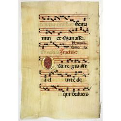
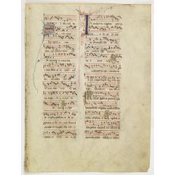
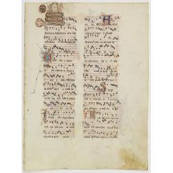
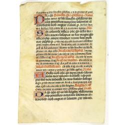
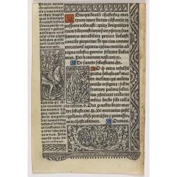
Leaf on vellum from an antiphonary.
A very fine antiphonary leaf, written in Latin , probably Rome. RECTO: The staves are in red and the notes in black. VERSO: The staves are in red and the notes in black. ...
Date: Italy, 1480

De Stadt Jerusalem.
Plan of ancient Jerusalem from a Dutch bible after Villalpando. The print is in contemporary colors, which is extremely rare for a plate like this. Lower left the Temple ...
Date: Amsterdam, 1710

Carte la plus generale et qui comprend la Chine, la Tartarie chinoise et le Thibet. . .
It has a quite elaborate pictorial cartouche engraved by G. Kondet. It is a very detailed map of China, Tibet, and Korea.In the upper left corner is very good details of ...
Date: The Hague, 1737
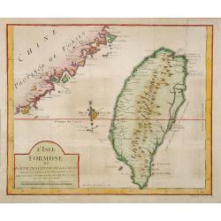
L'Isle Formose et parties des Costes de la Chine. . .
This well-known map of Taiwan was prepared by Jacques Nicolas Bellin and was based on Jesuit information. The text along the island's east coast claims: Of this coast, ...
Date: Paris, 1763
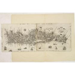
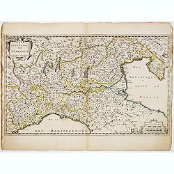
Il Regno Di Candia.
This rare map is based on the important map of Crete by Basilicata. The maps by Marco Boschini reached a wider audience than the few individuals for whom the Basilicata m...
Date: Venice, 1660

Ducatus Limburg.
A very rare issue of this map of Limburg. Cornelis Danckerts II copied the folio map of H.Hondius.The publisher's address was placed in the lower right-hand corner. The c...
Date: Amsterdam, 1636

Nouvelle et exacte Carte du Duche de Brabant. . .
A very rare example of a map of the Duchy of Brabant. Title cartouche in the lower left-hand corner. A very rare issue of this map of Brabant. Cornelis Danckerts II. copi...
Date: Amsterdam, 1635
Leaf on vellum from an antiphonary.
A more than 600 years old antiphonary leaf, written in Besançon, in 1370. Musical notation on 4 bars, the staves are in red and the notes in black: numerous pen-flourish...
Date: France, Besançon, 1370
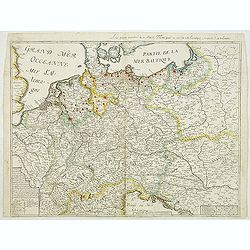
Carte generalle d'allemaigne nouvellement misse en françois et Ampliffiée de tous les Royaumes. . .
Attractive and rare map of Germany, the Low Countries, Austria, Moravia, Switzerland and part of Poland.
Date: Paris, 1632-1660
Ducato di Luxembourgo . . .
A beautiful and flamboyantly engraved map of Luxembourg. The map is the product of the late 17th century Venetian cartographer, Vincenzo Coronelli. A decorative title car...
Date: Venice, 1698
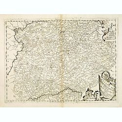
Carte Générale de Lombardie.
Fine map of Northern and middle part of Italy, engraved by A Peyrouin. According to the credit in the cartouche the map has been prepared by Pierre Duval.
Date: Paris, ca. 1650
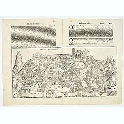
Destruccio Iherosolime.
The view shows the destruction of Jerusalem. Major points in the city are identified with Latin notations. Of interest, in the upper left of the image are two figures...
Date: Nuremberg, 12 July 1493
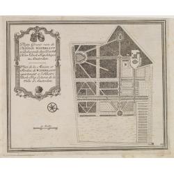
Gemete Kaerte van de Stede Beverwyk, zoo als die tegenwoordigh zich vertoont.
Uncommon plan of Beverwijk made in the year 1739. Published in Hollandsche Arcadia. Title in Dutch and French.
Date: Amsterdam, ca.1740
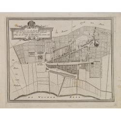
Platte Gront van de Hofstede Waterlant toebehorende den Ed. Achtb. Heer Dirk Trip Schepen te Amsterdam.
Uncommon plan of Hofstede Waterlant. Published in Hollandsche Arcadia. Title in Dutch and French "Plan de la Maison et Jardins appartenant a l'Illustre Dirk Trip Ech...
Date: Amsterdam, 1740

Carte D'Amerique Divisée en ses Principaux Pays. . .
Rare. Uncommon and decorative wall map of America, prepared by Clouet. With superb decorative borders, 170mm wide at the sides and 150mm at the bottom, containing twenty ...
Date: Paris, Cadiz, 1785
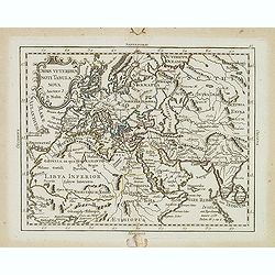
Orvis veteribus novi tabula nova. . .
Scarce map of the Ancient world, prepared by Nolin and published by L.J. Mondhare for his Atlas Général a l'usage des colleges et maisons d'education.. Louis Joseph Mon...
Date: Paris, 1781
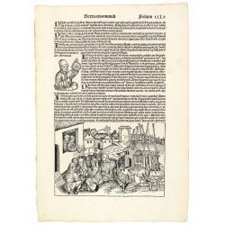
Sexta Etas Mudi. Folio CCLV. (With portret of Johannes Müller alias Regiomontanus holding a Astrolabe.
A very fine presentation of the astronomer Johannes Müller alias Regiomontanus holding a Astrolabe. A village-scene (Dim. H : 150 mm W : 223 mm) is depicted on the lower...
Date: Nuremberg, 12 July 1493

Pianta Della Citta di Roma con la Indicazione di tutte le Antichita e Nuovi Abbelliment.
Beautifully engraved town plan of Rome, featuring side borders that depict the 16 most important monuments, along with a legend that locates the significant places and bu...
Date: Venanzio Monaldini, Rome, 1829
![Une Kirguisiene par devant. [together with] Une Kirguisienne par derriere.](/uploads/cache/32991-250x250.jpg)
Une Kirguisiene par devant. [together with] Une Kirguisienne par derriere.
Uncommon copper-engraved costume plate showing two natives of Kyrgyzstan, a Central Asian country along the Silk Road, the ancient trade route between China and the Medit...
Date: St. Petersbourg, C.G. Müller, 1776-1780
![Sexta Etas Mundi. Constancia. [Constance CCXLI ]](/uploads/cache/33141-250x250.jpg)
Sexta Etas Mundi. Constancia. [Constance CCXLI ]
A very fine town view of Constance, in Germany, centered on the cathedral (198 x 520 mm).VERSO, seven insets of scientists, noblemen and Popes.Page from the richest illus...
Date: Nuremberg, 12 July 1493
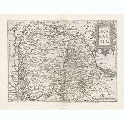
Brabantia.
Map of Brabant from Guicciardini's "Description de touts les Pais-Bais" edited by Plantin in 1582. The map drawn after Ortelius' map of Brabant, and after the l...
Date: Antwerp, 1582
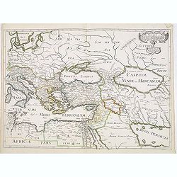
Romani Imperii Oriens est Descriptio Geographica. . .
A fine map of the Near East. The map was first published by Tavernier and later by Mariette. This edition is dated 1637 with the address of Pierre Mariette at rue S. Jacq...
Date: Paris, after 1637

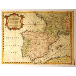
Tabula Secunda Europe (Spain & Portugal)
Wood block printed large-format Ptolemaic map of the Iberian Peninsula from the 1513 edition of Waldseemüller's Geographia.This Ptolemaic map comes from the first so cal...
Date: Strasburg, 1513
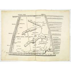
Octava Asie Tabula (The Silk Road Area.)
Woodblock printed large-format map showing Northern India with Central Asia including the Himalayas and China. From the 1513 edition of Waldseemüller's Geographia.In the...
Date: Strasburg, 1513

Carte von West=Gallizien welche auf allerhöchsten Befehl Seiner Kaiserlich oesterreichischen und Königlich apostolischen Majestät in den Jahren 1801 bis 1804. . .
Important early map of Western Galicia, as given to Austria by the third Partition of Poland (1795). Due to its lengthy development period, a rare map rich in detail depi...
Date: Vienna, (1808) after 1811
Quinta Etas Mundi. Folium. LXVI. (Visionary Temple of Ezekiel.)
The Latin text page is illustrated with recto and verso depictions of the visionary Temple of Ezekiel. Kings.Page from the richest illustrated Incunable, the famous: Chro...
Date: Nuremberg, 12 July 1493
Quinta Etas Mundi. Folium.XCIII.
The Latin text page is illustrated with depictions of Caius Julius Caesar, Octavian (Octavianus) Augustus and Mark Antony (Marcus Antonius). VERSO : A wonderful woodcut (...
Date: Nuremberg, 12 July 1493

Schlavoniae, Croatiae, Carniale.. Bosniae. . .
First state. Fine and early map of former Yugoslavia after a map of Hirschvogel (1552-1565) and used by A.Ortelius in his atlas 'Theatrum Orbis Terrarum [Atlas of the Who...
Date: Antwerp, 1579
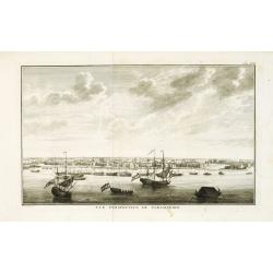
Vue de la Rade et de la Ville de Paramaribo.
A very decorative panoramic view of the town with a large Dutch vessel in the foreground. Engraved by Noach van der Meer Junior. Included in a Dutch edition of "Hist...
Date: Amsterdam, 1774
![Matelot Hollandais [Dutch sailor]](/uploads/cache/28927-250x250.jpg)
Matelot Hollandais [Dutch sailor]
Etching showing a typical Dutch sailor, after Jacques Grasset de Saint-Sauveur (1757–1810). Taken from "Costumes Civils actuels de tous les peuples connus, dessin�...
Date: Paris, Pavard, 1788

Tabula Episcopatuum Leodiensis et Coloniensis. . .
Rare issue of Cornelis Danckert's attractive map of Limburg, shows the area of Cologne, Mainz, Trier, Jülich, Mons, Antwerp and Liege in Belgium.Decorative title cartouc...
Date: Amsterdam, 1700

Map of the Great Salt Lake And Adjacent Country in the Territory Of Utah. Surveyed in 1849 and 1850, under the orders of Col. J.J. Abert ...
Map of the Great Salt Lake And Adjacent Country in the Territory Of Utah. Surveyed in 1849 and 1850, under the orders of Col. J.J. Abert .. by Capt. Howard Stansbury .. a...
Date: Ackerman, New York, 1852
![[Set of 6 maps] Charta öfver Storfurstendömet Finland på Friherre S. G. Hermelins Anstalt och Omkostnad. Sammandragen och författad af C. P. Hällström. Philos. Magister och Auscultant i Kongl. BergsColl. 1799.](/uploads/cache/34482-250x250.jpg)
[Set of 6 maps] Charta öfver Storfurstendömet Finland på Friherre S. G. Hermelins Anstalt och Omkostnad. Sammandragen och författad af C. P. Hällström. Philos. Magister och Auscultant i Kongl. BergsColl. 1799.
This is a beautiful set of a key map and five separate maps of Samuel Gustav Hermelin's map of Finland. The maps have been engraved by Fredrik Akrel, a very skilled and p...
Date: Källa: J.Strang & E.- S. Harju: Suomen karttakirja 1799
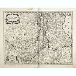
Ducatus Geldriae novissima. . .
Early map of Gelderland, but also including Utrecht, and parts of Brabant. Shows many cities (like Nijmegen, Eindhoven, Zutphen, Zwolle, etc), roads, rivers, woods, regio...
Date: Amsterdam, 1629-1630
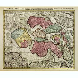
Zeelandiae Comitatus. . .
Scarce map of Zeeland, this is the state published by Tobias Conrad Lotter, previously published by Matthäus Seutter.Impressive cartouche with coat of arms of Zeeland to...
Date: Augsburg, c.1760
Leaf on vellum from an antiphonary.
A more than 600 years old antiphonary leaf, written in Besançon, in 1370. Musical notation on 4 bars, the staves are in red and the notes in black: numerous pen-flourish...
Date: Besançon, 1370
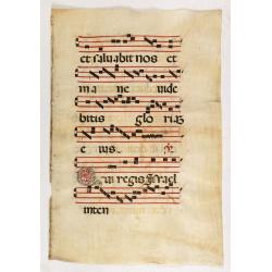
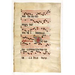
Leaf on vellum from an antiphonary.
A large vellum antiphonary leaf, written in Latin , probably Rome. RECTO: A wonderful initial "Q",, decorated with penwork in red, white and blue, in rich burni...
Date: Italy, 1480
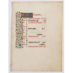
A manuscript leaf from a Book of Hours. (Calendar month of August)
RECTO : Calendar month of August with a 2-line initial in liquid gold on colored ground. colorful panel border in the left margin of acanthus leaves and flowers, with bla...
Date: Paris, ca. 1450
Leaf on vellum from a antiphonary.
A leaf from a Medieval Antiphonal or Choir Missal for Spanish use, in Latin on extremely heavy vellum. Justification: 360x246mm. Text is in Spanish rounded gothic hand (R...
Date: Sevilla, ca.1520
Leaf on vellum from an antiphonary.
A very fine antiphonary leaf, written in Latin , probably Rome. RECTO: A wonderful initial ,O, decorated with pen work in red, white and blue, in rich burnished gold.VERS...
Date: Italy, 1480

Tartaria.
Published in Hondius' editions of the Mercator Atlas from 1606 onwards, China, Korea, and the northern Pacific coast of America are shown as two continents separated by t...
Date: Amsterdam, 1633
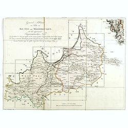
(Index sheet) General Tableau zur Karte von Alt Ost und West Preussen nebst dem aufgenommenen Trigonometrischen Netz. . .
Index sheet of this important multi-sheet map of Prussia, Lithuania, and Poland.Section XXIV of the rare first edition of this important 25-sheet map prepared by Friedric...
Date: Berlin, 1802-1810
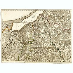
(Sheet X with Puk Bay from) General Tableau zur Karte von Alt Ost und West Preussen nebst dem aufgenommenen Trigonometrischen Netz. . .
Sheet IV with Zalew Wislany and the towns of Elblag, Paslek, Braniewo, etc, of this important multi-sheet map of Prussia, Lithuania, and Poland.The rare first edition of ...
Date: Berlin, 1802-1810

Map of Russia and Poland.
Charming, folding map of Russia, Poland and Baltic States, still in its original publisher's blind stamped linen wrapper with yellow label. With yellow advertisements at ...
Date: London, ca. 1894

A Map of the most Inhabited part of New England containing the Provinces of Massachusetts Bay and New Hampshire, with the Colonies of Connecticut and Rhode Island.
A copper engraving in four sheets, published in Georges Louis Le Rouge, in his "Atlas Ameriqua in Septentrional Contenant les details des differentes provinces, de c...
Date: Paris, 1777
Leaf on vellum from a printed Book of Hours.
21 Lines of printed text, surrounded by renaissance borders decorated with putti, flowers and Middle French script around the illustrations.Interesting are the 6 panels w...
Date: Paris, Philippe Pigouchet for Simon Vostre, ca. 1502
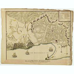
Plan of the City of Barcelona.
From Rapin's History of England , a nicely detailed plan of Barcelona, the capital of Catalonia. The plate contains a 19 point legend and the presentation is enhanced wit...
Date: London, c.1745
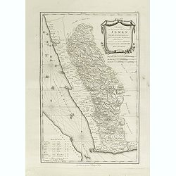
Karte von dem groessten Theil des Landes Jemen Imame, Kaukeban &c.
Large map of Yemen from "Allgemeiner grosser Atlas" published by P. J. Schalbacher - 1786-1800. Based on the observations of the Danish explorer Carsten Niebuhr...
Date: Vienna, 1789
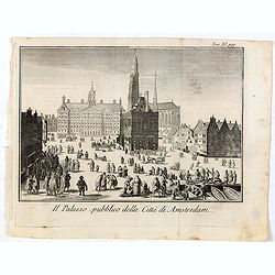
Il Palazzo pubblico della Citta di Amsterdam.
Fine panoramic views of the Dam square in Amsterdam, taken from Storia moderna di tutti I popoli del mondo , edited by Thomas Salmon. A Italian edition of this famous wor...
Date: Venice, 1740-1756
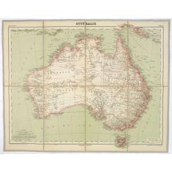
AUSTRALIE
Detailed folding maps of Australia. In upper left corner "Atlas Universal" and in upper right corner "Carte 78".In lower left "Dessiné: le trait...
Date: Paris, ca. 1930
Historic Map - Naaukeurige Kaart Van Tartaryen, Soo als dat door W De Rubruquis doorreyst.
This attractive map published by Pieter van der Aa, shows Tartary abd the ancient Silk Road region. The map shows the track of William of Rubruck (Willem van Rubroeck or ...
Date: Amsterdam, 1713-1729

A plat of the East Sea. By William Fisher and Richard Mount...
An important sea chart of the East Sea with coast lines of Poland, Russia, Sweden, published by William Fisher and Richard Mount in London.Richard Mount (1654-1722) was a...
Date: London, 1695
Westphalia Ducatus.
Originally engraved for Jodocus Hondius II, at his death in August 1629 this map was, among 39 other copper plates,purchased by Willem Blaeu who deleted Hondius' name and...
Date: Amsterdam, 1634
Selling price: ????
Please login to see price!
Sold in 2025
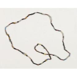
Dutch Trade Bead.
An extremely rare necklace made from authentic early 17th-century glass beads produced in the Netherlands. This rare and early Dutch Trade bead is built up from irregular...
Date: Middelburg, before 1623
A New and Accurate Map of the Kingdoms of Spain, Portugal and Part of France, The Islands of Majorca, Minorca &c.
Produced for “Universal Magazine” by J. Hinton. It was engraved by Richard William Seale (1703-1762). The map features an attractive rococo cartouche and compass ros...
Date: London, ca. 1760

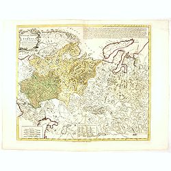
Russia & Poland.
Charming, folding map of Russia and Poland, giving a detailed overview of Europe from Baltic to Caspian Sea. Railways and rivers prominently delineated.In lower left a ke...
Date: London, ca. 1890
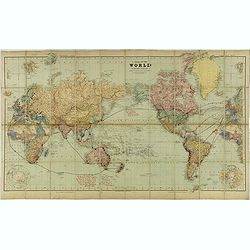
A Chart of the World on Mercator's Projection Shewing the Principal Ocean Steam Routes, the Submarine Telegraphs &c.
Charming, folding world map on Mercator's projection showing extensive steam routes and underground and undersea telegraph cables. The map is annotated in blue and red wi...
Date: London, ca. 1890
![[8 sheets - Partie du THIBET]](/uploads/cache/36629-250x250.jpg)
[8 sheets - Partie du THIBET]
A set of 8 maps covering Tibet region and the Himalayas.From his famous Atlas Universel . This atlas was one of the most remarkable world atlases ever produced, anticipat...
Date: Brussels, 1825-1827

Romani Imperii Imago.
Very rare map in a first edition by Jacques Honervogt. Copied after a map by Ortelius but much rarer. The medallion portraits are of Romulus and Remus - the genealogical ...
Date: Paris, 1630
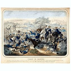
Combat de Palestro.
Showing the battle of Palestro lithographed by E.S. Walter and printed by De Becquet and published by Rousselot in Paris.The lithograph is part of a series of prints publ...
Date: Paris, ca. 1860
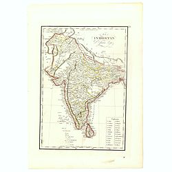
El Indostan por D. Juan Lopez.
Uncommon map of India and Shri Lanka published by Juan Lopez (1765-1830) and included in his "Atlas Universal o collection de mapas nuevos. . ." first published...
Date: Madrid, 1817
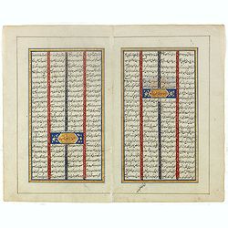
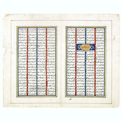
Double page manuscript page from a Shahnameh, The Book of Kings, written by Ferdowsi.
Fine double page brilliantly illuminated gilt leaves written by the scribe Abu Bakr Jami in Isfahan. The Arabic text contains Islamic prayers with beautiful headings thro...
Date: Isfahan, ca. 1780

Carte du Golphe du Mexique et des Isles de l'Amerique.
Attractive map of the islands of the Caribbean that includes those parts of the United States & Mexico that border the Gulf of Mexico, Central America, and the northe...
Date: Paris, 1754
Russian Empire in Europe from the Dr. D'Anville of the Royal Academy. . .
Rare map of Russia, prepared by John Bayly (active 1755-1794) after D'Anville. In the lower-left corner parts of the Caspian and Black Sea. In the upper right corner Nova...
Date: London, ca. 1782
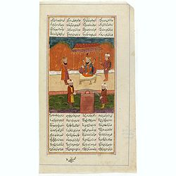
Manuscript page from a Shahnameh, The Book of Kings, written by Ferdowsi.
Page with large miniature 187 x 160mm. from the Shahnameh, or ("The Book of Kings"), which is a long epic poem written by the Persian poet Ferdowsi between c. 9...
Date: Kashmir, ca. 1830-1860
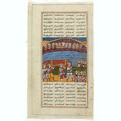
Manuscript page from a Shahnameh, The Book of Kings, written by Ferdowsi.
Page with large miniature 160 x 160mm. from the Shahnameh, or ("The Book of Kings"), which is a long epic poem written by the Persian poet Ferdowsi between c. 9...
Date: Kashmir, ca. 1830-1860
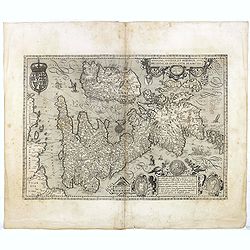
Angliae, Scotiae, et Hiberniae, sive Britannicar : Insularum descriptio.
A rare and ornate map with inset portraits of James First, Henry Prince of Wales Princess Anne of Denmark.Janssonius acquired the copperplate of van den Keere's 1604 Brit...
Date: Amsterdam, 1621
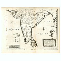
Carte du Golfe de Bengale, Mer de Indes, et Riviere du Gange, Avec les Pais et Iles d'alentour, Savoir les Cotes de Malabar, Cormandel, Ile de Ceylon, Les Maldives . . .
Detailed map of the Southern part of India with Ceylon. Good detail along the coasts of Malabar, Coromandel, the Maldives islands and the Kingdoms of Visipour, Golconda, ...
Date: Leiden, 1719
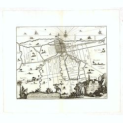
A Mapp of Batavia with all itts Forts.
Wonderful, scarce, and decorative plan of present-day Jakarta, showing the City and its immediate environs, the surrounding rice fields intersected by a network of waterw...
Date: London, Printed for A. and J. Churchill, 1703
Double page manuscript page from a Shahnameh, The Book of Kings, written by Ferdowsi.
Fine double page brilliantly illuminated gilt leaves written by the scribe Abu Bakr Jami in Isfahan. The Arabic text contains Islamic prayers with beautiful headings thro...
Date: Isfahan, ca. 1780

(View of the Moscow Kremlin, seen from the Moskva River in the south).
Anonymous, likely Russian School gouache drawing of Moscow Kremlin. The Kremlin is depicted in a typical 19th century romantic style and is seen from the Moskva river in ...
Date: Russia, ca. 1850

Nouveau théâtre de la guerre entre les Russes les turcs et les polonois confédérés.
A very rare separately published map of Crime region. With a large title cartouche lower left "Nouveau theâtre de la guerre entre les russes, les turcs et les polon...
Date: Paris, 1769
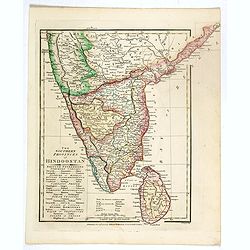
The Southern provinces of Hindoostan . . .
An attractive map showing Hindoostan and Ceylon. Shows towns, rivers, mountains, lakes, etc. In pretty original wash colors. Robert Wilkinson was active in London as a ca...
Date: London, 1808
![Narsinga. [India]](/uploads/cache/38123-250x250.jpg)
Narsinga. [India]
Small map illustrating the Indian peninsular. Oriented with East on top, surrounded by text in Dutch.Nicolaes de Clerck (de Klerc) was active as engraver and publisher in...
Date: Amsterdam, Cloppenburch, 1621
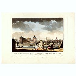
Vue de la ville de St. Pétersbourg capitale de la russie prise du côté de la Fontanka . . .
This aquatint print figures the town of St. Peterburg. With address "A Paris chez le Coeur graveur, rue Mouffetard, N° 89 et chez Bance aîné, rue Saint Denis, N°...
Date: Paris, Le Cœur et Bance ainé, ca 1814
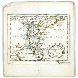
Presqu''isle de L'Inde de ça le Gange.
Uncommon miniature map of India from Pierre Duval's La Geographie Universeille dated 1676. Following his Cartes de geographie in 1657, Pierre Duval published this smaller...
Date: Paris, 1676

Langley's New Travelling and Commercial Map . . .
A highly desirable, detailed and uncommon map of England and Wales, published by Langley and Belch. The map is flanked by a pair of large and detailed explanation tables,...
Date: London, 1817

Karte der Ukraina.
A large political, economical and transportation map of Ukraine, printed three months after the beginning of the WW II in Ukraine. Shows the newest borders, streets and r...
Date: Vienna: Freytag u. Bernd u. Artaria August 1941