Recently Listed Listings
![[Marquesas Islands headdresses and head ornaments ].](/uploads/cache/26374-250x250.jpg)
[Marquesas Islands headdresses and head ornaments ].
Aquatint depicting Marquesas Islanders in traditional headdresses and a variety of head ornaments engraved by Bonatti. Plate N° 90. From Giulio Ferrario's work Le Costum...
Date: Milan, 1827
![[Easter Island inhabitants ].](/uploads/cache/26375-250x250.jpg)
[Easter Island inhabitants ].
Aquatint depicting 2 portraits of Easter Island inhabitants and 2 men rowing in a pirogue. Engraved by Carlo Bottigella. Plate N° 88. From Giulio Ferrario's work Le Cost...
Date: Milan, 1827
![[Women dancing in a Ulietea house ].](/uploads/cache/26376-250x250.jpg)
[Women dancing in a Ulietea house ].
Aquatint depicting women dancing in front of musicians and local villagers in a Ulietea house. Plate N° 87. From Giulio Ferrario's work Le Costume Ancien et Moderne ou H...
Date: Milan, 1827
![[Tahitian warrior dugouts ].](/uploads/cache/26377-250x250.jpg)
[Tahitian warrior dugouts ].
Aquatint depicting a view of Tahitian warrior dugouts engraved by Fumagalli. Plate N° 86. From Giulio Ferrario's work Le Costume Ancien et Moderne ou Histoire du gouve...
Date: Milan, 1827
![[Tahitian tools ].](/uploads/cache/26378-250x250.jpg)
[Tahitian tools ].
Aquatint depicting a variety of Tahitian tools engraved by Rivelanti. Plate N° 85. From Giulio Ferrario's work Le Costume Ancien et Moderne ou Histoire du gouvernement...
Date: Milan, 1827
![Mortuary scene. Tahiti Islands ].](/uploads/cache/26380-250x250.jpg)
Mortuary scene. Tahiti Islands ].
This aquatint depicts a mortuary scene in front of a tapapow, a shed under which the dead bodies remains are exposed until they dry. Engraved by Roffi. Plate N° 83. From...
Date: Milan, 1827
![[Queen Obera welcoming Captain Wallis. Tahiti ].](/uploads/cache/26381-250x250.jpg)
[Queen Obera welcoming Captain Wallis. Tahiti ].
Aquatint depicting Queen Obera welcoming Captain Wallis upon his arrival in Tahiti. Engraved by Gallina. Plate N° 82. From Giulio Ferrario's work Le Costume Ancien et Mo...
Date: Milan, 1827
![[The Friendly Islands ].](/uploads/cache/26384-250x250.jpg)
[The Friendly Islands ].
Aquatint depicting seashore scene of the Friendly Islands. These islands are also known as the Friendly Islands because of the friendly reception accorded to Captain Cook...
Date: Milan, 1827
![[Portraits. Friendly Islands ].](/uploads/cache/26385-250x250.jpg)
[Portraits. Friendly Islands ].
Aquatint depicting inhabitants of the Friendly Islands. Plate N°79. From Giulio Ferrario's work Le Costume Ancien et Moderne ou Histoire du gouvernement, de la milice, d...
Date: Milan, 1827
![[Scene of a meeting. The Friendly Islands ].](/uploads/cache/26386-250x250.jpg)
[Scene of a meeting. The Friendly Islands ].
Aquatint depicting an indoor meeting in the Friendly Islands. Plate N°79. From Giulio Ferrario's work Le Costume Ancien et Moderne ou Histoire du gouvernement, de la mil...
Date: Milan, 1827
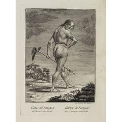
Uomo del Paraguai nell' America Meridionalle. / Homme du Paraguai dans l'Amerique Meridionalle.
Full portrait of a person from Paraguay. From "Raccolta di stampe." a series of historically significant eighteenth-century copper plate engravings by Venetia...
Date: Venice, Antonio Zatta, c.1790
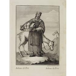
Indiana del Perù. / Indienne du Perou.
Portrait of a Peruvian Indian woman holding a fruit basket and a lama in the background. From "Raccolta di stampe." a series of historically significant eight...
Date: Venice, Antonio Zatta, c.1790
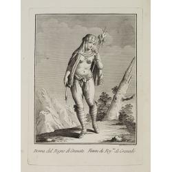
Dona del Regno di Granata. / Femme du Roy.me de Granade.
A full portrait of a woman from Granada, situated at Lake Nicaragua or Cocibolca. From "Raccolta di stampe", a series of historically significant eighteenth...
Date: Venice, Antonio Zatta, c.1790
![Donna dell' Isola d' Erramanga una delle nuove Ebridi nel Mar Pacifico. / Femme de l'Isle d'Erramanga une des nouvelles Hebrides dans la Mer Pacifique. [Vanuatu]](/uploads/cache/26396-250x250.jpg)
Donna dell' Isola d' Erramanga una delle nuove Ebridi nel Mar Pacifico. / Femme de l'Isle d'Erramanga une des nouvelles Hebrides dans la Mer Pacifique. [Vanuatu]
Full portrait of a woman, native of the island of Erramanga in the New Hebrides, officially the New Hebrides Condominium, the colonial name for the island group in the So...
Date: Venice, Antonio Zatta, c.1790
![Donna dell' Isola di Mallicolo una delle nuove Ebridi nel Mar Pacifico del Sud. / Femme de l' Isle d'Erramanga... [Vanuatu]](/uploads/cache/26397-250x250.jpg)
Donna dell' Isola di Mallicolo una delle nuove Ebridi nel Mar Pacifico del Sud. / Femme de l' Isle d'Erramanga... [Vanuatu]
Full portrait of a woman, a native of the island of Mallico in the New Hebrides, officially the New Hebrides Condominium, the colonial name for the island group in the So...
Date: Venice, Antonio Zatta, c.1790
![Donna dell' Isola di Tanna, una delle nuove Ebridi nel Mar Pacifico. / Femme de l' Isle de Tanna, une des nouvelles Hebrides dans la Mer Pacifique. [Vanuatu]](/uploads/cache/26398-250x250.jpg)
Donna dell' Isola di Tanna, una delle nuove Ebridi nel Mar Pacifico. / Femme de l' Isle de Tanna, une des nouvelles Hebrides dans la Mer Pacifique. [Vanuatu]
Full portrait of a woman, a native from the island of Mallico in the New Hebrides, officially the New Hebrides Condominium, the colonial name for the island group in the ...
Date: Venice, Antonio Zatta, c.1790
![Uomo dell' Isola di Tanna, una delle nuove Ebridi nel Mar Pacifico. / Homme de l' Isle de Tanna, une des nouvelles Hébrides dans la Mer du Pacifique. [Vanuatu]](/uploads/cache/26399-250x250.jpg)
Uomo dell' Isola di Tanna, una delle nuove Ebridi nel Mar Pacifico. / Homme de l' Isle de Tanna, une des nouvelles Hébrides dans la Mer du Pacifique. [Vanuatu]
Full portrait of a man from the island of Tanna in the Pacific. New Hebrides, officially the New Hebrides Condominium was the colonial name for the island group in the So...
Date: Venice, Antonio Zatta, c.1790
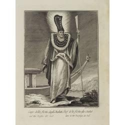
Capo della flotta degli Otahiti nel Mar Pacifico del Sud. / Chef de la flotte des Otahiti dans la Mer Pacifique du Sud.
Full portrait of the captain of the Otahiti flotilla, from Tahiti. A rare engraving from "Raccolata di stampe ... di varie nazioni". From the original drawing...
Date: Venice, Antonio Zatta, c.1790
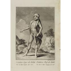
Potatow Capo dei Tahiti Isola nel Mare Pacifico del Sud. / Potatow Chef de Tahiti Isle dans la Mer Pacifique du Sud.
Full portrait of the Hawaiian chief Potatow. A rare engraving from "Raccolata di stampe ... di varie nazioni". From the original drawing by William Hodges, w...
Date: Venice, Antonio Zatta, c.1790
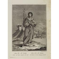
Otoo, Re di Tahiti Isola nel Mar Pacifico del Sud. / Otoo, Roi de Tahiti Isle dans la Mer Pacifique du Sud.
Full portrait of King Otoo from Tahiti. A rare engraving from "Raccolata di stampe ... di varie nazioni". From the original drawing by William Hodges, who acco...
Date: Venice, Antonio Zatta, c.1790
Donna dell' Isola di Pasqua, o terra di Davis nel Mar del Sud. / Femme de l' Isle de Pâques ou terre de Davis dans la Mer du Sud.
Full portrait of a woman, a native of Easter Island, a Chilean territory, is a remote volcanic island in PolynesiaFrom "Raccolta di stampe." a series of histori...
Date: Venice, Antonio Zatta, c.1790
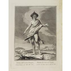
Uomo dell' Isola di Pasqua o Terra di Davis nel Mar del Sud. / Homme de l' Isle de Pâquesou Terra de Davis dans la Mer du Sud.
Full portrait of a native from Easter Island. Easter Island, a Chilean territory, is a remote volcanic island in Polynesia.From "Raccolta di stampe," a series o...
Date: Venice, Antonio Zatta, c.1790
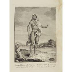
Donna dell' Isola di S.a Cristina una delle Marchesi nel Mar del Sud. / Femme de l' Isle de S.e Christine une des Marquises dans la Mer du Sud.
Full portrait of a woman from the Saint Christina Island. A rare engraving from "Raccolata di stampe ... di varie nazioni". From the original drawing by Willia...
Date: Venice, Antonio Zatta, c.1790
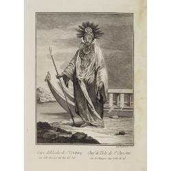
Capo dell' Isola di S.a Cristina una delle Marchesi nel Mar Pacifico del Sud. / Chef de l'Isle de Ste. Christine une des Marquises dans la Mer Pacifique du Sud.
Full portrait of the Chief of the Saint Christina Island. A rare engraving from "Raccolata di stampe ... di varie nazioni". From the original drawing by William...
Date: Venice, Antonio Zatta, c.1790
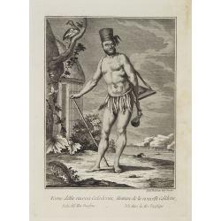
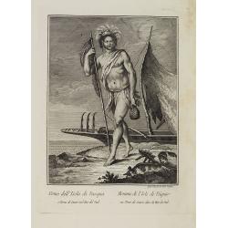
Uomo della nuova Caledonia Isola del Mar Pacifico. / Homme de la nouvelle Calédonie Isle dans la Mer Pacifique.
Full portrait of a native from New Caledonia. A rare engraving from "Raccolata di stampe ... di varie nazioni". From the original drawing by William Hodges, who...
Date: Venice, Antonio Zatta, c.1790

Vorstellung Einiger Gegenden und Plaetze in Nord-America unter Franzoesisch und Englische Jurisdiction Gehoerig zu Finden bey den Homaennischen Erben in Nurnberg Ao. 1756.
Three town plans on one sheet of eastern Canada, including Quebec, Louisbourg and Halifax towns which the English and French fought to conquer on the American continent f...
Date: Nuremberg, 1756

Il vero ritratto di Nettvno al presente oaupato da gl'imperiali.
Rare and early town-plan of Nettuno, in the province of Rome, which is nowadays a touristic harbor.Issued by Joannes Orlandi who acquired many Lafreri plates, which he re...
Date: Rome, 1557 / 1602
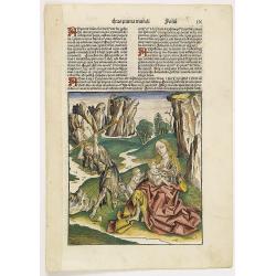
![[Text page with Saint Appolonia, the patron saint of dentistry. - Sexta Etas Mundi. Folium. CXX ].](/uploads/cache/26526-250x250.jpg)
[Text page with Saint Appolonia, the patron saint of dentistry. - Sexta Etas Mundi. Folium. CXX ].
Text page with woodcuts of Abdon & Senen, Agatha, Appolonia, Serapion, Meniacus, Victoria. With a woodcut of Appolonia, the patron saint of dentistry. Because of the ...
Date: Nuremberg, 12 July 1493

Pascaerte Van't Westelyckste der Middelandsche Zee. . .
An eye-catching chart of the western part of the Mediterranean Sea.Pieter Goos (ca. 1616-1675) was one of the most important cartographer, engraver, publisher and print s...
Date: Amsterdam, 1666
![[Page with imaginary towns in Hungary. ] CCLXVIII](/uploads/cache/26932-250x250.jpg)
[Page with imaginary towns in Hungary. ] CCLXVIII
Page with imaginary towns in Hungary (230x225mm.) This leaf is from an edition of Hartmann Schedel's Liber chronicarum or Nuremberg Chronicle. The Chronicle was published...
Date: Nuremberg, 1493

Plan de Constantinople, non compris ses faubourgs. Grave d'apres les documents du ministere de la Guerre par E. Olivier.
A very rare lithographic large-scale town-plan of Istanbul, Scale 98 yards to one inch., printed in Pera, Istanbul by E. Olivier. The ornate design on the top of the...
Date: Péra, Istanbul, 1851
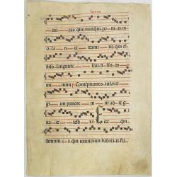
Leaf on vellum from a antiphonary.
A leaf from a Medieval Antiphonal or Choir Missal for Spanish use, in Latin on extremely heavy vellum. Justification: 370x250 mm. Text is in Spanish rounded gothic hand (...
Date: Sevilla, ca.1520
![[ Secunda etas mundi. Foliu XVIII ].](/uploads/cache/26866-250x250.jpg)
[ Secunda etas mundi. Foliu XVIII ].
Text in Latin, each paragraph separated by the triumphant cross with orb representing Christ's reign over the world (it is often shown atop Christ's scepter in Christian ...
Date: Nuremberg, 12 July 1493
![[Text page with Kings and historical personalities.] Quita etas mundi. Foliu. LXXXIII](/uploads/cache/26874-250x250.jpg)
[Text page with Kings and historical personalities.] Quita etas mundi. Foliu. LXXXIII
Text page with woodcuts of Kings and historical personalities.Page from the richest illustrated Incunable, the famous: Nuremberg Chronicle, published the year that Columb...
Date: Nuremberg, 12 July 1493
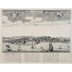
Lisbona.
A rare panoramic view of Lisbon with over the whole length of the lower part 3 columns of poems in Latin, Dutch and French.Published by Dancker Danckerts (1634-1666)Colle...
Date: Amsterdam, 1660

Gustaaf Willem Baron van Imhoff.
Decorative portrait of Gustaaf Willem Baron van Imhoff, who was Governor for the V.O.C. (Dutch East Indian Company) in Indonesia.
Date: Amsterdam, 1745
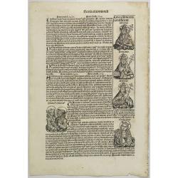
Text page with Kings, Queens, Saints and Popes. Sexta Etas Mundi. Folium. CXVI.
Recto verso text page with woodcuts of Kings, Queens, Saints (St.Cecilia), Popes and historical personalities. Page from the richest illustrated Incunable, the famous ...
Date: Nuremberg, 12 July 1493
![[ Spitzbergen ]](/uploads/cache/27541-250x250.jpg)
[ Spitzbergen ]
Two aquatints depicting the northern coasts of the Spitzbergen engraved by Fumagalli. From Giulio Ferrario's work Le Costume Ancien et Moderne ou Histoire du gouverneme...
Date: Milan, 1827
![[ Niagara Falls ]](/uploads/cache/27543-250x250.jpg)
[ Niagara Falls ]
Two aquatints depicting the Horse Shoe Fall (also known as Canadian Falls at the top) and the Fort Schloper Fall (bottom) engraved by Biasolé. From Giulio Ferrario's wor...
Date: Milan, 1827
![[ View of an inn and a horse carriage. ].](/uploads/cache/27552-250x250.jpg)
[ View of an inn and a horse carriage. ].
Aquatint depicting a view of an inn and a horse carriage engraved by Fumagalli. Plate N°44.From Giulio Ferrario's work Le Costume Ancien et Moderne ou Histoire du gouver...
Date: Milan, 1827
![[ William Penn's treaty with the Indians in 1681 ].](/uploads/cache/27555-250x250.jpg)
[ William Penn's treaty with the Indians in 1681 ].
Aquatint depicting William Penn's treaty with the Indians in 1681, after a painting by Benjamin West.William Penn (October 14, 1644 - July 30, 1718) was founder and "...
Date: Milan, 1827
![[ A typical Timucua Indians Village ].](/uploads/cache/27559-250x250.jpg)
[ A typical Timucua Indians Village ].
Aquatint depicting a typical Timucua Indians Village engraved by Fumagalli, after Jacques LeMoyne. The Timucua of northeast Florida (the Saturiwa and Agua Dulce tribes) a...
Date: Milan, 1827
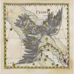
Cygnus.
Uncommon celestial print of Cygnus, published by Corbinianus Thomas in the Manuductio ad Astronomiam, Juxta modum Bayeri, Mathematici celeberrimi, concinnata, multis,…e...
Date: Frankfurt / Leipzig, c.1730

Chungguk-do
Chungguk-do [Map of China] taken from a Korean printed Ch’onha chido [Atlas of all under Heaven] which is a 19th century version of the traditional Korean atlas produce...
Date: Korea, ca. 1820
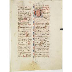
Leaf on vellum from an antiphonary.
A more than 600 years old antiphonary leaf, written in Besançon, in 1370. Musical notation on 4 bars, the staves are in red and the notes in black: numerous pen-flourish...
Date: Besançon, 1370

DELFT. Delphium urbs Hollandiae cultissima. . .
A bird's-eye view of the town of Delft. From the first Dutch translation of Guicciardini's description of the Netherlands. In this town-plan, three buildings, still domin...
Date: Amsterdam, 1612

EUROP, and the cheife Cities contayned therin described. . .
A good impression from an early edition of this famous and decorative "carte à figures"- map from the first world atlas produced by an Englishman - John Speed'...
Date: London, 1627 - 1676

Jerusalem.
Engraved by Bastiaan Stoopendaal from Juan Bautista Villapando's imaginary town-plan of Jerusalem. This bird's-eye view is surrounded by 12 scenes, views and portraits of...
Date: Amsterdam, 1682

Plan de la ville, cite universite et fauxbourgs de Paris comme il est jourddhuy. . .
Detailed town-plan of Paris.Top left and bottom right and left cartouches decorated with views of the top left, Notre Dame, Palace of Orleans, Sorbonne and Val de Grâce,...
Date: Paris, 1694
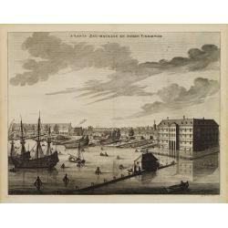
s'Lants Zee-Magazyn en Scheeps Timmer-werf.
Decorative view of the back yard formerly the V.O.C. warehouse and arsenal for the Admiralty of Amsterdam, now-a-days the Scheepvaartmuseum (Maritime Museum).The print is...
Date: Amsterdam, 1694
![Malines. [Mechelen]](/uploads/cache/13125-250x250.jpg)
Malines. [Mechelen]
A very RARE panoramic town view of Mechelen, including a numbered legend in the left lower corner.Published by the brothers Chéreau, active in Paris at rue st.Jacques au...
Date: Paris, c.1720
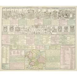
Kort Begryp van Duytsland, de drie Ryx Collegien in hunne Wapens en Zittingen. Kreits Verelingen en Aantekenigen door C. Specht't Utrectht.
Second state of this decorative table of family escutcheons, crests and coats of arms, for various German and Dutch princes and nobles of the 16th, 17th and 18th Centurie...
Date: Amsterdam, 1720
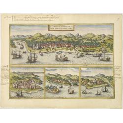
Calechut Celeberri mum Indiae Emporium/ Ormus/ Canonor, St.Georgii.
Four panoramic town-views on one sheet: The upper approximately two-thirds of this double-page sheet contains a fine panoramic view of Calicut which is on the west coast ...
Date: Cologne, 1580

Mastric ou Maëstricht, Ville du Brabant-Hollandois. . .
A very decorative and extremely rareof Maastricht, including a numbered key (1-23) in lower part. Engraved by Pierre-Alexandre Aveline. With "Fait par Aveline avec p...
Date: Paris, ca.1692
![Ulma Folio CXCI [With view of Ulm.]](/uploads/cache/29713-250x250.jpg)
Ulma Folio CXCI [With view of Ulm.]
Double-page panoramic view of Ulm.An imaginary view, however, is the earliest obtainable view of this period.Two pages from the richest illustrated Incunabel, the famou...
Date: Nuremberg, 12 July 1493
Prima Etas Mundi. IX (with Eve nursing Kain and Abel)
A very fine presentation of Eve nursing Kain and Abel. Adam is working (255x220 cm). VERSO a genealogy of Adam.Page from the richest illustrated Incunabel, the famous: Li...
Date: Nuremberg, 12 July 1493

Terra Promissions.
A beautifully executed and very rare map of the Promised Land, divided into the 12 Tribes. The shore line runs in north-southwesterly direction from Sidon as far as Pelus...
Date: Paris, c.1655
![Tercia Etas Mundi. Folium XXX. [The flight of Egypt, Moses receiving the Commandments, God's Angel, Balaam and his talking donkey. ]](/uploads/cache/29854-250x250.jpg)
Tercia Etas Mundi. Folium XXX. [The flight of Egypt, Moses receiving the Commandments, God's Angel, Balaam and his talking donkey. ]
On recto two nice woodblock prints (each 128x222mm.) of The flight of Egypt and Moses receiving the Commandments.VERSO : a woodblock print of God's Angel, Balaam and his ...
Date: Nuremberg, 12 July 1493
![[Title page to] Atlas mayor, o geographia Blaviana : Que contiene las cartas, y descripciones de Partes Orientales de Europa.](/uploads/cache/29952-250x250.jpg)
[Title page to] Atlas mayor, o geographia Blaviana : Que contiene las cartas, y descripciones de Partes Orientales de Europa.
Title page from a Spanish text edition of the Atlas Major. Ionic portico with celestial and terrestrial globes. To the left is Ptolemy with a sphere and a pair of compass...
Date: Amsterdam, c.1672

The Narta, or Sledge for burdens in Kamtschatka.
Webber's view of transport in Kamtchatka, Russia, showing the sledge dogs hooked up to the sledge, and their master on skis, taken from "Views in the South Seas"...
Date: London, Boydell and Co., 1808

Christophorus Clavius Bambergensis e societate iesu aetatis suae anno LXIX.
Rare portrait of Christopher Clavius or Clau (March 25, 1538 – February 12, 1612) was a German Jesuit mathematician and astronomer who was the main architect of the mod...
Date: Rome, 1606
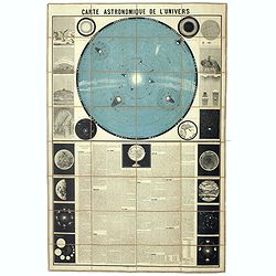
Carte Astronomique de L'Univers.
A large and decorative, informative chart illustrating and describing the Solar System, backed by the stars, printed in blue and black, surrounded by further 17 vignette ...
Date: Paris, 1875

De Texel Stroom .. vant Marsdiep./ Caarte van De Mase...
Two decorative charts on one sheet, one depicting Texel and the entrance of the Zuider Zee with an inset showing the north coast of West-Friesland, the other depicting th...
Date: Amsterdam, 1660

Tabula ducatus Limburch et comitatus Valckenburch. . .
The map describes the southern part of Limburg and reaches into Belgium (Liege, Verviers) and Germany. With two very decorative cartouches.
Date: Amsterdam, 1690

Prospectus Castelli Boxtel.
One of the earliest views of the Castle of Boxtel. Engraved by Henricus Cause. With a description in Latin, French and Dutch.
Date: Amsterdam, 1695

Prospectus veteris castelli Graviae.
One of the earliest views of the ancient Castle of Grave. Engraved by Casper Bouttats. With a description in Latin, French and Dutch.
Date: Amsterdam, 1695

Kasteel Croij.
Decorative lithography of the castle of Croij.
Date: Den Haag, 1880

Ruremunda Gelriae opp.
A bird's eye town-plan of the town of Roermond. From the first Dutch translation of Guicciardini's description of the Netherlands.
Date: Amsterdam, 1612
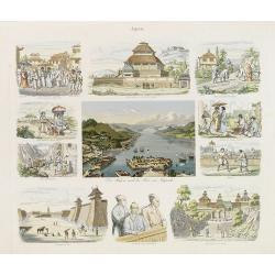
Der Hafen und die Bai von Nagasaki.
A fine composite sheet of engravings of sites and scenes in Japan, a central bird's-eye view showing Deshima and Nagasaki Bay with V.O.C. vessels. Due to Dutch presence ...
Date: Germany, 1850

Zelandia Comitatus.
Based on the map by Van Deventer. For the first time a road connection between Flushing, Middelburg and Arnemuiden is shown. Mercator pays much attention to the area of s...
Date: Amsterdam, 1630

't dorp Aalst.
Rare print of the old church of Aalst (near Eindhoven), from Vaderlandsche gezichten of afbeeldingen.. by J.Bulthuis, printed by H.Gartman in Amsterdam.
Date: Amsterdam, 1786 / 1792

Pascaert van Engelant Van t'Voorlandt tot aen Blakeney waer in te sien is de mont vande Teemse.
Two charts on one sheet. One decorative sea chart of the southeast coast of England with an inset of the Thames till London, embellished with two title cartouches, a ship...
Date: Amsterdam, 1666

Cust van Hollant Tussen de Maes ende Texel.
Uncommon chart of the coast of Holland, including the southern tip of Texel. East at the top. Two fine compass cards, soundings and a large Bree Veerthien offshore.Piete...
Date: Amsterdam, 1666
Illustriss et excellentiss D.Paulus Quirini divi Marci procurator.
Fine text page from Isolario Dell'Atlante Vento. with two copper engraved portraits printed within letter press. In top portrait of "Hieronymus Quirinus" (60x55...
Date: Venice, 1691
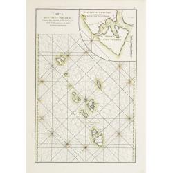
Carte des Isles Nicobar... (with) Plan particulier du Port compris entre les Isles Nacaveri, Souri, et Tricutte.
French chart of Isles of Nicobar in Gulf of Bengal near Birmanie and Sumatra. Prepared by Jacques-François L'Abbé Dicquemare (1733-1789). Latitude and longitude scales,...
Date: Paris, Brest, chez Demonville, 1775

Military map of the countries between Odessa & Perekop with the stations of the Russian forces.
Rare colored linen-backed map showing Russian troop positions and Odessa Batteries. On the inside of the cover a list of "Wyld's list of recent publications : seat o...
Date: London, ca. 1855

The town & harbour of Sevastopol with the batteries & approaches. . .
Rare colored linen backed map showing the harbour and town of Sevastopol, with soundings. In upper left corner a inset map (65x150mm) of the Black Sea. In bottom part a l...
Date: London, March 27th, 1854
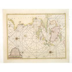
Paskaart van de Eijlanden Cheuxan Lowang en alle deselfs onderhoorige Eylande. . .
A rare and finely engraved and detailed chart of China's Zhejiang Province, including Ningbo, Zhoushan and Mount Putuo (Powto) and the mouth of the Yangtze Delta, just so...
Date: Amsterdam, 1753
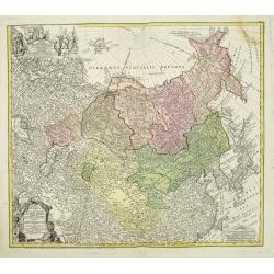
Imperii Russici et Tartariae Universae tam majoris Afiaticæ quam minoris et EuropæTabula.
The map is of interest for the use of East Sea, the sea between Korea and Japan, here called "Mere Orientale Minus".Decorative map covering Russia, Tibet, China...
Date: Nuremberg, 1739

Novissima Flandriae Comitatus tabula. . .
Rare issue of Theodorus Danckert's attractive map of eastern Belgium provinces, Flanders, with Brugge, Oostende, Gent, Mons, Antwerp, Cambray, etc..Decorative title carto...
Date: Amsterdam, 1700