Recently Listed Listings

Erfolgte Kapitulation zwischen dem General Bonaparte und den Gross Leister von Malta. Vor der Hauptstadt Walette zu Maltha, am 10 Juni 1798.
Copper engraving with three scenes and one portrait on one sheet. In upper a view of Bonaparte arriving at Valletta. Published in "Allgemeine Welt-Chronik oder neue ...
Date: Zittau, 1798-1800
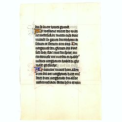
Manuscript leaf on vellum from a Dutch Book of Hours.
RECTO: Two 1-line capitals in red, blue or burnished gold with extensive penworkVERSO: One 1-line capitals in red, blue or burnished gold with extensive penwork.
Date: Flanders ca.1450
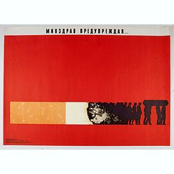
Ministry of health warned . . .
Uncommon Soviet propaganda poster against tobacco consumption.Read more about the Soviet propaganda poster. [+]
Date: Moscow, 1988

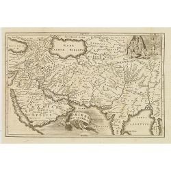
Etats du Grand-Seigneur en Asie, empire de Perse, pays des Usbecs, Arabie et Egypte.
Detailed map of the region bounded by the Black Sea, Georgia, the Caspian, Uzbekistan, The Indian Ocean, Saudi Arabia (here called \"Arabie Heureuse\"), Egypt a...
Date: Venise, 1778

Arabie.
Uncommon miniature map of the Arabian peninsula, from Pierre Duval's La Geographie Universeille dated 1676. Following his Cartes de géographie in 1657, Pierre Duval publ...
Date: Paris, 1676
Sexta Etas Mudi. / Simon Beatus .. / Folio CCLIIII.
A very fine presentation of the circumcision of Simon (192 x 223 mm.). RECTO: a falling star, a portrait of a King and an officer wearing armour. Page from the richest il...
Date: Nuremberg, 12 July 1493
Selling price: ????
Please login to see price!
Sold in 2026
![[Title page] Perspective die hooch-gheroemde conste..](/uploads/cache/25554-250x250.jpg)
[Title page] Perspective die hooch-gheroemde conste..
Title page from Perspective, Dat is, de hooch-gheroemde conste eens schijnende in oft door-siende ooghen-ghesichtespunt ... (&c.) by Hans, or Johannes Vredeman de Vri...
Date: Leiden, 1604

Save (the) world for us.
Uncommon Soviet propaganda poster. Text translates to : Save (the) world for us.Read more about the Soviet propaganda poster. [+]
Date: Moscow, 1989
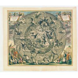
Hemisphaerii Borealis Coeli et Terrae Sphaeri Cascenographia.
A finely executed celestial chart of the Northern Sky, illustrating the constellations of the Northern Hemisphere superimposed over the Pacific Ocean, first published by ...
Date: Amsterdam, 1661
Selling price: ????
Please login to see price!
Sold in 2025
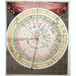
Discus Chronologicus Regum utriusque Siciliae et Ducum Princ
Chronological volvelle table showing the Sicilian rulers from the year 0 until 1730. COMPLETE with its volvelle. Each circle corresponds to a jurisdiction.
Date: Nuremberg, 1750
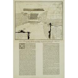
Plan De l'Action.. Auprès de Wynendale le 28 Sept. 1708.
A rare broadside sheet represents a conventional battle plan near the town of Torhout with the Castle Wynendale. The plan depicts the situation of 28 September 1708. Incl...
Date: Bruxelles, c.1708

Woman of Brabant.
Very fine view of a woman wearing the traditional dress of Brabant.
Date: London, 1817
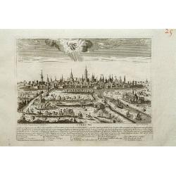
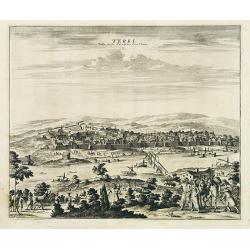
Utrecht.
A very RARE panoramic view of Utrecht, including a numbered legend in the lower part.Engraved by Jean Crepy (the father) who was active as an engraver and publisher at th...
Date: Paris, 1690-1720
![Flessingue Ville de l'Ile de Walcheren. [Vlissingen]](/uploads/cache/13105-250x250.jpg)
Flessingue Ville de l'Ile de Walcheren. [Vlissingen]
A very RARE panoramic view of the city of Vlissingen. The plate is numbered in red pencil in the upper right corner.Engraved by Jean Crepy (the father), who was active as...
Date: Paris, 1690-1720
![Madeburga [ Maagdenburg Folio CLXXX ]](/uploads/cache/12338-250x250.jpg)
Madeburga [ Maagdenburg Folio CLXXX ]
Double-page panoramic view of Magdeburg. A imaginary view, however the earliest obtainable view of this period.Two page from the richest illustrated Incunable, the famous...
Date: Nuremberg, 12 July 1493

Leaf on vellum from an antiphonary.
A very fine antiphonary leaf, written in Latin, probably Rome. RECTO: The staves are in red and the notes are in black.VERSO: The staves are in red and the notes are in b...
Date: Italy, 1480
![Sexta Etas Mundi. Ratisbonna. [Ratisbonne]](/uploads/cache/13549-250x250.jpg)
Sexta Etas Mundi. Ratisbonna. [Ratisbonne]
A very fine presentation of the city of Ratisbon, in Germany, centered on the cathedral (Dim. : 191 mm W : 525 mm).Overleaf a very nice view of Vienna, with two swans on ...
Date: Nuremberg, 12 July 1493

De Tesselstroom met de Gaten van Marsdiep./ De Mase met. . .
Three charts on one sheet depicting the entrances to the Zuiderzee between Holland, Texel and Vlieland. The entrances of the Maas with Rotterdam and in a small inset the ...
Date: Amsterdam, 1662

Transisalania vulgo Over-Yssel auct. N. ten Have. . .
Map of the central part of the Netherlands, prepared by N. ten Have with a decorative cartouche lower left.Joachim Ottens (1663 - 1719) and his sons Renier and Joshua wer...
Date: Amsterdam, ca. 1750
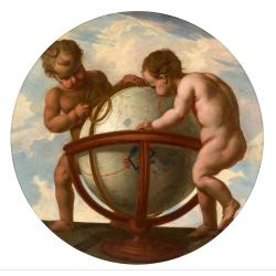
Allegory of geography.
Two putty studying a terrestrial globe, one of them holding a pair of dividers. The information on the globe is clearly imaginary but the two cartouches and ships are typ...
Date: Bruges, ca. 1700

Het Klooster ten Hage (Marienhage Eindhoven)
Very rare lithography of the ruin of the monastery of Ten Haghe in Eindhoven. Lithographed by M.Mouret, published in "oud-Nederland en de uit vroegere dagen overgebl...
Date: Nijmegen, 1837-1846

Peregrinationis Divi Pauli Typus corographicus. . .
A splendid map depicting the travels of Paulus. With two fine scenes in top. Showing the countries along the Mediterranean, including Cyprus and Italy. A first edition wi...
Date: Antwerp, 1595
Selling price: ????
Please login to see price!
Sold in 2026

A unique composite atlas with updated Porro maps.
Unique composite atlas containing in total 84 maps - 82 maps engraved by Girolamo Porro and heavenly reworked around 1686 and 2 newly engraved maps; Piccola Tartaria (Cr...
Date: Venice, 1686

Carte du Gouvernement de Provence, suivant les nouvelles observations...
Fine copper engraved and decorative map of the Provence region in the south of France. It includes the cities of Nimes, Viviers, Avignon, Aix and Nice. The pictorial cart...
Date: Amsterdam 1728
Terki, ville de la Circassie, dans l'Asie.
A very detailed panoramic view of Terki in the Caucasus, the capital of one of the most powerful Dagestani potentates of southeast Asia.Showing the Volga River.The town o...
Date: Leiden, c. 1719
![Kantong [The Dutch Folly Fort off Canton]](/uploads/cache/05714-250x250.jpg)
Kantong [The Dutch Folly Fort off Canton]
Charming 18th water color on paper depicting The Dutch "Folly Fort" off Canton. Probably made by a western artist visiting China.Forts were built in several pla...
Date: Canton?, c.1750

Franciae orientalis../ Monasteriensis et osnaburgensis..
From 'Theatrum Orbis Terrarum [Atlas of the Whole World]' published in Antwerp. French text on verso.The map of Frankenland is prepared by Sebastian Rotenhan (1478-1532) ...
Date: Antwerp, c.1574

(EUROPE).
The map of Europe has been identified as the work of Hieronimus Münzer (1437-1508), a Nuremberg physician who supplied the geographical contents of the chronicle. The Eu...
Date: Nuremberg, 1493

The Rubaiyat of Omar Khayyam (Edward Fitzgerald translation)
Edward FitzGerald, an outstanding writer who has done more than anyone to popularise English poetry. His best-known work, The Rubaiyat of Omar Khayyam (1859), began by be...
Date: England, ca. 1930

Corea and Japan.
A fine large-scale map of Japan and Korea showing an increasingly refined outline to the Japanese islands but still oversized Korean peninsula. The strait south of Korea,...
Date: Edinburgh, 1816

Nieuwe Kaart van de Westfaalse Kreits..
Isaac Tirion was born in Utrecht ca. 1705. He came to Amsterdam ca. 1725. Tirion published a number of important books, many of which are still in demand for their intere...
Date: Amsterdam, 1745

Biturigum.
A miniature map of the Berry. Fine cartouche in the upper left corner.First published in 1598 in his Caert-Thresoor, the plates were executed by the most famous engravers...
Date: Amsterdam/Frankfurt 1609

Carte de la Turquie, de l'Arabie et de la Perse..
Large map of the Near East, based upon earlier maps by De L'Isle. Shows also most part of the Mediterranean basin as well as north-eastern Africa. Relief shown pictoriall...
Date: Amsterdam c. 1745

Hydrograhica descriptio
This very rare chart is important as the first printed sea chart of the Mediterranean coast of Spain, Gibraltar, also depicting the northern coast of Marocco.Willem Bar...
Date: Amsterdam, W.Blaeu, 1612

Tabula Bergarum ad Zomam Stenbergae et novorum ibi operum.
The map gives an outline of the Scheldt from Bergen op Zoom to Antwerp, with all the ramparts built between 1622 and 1627.
Date: Amsterdam, 1647
![[Title page] Le Theatre du Monde ou Nouvel Atlas.](/uploads/cache/06812-250x250.jpg)
[Title page] Le Theatre du Monde ou Nouvel Atlas.
Architectural frontage with the title and imprint printed on paste-on slips.Parts of the item are heightened in gold. Read more about maps heightened in gold
Date: Amsterdam, 1640

Die Republic Holland oder die Verenigte Niederlande..
Charming map of the Netherlands, with inset maps of Novi Belgium area in America and Indonesia. With a fine cartouche.
Date: Leipzig, 1749
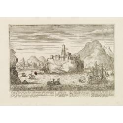
Ceuta Ville d'Afrique au D'estroit de Gibraltar.
A very RARE panoramic view of the city of Ceuta, including a numbered legend in both lower corners.Published by the brothers Chéreau, active in Paris at rue st.Jacques a...
Date: Paris c.1720

Carte du Katay, ou Empire de Kin : pour servir a l'Histoire de Jenghiz Khan, raportée dans l'Histoire generale des voyages, tirée de l'Angloise.
The map is of interest for the use of East Sea, the sea between Korea and Japan, here called "Mer de Corée".Fine map of Korea and China's Yellow Sea. Complete ...
Date: Paris, 1750
Selling price: ????
Please login to see price!
Sold in 2023

A ship's hour glass
The element common to celestial position-finding, the calculation of speed for dead reckoning and even everyday life at sea is the time: hence ways of determining and kee...
Date: ca. 1790
![Chambery / Turo / Coucy le Chateau. . . [5 prints]](/uploads/cache/14386-250x250.jpg)
Chambery / Turo / Coucy le Chateau. . . [5 prints]
A set of 5 prints. A nice view of Chambery: in Savoie; a charming view of Coucy le Chateau, engraved by Picquenot; a very fine plan of Tours, including a lettered key on ...
Date: Paris, 1580 -1750

(Lübeck) Lvbeca vrbs. imperialis libera. civitatvm. Wandalicarvm. . . .
Impressive, more than 3 meters wide panoramic town view after a woodblock engraving from Elias Diebel, initially made in 1552. Of this original woodblock, Bachmann mentio...
Date: Germany, c. 1855

Leaf from a French (Paris) book of hours.
Leaf from a French (Paris) book of hours, written in black ink, 16 lines of text. Recto: Text starts at Matins,the beginning of the hours to the holy Virgin "Ïncip...
Date: Paris ca. 1420

Carte Réduite Des Côtes Orientales De L' Amérique Septentrionale Contenant Partie du Nouveau Jersey.. Virginie.. Georgie..
Uncommon chart that extends from Delaware Bay and Philadelphia south through much of Georgia to Island Amelia and St. Johns River. Fleur-de-lis and rhumb lines fill the s...
Date: Paris, 1778

Kaart van de Gaspar Straaten volgens opnemingen van J.Stolze, D.Ross, enz.
Very large and rare chart centered on the strait between Bangka's southeastern seacoast and Belitung's western shores.Short front views of the coastal relief are shown in...
Date: Amsterdam 1843
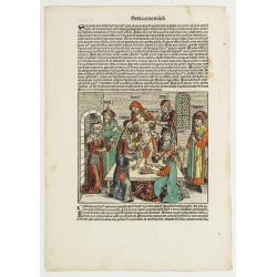
Sexta Etas Mudi. Symon Apostolus.. Folio CVII.
A very nice presentation of the martyr of Simon, sawn in half at Suanir, and Mathias stoned to death at Colchis in 80 AD. Overleaf, it shows the martyr of Matthew and Jud...
Date: Nuremberg, 12 July 1493
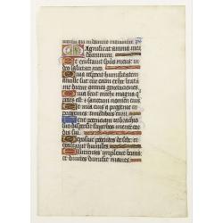
Leaf on vellum from a manuscript Book of Hours.
RECTO: One 2-lines initial decorated with flower in liquid gold on colored grounds and seven 1-line initials in liquid gold on colored grounds and six line-fillers in sam...
Date: France, ca.1530

The Crimea by James Wyld Geographer to the Queen & H.R.H. Prince Albert.
Fourth edition of this folding map of the Crimea. In upper right corner an inset map of the areas around the Black Sea; "The Town & Harbor of Sevastopol with the...
Date: London, 1855

Quinta Asie Tabvla.
A woodblock map of ancient Median and Persian lands in modern-day Iran is from Martin Waldseemüller's 1513 edition of Ptolemy, a landmark work that contributed to major ...
Date: Strasbourg, J. Schott, 1513

Nouvelle Mappa Monde.
State 2 of this fine double hemisphere world map, from an unusual perspective, with a "Mer de L'Ouest" or "Sea of the West". Paris is located at the c...
Date: Venice, 1776 - 1784
![Posesiones de America : Isla de Cuba. [together with] Isla de Cuba. . .](/uploads/cache/23458-250x250.jpg)
Posesiones de America : Isla de Cuba. [together with] Isla de Cuba. . .
Wall size sea chart and map of land areas showing all of Cuba, part of Florida Keys plus San Adios and Salvador Grande in the Bahamas.Minute topographical, political, and...
Date: Madrid, 1853 / 1851
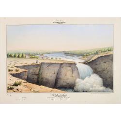
Southern - Concan.. - The falls of Gokank..
Hand colored lithography representing a view of the Gokak Falls, located on the Ghataprabha River. The Ghataprabha river in India is an important right-bank tributary of ...
Date: Paris, 1843
![[The creation of the world - First day]](/uploads/cache/24509-250x250.jpg)
[The creation of the world - First day]
Attractive page from the Nuremberg Chronicle, showing the creation of the world: the First Day, showing the celestial choir (God\'s creation of the angels) surrounding th...
Date: Nuremberg, 12 July 1493

Les jeunes voyageurs en Europe, ou description raisonnée des divers pays compris dans cette partie du monde.
The second edition of this fine travel companion is illustrated with 16 very decorative maps, each map surrounded by local products and specialties of the region. Include...
Date: Paris, Thiériot, 1827
Oriens, Persia, India etc.
Uncommon map of Persia, Armenia, Arabian Peninsular and part of India. Prepared by Christoph Cellarius (1638-1707). From Geographia Antiqua...
Date: Leipzig, Gledisch, 1732
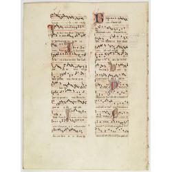
Leaf on vellum from an antiphonary.
A more than 600 years old antiphonary leaf, written in Besançon, in 1370. Musical notation on 4 bars, the staves are in red and the notes in black: numerous pen-flourish...
Date: France, 1370
![[2 maps] Partie Septentrionale.. Partie Meridionale du Royaume de Portugal..](/uploads/cache/25084-250x250.jpg)
[2 maps] Partie Septentrionale.. Partie Meridionale du Royaume de Portugal..
A detailed two sheet map of Portugal showing the roads, prepared by N.Bellin.Venetian edition of the map by Bellin, to whom Santini gives credit in the cartouche.From &qu...
Date: Venice, 1776 - 1784
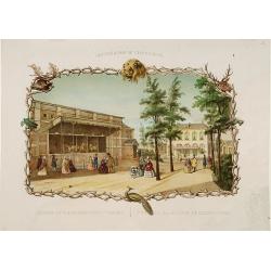
Rotterdamse Diergaarde. . .
Decorative view of the Zoo of Rotterdam. To the right is the house of the zoo's manager. Decorated with personages in typical dress watching lions.
Date: Amsterdam, 1860
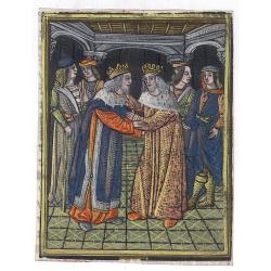
(Fragment of a text leaf from Universal Chronicle)
Fragment of a text leaf, showing a miniature depicting two Kings who are greeting each other surrounded by their knights. The metal cut has contemporary hand coloring and...
Date: Paris, c.1490-1500

Caerte der Noordt cufte van Engelandt, beginnende van Robinhodes baij tot Coket Eijlandt. . . .
A very early Dutch text edition of this detailed chart of the northern coast of England. The mileage cartouche has no Latin captures. West to the top.Decorated by a color...
Date: Leiden, Plantijn, 1585
![Morokoshi Meisho Zue [Illustrated Description of Famous Sites of China].](/uploads/cache/34118-250x250.jpg)
Morokoshi Meisho Zue [Illustrated Description of Famous Sites of China].
Published in Osaka, Kawachiya Genhichiro, et al. [8 book sellers], slightly later issue but apparently in Edo period, using all the same woodblocks of original first edit...
Date: Osaka, Edo, slightly later than Bunka 3, year of the tiger - 1806
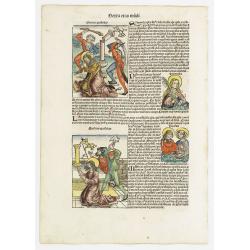
![Sexta Etas Mundi. Foliu CXXXV [Text page with S. Hieronymus, the patron of theological learning].](/uploads/cache/25763-250x250.jpg)
Sexta Etas Mundi. Foliu CXXXV [Text page with S. Hieronymus, the patron of theological learning].
Text page with woodcuts of the following saints: S. Hieronymus, the patron of theological learning (100x80mm.)VERSO is printed with text and images of Popes and Kings.Pag...
Date: Nuremberg, 12 July 1493
![[ First Separate Map of Michigan Territory ] Geographical, statistical, and historical map of Michigan territory.](/uploads/cache/25931-250x250.jpg)
[ First Separate Map of Michigan Territory ] Geographical, statistical, and historical map of Michigan territory.
The map illustrates Michigan Territory and the so-called "Indian Line" shortly after the Treaty of Chicago (1821), the third of three treaties with the Native A...
Date: Philadelphia, 1822
![[Crimea]. Carte de la Cromée.](/uploads/cache/25719-250x250.jpg)
[Crimea]. Carte de la Cromée.
Mapmaker, Captain Jan Hendrik van Kinsbergen (1735-1819). Published by H. Friesman in 1787. This map first appeared in 1776 and was the first Russian map of the newly ann...
Date: Amsterdam, H. Frieseman, 1787
![Otago Capo dell'Isola d'Amsterdam nel Mare Pacifico del Sud. / Otago Chef de l'Isle d'Amsterdam dans la Mer Pacifique du Sud. .. [Tongatapu, Tonga]](/uploads/cache/26090-250x250.jpg)
Otago Capo dell'Isola d'Amsterdam nel Mare Pacifico del Sud. / Otago Chef de l'Isle d'Amsterdam dans la Mer Pacifique du Sud. .. [Tongatapu, Tonga]
Otago was a native of the island of Tongatapu, Tonga. The island was first sighted by Europeans in 1643 by Abel Tasman, commanding two ships. “Tasman named the island &...
Date: Venice, Antonio Zatta, c.1790
![Coffre Sculpté des Habitants de la nouvelle Zélande. [Tome III Pl. 13.]](/uploads/cache/26092-250x250.jpg)
Coffre Sculpté des Habitants de la nouvelle Zélande. [Tome III Pl. 13.]
A carved chest of New Zealand, as a specimen of the carving of the country. Engraving drawn after John Frederick Miller (1759-1796). John Frederick Miller was an English ...
Date: Paris, 1773
![Hausse-col militaire des insulaires de la Mer du Sud. [Tome II Pl. 12.]](/uploads/cache/26095-250x250.jpg)
Hausse-col militaire des insulaires de la Mer du Sud. [Tome II Pl. 12.]
Maori warrior rise-collar. From the French edition of James Cook's first voyage entitled Relation des voyages entrepris par ordre de sa Majesté Britannique actuellement ...
Date: Paris, 1773
![Instruments des insulaires de la Mer du Sud. [Tome II Pl. 15.]](/uploads/cache/26097-250x250.jpg)
Instruments des insulaires de la Mer du Sud. [Tome II Pl. 15.]
Divers tools. From the French edition of James Cook's first voyage entitled Relation des voyages entrepris par ordre de sa Majesté Britannique actuellement régnante pou...
Date: Paris, 1773
![Emouchoir des Otahitiens avec ses manches. [Tome II Pl. 13.]](/uploads/cache/26098-250x250.jpg)
Emouchoir des Otahitiens avec ses manches. [Tome II Pl. 13.]
The print depicts three ceremonial fly-whisks from Tahiti. Each object features ornate carved handles with anthropomorphic figures and long flowing fibers, accompanied by...
Date: Paris, 1773
![Vue de l'Isle d'Otahiti et de plusieurs Pirogues. [Tome II Pl. 11.]](/uploads/cache/26102-250x250.jpg)
Vue de l'Isle d'Otahiti et de plusieurs Pirogues. [Tome II Pl. 11.]
View of the Island of Tahiti and dugouts. From the French edition of James Cook's first voyage entitled Relation des voyages entrepris par ordre de sa Majesté Britanniqu...
Date: Paris, 1773
![Vue de l'Isle d'Ulietéa avec une double Pirogue et un hangar où les Insulaires retirent leurs bâtiments de mer. [Tome III Pl. 5.]](/uploads/cache/26106-250x250.jpg)
Vue de l'Isle d'Ulietéa avec une double Pirogue et un hangar où les Insulaires retirent leurs bâtiments de mer. [Tome III Pl. 5.]
A view on the Island of Ulietea, French Polynesia, of a dugout boat house and a beautifully engraved pirogue at sea. From the French edition of James Cook's first voyage ...
Date: Paris, 1773
![Vue de l'Isle d'Huaheine avec La Maison de Dieu, et un petit Autel couvert d'offrandes. [Tome III Pl. 4.]](/uploads/cache/26108-250x250.jpg)
Vue de l'Isle d'Huaheine avec La Maison de Dieu, et un petit Autel couvert d'offrandes. [Tome III Pl. 4.]
A view of the Island of Huaheine, Tahiti, a beautiful tropical Owharra tree in the foreground and a depiction of the House of God with its offertory. From the French edit...
Date: Paris, 1773
![Village fortifié bâti sur un Rocher troué de la Nouvelle Zélande. [Tome III Pl. 10.]](/uploads/cache/26110-250x250.jpg)
Village fortifié bâti sur un Rocher troué de la Nouvelle Zélande. [Tome III Pl. 10.]
A view of a village fortified on a hollow rock in New Zealand. Engraved by François Godefroi. From the French edition of James Cook's first voyage entitled Relation des ...
Date: Paris, 1774
![Cession de l'Isle d'Ohahiti au Capitaine Wallis par la Reine Obéréa. [Tome II Pl. 2.]](/uploads/cache/26111-250x250.jpg)
Cession de l'Isle d'Ohahiti au Capitaine Wallis par la Reine Obéréa. [Tome II Pl. 2.]
Queen Oberea's transfer ceremony to Captain Wallis on Tahiti.Engraved by François Godefroi. From the French edition of James Cook's first voyage entitled Relation des vo...
Date: Paris, 1774
![Vue d'un Rocher troué de la Nouvelle Zélande. [Tome III Pl. 8.]](/uploads/cache/26112-250x250.jpg)
Vue d'un Rocher troué de la Nouvelle Zélande. [Tome III Pl. 8.]
A view of a New Zealand landscape and seascape through a hollow rock. Engraved by Demouchy. From the French edition of James Cook's first voyage entitled Relation des voy...
Date: Paris, 1773
![Manière dont on expose les morts à Otahiti. [Tome II Pl. 16.]](/uploads/cache/26113-250x250.jpg)
Manière dont on expose les morts à Otahiti. [Tome II Pl. 16.]
A view of a Tahitian funeral home in a beautiful landscape. Engraved by Demouchy. From the French edition of James Cook's first voyage entitled Relation des voyages entre...
Date: Paris, 1773
![[Papua New Guinea Inhabitants ].](/uploads/cache/26364-250x250.jpg)
[Papua New Guinea Inhabitants ].
Aquatint depicts three men in a pirogue engraved by Fumagalli. Plate N° 75. From Giulio Ferrario's work Le Costume Ancien et Moderne ou Histoire du gouvernement, de la m...
Date: Milan, 1827
![[The Admiralty Islands and New Britain inhabitants fishing. Papua New Guinea ].](/uploads/cache/26365-250x250.jpg)
[The Admiralty Islands and New Britain inhabitants fishing. Papua New Guinea ].
Aquatint depicting fishermen in dugouts engraved by A. Biasioli. Plate N° 14. From Giulio Ferrario's work Le Costume Ancien et Moderne ou Histoire du gouvernement, de la...
Date: Milan, 1827
![[New Caledonians ].](/uploads/cache/26367-250x250.jpg)
[New Caledonians ].
Aquatint depicting New Caledonians engraved by Biasioli. Plate N° 71. From Giulio Ferrario's work Le Costume Ancien et Moderne ou Histoire du gouvernement, de la milice,...
Date: Milan, 1827
![[Pirogues in the bay of the voyage of the Resolution. The Marquesas Islands ].](/uploads/cache/26373-250x250.jpg)
[Pirogues in the bay of the voyage of the Resolution. The Marquesas Islands ].
Aquatint depicting men in pirogues in the Bay of the Resolution from the Marquesas Islands engraved by Biasioli. Plate N° 91. From Giulio Ferrario's work Le Costume Anci...
Date: Milan, 1827