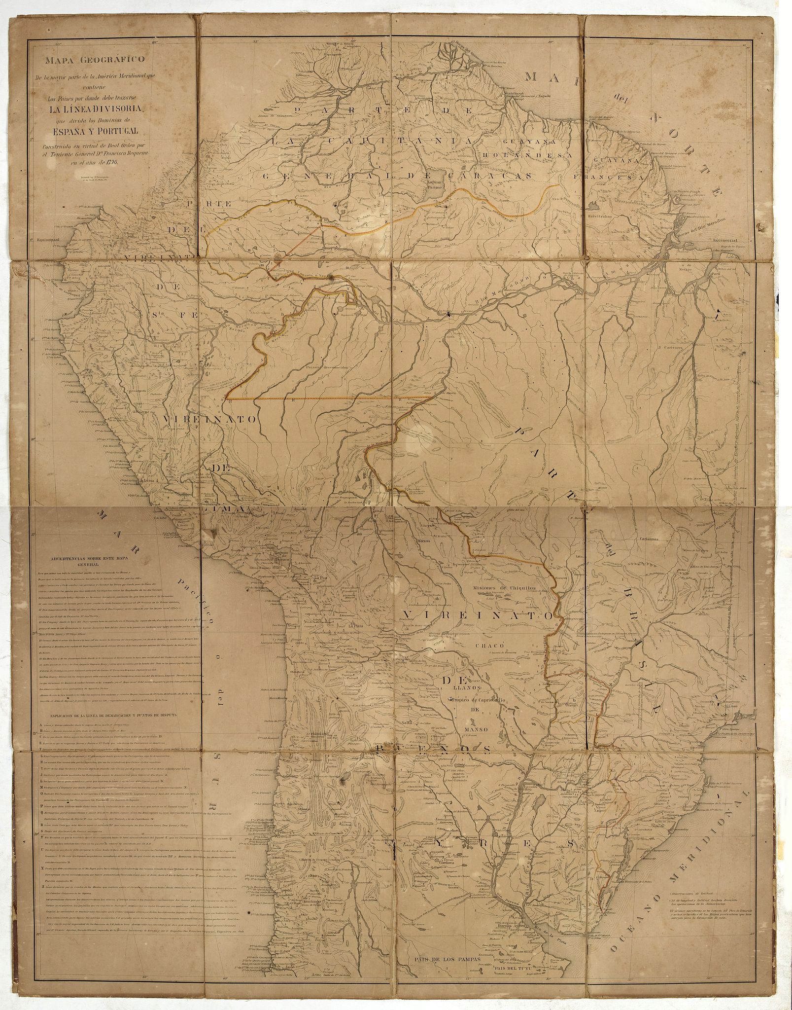
Mapa geogra´fico de la mayor parte de la Ame´rica Meridional que contiene los paises por donde debe trazarse la li´nia divisoria que divida los dominios de Espan~a y Portugal. . . |
||||||||||||||||||||
|
||||||||||||||||||||
|
|
||||||||||||||||||||
$3000 / ≈ €2623This item is available for immediate sale! Questions before Buying ?
We are happy to answer your questions.
3000.00
|
My Collection +
Add this or any of your favorite items in one place. If you want to save the items permanently, you have to sign in or create an account first. |
|||||||||||||||||||
Description
Rare first edition of the map drawn by Francisco Requena (1743-1824) after his expedition to the Amazon in order to delineate the boundary between the Spanish and Portuguese possessions in South America. The map covers most of South America and highlights the newly established Line of Demarcation. It is supplemented with "Advertencias sobre esta mapa general" and "Esplicacio´n de la linea de demarcacio´n y puntos de disputa" – a list of twenty border questions still to be resolved.
The map was drawn in 1796 to illustrate Requena’s official report “Memoria Histórica de las Demarcaciones de Límites en América entre los Dominios de España y Portugal”. None of the documents were published by the Spanish authorities at the time. “Requena’s maps proved of value in post independence border disputes.
In 1876 the Venezuelan government ordered the printing of Requena’s ‘Memoria Histórica’ and an associated map ‘Parte de los virreynatos’ to be used as documentary support for the arbitration of Venezuela’s border with Colombia. About the same time, F. Bourquin, a contract printer in Philadelphia, made a lithographic printing of the ‘Mapa Geográfico’” (Layland, M. “A Land that is uncultivated, insane, impassible and largely unknown…”, p. 49).
The map was “drawn to indicate the boundaries between the Spanish and Portuguese territories in accordance with the Treaty of San Ildefonso of 1777.
Francisco Requena arrived in America in 1764, having accepted a commission in the Spanish Americas in order to obtain promotion. He mapped the cities of Panama and Cartagena and was persuaded by the Viceroy, Mesia de la Cerda, to remain in America to continue his cartographic work, being asked to make a general map of the whole of the province of Guayaquil. After the Treaty of San Ildefonso, he was commissioned to establish the boundaries between the Spanish and Portuguese territories from the mouth of the Riber Yavari to the Rio Negro. The expedition was fraught with difficulties, the Spanish having little co-operation from the Portuguese. He systematically sent regular reports and letters to the Viceroy recording his movements and the situation with relation to the Portuguese.
In 1783 Requena was kept waiting at Ega (Teffe), unable to achieve his objective to define the boundary line between the two colonial powers, and to obtain a joint statement with the Portuguese. While awaiting the outcome of negotiations he took advantage of his enforced idleness to examine his manuscript notes and draw a map of the territory. This he sent to the Viceroy on 28 April 1783 (the map is dated 1 April 1783) having first to request a special pass from the Portuguese for his second in command to travel to Quito, which they refused to grant. At the end of 1790 he took up his duties as govenor of Mainas, and in 1794 left for Spain, later becoming Minister of the Council of the Indies” (Sotheby’s)
Complete title : Mapa geogra´fico de la mayor parte de la Ame´rica Meridional que contiene los paises por donde debe trazarse la li´nia divisoria que divida los dominios de Espan~a y Portugal : construido en virtud de real o´rden por el teniente general Dn. Francisco Requena en el ano de 1796.

Reference: Adonias, I. A Cartografia da Região Amazônica. Vol. 1., p. 323-326.
FAQ - Guarantee - Shipping
Buying in the BuyNow Gallery
This item is available for immediate purchase when a "Add to Cart" or "Inquire Now" button is shown.
Items are sold in the EU margin scheme
Payments are accepted in Euros or US Dollars.
Authenticity Guarantee
 We provide professional descriptions, condition report (based on 45 years experience in the map business)
Paulus Swaen warrants the authenticity of our items and a certificate of authenticity is provided for each acquired lot.
Condition and Coloring
We indicate the condition of each item and use our unnique HiBCoR grading system in which four key items determine a map's value: Historical Importance, Beauty, Condition/Coloring and Rarity.
Color Key
We offer many maps in their original black and white condition. We do not systematically color-up maps to make them more sellable to the general public or buyer.
Copper engraved or wood block maps are always hand colored. Maps were initially colored for aesthetic reasons and to improve readability. Nowadays, it is becoming a challenge to find maps in their original colors and are therefor more valuable.
We use the following color keys in our catalog:
Original colors; mean that the colors have been applied around the time the map was issued.
Original o/l colors; means the map has only the borders colored at the time of publication.
Colored; If the colors are applied recently or at the end of the 20th century.
Read more about coloring of maps [+]
Shipping fee
A flat shipping fee of $ 30 is added to each shipment by DHL within Europe and North America. This covers : International Priority shipping, Packing and Insurance (up to the invoice amount).
Shipments to Asia are $ 40 and rest of the world $50
We charge only one shipping fee when you have been successful on multiple items or when you want to combine gallery and auction purchases.
Read more about invoicing and shipping
FAQ
Please have a look for more information about buying in the BuyNow gallery
Many answers are likely to find in the general help section.
My Collection+
![]()
With My Collection+ you can collect all your favorite items in one place. It is free, and anyone can create his or her virtual collection.
Unless you are logged in, the item is only saved for this session. You have to be registed and logged-in if you want to save this item permanently to My Collection+.
Read More[+]
Register here, it is free and you do not need a credit card.
Add this item to
My Collection+
or click the following link to see My Collection+.
| Digital Image Download | |
|
Paulus Swaen maintains an archive of most of our high-resolution rare maps, prints, posters and medieval manuscript scans. We make them freely available for download and study. Read more about free image download |
Click the image for a free small image download. |
In accordance with the EU Consumer Rights Directive and habitually reside in the European Union you have the right to cancel the contract for the purchase of a lot, without giving any reason.
The cancellation period will expire 14 calendar days from the day after the date on which you or a third party (other than the carrier and indicated by you) acquires, physical possession of the lot. To exercise the right to cancel you must inform Paulus Swaen Inc, of your decision to cancel this contract by a clear statement (e.g. a letter sent by post, or e-mail.
To meet the cancellation deadline, it is sufficient for you to send your communication concerning your exercise of the right to cancel before the cancellation period has expired.
