Recently Listed Listings in America > North America

America settentrionale. . .
Rare map of North America drawn directly from the work of Nicholas De Fer and N. Sanson's famous map of 1650. The map is engraved by Antonius Donzel Gallus.With open Grea...
Date: Napels, 1766

L'Amerique Septentrionale.
Very rare map, from "Metaphaste Barbao, Descriptio Indiae Occidentalis et America Nova" published by Henrico Verdussen.The map is a copy of Guillaume de L'Isle'...
Date: Antwerp, 1702

P.les de Virginie.
Attractive copper engraving, depicting a couple of native people of Florida.From the French text edition of Description d'Univers, 1683. by Allain Manneson Mallet (1630-1...
Date: Paris, 1683

Nova Virginia Tabula.
A beautifully engraved map, derived from the highly influential map by Captain John Smith in 1612, showing Chesapeake Bay and the surrounding area. The decoration of this...
Date: Amsterdam, J.Meurs, 1671

Missions et Résidences dans la Partie Septentrionale de l'Amérique Contenant 50 Jésuites.
Very rare missionary map of North America from "Atlas Universel indiquant les établissemens des Jésuites: avec la manière dont ils divisent la terre, suivi desév...
Date: Paris, Ambroise Dupont , 1826

Carte de la Nouvelle France, ou se voit le cours des Grandes Rivieres de S. Laurens & de Mississipi..
Derived from de Fer's 1718 map, from west of the Mississippi it contains a mass of inland detail with notes and vignettes of the indigenous peoples and fauna of North Ame...
Date: Amsterdam, 1720
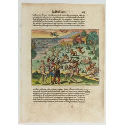
![[The French left in Fort Charles suffer the scarcity of provisions. (Virginia]](/uploads/cache/48529-250x250.jpg)
[The French left in Fort Charles suffer the scarcity of provisions. (Virginia]
An Indian town visited by the French of Charlesfort in search for food. After a drawing by LeMoyne. Charlesfort-Santa Elena is on what is now Parris Island, South Carolin...
Date: Frankfurt, 1594
Cacodemon attacking the savages.
Cacodemon ("evil spirit") attacking the savages. Read more about "Les Grand Voyages" by Theodore De Bry [+]
Date: Frankfurt, 1594
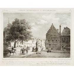
View in Albany-House of the first Dutch Governors.
Decorative print after Jacques Milbert, and lithographed by Tierpenne and the figures by Victor Adam.From Amérique Septentrionale. Printed by de Bove and Noöl ainé &am...
Date: Paris, 1829
Ride the Roads to Romance along the Golden Coast and thru the Sunshine Empire of Southern California.
Published in 1950 by the Roads to Romance Association to promote tourism in California This striking touring map of Southern California was published in 1950 by the Ro...
Date: California, 1950

Dutton Map of the Grand Canyon, Arizona (in 4 joined sheets)
An important 1882 map of the Grand Canyon, Arizona, published in "Atlas To Accompany The Monograph On The Tertiary History Of The Grand Canon District By Capt. Clare...
Date: Julius Bien and Co., 1882

Mappa Geographica provinciae Nova Ebboraci ab Anglis NEW-YORK dictae. . .
During the Revolution, this map afforded British commanders an excellent overview of areas that would be crucial in the early years of the war, particularly the Hudson Va...
Date: Nuremberg, 1778

ETATS-UNIS DE L'AMÉRIQUE SEPTENTRIONALE Avec LES ISLES ROYALE, DE TERRE NEUVE, DE S.T JEAN, L'ACADIE, &c. 1785. Supplement a l'Atlas de M. Robert de Vaugondy a Paris Ches Boudet Ingenieur du Roi.
A map of the eastern United States with "Supplément à l'atlas de M. Robert de Vaugondy à Paris chez Boudet Imprimeur du Roi", in place of the attribution to ...
Date: Paris, 1785
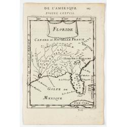
Floride.
A charming map of Florida, also showing Cuba, Golf of Mexico & St Augustine.Title in curtain draped at top. French text on verso.From the original 1683 text edition o...
Date: Paris, 1683

A new & accurate map of Louisiana, with part of Florida. . .
An English view of North America compiled from available French maps, especially those of Bellin used in Charlevoix's History of New France. English cartographers had lit...
Date: London, 1744
![Amerique Septentrionale divisée en ses principales parties. . .1685. [California as an Island]](/uploads/cache/60628-250x250.jpg)
Amerique Septentrionale divisée en ses principales parties. . .1685. [California as an Island]
Engraved by Cordier. Spectacular example of Jaillot's map of North America, showing California as an Island, based upon Sanson's landmark map of 1656. This map shows the ...
Date: Paris, 1685

Map of Pensylvania and New Jersey by H.S. Tanner.
First edition of this rare and important map of Pennsylvania and New Jersey by H.S. Tanner and published in his "New American Atlas" from 1823. Includes roads, ...
Date: Philadelphia, Henry Tanner, 1823
![Etats-Unis de L'Amerique Septentrionale. [Two sheets in manuscript ]](/uploads/cache/03972-250x250.jpg)
Etats-Unis de L'Amerique Septentrionale. [Two sheets in manuscript ]
Two sheets giving detailed information in French about the population in 1810, principal cities, products of industry and commerce, the financial situation for 1818, etc....
Date: France, ca. 1819
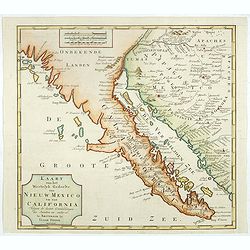
Kaart van het Westelyk Gedeelte van Nieuw Mexico en van California. . . MDCCLXV ..
A detailed map of the Baja California and Sonora, bounded on the north by the Colorado and Gila Rivers and approximately Mozatlan in the south, thus including parts of mo...
Date: Amsterdam, 1765
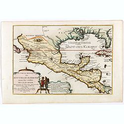
Le vieux Mexique ou nouvelle Espagne. . .
Attractive map covering the Gulf of Mexico through Central America also including parts of Cuba and Jamaica. It extends through Mexico to show the southern tip of Baja Ca...
Date: Paris, 1705

A Hysterical Map of the Yellowstone Park. . .
A funny 1936 pictorial map of Yellowstone Park, that was 'hatched and scratched' by the American printer and humourist Jolly Elmer Lindgren. This wonderful map covers the...
Date: Spokane, 1936

Forest scene on the Tobihanna Alleghany Mountains.
Original aquatint engraving for Travels in the Interior of North America between 1832-34 . Engraved by L.Weber. The finest work on American Indian life and the American F...
Date: London/Paris/Coblenz, 1839

Guaranty Trust Company of New York. Emprunt national 6%.n Souscrivez.
Very decorative propaganda poster with design by Mark All of Paris for "Guaranty Trust Company of New York", a JPMorgan Chase predecessor in order to promote th...
Date: Paris, 1918

Avantures du Sr. C. Le Beau, avocat en parlement ou Voyage curieux et nouveau parmi les Sauvages de l'Amérique Septentrionale. Dans lequel on trouvera une Description du Canada… Ouvrage enrichi d'une Carte et des figures necessaires.
A description of Huron, Iroquois, and Algonquin customs, written in charming style and based, the Author claims, on observations made on a trip to America in 1729." ...
Date: Amsterdam, 1738
Waschinga Sahba's Grab.. (Wakonda Creek.)
Original aquatint engraving for Travels in the Interior of North America between 1832-34 . Engraved by Ch. Vogel. The finest work on American Indian life and the American...
Date: London/ Paris/ Coblenz, 1839

Connecticut and Parts adjacent at Amsterdam. .
A nice example of this early map of the state of Connecticut with part of Rhode Island to the east, Long Island to the south, and New York to the east. Rivers, roads, t...
Date: Amsterdam, 1780

Carolinae Floridae nec non Insularum Bahamensium cum partibus adjacentibus delinatio ad Exemplar Londinense in lucem edita . . . Ao. 1755.
The German edition of this map of Carolina, Florida, and the Bahama Islands in full original colors. Published in Seligmann's "Sammlung verschiedener auslaendischer ...
Date: Nuremberg, 1755

Cunard Cherbourg-New York.
Original vintage Cunard luxury cruise liner travel poster advertising Cunard Europe to all America fastest ocean service in the world. Stunning design featuring two color...
Date: England, ca. 1930

Carte des Possessions Françoises et Angloises dans le Canada, et partie de la Louisiane.
First state of this separately published map of the European Colonies in the New World east of the Mississippi River. This map was published in 1756 to provide informatio...
Date: Paris, 1756

French Line CGT Poster.
French Line CGT Poster showing the Normandie cruise ship travelling from Southampton to New York, advertising an express luxury service on both the Ile de France and the ...
Date: England, ca. 1936
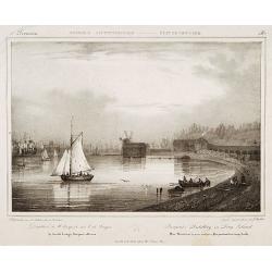
Pierpont's distillery on Long Island.
Milbert's topographical prints are an eyewitness record of life in America in the early 19th centuryDecorative print after Jacques Milbert, and lithographed by Sabatier a...
Date: Paris, 1829

Sabena (USA - NYC).
Sabena Belgian World Airlines poster showing the skyline of New York in abstract style. Published by Rali Brisart in Belgium.La Sabena, acronym for Societé Anonyme Belg...
Date: Brussels, ca. 1970

Novi Belgii novae que Angliae nec non partis Virginiae..
With the arrival of Dutch and other European colonists, the landscape of New Netherland changed dramatically. The third state, with Fort Kassimier and Philadelphia, and ...
Date: Amsterdam, 1684
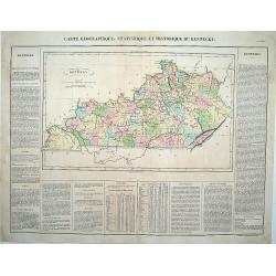
Carte Géographique .. Kentucky.
Detailed map of Kentucky. From J.A. Buchon, "Atlas Gégraphique Statistique, historique et chronologique des deux Ameriques et des isles adjacentes; traduit de l'atl...
Date: Paris, 1825

Bison Iubatus.
Etching of a bison by Leendert Brasser (1727 - 1793) after a painting of the Dutch artist Gerrit van den Heuvel.An early portrait of a bison, etched by Leendert Brasser (...
Date: Rotterdam, 1766-1793

Virginie, Grande Region l'Amerique Septentrionale...
Pierre van der Aa used the old copper plate of Meurs and re-did the engraving, changed the large pictorial cartouche, a new scale of German and French leagues is provided...
Date: Amsterdam, 1729

Carte de LA LOUISIANE et des PAYS VOISINS Dédiée a M. Rouillé Dediee a M. Rouille Secretairr 'd Etat ayant le Departement de la Marine... 1750
North America from the eastern seaboard to the Rocky Mountains. Based on Delisle's map of 1718 with additions from notes compiled by the Jesuit priest, explorer and histo...
Date: Paris, 1750
![Amerique Septentrionale divisée en ses principales parties. . .1692. [California as an Island]](/uploads/cache/27961-250x250.jpg)
Amerique Septentrionale divisée en ses principales parties. . .1692. [California as an Island]
A very good impression of Jaillot's large map of North America, showing California as an Island, based upon Sanson's landmark map of 1656. A first state.The map shows the...
Date: Amsterdam, c.1692

Plan du Port de St Augustin dans la Floride.
This chart shows a plan of the Port of St. Augustine in Florida.The only issue of this version of Bellin's map, slightly larger than the common version. Depths shown by s...
Date: Paris, 1764

Carte qui contient..Iles & Terres..L'Amerique..Jamaique..
Eight maps on one sheet. From Chatelain's Atlas Historique et Méthodique . Including maps of Bermuda, Jamaica, New England with Long Island, Carolina, Chesapeake and Del...
Date: Amsterdam 1728

Map of Louisiana from D'Anville's Atlas.
This map presents a highly detailed treatment of the region from Cabo Del Norte to the Apalachiola River, centered on the mouth of the Mississippi and extending inland to...
Date: London, 1788

Carte du Mexique et des Etats Unis d'Amérique...
A later edition of De l'Isle's foundation map of 1703, is widely regarded as one of the most influential maps in the history of American Cartography. This updated version...
Date: Paris, 1783

A Map of the British Empire in AMERICA with the French, Spanish and Hollandish Settlements Adjacent Thereto. by Henry Popple. / Nouvelle Carte Particuliere de L'Amerique . . .
The four sheet Dutch edition of Popple's monumental map of North America, in mint condition. Encompassing the West Indies, Florida, Louisiana, Texas and Central America.T...
Date: Amsterdam, ca. 1737

Coast to Coast.
A game board that features a map of the U.S. with a built-in spinner. Players travel a circular track around the map visiting landmarks as they go. A fun way to learn geo...
Date: New York, ca. 1950

San Diego Bay. (Chart 5107)
Nautical chart of San Diego Bay of 1945. Printed in black, yellow and purple the "Seaward limit defensive sea area". The water area within the indicated limits ...
Date: Washington, 1945

Nader prolongatie van het Octroy voor de Westindische Compagnie voor den tyd van nog dertig jaaren. . .
A proclamation by the Dutch States General, dated 1761, extending the charter of the Dutch West India Company for another thirty years. Like the 1730 proclamation, it has...
Date: Amsterdam, 1761

A new map of the English Empire in America. . .
This fine English map of eastern North America including Canada engraved by John Harris and first published by Robert Morden. John Senex acquired and made minor alteratio...
Date: London, 1720

Nova Virginiae Tabula.
A fine example of Blaeu's map of Virginia and the Chesapeake region is based on the first state of Smith's map, 1612, and is slightly larger and more expertly engraved.Th...
Date: Amsterdam, 1640
![[Soil map] Virginia-Maryland-West Virginia, Leesburg sheet.](/uploads/cache/23257-250x250.jpg)
[Soil map] Virginia-Maryland-West Virginia, Leesburg sheet.
Early color lithographed soil map by Julius Bien & Co. in New York for Department of Agriculture. Legends at side give detail on soil type, etc. They also include int...
Date: New York, 1903

A-Na-Cam-E-Gish-Ca. A Chippeway Chief.
Half-length portrait of Anacamegishca, bare-chested, wearing a blanket and a peace medal. A-Na-Cam-E-Gish-Ca (1785-1862) - was a Chippewa (Ojibwe) Native American chief. ...
Date: Philadelphia, 1837

Ca-Ta-He-Cas-Sa-Black Hoof. Principal Chief of the Shawanoes.
Half-length portrait of Catahecassa wearing a dark colored jacked, grey vest, white shirt, and grey head scarf. A wonderful hand colored lithograph of Ca-Ta-He-Cas-Sa-Bl...
Date: Philadelphia, 1837

Major Ridge. A Cherokee Chief.
Head and shoulders portrait of Major Ridge,(1771-1839) wearing a blue jacket, gold or yellow vest, white shirt, and black cravat. A Cherokee Chief, who as a Cherokee lead...
Date: Philadelphia, 1837

Plan of Yonkers Town of Yonkers Westchester Co. N.Y. . . .
Fine lithographed map of Yonkers, New York. The map provides the names of specific homeowners, as well as information about the occupations and physical locations of the ...
Date: New York, 1867

Plan of the Borough of New Rochelle, Westchester Co. N.Y.
Fine lithographed map of the plan of the Borough of New Rochelle. The map provides the names of specific homeowners, as well as information about the occupations and phys...
Date: New York, 1867

Plan of the Beekmanton Tarryntown and Ivring. Westchester Co. N.Y.
Fine lithographed map of the plan of the Beekmantown, Tarrytown, and Irving, New York. The map provides the names of specific homeowners, as well as information about the...
Date: New York, 1867

New Jersey entworfen von D.F. Sotzmann. Hamburg bey Carl Ernst Bohn 1796 . . . NO.VIII
Extremely rare map of New Hampshire prepared by Daniel Friedrich Sotzmann for Christopher Ebeling's "Erdbeschreibung von Amerika", a project ended after only te...
Date: Hamburg, Carl Ernst Bohn, 1797

New Yok entworfen von D.F. Sotzmann. Hamburg bey Carl Ernst Bohn 1799 . . . NO.VII
An extremely rare map of New York prepared by Daniel Friedrich Sotzmann for Christopher Ebeling's "Erdbeschreibung von Amerika", a project ended after only ten ...
Date: Hamburg, Carl Ernst Bohn, 1799

Rhode Island entworfen von D.F. Sotzmann. Hamburg bey Carl Ernst Bohn 1798 . . . NO.V
Extremely rare map of Rhode Island prepared by Daniel Friedrich Sotzmann for Christopher Ebeling's "Erdbeschreibung von Amerika", a project ended after only ten...
Date: Hamburg, Carl Ernst Bohn, 1797

A plan of the City and Environs of Philadelphia. . .
The Lotter edition of Scull & Heap's seminal Philadelphia map, which map was first issued in 1752.Holmes' grid plan for the city is shown, situated between the rivers...
Date: Augsburg, 1777

United States At-A-Glance.
A clever device for demonstrating the statistics of each state, the Area, Population, Highest Elevation, Principal River, Capital, railroad Mileage, Date Entered Union, P...
Date: New York / London: International At-A-Glance Chart Co. 1931

20 small lithographed views of Washington DC and Georgetown.
20 small lithographed town-views of Washington DC and Georgetown, cut out from a larger sheet. Showing the East Front of the Capitol, Treasury, Smithsonian Institute, Pre...
Date: Casimir Bohn, Washington, D.C.: 1849

Kiepert's Physikalische Wandkarten. VI. Nord-America.
Large folding school wall map of North and Central America printed in chromo-lithography. Published by Dieter Reimer and printed by Leopold Kraatz in Berlin. Three inset...
Date: Berlin, Dieter Reimer, 1864

Poli Arctici, et circumiacentium terrarum descriptio novissima. . .
A re-issue of the Hondius' plate. A particularly decorative map of the North Pole with Iceland. Several Dutch names in Labrador. The toponymy in Canada reflects the conti...
Date: Amsterdam, 1660

New York Ferry Boat. (Bac à vapeur de New York).
A very decorative print showing the New York Ferry Boat "Fulton," published by Currier & Ives. The Ferry boat "Fulton" sails to the right. A singl...
Date: New York, ca. 1875

La Florida/ Peruviae Auriferae regionis Typus/ Guastecan.
The Chaves map of Florida is a prime example of an explorer's map since it records the recent discoveries of Cabeza de Vaca, De Soto, and Moscoso. The map revealed little...
Date: Antwerp, 1592

Ilse Paese de' Selvaggi.. Lago Superiore. (Florida and the Bahamas)
Antonio Zatta published an Italian version of the John Mitchell map in twelve sheet. This sheet depicts Lake Superior in the Bellin version, as it appeared on the Mitchel...
Date: Venice, 1778

Carte des côtes du Golfe du Mexique compris entre la pointe sud de la presqu'Ile de la Floride et la pointe nord de la presqu'Ile d'Yucatan:...
Detailed and important early chart of the Gulf Coast and Florida and dated 1800. First French edition of "the first printed [map] to show and name Galveston Bay&qu...
Date: Paris, 1800/1803
![[View of the Potomac River from Mount Vernon ].](/uploads/cache/27550-250x250.jpg)
[View of the Potomac River from Mount Vernon ].
Aquatint depicting a view of the Potomac River from Mount Vernon engraved by Fumagalli. Plate N°46.From Giulio Ferrario's work Le Costume Ancien et Moderne ou Histoire d...
Date: Milan, 1827
![[Florida Indian cooking ].](/uploads/cache/27561-250x250.jpg)
[Florida Indian cooking ].
Aquatint depicting Florida Indian cooking engraved by Fumagalli. Plate N°54.From Giulio Ferrario's work Le Costume Ancien et Moderne ou Histoire du gouvernement, de la m...
Date: Milan, 1827
![[Slave labor on an indigo plantation ].](/uploads/cache/27564-250x250.jpg)
[Slave labor on an indigo plantation ].
Aquatint depicting slave labor on an indigo plantation engraved by Fumagalli. Plate N°51.From Giulio Ferrario's work Le Costume Ancien et Moderne ou Histoire du gouverne...
Date: Milan, 1827
![[Slave labor on a Tobacco plantation ].](/uploads/cache/27565-250x250.jpg)
[Slave labor on a Tobacco plantation ].
Aquatint depicting slave labor on an tobacco plantation engraved by Biasioli. Plate N°50.From Giulio Ferrario's work Le Costume Ancien et Moderne ou Histoire du gouverne...
Date: Milan, 1827
![[ Indian accessories ].](/uploads/cache/27566-250x250.jpg)
[ Indian accessories ].
Aquatint depicting Indian accessories engraved by Gallina. Plate N°49.From Giulio Ferrario's work Le Costume Ancien et Moderne ou Histoire du gouvernement, de la milice,...
Date: Milan, 1827
![[ Chief Regolo ].](/uploads/cache/27567-250x250.jpg)
[ Chief Regolo ].
Aquatint depicts Chief Regolo (also called Cacique) accompanied by his women, who are engraved by Gallina. Plate N°57.Cacique from the taíno word for the pre-Columbian ...
Date: Milan, 1827
![[ Chief Regolo ].](/uploads/cache/27568-250x250.jpg)
[ Chief Regolo ].
Aquatint depicting chief warriors engraved by G. G. Plate N°58.Cacique from the taíno word for the pre-Columbian tribal chiefs or leaders of the Taino tribes in the Bah...
Date: Milan, 1827

Virginiae Partis Australis, et Floridae Partis Orientalis.
Blaeu based this map on the Mercator-Hondius of 1606. A number of geographical improvements, however were incorporated, although two large fictions lakes accompanied by e...
Date: Amsterdam, 1640

The Traveller's Guide. A Map Of The Roads, Canals And Steam Boat Routes Of The United States ... Designed for the use of Travellers, By H.S. Tanner.
Rare first edition of Tanner's travel map in pocket map form, in it original red leather covers, with the map and no text, as issued. Ristow says the first edition was 18...
Date: Philadelphia, 1825
![Canada Creek Falls . . [title in French, English, German & Latin] N°32. Pl. 4.](/uploads/cache/26800-250x250.jpg)
Canada Creek Falls . . [title in French, English, German & Latin] N°32. Pl. 4.
A view of the Canada Creek Falls.From 8e Livraison Amérique Septentrionale - Etat de New York. After Jacques Milbert and lithographed by Dupressoir and figures by V. Ada...
Date: Paris, Bove dirigée par Nöel ainé & Cie, 1892

Upper Canada &c.
A beautiful, large scale map of Upper Canada, and portions of the American states of New York, Ohio, and Pennsylvania. The province of 'Upper' Canada was created by the B...
Date: London, 1839
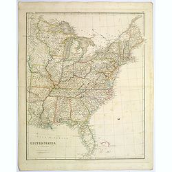
United States.
A lovely large map of the Untied States, as it was at the time of publication. Each state shown in a different outline color. Nothing is shown west of Louisiana, Arkansas...
Date: London, 1839

La parte orientale dell' antico.. messico con la Florida..
A splendid two-sheet map of Mexico, including California, Arizona, New Mexico, part of Texas, Baja California and Mexico (west part) and of the Southeast Part of the US, ...
Date: Rome, Calcography, 1797-before 1839