Recently Listed Listings
![[A Chinese vessel ] Naves Chinensibus usitatae velis arundineis & anchoris ligneis.](/uploads/cache/29498-250x250.jpg)
[A Chinese vessel ] Naves Chinensibus usitatae velis arundineis & anchoris ligneis.
Showing a Chinese vessel, print taken from Linschoten's famous voyages to the East of 1583-92, here published by De Bry the year after they first appeared as a separate b...
Date: Frankfurt, 1599
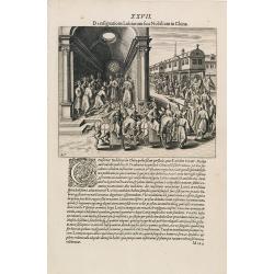
A Parade of Noblemen in China.
This famous and desirable scene from Linschoten's famous voyages to the East of 1583-92 is here published by De Bry the year after they first appeared as a separate book....
Date: Frankfurt, 1599
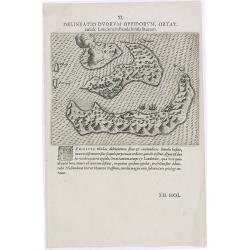
Delineatio Duorum Oppidorum, Ortat.
Early map of the Banda Islands.Theodore de Bry, a German engraver and book dealer, began a compilation of early voyages in 1590 and had published six parts at the time of...
Date: Frankfurt, 1609
Selling price: ????
Please login to see price!
Sold in 2025
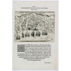
Delineatio Civitatis et Castelli Amboinae.
Early view of Ambon, with 6 Dutch vessels offshore.Theodore de Bry, a German engraver and book dealer, began a compilation of early voyages in 1590 and had published six ...
Date: Frankfurt, 1609
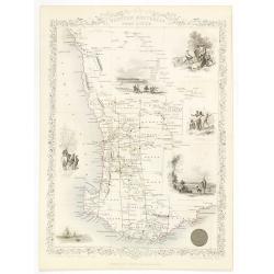
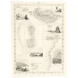
Western Australia. Swan River.
Decorative steel engraved map of part of Western Australia and Swan River, surrounded by illustrations of Perth, Aborigines and sheep shearing. With the seal of Western A...
Date: London, ca. 1851
Islands in the Atlantic.
Decorative steel engraved map of Islands showing the Azores, Madeira, Bermuda, the Canaries and the Cape Verdes. Interlocking border design. Taken from "The illustra...
Date: London, ca. 1851
Leaf on vellum from a manuscript Book of Hours.
RECTO: Panel border of acanthus leaves and flowers on a partly liquid gold and dark red ground, height 1-line initial in liquid gold on colored grounds and three line fil...
Date: France, ca. 1420-1480
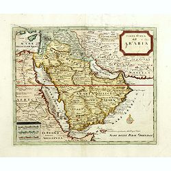
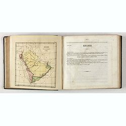
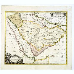
Carta nuova dell'Arabia.
Detailed map of Arabia and environs. Based on a map published by Isaak Tirion in Amsterdam, but here issued by Albrizzi with a modified title.More about Mapping of Arabia...
Date: Venice, 1740
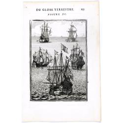
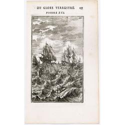
DU GLOBE TERRESTRE - Figure XC. 253
Finely engraved plate of various types of sailing ships.From the French text edition of Description d'Univers.. (5 volumes), 1683. By Allain Manneson Mallet (1630-1706), ...
Date: Paris, 1683
(Ships on full sea)
A fine engraving of different sailing vessels at full sea.From the French text edition of Description d'Univers.. (5 volumes), 1683. By Allain Manneson Mallet (1630-1706)...
Date: Paris, 1683

Nova Persiae Armeniae Natoliae et Arabiae.
This fine map shows the area East from Cyprus to Iran, including The Saudi Peninsula, Red Sea, Nile River, Cyprus, Asia Minor, the Gulf of Aden, the Indian Ocean, Armenia...
Date: Amsterdam, 1680
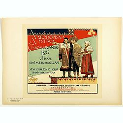
Rhodopsin Vistana Czechoslovakia 1895 . . .
Chromo lithographed poster of Les Maîtres de l'Affiche being plate n°56. The "Les Maîtres de l'Affiche" contained 256 small for lithographic prints of the be...
Date: Paris, Imprimerie Chaix, 1897
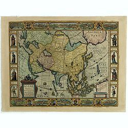
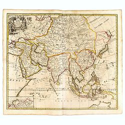
Asiae Nova Descriptio.
Final State of Pieter Van Den Keere's Rare Map of Asia--The first map of Asia to include decorative panels.The map has an interesting south positioning of the Caspian Sea...
Date: Amsterdam, 1636
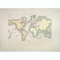
Planisfero (Tav III)
A large-format world map with a key to the steamship routes, telegraph lines and land routes in Europe. Finely engraved and beautifully colored and was prepared by Girola...
Date: Rome, 1858

Paskaerte Zynde t'Oosterdeel Van Oost Indien, met alle de Eylanden daer ontrendt geleegen van C. Comorin tota aen Iapan.
An eye-catching chart of Pieter Goos' sea chart of Australia, Southeast Asia, China, Japan, Korea and India. The chart shows the regions from Cape Comorin (Southern India...
Date: Amsterdam, 1669
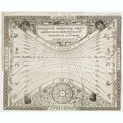
N°3. Horologium Horizontale Horas a meridie et media nocte Numeratas continens ad latitudinem XLIX GR XXIII Minut ec.
This beautiful engraving is a horological diagram with a 32-point wind rose at the bottom, signed underneath "M:Franciscus Ritter N fac A° 1640."It is remarkab...
Date: Nuremberg 1640
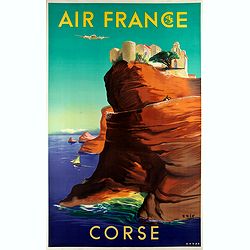
Air France - Corse.
Corsica poster for Air France, by Raoul Éric Castel (1915 - 1997) and published by Havas. Signed has work with Éric, he was born in Lyon and made many fine travel poste...
Date: Imprimerie Perceval Paris, ca. 1940-1950

Air France transporte tout partout.
Nice poster designed by Guy Georget, promoting the freight service of Air France.Guy Georget (1911-1992), was a French poster designer and illustrator. Georget's first co...
Date: Perceval, Paris, 1958

Géographie des Plantes Equinoxiales - Tableau physique des Andes et pays voisins. . .
Physical Portrait of the Andes and adjacent lands", organized around the Chimborazo and Cotopaxi volcanoes in Ecuador.With local vegetation is illustrated pictoriall...
Date: Paris, 1805
Manuscript leaf, on vellum from a book of hours.
The flesh side of the vellum has 4 large 1-line initial illuminated initials in blue and red with white heightening, on a very heavily burnished gold ground. 1 side illum...
Date: Paris, 1450
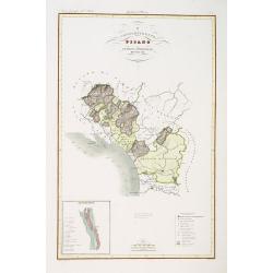
Governo di Venezia / Provincie di Padova e di Rovigo.
Very finely engraved and detailed map of the government of Venice. Lower left corner, two inset plans of Padova and Rovigo. Upper right corner, a key. Engraved by Vettori...
Date: Rome, 1860
![Quarta Etas Mndi. Carvilium / Aquileya. [Carovilli and Aquileia]](/uploads/cache/13525-250x250.jpg)
Quarta Etas Mndi. Carvilium / Aquileya. [Carovilli and Aquileia]
A lovely presentation of Carovilli, in the province of Cremona. Recto, a view of the town of Aquileya in Italy, centered on the castle and the high walls. Aquileia is an ...
Date: Nuremberg, 12 July 1493
![[Title page] Album delle principali vedute di Venezia disegnate da Marco Moro. . .](/uploads/cache/32269-250x250.jpg)
[Title page] Album delle principali vedute di Venezia disegnate da Marco Moro. . .
The title page has a virgin and the lion of Saint Mark sitting on an island with the background of the town of Venice. Learn more about map printing and views of Venice ...
Date: Venice, G. Brizeghel, ca 1860

Vorstellung der Evangelisch-Ostindischen Kirche Augsburger Protestanten.
It is a very decorative and rare print to commemorate the 200-year Confession of the Augsburg Protestant Confession. Engraved by J. Kleinschmidt after a design of E. Ridi...
Date: Augsburg, 1732

America settentrionale. . .
Rare map of North America drawn directly from the work of Nicholas De Fer and N. Sanson's famous map of 1650. The map is engraved by Antonius Donzel Gallus.With open Grea...
Date: Napels, 1766
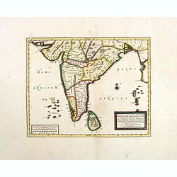
Carte du Golfe de Bengale, Mer de Indes, et Riviere du Gange, Avec les Pais et Iles d'alentour, Savoir les Cotes de Malabar, Cormandel, Ile de Ceylon, Les Maldives . . .
Detailed map of the Southern part of India with Ceylon. Good detail along the coasts of Malabar, Coromandel, the Maldives islands and the Kingdoms of Visipour, Golconda, ...
Date: Leiden, 1719
![Planisphere celeste Septentrional. . . [together with] Planisphere celeste meridional. . .](/uploads/cache/35291-250x250.jpg)
Planisphere celeste Septentrional. . . [together with] Planisphere celeste meridional. . .
Beautiful set of celestial charts of the northern and southern skies by the well-known French astronomer, Philippe de La Hire. Surrounded by panels of astronomical notes ...
Date: Paris, ca.1775
Bibliomappe. Chronologie Historique et Géographique par MM. Année et Vivien bound with : Bibliomappe, ou Livre-Cartes: Leçons Méthodiques de Chronologie et de Géographie, . . .
With 67 maps (1 folding) by A.M. Perrot. Published in Paris. Most maps have original color. The atlas is complete very rare, as it was issued in 15 separate installments ...
Date: Paris, Renard, 1827 / 1824-1826
A New Map of Asia from the latest Observations Most Humbly Inscrib'd to the Right Honbl. George Earl of Warrington &c.
Fine map of Asia, with decorative title cartouche flanked by two figures in Asian dress, along with flora and fauna of the continent., based on the work of Guillaume De L...
Date: London, 1721
Plan de la ville de Louvo . . .
Early plan of Louvo city. Across the top is an extensive list of 22 important sites and locations keyed to the plan with tiny letters and numbers.Jacques Nicolas Bellin (...
Date: Paris, 1750

L'Inde de la le Gange, suivant les nouvelles observations...
Uncommon edition of this map of Malaysia, Thailand, Indo China and the Northern parts of the islands of Sumatra and Borneo. Singapore marked as Sincapour. With decorative...
Date: Amsterdam, 1728

Carte de L'Isle de Sumatra Dressee sur les Journaux des Navigateurs . . .
Detailed map of Sumatra and Malacca, centered on Singapore and including the southern portion of the Malaysian peninsula. With "Detroit de Sincapour" and severa...
Date: Paris, ca. 1750
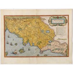
Thusciae Descriptio Auctore Hieronimo Bellarmato.
Decorative and detailed map of Tuscany, from the 1574 or 1575 Latin text edition of Ortelius' Theatrum Orbis Terrarum, the first modern atlas of the world. The map is bas...
Date: Antwerp, 1574-1575
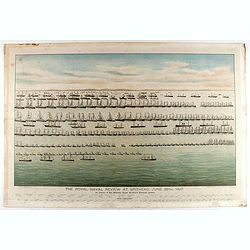
The Royal Naval review at Spithead, June 26th, 1897. In Honour of Her Majesty Queen Victoria's Diamond Jubilee.
A very decorative and large chromolithographed plate showing a line up of international vessels at Spithead, June 26th, 1897 In Honour of her Majesty Queen Victoria'a Dia...
Date: Portsea, ca. 1897
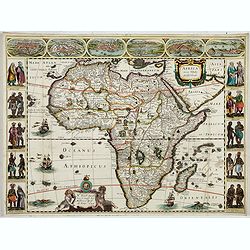
Africa nova Tabula.
Very rare map of Africa separately published. This derivative map by Nicolas Picart is based upon the second state of Janssonius' map of 1623, after the lower border had ...
Date: Paris, 1644
Selling price: ????
Please login to see price!
Sold in 2023
![Recueil de costumes. Imagini degl'abiti con cui Va uestita la Nobiltà della Serenis.ma Republica di Venezia. Suivi de: [Augsburger Kleidertrachten].](/uploads/cache/48425-250x250.jpg)
Recueil de costumes. Imagini degl'abiti con cui Va uestita la Nobiltà della Serenis.ma Republica di Venezia. Suivi de: [Augsburger Kleidertrachten].
Imagini degl'abiti con cui Va uestita la Nobiltà della Serenis.ma Republica di Venezia. Dedicate all'Illmo et Ecc.mo Sig.r Andrea da Leze Degnis.mo Proc.tor di S: Marco....
Date: Venezia, Ragheno, 1702 / Augsbourg, J. Wolff, ca. 1715
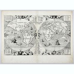
Benedict. Arias Montanus Sacrae Geographiae Tabulam Ex Antiq
THE EXTREMELY RARE FIRST STATE landmark world map, famed for its depiction of the Australian landmass.One of the earliest printed maps to depict the “terra incognita�...
Date: Anvers 1571 /1572
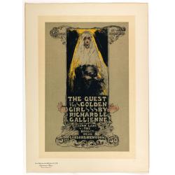
The quest of the golden girl . . .
Chromo lithographed poster, " The quest of the golden girl . . .", after Miss Ethel Reed (American, 1876–d. ca. 1925). Plate 128, published in Maître 32, on ...
Date: Paris, Imprimerie Chaix, April 1898

L'Amerique Septentrionale.
Very rare map, from "Metaphaste Barbao, Descriptio Indiae Occidentalis et America Nova" published by Henrico Verdussen.The map is a copy of Guillaume de L'Isle'...
Date: Antwerp, 1702

P.les de Virginie.
Attractive copper engraving, depicting a couple of native people of Florida.From the French text edition of Description d'Univers, 1683. by Allain Manneson Mallet (1630-1...
Date: Paris, 1683
Carte de l'Empire de Perse. . .
Map of the Persian empire by the Venetian cartographer and publisher François (Père) Santini and first published in Santini's 'Atlas Universel dressée sur les meuilleu...
Date: Venice, 1784
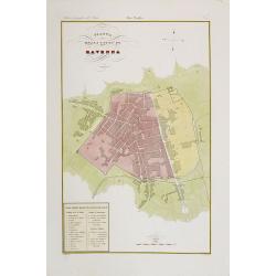
Pianta della citta di Ravenna.
Very finely engraved and detailed plan of Ravenna. Engraved by V.Angeli and included in: Atlante Geografico dell Italia. To the lower left a key to the principal building...
Date: Rome, 1860
IV Compartimento Aretoni. . .
Very finely engraved and detailed map centered on Arezzo and Lago Trasimeno. Lower part three inset plans of Cortona, Arezzo and Chiusi. In upper corners plans of Montepu...
Date: Rome, 1860
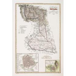
Divisione militaire di Novara. Provincie di Valsesia e di Vercelli.
Very finely engraved and detailed map centered on Vercelli and Varalio. Lower part two inset plans of Vercelli and Varallo and sacro Monte. Engraved by Pietro Manzoni and...
Date: Rome, 1860
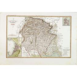
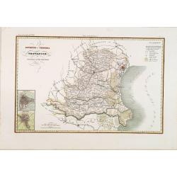
Governo di Venezia / Provincia di Udine.
Very finely engraved and detailed map of the area of Udine, with Trieste in lower right corner. Lower left corner an inset plan of Trieste : upper right corner, an inset ...
Date: Rome, 1860
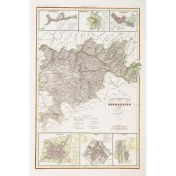
Compartimento Fiorentino. (Florence)
Very finely engraved and detailed map of the province of Firenze (Florence) Upper and lower part of the map, three inset plans of Namminiato, Modigliani and Volterra, Pis...
Date: Rome, 1860
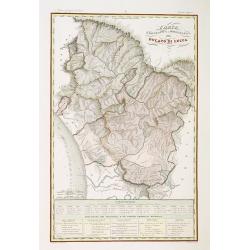
Ducato di Lucca.
Very finely engraved and detailed map of the region around Lucca. Lower part of the map, two inset lists of the mountains height and the local minerals. Engraved by Vetto...
Date: Rome, 1860
Compartimento Pisano.
Very finely engraved and detailed map of the territory of Pisa, including the region of Lucca and Estense. Lower left corner, an inset plan of Pontremoli. In the lower ri...
Date: Rome, 1860
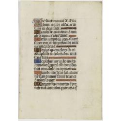
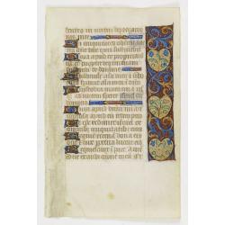
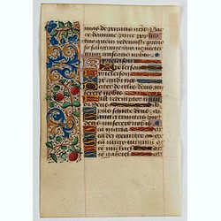
Leaf on vellum from a manuscript Book of Hours.
RECTO: One 2-lines initial decorated with flower in liquid gold on colored grounds and six 1-line initials in liquid gold on colored grounds and five line-fillers in same...
Date: France, c. 1520

Nova Virginia Tabula.
A beautifully engraved map, derived from the highly influential map by Captain John Smith in 1612, showing Chesapeake Bay and the surrounding area. The decoration of this...
Date: Amsterdam, J.Meurs, 1671

Le Chantier d'Amsterdam.
Decorative lithography representing the head quarters of the V.O.C. and shipyard in Amsterdam. The building serves nowadays as the Maritime Museum. After a painting by A....
Date: Brussels, J. B. A. Jobard, 1825
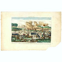
Bataille de la Moskwa Remportée par l'Armée Française le 7 Septembre 1812...
Uncommon print showing the siege of Moscow on September 7, 1812 by Napoleon Bonaparte.Jean was a well-known publisher of optical prints and other popular prints, establis...
Date: Paris, ca. 1815

Missions et Résidences dans la Partie Septentrionale de l'Amérique Contenant 50 Jésuites.
Very rare missionary map of North America from "Atlas Universel indiquant les établissemens des Jésuites: avec la manière dont ils divisent la terre, suivi desév...
Date: Paris, Ambroise Dupont , 1826

Nieuwe kaart van Kanada . . .
Nice map of the Bay of Hudson, In Labrador, a small inset of Nova Scotia. The map is dated 1769. All text is in Dutch. The map shows the region shortly after the conclusi...
Date: Amsterdam, 1769

Mapa Polski i Krajów Osciennych - Wydanie trzecie. Opracowal Stanislaw Max. Wydani M. Arcta.
‘The Birth of Modern Poland on a map’ - an excellent wall map of Poland and surrounding regions, published in Warsaw near the end of World War I, when Poland’s fate...
Date: Warsaw, [H. Sklodowski], 1918
Arabiae Felicis, petrae et desertae.
A very striking map with a finely decorated title cartouche, published by Valk & Schenk, utilizing Jansson's original plate. Interestingly, this map uses the names th...
Date: Amsterdam, 1720
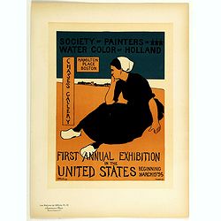
First annual exhibition in the United States . . .
Chromo lithographed poster of Les Maîtres de l'Affiche being plate n°112. The "Les Maîtres de l'Affiche" contained 256 small for lithographic prints of the b...
Date: Paris, Imprimerie Chaix, 1898
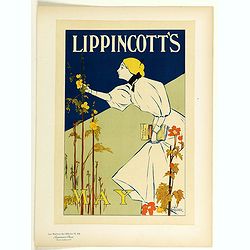
Lippincott's, May.
Chromo lithographed poster of Les Maîtres de l'Affiche being plate n°44. The "Les Maîtres de l'Affiche" contained 256 small for lithographic prints of the be...
Date: Paris, Imprimerie Chaix, 1896
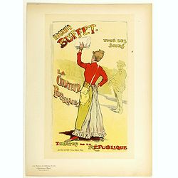
Eugenie Buffet ... La chanteuse populaire.
Chromo lithographed poster of Les Maîtres de l'Affiche being plate n°151. The "Les Maîtres de l'Affiche" contained 256 small for lithographic prints of the b...
Date: Paris, Imprimerie Chaix, 1899
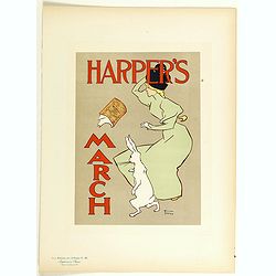
Harper's, March.
Chromo lithographed poster of Les Maîtres de l'Affiche being plate n°20. The "Les Maîtres de l'Affiche" contained 256 small for lithographic prints of the be...
Date: Paris, Imprimerie Chaix, 1896
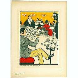
Recklame Plankater . . .
Chromo lithographed poster of Les Maîtres de l'Affiche being plate n°84. The "Les Maîtres de l'Affiche" contained 256 small for lithographic prints of the be...
Date: Paris, Imprimerie Chaix, 1897
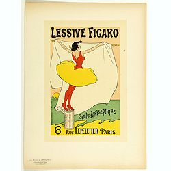
Lessive Figaro.
Chromo lithographed poster of Les Maîtres de l'Affiche being plate n°71. The "Les Maîtres de l'Affiche" contained 256 small for lithographic prints of the be...
Date: Paris, Imprimerie Chaix, 1896
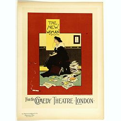
The new woman . . .
Chromo lithographed poster of Les Maitres de l'Affiche n°79. The "Les Maitres de l'Affiche" contained 256 small for lithographic prints of the best posters of ...
Date: Paris, Imprimerie Chaix, 1896
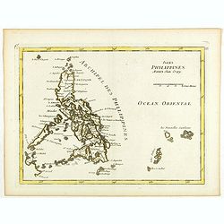
Isles Philippines.
Fine map of the Philippines. George Louis Le Rouge was active from 1740- till 1780 as a publisher, and was appointed engineer for the King of France. From his Atlas Nouve...
Date: Paris, 1756
![Les Isles Philippines [on sheet with] Islas de los Ladrones ou Isle des Larrons.](/uploads/cache/42023-250x250.jpg)
Les Isles Philippines [on sheet with] Islas de los Ladrones ou Isle des Larrons.
Sanson's important mid-seventeenth-century map of the Philippines and tha Ladrones.It was first engraved by J. Somer for the elder Nicolas Sanson with a privilege for twe...
Date: Amsterdam/Utrecht, 1654
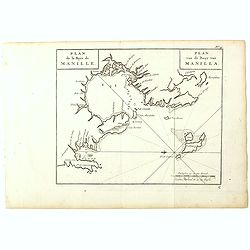
Plan de la Baye de Manille. / Plan van de Baay van Manilla.
Detailed plan of Manila Bay after George Anson's key plan of the Bay of Manila. With a compass rose and soundings in the Bay. East to the top.This is the rare Dutch editi...
Date: Amsterdam, Arkstee and Merkus, 1751
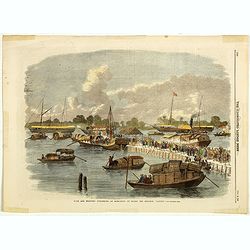
Sick and wounded embarking at Hong-Kong on Board the Steamer.
Large view of the harbour with numerous ships and people. From the Illustrated London News, October 23, 1858.
Date: London, October 1858
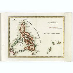
Isles Philippines.
Fine map of the Philippines. George Louis Le Rouge was active from 1740- till 1780 as a publisher, and was appointed engineer for the King of France. From his Atlas Nouve...
Date: Paris, 1756
![Terre de Diemen. Grou-Agara. [plate X]](/uploads/cache/46273-250x250.jpg)
Terre de Diemen. Grou-Agara. [plate X]
A portrait of the Tasmanian Aboriginal Grou-Agara, after the original sketches by Lesueur, from Voyage de découvertes aux terres Australes by François Péron, 1824.The ...
Date: Paris, 1824
Selling price: ????
Please login to see price!
Sold in 2024
![Terre de Diemen. Arra-Maida. [plate XII]](/uploads/cache/46275-250x250.jpg)
Terre de Diemen. Arra-Maida. [plate XII]
A portrait of a female Tasmanian Aboriginal Arra-Maida, after the original sketches by Lesueur, from Voyage de découvertes aux terres Australes by François Péron, 1824...
Date: Paris, 1824
Selling price: ????
Please login to see price!
Sold in 2024
![Terre de Diemen. Tombeaux des naturels. [plate XVI]](/uploads/cache/46279-250x250.jpg)
Terre de Diemen. Tombeaux des naturels. [plate XVI]
An aboriginal campfire, near the ruins of an old wooden fence, and a dead tree, after the original sketches by Lesueur, from Voyage de découvertes aux terres Australes b...
Date: Paris, 1824
![Nouvelle-Hollande. Gnoung-A-Gnougn-A, Mour-Re-Mour-Ga ( Dit Collins). [plate XVII]](/uploads/cache/46280-250x250.jpg)
Nouvelle-Hollande. Gnoung-A-Gnougn-A, Mour-Re-Mour-Ga ( Dit Collins). [plate XVII]
A portrait of a male Tasmanian Aboriginal Gnoung-A-Gnougn-A, Mour-Re-Mour-Ga ( Dit Collins) by Lesueur, from Voyage de découvertes aux terres Australes by François Pér...
Date: Paris, 1824
![Terre de Diemen. Ourlaga. [plate IX]](/uploads/cache/46272-250x250.jpg)
Terre de Diemen. Ourlaga. [plate IX]
A portrait of the female Tasmanian Aboriginal Ourlaga, after the original sketches by Lesueur, from Voyage de découvertes aux terres Australes by François Péron, 1824....
Date: Paris, 1824
Selling price: ????
Please login to see price!
Sold in 2024

Carte de la Nouvelle France, ou se voit le cours des Grandes Rivieres de S. Laurens & de Mississipi..
Derived from de Fer's 1718 map, from west of the Mississippi it contains a mass of inland detail with notes and vignettes of the indigenous peoples and fauna of North Ame...
Date: Amsterdam, 1720
![Nouvelle-Hollande: Nelle. Galles du sud - Navigation. [plate XXIII]](/uploads/cache/46345-250x250.jpg)
Nouvelle-Hollande: Nelle. Galles du sud - Navigation. [plate XXIII]
An aboriginal camp fire, with a pirogue and two men navigating , after the original sketches by Lesueur, from Voyage de découvertes aux terres Australes by François Pé...
Date: Paris, 1824
![Nouvelle-Hollande: Terre dEndracht - Cabane des naturels de la Presqu'Ile de Péron. [plate XXIV]](/uploads/cache/46346-250x250.jpg)
Nouvelle-Hollande: Terre dEndracht - Cabane des naturels de la Presqu'Ile de Péron. [plate XXIV]
An aboriginal camp fire, after the original sketches by Lesueur, from Voyage de découvertes aux terres Australes by François Péron, 1824.The French expedition under Ni...
Date: Paris, 1824
![Timor. Naba-Leba Roi de L'Ile Solor. [plate XXV]](/uploads/cache/46347-250x250.jpg)
Timor. Naba-Leba Roi de L'Ile Solor. [plate XXV]
A portrait of a male Naba-Leba by Lesueur, from Voyage de découvertes aux terres Australes by François Péron, 1824.The French expedition under Nicolas Baudin, was comm...
Date: Paris, 1824
![Timor. Canda Jeune fille Malaise. [plate XXVI]](/uploads/cache/46348-250x250.jpg)
Timor. Canda Jeune fille Malaise. [plate XXVI]
A portrait of a female Canda by Lesueur, from Voyage de découvertes aux terres Australes by François Péron, 1824.The French expedition under Nicolas Baudin, was commis...
Date: Paris, 1824
![Nouvelle-Hollande: Ile King. - L'Eléphant -marin ou Phoque à trompe. [plate XXXII]](/uploads/cache/46354-250x250.jpg)
Nouvelle-Hollande: Ile King. - L'Eléphant -marin ou Phoque à trompe. [plate XXXII]
Plate illustrating seals by Lesueur, from Voyage de découvertes aux terres Australes by François Péron, 1824.The French expedition under Nicolas Baudin, was commission...
Date: Paris, 1824
![Timor. Rhinolophe Cruménifére. [plate XXXV]](/uploads/cache/46357-250x250.jpg)
Timor. Rhinolophe Cruménifére. [plate XXXV]
Plate illustrating Horseshoe bats from Timor Island, by Lesueur, from Voyage de découvertes aux terres Australes by François Péron, 1824.The French expedition under Ni...
Date: Paris, 1824