Recently Listed Listings in America

Carte Geographique, Statistique et Historique de l'Amerique Meridionale.
A nice detailed map of South America from Buchon's Atlas Gégraphique Statistique, historique et chronologique des deux Ameriques et des isles adjacentes traduit de l'atl...
Date: Paris, 1825

Carte Geographique, Statistique et Historique du Perou.
A nice detailed map of Peru from Buchon's Atlas Gégraphique Statistique, historique et chronologique des deux Ameriques et des isles adjacentes traduit de l'atlas exécu...
Date: Paris, 1825

Carte Geographique, Statistique et Historique de Buenos-Ayres.
A nice detailed map of what is today northern Argentina (Rep. of Buenos Ayres or the United Provinces of South America) from Buchon's Atlas Gégraphique Statistique, hist...
Date: Paris, 1825
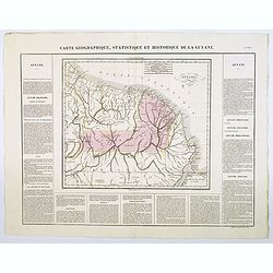
Carte Geographique, Statistique et Historique de la Guyane.
A nice detailed map of Guyana from Buchon's Atlas Gégraphique Statistique, historique et chronologique des deux Ameriques et des isles adjacentes traduit de l'atlas exé...
Date: Paris, 1825
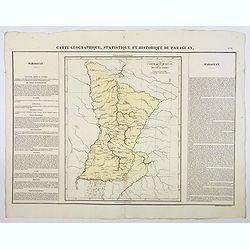
Carte Geographique, Statistique et Historique du Paraguay.
A nice detailed map of Paraguay from Buchon's Atlas Gégraphique Statistique, historique et chronologique des deux Ameriques et des isles adjacentes traduit de l'atlas ex...
Date: Paris, 1825
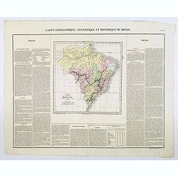
Carte Geographique, Statistique et Historique du Bresil.
A nice detailed map of Brazil from Buchon's Atlas Gégraphique Statistique, historique et chronologique des deux Ameriques et des isles adjacentes traduit de l'atlas exé...
Date: Paris, 1825

Cunard to Canada.
Poster by Charles Eddowes Turner for Cunard lines. The poster shows The NEW SYLVANIA, one of the four new 22,000 - ton Cunarders which are the largest ever built for serv...
Date: England, ca. 1930

A Map of the British Empire in AMERICA with the French, Spanish and Hollandish Settlements Adjacent Thereto. by Henry Popple. / Nouvelle Carte Particuliere de L'Amerique . . .
The four sheet Dutch edition of Popple's monumental map of North America, in mint condition. Encompassing the West Indies, Florida, Louisiana, Texas and Central America.T...
Date: Amsterdam, ca. 1737

Coast to Coast.
A game board that features a map of the U.S. with a built-in spinner. Players travel a circular track around the map visiting landmarks as they go. A fun way to learn geo...
Date: New York, ca. 1950

San Diego Bay. (Chart 5107)
Nautical chart of San Diego Bay of 1945. Printed in black, yellow and purple the "Seaward limit defensive sea area". The water area within the indicated limits ...
Date: Washington, 1945

Nader prolongatie van het Octroy voor de Westindische Compagnie voor den tyd van nog dertig jaaren. . .
A proclamation by the Dutch States General, dated 1761, extending the charter of the Dutch West India Company for another thirty years. Like the 1730 proclamation, it has...
Date: Amsterdam, 1761
![ISLA DE CUBA [with 2 maps] Plano Pintoresco De La Habana con los numeros de las casas B. May y Ca. 1853. (with) Inset map Puerto y Cereanias De La Habana. (with) 14 views of Havana & prominent buildings.](/uploads/cache/36720-250x250.jpg)
ISLA DE CUBA [with 2 maps] Plano Pintoresco De La Habana con los numeros de las casas B. May y Ca. 1853. (with) Inset map Puerto y Cereanias De La Habana. (with) 14 views of Havana & prominent buildings.
Lithographic town-plan surrounded with views of the city of Havana including the "Fuente De La India En El Paseo De Isabel 2a." and "Vista Gral De La Haban...
Date: Havana, 1853

Nuevo plano de la ciudad de Buenos Aires y parte del partido de avellaneda . . .
A rare detailed city plan of Buenos Aires prepared in 1912 by Ernesto Escalante. The plan depicts the city from the Partido de Avellaneda and the Villa Riachuelo to the R...
Date: Buenos Aires, 1912
![Hanc Tabulam continens Laetam Pharnambuci.. . [Brazil].](/uploads/cache/16521-250x250.jpg)
Hanc Tabulam continens Laetam Pharnambuci.. . [Brazil].
An extremely rare and decorative map of coast-line of Pernambuco. With one inset: In the upper left corner a map of Brazil, with title in five lines Dutch and five lines ...
Date: Amsterdam, 1630

A new map of the English Empire in America. . .
This fine English map of eastern North America including Canada engraved by John Harris and first published by Robert Morden. John Senex acquired and made minor alteratio...
Date: London, 1720

Entrée des forêts de la rivière Sedger. . .
Exquisite contemporary colored lithograph of Sedger's river in the Chili, with as seen by Dumont D'Urville's, with Indians. Drawn by Louis Le Breton, lithographed by Bich...
Date: Paris, 1846

Rivage du port Saint-Nicolas.
Exquisite contemporary colored lithograph of Port Saint-Nicolmas Bay in most southern part of South America, with Dumont D'Urville's officers making landfall. Drawn by E....
Date: Paris, 1846

Occidentalis Americae partis.
The most beautifully engraved early map of the Caribbean, including Florida and the Southeast. The map includes representations of Columbus' ships and various notes regar...
Date: Frankfurt, 1594

Nieuwe Wassende Graadige Pas-kaart van de Kust van Guinea en Brasilia.
Rare two-sheet sea chart of the coasts of Brazil, West Africa and South Africa, published by Johannes Van Keulen (the younger), circa 1720.The chart shows the western coa...
Date: Amsterdam, 1751

Americae Sive Novi Orbis, Nova Descriptio.
This is the second copperplate of Ortelius' map showing the western hemisphere, showing the prominent bulge in the South American coastline. An important map because of i...
Date: Antwerp, 1579
![The Coast of New Found Land From Salmon Cove to Cape Bonavista. . . [together with] The Coast of New Found Land from Cape-Raze to Cape St-Francis.](/uploads/cache/40658-250x250.jpg)
The Coast of New Found Land From Salmon Cove to Cape Bonavista. . . [together with] The Coast of New Found Land from Cape-Raze to Cape St-Francis.
Two charts showing the coast of New Found Land from Salmon Cove to Cape Bonavista and from Cape-Raze to Cape St-Francis. With inset chart of Trinity HarborGrierson publis...
Date: Dublin, 1767

Nova Virginiae Tabula.
A fine example of Blaeu's map of Virginia and the Chesapeake region is based on the first state of Smith's map, 1612, and is slightly larger and more expertly engraved.Th...
Date: Amsterdam, 1640

(Totius Americae nova et exacta tabula ex) optimis tum geographorum tum aliorum scriptis collecta et ad hodiernam regnorum principatuum et maiorum partium distinctionem accomodata.
Eastern part of a two-sheet map of America, with attribution to Willem Blaeu. According to Philip Burden, the map was derived from Cornelius Danckert's 1647 map of the sa...
Date: Rome, 1679
![[Incas lay siege to Cusco.]](/uploads/cache/40353-250x250.jpg)
[Incas lay siege to Cusco.]
Atahualpa’s brother, Manco, organized a long and bloody siege to reoccupy the Inca capital, which eventually spread to open rebellion throughout the land. Pizarro, who ...
Date: Frankfurt, M.Merian, 1633
Selling price: ????
Please login to see price!
Sold in 2025
![[The Dutch covalesce on the Isle Santa Clara.]](/uploads/cache/40359-250x250.jpg)
[The Dutch covalesce on the Isle Santa Clara.]
Fanciful map of the Island of Santa Clara (Isla Do Francez), as seen by the Dutch in 1599, during the exploration of Olivier de Noort, published by Theodore de Bry, one y...
Date: Frankfurt, M.Merian, 1633
![[Soil map] Virginia-Maryland-West Virginia, Leesburg sheet.](/uploads/cache/23257-250x250.jpg)
[Soil map] Virginia-Maryland-West Virginia, Leesburg sheet.
Early color lithographed soil map by Julius Bien & Co. in New York for Department of Agriculture. Legends at side give detail on soil type, etc. They also include int...
Date: New York, 1903

A-Na-Cam-E-Gish-Ca. A Chippeway Chief.
Half-length portrait of Anacamegishca, bare-chested, wearing a blanket and a peace medal. A-Na-Cam-E-Gish-Ca (1785-1862) - was a Chippewa (Ojibwe) Native American chief. ...
Date: Philadelphia, 1837

Ca-Ta-He-Cas-Sa-Black Hoof. Principal Chief of the Shawanoes.
Half-length portrait of Catahecassa wearing a dark colored jacked, grey vest, white shirt, and grey head scarf. A wonderful hand colored lithograph of Ca-Ta-He-Cas-Sa-Bl...
Date: Philadelphia, 1837

Major Ridge. A Cherokee Chief.
Head and shoulders portrait of Major Ridge,(1771-1839) wearing a blue jacket, gold or yellow vest, white shirt, and black cravat. A Cherokee Chief, who as a Cherokee lead...
Date: Philadelphia, 1837

Carte du Canada ou de la Nouvelle France.
A later edition of Guillaume De l'Isle's map. It still includes the fictitious discoveries of Baron de Lahoutan: the legendary River Longue etc. The northwest corner of H...
Date: Amsterdam, 1730

Guyana, Surinam, Amapa.
Very rare Ottoman printed map of Guyana, Suriname and Amapa. With Trinidad, an inset map of the mouth of the Rivers Essequibo, Courantyne, Suriname with Paramaribo.From C...
Date: Uskudar (Istanbul), 1803
Selling price: ????
Please login to see price!
Sold in 2024

Carte des Iles Hawaii.
A lovely small map of the complete chain of Pacific islands known today as the Hawaiian islands, from Dumont d'Urville's atlas "Voyage pittoresque autour du Monde.&q...
Date: Paris, 1834

Americae Pars Magis Cognita. Chorographia nobilis & opulentae Peruanae Provinciae, atque Brasiliae, . . . MDXCII
First state. Although a map of South America it does include much of what is now the southern United States. There are two elaborate, strap-work cartouches with the one a...
Date: Frankfurt, 1592

Plan of Yonkers Town of Yonkers Westchester Co. N.Y. . . .
Fine lithographed map of Yonkers, New York. The map provides the names of specific homeowners, as well as information about the occupations and physical locations of the ...
Date: New York, 1867

Plan of the Borough of New Rochelle, Westchester Co. N.Y.
Fine lithographed map of the plan of the Borough of New Rochelle. The map provides the names of specific homeowners, as well as information about the occupations and phys...
Date: New York, 1867

Plan of the Beekmanton Tarryntown and Ivring. Westchester Co. N.Y.
Fine lithographed map of the plan of the Beekmantown, Tarrytown, and Irving, New York. The map provides the names of specific homeowners, as well as information about the...
Date: New York, 1867

New Jersey entworfen von D.F. Sotzmann. Hamburg bey Carl Ernst Bohn 1796 . . . NO.VIII
Extremely rare map of New Hampshire prepared by Daniel Friedrich Sotzmann for Christopher Ebeling's "Erdbeschreibung von Amerika", a project ended after only te...
Date: Hamburg, Carl Ernst Bohn, 1797

New Yok entworfen von D.F. Sotzmann. Hamburg bey Carl Ernst Bohn 1799 . . . NO.VII
An extremely rare map of New York prepared by Daniel Friedrich Sotzmann for Christopher Ebeling's "Erdbeschreibung von Amerika", a project ended after only ten ...
Date: Hamburg, Carl Ernst Bohn, 1799

Rhode Island entworfen von D.F. Sotzmann. Hamburg bey Carl Ernst Bohn 1798 . . . NO.V
Extremely rare map of Rhode Island prepared by Daniel Friedrich Sotzmann for Christopher Ebeling's "Erdbeschreibung von Amerika", a project ended after only ten...
Date: Hamburg, Carl Ernst Bohn, 1797

Americae Nova Descriptio.
Final state. According to Philip Burden, "this scarce map is America's first single-sheet map with decorative borders." A re-issue of the 1614 plate by Pieter v...
Date: Amsterdam, 1652

A plan of the City and Environs of Philadelphia. . .
The Lotter edition of Scull & Heap's seminal Philadelphia map, which map was first issued in 1752.Holmes' grid plan for the city is shown, situated between the rivers...
Date: Augsburg, 1777

North and South America At-A-Glance.
A clever device for demonstrating the statistics of each country, the Area, Population, Population per Sq. Mile, Highest Elevation, Principal River, Currency, Capital, Fo...
Date: New York & London: International At-A-Glance Chart Co. 1931

United States At-A-Glance.
A clever device for demonstrating the statistics of each state, the Area, Population, Highest Elevation, Principal River, Capital, railroad Mileage, Date Entered Union, P...
Date: New York / London: International At-A-Glance Chart Co. 1931

Mar del Zur, Hispanis Mare Pacificum.
Janssonius' fine chart of the Pacific including the west coast of America with California shown as an island, Japan and a small Australian coastline. This is the earliest...
Date: Amsterdam, 1650

20 small lithographed views of Washington DC and Georgetown.
20 small lithographed town-views of Washington DC and Georgetown, cut out from a larger sheet. Showing the East Front of the Capitol, Treasury, Smithsonian Institute, Pre...
Date: Casimir Bohn, Washington, D.C.: 1849

Kiepert's Physikalische Wandkarten. VI. Nord-America.
Large folding school wall map of North and Central America printed in chromo-lithography. Published by Dieter Reimer and printed by Leopold Kraatz in Berlin. Three inset...
Date: Berlin, Dieter Reimer, 1864

Il Cuscho citta principale della provincia del Peru.
A very desirable and scarce item of this decorative and early bird's-eye town-plan of the Inca city of Cuzco. Several figures shown inside the city walls and on the hills...
Date: Lyons, 1564

Novissima et Accuratissima Totius Americae Descriptio.
Second state of Visscher's map of the Americas, this decorative map greatly influenced the cartography of the Americas both geographically and artistically.Although it di...
Date: Amsterdam, 1677

Poli Arctici, et circumiacentium terrarum descriptio novissima. . .
A re-issue of the Hondius' plate. A particularly decorative map of the North Pole with Iceland. Several Dutch names in Labrador. The toponymy in Canada reflects the conti...
Date: Amsterdam, 1660

Manuscript plan of Havana harbour.
Manuscript chart with good nautical detail and soundings of Havana harbour.
Date: Spain c.1820

New York Ferry Boat. (Bac à vapeur de New York).
A very decorative print showing the New York Ferry Boat "Fulton," published by Currier & Ives. The Ferry boat "Fulton" sails to the right. A singl...
Date: New York, ca. 1875

Nieuwe gemeten kaart van de colonie de Berbice : met der zelver plantagien en de namen der bezitters in het ligt gebragt door Reiner & Iosua Ottens kaartverkopers te Amsterdam 1740.
Rare separately published map of the colony of Berbice in present-day Guyana showing the Berbice River Valley and the plantations along the river. North on map of the col...
Date: Amsterdam, 1740

Carte Réduite De La Partie Septentrionale De L'' Isle De Terre Neuve..
A well engraved and highly detailed chart, corrected to 1767. Elaborate hand-colored cartouche, rhumb lines.Shows northern part of Newfoundland and southern coast of Labr...
Date: Paris, 1767

La Florida/ Peruviae Auriferae regionis Typus/ Guastecan.
The Chaves map of Florida is a prime example of an explorer's map since it records the recent discoveries of Cabeza de Vaca, De Soto, and Moscoso. The map revealed little...
Date: Antwerp, 1592

Ilse Paese de' Selvaggi.. Lago Superiore. (Florida and the Bahamas)
Antonio Zatta published an Italian version of the John Mitchell map in twelve sheet. This sheet depicts Lake Superior in the Bellin version, as it appeared on the Mitchel...
Date: Venice, 1778

Carte des côtes du Golfe du Mexique compris entre la pointe sud de la presqu'Ile de la Floride et la pointe nord de la presqu'Ile d'Yucatan:...
Detailed and important early chart of the Gulf Coast and Florida and dated 1800. First French edition of "the first printed [map] to show and name Galveston Bay&qu...
Date: Paris, 1800/1803
![[Canadian Indian traditional garments ].](/uploads/cache/27544-250x250.jpg)
[Canadian Indian traditional garments ].
Aquatint depicting Canadian Indian traditional garments engraved by Gallina. Plate N°32.From Giulio Ferrario's work Le Costume Ancien et Moderne ou Histoire du gouvernem...
Date: Milan, 1827
![[Canadian Indians ].](/uploads/cache/27546-250x250.jpg)
[Canadian Indians ].
Aquatint depicting a group of Canadian Indians engraved by Gallina. Plate N° 33 n°1.From Giulio Ferrario's work Le Costume Ancien et Moderne ou Histoire du gouvernement...
Date: Milan, 1827
![[View of the Potomac River from Mount Vernon ].](/uploads/cache/27550-250x250.jpg)
[View of the Potomac River from Mount Vernon ].
Aquatint depicting a view of the Potomac River from Mount Vernon engraved by Fumagalli. Plate N°46.From Giulio Ferrario's work Le Costume Ancien et Moderne ou Histoire d...
Date: Milan, 1827
![[Florida Indian cooking ].](/uploads/cache/27561-250x250.jpg)
[Florida Indian cooking ].
Aquatint depicting Florida Indian cooking engraved by Fumagalli. Plate N°54.From Giulio Ferrario's work Le Costume Ancien et Moderne ou Histoire du gouvernement, de la m...
Date: Milan, 1827
![[Slave labor on an indigo plantation ].](/uploads/cache/27564-250x250.jpg)
[Slave labor on an indigo plantation ].
Aquatint depicting slave labor on an indigo plantation engraved by Fumagalli. Plate N°51.From Giulio Ferrario's work Le Costume Ancien et Moderne ou Histoire du gouverne...
Date: Milan, 1827
![[Slave labor on a Tobacco plantation ].](/uploads/cache/27565-250x250.jpg)
[Slave labor on a Tobacco plantation ].
Aquatint depicting slave labor on an tobacco plantation engraved by Biasioli. Plate N°50.From Giulio Ferrario's work Le Costume Ancien et Moderne ou Histoire du gouverne...
Date: Milan, 1827
![[ Indian accessories ].](/uploads/cache/27566-250x250.jpg)
[ Indian accessories ].
Aquatint depicting Indian accessories engraved by Gallina. Plate N°49.From Giulio Ferrario's work Le Costume Ancien et Moderne ou Histoire du gouvernement, de la milice,...
Date: Milan, 1827
![[ Chief Regolo ].](/uploads/cache/27567-250x250.jpg)
[ Chief Regolo ].
Aquatint depicts Chief Regolo (also called Cacique) accompanied by his women, who are engraved by Gallina. Plate N°57.Cacique from the taíno word for the pre-Columbian ...
Date: Milan, 1827
![[ Chief Regolo ].](/uploads/cache/27568-250x250.jpg)
[ Chief Regolo ].
Aquatint depicting chief warriors engraved by G. G. Plate N°58.Cacique from the taíno word for the pre-Columbian tribal chiefs or leaders of the Taino tribes in the Bah...
Date: Milan, 1827
![[ Cofre de Perote ].](/uploads/cache/27569-250x250.jpg)
[ Cofre de Perote ].
Aquatint depicting the Cofre de Perote engraved by Fumagalli. Plate N°59.Cofre de Perote, mean something like 'Mountain of the Lord of Four Places'. This extinct volcano...
Date: Milan, 1827
![[ Regla columnar basalt quarry ].](/uploads/cache/27570-250x250.jpg)
[ Regla columnar basalt quarry ].
Aquatint depicting columnar basalt quarry engraved by Fumagalli. Plate N°60.This common extrusive volcanic rock is used for highway construction, railroad ballast, and t...
Date: Milan, 1827
![[ Jorullo Volcano ].](/uploads/cache/27571-250x250.jpg)
[ Jorullo Volcano ].
Aquatint depicting the Jorullo Volcano engraved by Fumagalli. Plate N°61.El Jorullo is a cinder cone volcano in Michoacán, central Mexico in an area known as the Michoa...
Date: Milan, 1827
![[ Portraits of Motezuma II and Cortes ].](/uploads/cache/27573-250x250.jpg)
[ Portraits of Motezuma II and Cortes ].
Aquatint depicting two portraits of Motezuma II and Cortes engraved by Gallina. Plate N°63.Montezuma II was trained as a priest and rose to become leader of the Aztecs i...
Date: Milan, 1827
![[ Montezuma II As Represented in an Anonymous Codex in The Vatican ].](/uploads/cache/27574-250x250.jpg)
[ Montezuma II As Represented in an Anonymous Codex in The Vatican ].
Aquatint depicting Motezuma II represented in the Vatican's anonymous codex engraved by DKB. Plate N°64.The Codex Vaticanus, so called because it is the most famous manu...
Date: Milan, 1827
![[ Mexican weapons ].](/uploads/cache/27575-250x250.jpg)
[ Mexican weapons ].
Aquatint depicting Mexican weapons engraved by DKB. Plate N°65.From Giulio Ferrario's work Le Costume Ancien et Moderne ou Histoire du gouvernement, de la milice, de la ...
Date: Milan, 1827
![[ Mexican weapons ].](/uploads/cache/27576-250x250.jpg)
[ Mexican weapons ].
Aquatint depicting an Oaxaca monument representing a warrior engraved by Bonatti. Plate N°66.Oaxaca is the historic home of the Zapotec and Mixtec peoples, and contains ...
Date: Milan, 1827
![[ Aztec low relief representing ancient warriors ].](/uploads/cache/27577-250x250.jpg)
[ Aztec low relief representing ancient warriors ].
Aquatint depicting an Oaxaca monument representing a warrior engraved by Bonatti. Plate N°67.From Giulio Ferrario's work Le Costume Ancien et Moderne ou Histoire du gouv...
Date: Milan, 1827
![[ Hieroglyph representing the Cihuacohuat Goddess ].](/uploads/cache/27578-250x250.jpg)
[ Hieroglyph representing the Cihuacohuat Goddess ].
Aquatint depicting a hieroglyph representing the Cihuacohuat Goddess engraved by DKB. Plate N°68.From Giulio Ferrario's work Le Costume Ancien et Moderne ou Histoire du ...
Date: Milan, 1827
![[ Azrec Idols ].](/uploads/cache/27579-250x250.jpg)
[ Azrec Idols ].
Aquatint depicting Aztec idols engraved by Gallina. Plate N°698.From Giulio Ferrario's work Le Costume Ancien et Moderne ou Histoire du gouvernement, de la milice, de la...
Date: Milan, 1827
![[Human sacrifice.]](/uploads/cache/27582-250x250.jpg)
[Human sacrifice.]
Aquatint depicting a human sacrifice engraved by Gallina. Plate N°72.From Giulio Ferrario's work Le Costume Ancien et Moderne ou Histoire du gouvernement, de la milice, ...
Date: Milan, 1827
![[ Gladiators ].](/uploads/cache/27583-250x250.jpg)
[ Gladiators ].
Aquatint depicting gladiators in combat engraved by Gallina. Plate N°73.From Giulio Ferrario's work Le Costume Ancien et Moderne ou Histoire du gouvernement, de la milic...
Date: Milan, 1827
![[ Local Mexican Indian game, the Voladores de Papantla ].](/uploads/cache/27587-250x250.jpg)
[ Local Mexican Indian game, the Voladores de Papantla ].
Aquatint depicting local game engraved by Fumagalli. Plate N°77.The Aztecs also had spectacular dances such as the Voladores de Papantla ,the Sun Dance, in which the dan...
Date: Milan, 1827
![[ Acrobatic games ].](/uploads/cache/27589-250x250.jpg)
[ Acrobatic games ].
Aquatint depicting acrobatic games engraved by Gallina. Plate N°78.From Giulio Ferrario's work Le Costume Ancien et Moderne ou Histoire du gouvernement, de la milice, de...
Date: Milan, 1827
![[ Bread making ].](/uploads/cache/27591-250x250.jpg)
[ Bread making ].
Aquatint depicting a family making bread engraved by Gallina. Plate N°82.From Giulio Ferrario's work Le Costume Ancien et Moderne ou Histoire du gouvernement, de la mili...
Date: Milan, 1827