Browse Listings

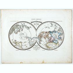
Composite atlas of the Low Countries.
A unique, made-to-order atlas comprising 18 double-page engraved maps by or after Hessel Gerritsz, Theodoor Galle, Jacob van Deventer, Gerard Mercator, Peter Verbiest, Je...
Date: [Antwerp, c. 1633
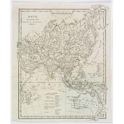
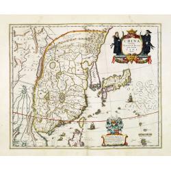
Asia, drawn from the latest Astronomical Observations.
This finely engraved, and detailed, map of Asia shows the extent of knowledge from astronomical observations at the time. It is also of interest for showing Australia her...
Date: London ca. 1808
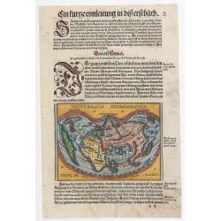
![Qua late patet S. Marci area major novum Regim Palatium versus. [Venice, piazza San Marco]](/uploads/cache/49400-250x250.jpg)
Qua late patet S. Marci area major novum Regim Palatium versus. [Venice, piazza San Marco]
View of piazza San Marco, the church of San Geminiano at the far end, figures and market stalls in the foreground.From the series "Prospectum Urbis Venetiarum" ...
Date: Venice, 1763

Carte du Golphe du Mexique et des Isles de l'Amerique.
Attractive map of the islands of the Caribbean that includes those parts of the United States & Mexico that border the Gulf of Mexico, Central America, and the northe...
Date: Paris, 1754

The Soviet Political Poster. - a portfolio collection of 32, full-color posters.
An attractive, large portfolio set of 32 reproductions published in Leningrad in 1976 by Aurora Art Publishers, containing various Soviet Union political posters from 191...
Date: Leningrad, Aurora Art Publishers, 1976
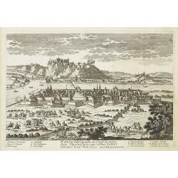
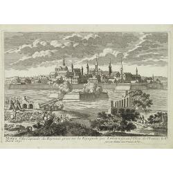
Namur Ville Capitale du Comté de même nom. Elle a este prise par le Roy LOUIS le Grand le 29e Juin 1692.
A very decorative and extremely rare town-view of Namur, including a numbered key (1-12) in the lower part. Engraved by Pierre-Alexandre Aveline. With "fait par Avel...
Date: Paris, ca.1692
Lugdunum vulgo Lyon.
SCARCE bird's-eye view of Lyon. Adorned with a title cartouche at bottom left, a cartouche at bottom right containing the legend with key tables 1-98 and three coats of a...
- $1000 / ≈ €861
Date: Amsterdam, ca. 1700
Seville ville Archiepiscopale et capitale du Royaume d'Andalousie en Espagne. . .
A very decorative and extremely rare town view of Seville, including a numbered key (1-37) in the lower part. Engraved by Pierre-Alexandre Aveline. With "fait par Av...
Date: Paris, ca.1692
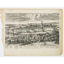
Mons ville capitale du Heynaut, prise sur les Espagnols par Louis le Grand Roy de France. . .
A very decorative and extremely rare town-view of Mons. Engraved by Pierre-Alexandre Aveline. With "fait par Aveline avec privilege du Roy" in lower right margi...
Date: Paris, ca.1692
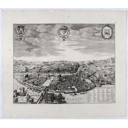
![Abbaye d'Hautecombe. [Hautecombe Abbey]](/uploads/cache/45509-250x250.jpg)
Abbaye d'Hautecombe. [Hautecombe Abbey]
Showing in great detail a bird's-eye view of the Hautecombe Abbey, a former Cistercian monastery, later a Benedictine monastery, in Saint-Pierre-de-Curtille near Aix-les-...
Date: Amsterdam, 1682
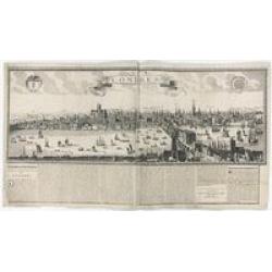
Londres 1678.
Extremely rare panoramic broad sheet panoramic town-view of London from Whitehall to the Tower, with underneath in letter press a description of the town's history. The o...
Date: Paris, 1677

(Publicity poster) Amer Besset Sans Rival.
Original chromo-lithographed in-store display for alcoholic drink Amer Besset. Printed by Joseph-Charles in Paris.
Date: Paris, ca.1933

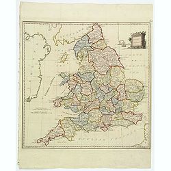
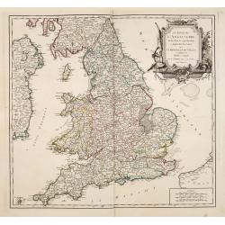
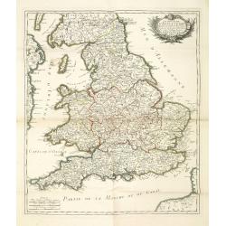
Bowles's new four-sheet map of England and Wales. . .
Bowles's new four-sheet map of England and Wales: Comprehending all the Cities, Boroughs, Market and Sea-Port Towns, Villages, Lakes, Rivers, Forests, Ruins, Canals, and ...
Date: London, 1801
Present Britain.
A fully colored map of England and Wales from An Universal Atlas Consisting of a Complete Set of Maps, peculiarly adapted to illustrate and explain ancient and modern geo...
Date: London, 1797

Carte de la Mer Rouge, depuis Moka jusqu's Gedda. . . .
Chart of the Red Sea. With 3 inset maps of Shake Omare, Goofs and Gedan. D'Après De Mannevillette (1707-1780) was one of France's first hydrographers. When the first edi...
Date: Paris, 1753

Les vallées du Piemont. Habitees par les Vaudois ou Berbets. . .
Detailed map of Piedmont region covering French and Italian territories. Surrounded by a French text description "Description des vallées du Piemont qu'habitent par...
Date: Paris, 1690

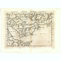
Arabia Felice Nuova Tavola.
Fine early map of Arabian peninsula, being one of the earliest modern maps of the region.Girolamo Ruscelli first published the map in his "La Geographi di Claudio To...
Date: Venice, 1561
Arabia Felice Nuova Tavola.
Fine early map of Arabian peninsula, being one of the earliest modern maps of the region.Girolamo Ruscelli first published the map in his "La Geographi di Claudio To...
Date: Venice, 1598
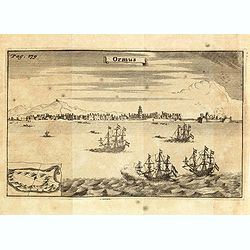
Ormus. (Hormuz)
This very interesting early engraving shows the ships of the Dutchman Van den Broecke, who in December 1628 left his directorship in Surat. Before returning to Batavia he...
Date: Amsterdam, F. Bernard, 1725

Arabia
A lovely miniature map the Arabian Peninsular, published by Petrus Bertius, and published in Amsterdam at the beginning of the seventeenth century. With an attractive s...
Date: Amsterdam, 1606
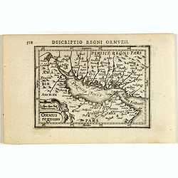
Descriptio Regni Ormuzii / Ormus.
A lovely miniature map of the Kingdom of Ormus, published by Petrus Bertius, and published in Amsterdam at the beginning of the seventeenth century. With an attractive st...
Date: Amsterdam, 1606
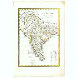
El Indostan por D. Juan Lopez.
Uncommon map of India and Shri Lanka published by Juan Lopez (1765-1830) and included in his "Atlas Universal o collection de mapas nuevos. . ." first published...
Date: Madrid, 1817
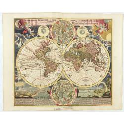
Planiglobii Terrestris Cum Utroq Hemisphaerio.
Vibrantly decorative world map surrounded by vivid engravings of natural phenomena such as waterspouts, a rainbow, earthquakes, and a volcano. Windheads occupy the starry...
Date: Nuremberg, c. 1720
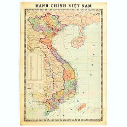
Hành Chính Việt Nam.
Uncommon map of Vietnam published in 1976, one year after the end of the Vietnam War. In April 1976, the National Assembly decided to reiterate Hanoi as the capital of th...
Date: Hanoï, 1976

Vue de l Hotel du Lord Maire, qui comprend la Façade, et le Cot' Occidental de Londres.
Shows the famous Lord Mayor's coach driving through London. The Lord Mayor's coach is famous for its role in the Lord Mayor's Show, which is one of the longest-establishe...
Date: Augsburg, 1750
Le Royaume D'Angleterre, divise selon les sept Royaumes ou Heptrachie des Saxons, avec La Principaute De Galles, et subdivisie en Shires ou Comtes…
Decorative map of British Isles divided into the 7 ancient Heptarchies of the Saxons and also showing the more modern counties or shires. With Rococo title cartouche. Eng...
Date: Paris, 1753
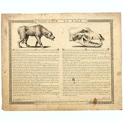
Notice sur la Rage.
Broad sheet etchings each with two vignettes and extensive descriptive text about rabies. Composed by François Chaussier and etched by L. Baltard. Francois Chaussier (17...
Date: Paris, ca. 1825
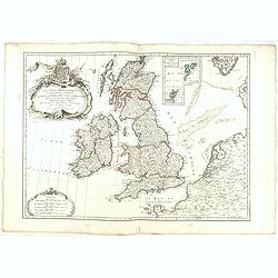
Les Isles Britanniques Comprenant les Royaumes D'Angleterre, D'Ecosse et D'Irlande divisée en grands provinces. . .
Detailed map encompassing present day British Isles. An inset in the upper right details the Shetland and Orkney Islands. Venetian edition of the map by Janvier, to whom ...
Date: Venice, 1776 - 1784
Le royaume d'Angleterre divise en comtez et baronnie. . .
Beautiful map of England, published by le Rouge.
Date: Paris,1745
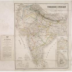
Vonder Indien.
Map of India with two inset maps, one of Upper Asam, and the other of Ceyland.
Date: Weimar, 1822-1825
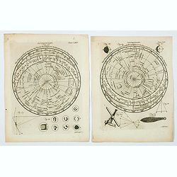
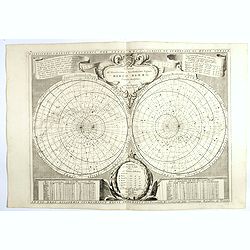
Astronomy. Figures 26 & 29. Plates LXV & LXV.
A lovely pair of copperplate astronomical plates displaying "The Principal fixed Stars in the North Hemisphere [and the South Hemisphere] Delineated on the Plane of ...
Date: London, 1792
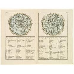
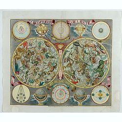
Planisphere ou Représentation du Globe Céleste en deux Plans Hémisphères Coupés par l'Ecliptique.
Representation of two celestial hemispheres with an exhaustive key list of constellations and main stars.From Atlas de la Géographie de toutes les parties du monde .. Ou...
Date: Paris, Prudhomme, Levrault, Debray, 1806
Planisferii Celesti, Calcolati Per L'Anno MDCC, Corretti, Et Aumenati Di Molte Stelle . . .
Double-hemisphere celestial map showing a new, more scientific depiction of the heavens. The remarkable Vincenzo Coronelli (1650-1718), was a Franciscan Friar and appoi...
Date: Venice, 1700
Planisphaerum coeleste.
A very decorative double hemisphere celestial chart. The 10 smaller circular diagram showing the rotation of the Planets, according to Tycho Brahe, Ptolemy and Copernicus...
Date: Nurenberg, 1750
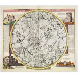
Hemisphaerium Coeli Australe in quo Fixarum. . .
Magnificent celestial chart drawn by the famous scientist Johann Gabriel Doppelmayr. Large circular charts of the southern hemisphere constellation, with decorative vign...
Date: Nuremberg, 1747
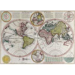
De Werelt Caart.
This is Cornelis Danckerts' second world map; his first being a re-engraved version of his father's map, published by Wetstein & Smith in Amsterdam and Luchtmans in L...
Date: Amsterdam, 1720
Mappamondo Carta d'Insieme.
Uncommon double hemisphere pole projection prepared by Francesco Costantino Marmocchi. Above the map "Geografia Commerciale". With a color code underneath the m...
Date: Genova, Paolo Rivara fu Giacomo, 1858
Universalis Cosmographia.
A very desirable cordiform (heart-shaped) world map from Johann Honter's 'Rudimentum'. The map is a reduced version of Waldseemüller's and Apianus' earlier world maps. T...
Date: Zurich, Froschauer, ca. 1546/1548
![[Figura del Mondo universale].](/uploads/cache/48963-250x250.jpg)
[Figura del Mondo universale].
Münster's map of the World is one of the most recognized world maps of the 16th Century. Italian text edition published in Cologne without the title. This example is fro...
Date: Arnold Birckmann heirs, Cologne, 1575
Nova Totius Terrarum Orbis Tabula.
Two hemispheres surrounded by six robust statuesque figures representing Day and Night and the four elements, each, except for Mother Earth, proudly unclothed. Subsequent...
Date: Amsterdam, 1688-1697
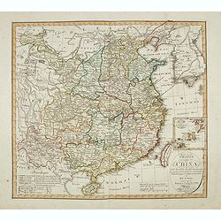
Charte von China nach Murdochischer Projection entworfen. ... Berichtiget, und gezeichnet von H.F.A. Stieler. . .
Uncommon map of China prepared by H.F.A.Stieler, with parts of Taiwan, Tibet, Mongolia and the Korean peninsula, with a great many place names, a key to (and brief explan...
Date: Weimar, 1804

Die Insel Formosa neu abgemessen auf Befehl Kaysers Kamhi.
One of the earliest obtainable printed maps of Taiwan or Formosa Island. It was issued around 1726 to illustrate Joseph Stöcklein's [Stoecklein] compilation of Jesuit mi...
Date: Augsburg, 1726

Fokien Imperii Sinarum Provincia undecima.
The province of Fokien lies opposite Taiwan and south of the region described in the above map. The coast is shown from Wen-zhou in the north to Fu-zhou and as far south ...
Date: Amsterdam, 1660

Chungguk-do
Chungguk-do [Map of China] taken from a Korean printed Ch’onha chido [Atlas of all under Heaven] which is a 19th century version of the traditional Korean atlas produce...
Date: Korea, ca. 1820

Xantung, sinarum imperii provincia quatra.
A map of the northern province ‘Xantung’ of China after the Jesuit Martino Martini.Shows the Great Wall and is centered on the Bohai Sea, and the Shandong and Liaonin...
Date: Amsterdam, ca 1660

Xantung, sinarum imperii provincia quatra.
A map of the northern province ‘Xantung’ of China after the Jesuit Martino Martini. Shows the Great Wall and is centered on the Bohai Sea, and the Shandong and Liaon...
Date: Amsterdam, ca 1660

Paradigma XV Provinciarum et CLV Urbium Capitalium Sinensis Imperij Cum Templis quae Cruce X Signatur Et Domiciliis S.I.
First edition of this rare Jesuit map of China, published by Jean Baptiste Nolin in Paris and based on Philippe Couplet's map of 1686. The map shows China's 15 provinces ...
Date: Paris, 1686

Pecheli, Xansi, Xantung, Honan, Nanking, In plaga Regni Sinensis. . .
A map of the northern provinces of China after the Jesuit Martino Martini, depicting Hebei (Pecheli), Shanxi (Xansi), Shandong (Xantung), Henan (Honan), and Jiangsu (Nank...
Date: Amsterdam, ca 1660

China Veteribus Sinarum Regio.
Based on Jesuit surveys, the map represents the next major revision in the cartography of China after Ortelius' 1584 map. Korea, however, is still an island, and Japan co...
Date: Amsterdam, 1640
China Veteribus Sinarum Regio.
This was the first of Blaeu's maps of China. In 1655 he was to publish the famous map of Father Martini, with many of the earlier inaccuracies present on this map correct...
Date: Amsterdam, 1653

Key Map of Hong Kong Relative to Canton and Macao.
A nice folded map of Hong Kong and the surrounding areas. Produced by the British Crown Lands Survey Office just after WWII. Physical features are shown by contour. Railw...
Date: Hong Kong, 1948
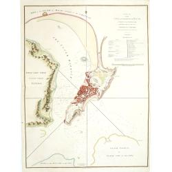
A Plan of the city and harbour of Macao : a colony of the Portugueze, situated at the southern extremity of the Chinese Empire. . .
A large chart of Macao engraved by Benjamin Baker (fl. 1766-1824) and published by George Nicol. The town of Macao is shown in detail, with a 37-point key in English list...
Date: London, 1796

Iunan, Queichev, e Quangsi Provincie della Cina. . .
A beautiful map depicting the area of Beijing with decorative title cartouche and scale cartouche. Information about the area at the top of the map.The remarkable Vincenz...
Date: Venice, 1690
Tabula chronologica historiae Sinicae connexa cum cyclo qui vulgo Kia Tse dictur.
A set of two sheets of colored copper engravings. First published in 1729 in Rome in three sheets. Timeline of China's history with a chronological overview of the dynast...
Date: Augsburg, 1746

Quantung, e Fokien, Provincie della China...
A beautifully engraved decorative map of Southern China extending from Hainan in the West to Formosa in the East and centered on the Pearl River Delta with Macao and the ...
Date: Venice, 1691
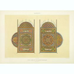
Arabesques. - Pages jumelles d'un qorân mauresque. (XVIIIe siècle)
Lithographed by Daumont. From the author's "L'Art Arabe d'après les monuments du Kaire…". Emile Prisse d'Avennes, an Orientalist and Muslim convert with obse...
Date: Paris, 1877
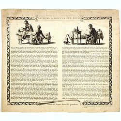
Secours à donner aux noyés.
Broad sheet etchings with two vignettes and extensive descriptive text about how to rescue a flooded person.Composed by François Chaussier and etched by L. Baltard. Fra...
Date: Paris, ca. 1825
![Voyage et conduite d'un moribond pour l'autre monde [Caricature Parisienne.]](/uploads/cache/46786-250x250.jpg)
Voyage et conduite d'un moribond pour l'autre monde [Caricature Parisienne.]
A 'busy', but sobering print depicting the procession of a dying old man to the afterlife. Attractively colored. Accompanying the old man on his inevitable journey are a ...
Date: Paris, 1820
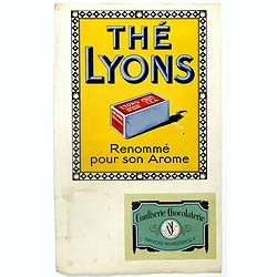
(Publicity.) Thé Lyons. Renommé pur son Arome.
Original chromolithography in-store display for Lyon's tea in Belgium and France. In 1902, the Lyons family started their little tea business on High Street in Dublin, ne...
Date: Paris, ca. 1935
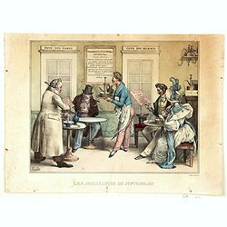
Les Jouissance du Juste Milieu.
[The Joys of the Happy Medium.] A waiter is about to serve a customer with a clyster pump and water jug. It looks as though the man has a 'menu' in one hand. On another t...
Date: Paris, ca 1820
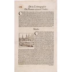
Meche.
Panoramic view of Mecca from Antoine du Pinet's "Plantz, Pourtraitz, Et descriptions De Plusieurs Villes". Woodblock print in text leaf with an interesting desc...
Date: Lyon, 1564
![[Arabia]](/uploads/cache/40143-250x250.jpg)
[Arabia]
A lovely miniature map of the region of Armenia and Georgia, showing both parts of the Black Sea and Caspian Sea. For such a small map, it renders a wealth of detail, wit...
Date: Ulm, 1692
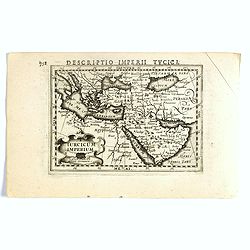
Turicum imperium.
FIRST IMPRINT FROM THE NEWLY ENGRAVED PLATES IN 1616. - A rare miniature map of the Ottoman empire with Turkey and the Arabian Peninsular. Title cartouche on the lower le...
Date: Amsterdam, J. Hondius, 1616

Ormus (Straits of Hormus)
A lovely miniature map of the Kingdom of Ormus, published by Petrus Bertius, and published in Amsterdam at the beginning of the seventeenth century. With an attractive st...
Date: Amsterdam, 1606
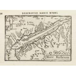
Mare Rubrum.
Very fine miniature map including the Red Sea, Yemen, east coast of the Arabian peninsula. One of the early maps to focus on this area.Engraved by Petrus Kaerius.More abo...
Date: Amsterdam, 1602

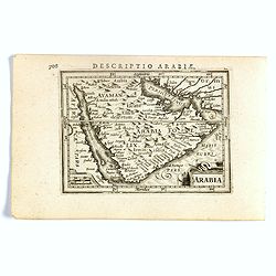
Descriptio Arabie / Arabia.
A rare miniature map of the Arabian Peninsular. The title cartouche on the lower right corner.First published in 1598 in his Caert-Thresoor, the plates were executed by t...
Date: Amsterdam, Cornelis Claes, 1606
Arabia.
FIRST IMPRINT FROM THE NEWLY ENGRAVED PLATES IN 1616. - A rare miniature map of the Arabian Peninsular. Title cartouche on the lower left corner.First published in 1598 i...
Date: Amsterdam, J. Hondius, 1616
Nieuwe kaart van Arabia.
Here is an attractive map of the Arabian Peninsula, Gelukkig Arabia or Happy Arabia. The map is a great advance on other maps of the time by showing the true extent of...
Date: Amsterdam, 1740
Carta nuova dell'Arabia.
Detailed map of Arabia and environs. Based on a map published by Isaak Tirion in Amsterdam, but here issued by Albrizzi with a modified title.More about Mapping of Arabia...
Date: Venice, 1740
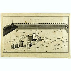
Le Temple de la Mecque.
Striking view of the Temple at Mecca, showing the Kaaba at the center of Islam's most sacred mosque, that is Al-Masjid Al-?aram, in Mecca, Hejaz, Saudi Arabia.The engravi...
Date: The Hague, Isaac Vaillant, 1721

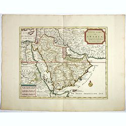
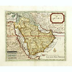
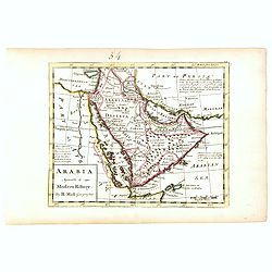
Arabia. Sive Regio inter Mare Medium, Arabicum Sinum, . . .
Very detailed map of the Arabian Peninsular, covering the Caspian Sea in the upper right corner and Syria to the Indian Ocean, Somalia and parts of Persia, Syria and Kurd...
Date: London, 1841

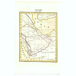
L'Arabie.
Small detailed map of the Arabian Peninsula. From Atlas Portatif Universel, by Robert de Vaugondy.Page 162 outside border top right.
Date: Paris, later than 1749
Arabie par A.M. Perrot.
Uncommon map of Arabia, prepared by A.M. Perrot and engraved by P Tardieu.More about Mapping of Arabia [+]
Date: Paris, 1835
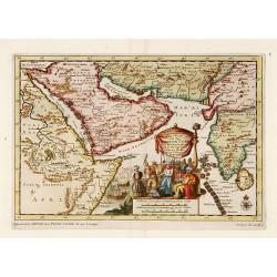
Zee-Togt van den Grooten Turk Uyt het Roode Meyr Tegen de Portugy fen na Indien tot aan Kaap Comorin Ondernomen.
Map of the Arabian peninsula, with Saudi Arabia, the Indian Ocean and India and Ceylon.Although not renowned for the originality of his work, Pieter van der Aa is highly ...
Date: Leiden, 1706
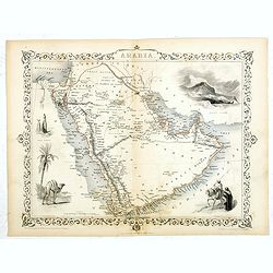
Arabia.
A highly decorative and detailed map of Arabia, drawn and engraved by J.Rapkin and the Illustrations by H. Warren after J. Rogers.Taken from "The illustrated atlas a...
Date: London / New York: John Tallis & co, c.1851
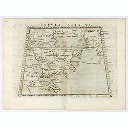
Tabula Asiae VI.
Uncommon first edition of this classical map of the Arabian Peninsular, is an enlarged version of Giacomo Gastaldi's published in 1548Girolamo Ruscelli's edition of Ptole...
Date: Venice, 1561

Carte Particuliere d'une Partie d'Asie ou sont Les Isles D'Andemaon, Ceylan, Les Madives . . .
An impressive large sheet chart including the Red Sea, the coasts of Somali, Yemen, east coast of the Arabian peninsula. One of the early maps to focus on this area. Nume...
Date: Amsterdam, 1720
Arabia agreeable to Modern History.
Detailed map of the Arabian Peninsula from the Mediterranean Sea to the Arabian Sea, and western Iran. with an engaging text block on upper right corner: "Arabia, d...
Date: London, 1739
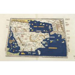
Tabula Sexta Asia (Arabian Peninsula)
This is a very desirable early Ptolemaic woodblock map of the Arabian Peninsula, here called Arabia Felix. The map is presented on a trapezoidal projection with paralle...
Date: Strassburg, 1525
![[Arabian Peninsula]](/uploads/cache/33869-250x250.jpg)
[Arabian Peninsula]
Wood block printed map and one of earliest printed representation of the Arabian Peninsula prepared by Martin Waldseemüller. Based on the slightly larger map from 1513 p...
Date: Vienna, Trechsel, G., 1525 -1541
