Browse Listings
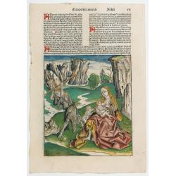
Prima Etas Mundi. IX
A very fine presentation of Eve nursing Kain and Abel. Adam is working (255x220 cm). VERSO: A Genealogy of Adam.Page from the richest illustrated Incunabel, the famous L...
Date: Nuremberg, 12 July 1493
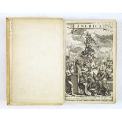
De Nieuwe en Onbekende Weereld: of Beschryving van America en 't Zuid-Land.
FIRST EDITION. "This is a classic book on America and is much sought after by collectors of Americana as it contains, on p. 124, one of the first views of New York N...
Date: Amsterdam, Jacob Meurs, 1671

A Map of the British Empire in AMERICA with the French, Spanish and Hollandish Settlements Adjacent Thereto. by Henry Popple. / Nouvelle Carte Particuliere de L'Amerique . . .
The four sheet Dutch edition of Popple's monumental map of North America, in mint condition. Encompassing the West Indies, Florida, Louisiana, Texas and Central America.T...
Date: Amsterdam, ca. 1737
![[Lower half] Amerique Septentrionale avec les Routes, Distances en miles, Limites et Etablissements François et Anglois Par le Docteur Mitchel Traduit de 'Anglois..](/uploads/cache/49378-250x250.jpg)
[Lower half] Amerique Septentrionale avec les Routes, Distances en miles, Limites et Etablissements François et Anglois Par le Docteur Mitchel Traduit de 'Anglois..
This is the important 1777 French edition by Georges Le Rouge of the seminal John Mitchell map of eastern North America. The Mitchell map is considered the single most im...
Date: Paris, 1777

French composite atlas made up of rare maps published by Parisian editors from the 17th century , mainly by G. Jollain including scarce maps of America.
A rare French composite atlas including 90 maps, published by Parisian publishers from the 17th century, mainly by Gérard I Jollain, or by maps bought from Dutch publish...
Date: Paris, ca. 1675
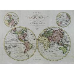
Karte der Erde, nach ihrer oestlich, westlich, noerdlich und südlichen Halbkugel, aus den zuverlässigsten u. neuesten Nachrichten entworfen 1803.
Uncommon and detailed world map in double hemisphere. In upper corners insets of North- and South Pole projections. Detailed outline for Australia and New Zealand.
Date: Augsburg, 1803
![[Set of five maps] Carte Generale de la Terre ou Mappe Monde avec les Quatres Principaux Sistemes . . . 1776 (with) Carte D'Amerique ... (and) Carte D'Afrique . . . (and) Carte d'Asie) (and) Carte D'Europe . . . 1776](/uploads/cache/41145X-250x250.jpg)
[Set of five maps] Carte Generale de la Terre ou Mappe Monde avec les Quatres Principaux Sistemes . . . 1776 (with) Carte D'Amerique ... (and) Carte D'Afrique . . . (and) Carte d'Asie) (and) Carte D'Europe . . . 1776
Rare and decorative set of five wall maps of the world and the four continents, prepared by Clouet, in very fine, bright contemporary coloring. Each map ca. 965 x 1230 mm...
Date: Paris and Cadiz, Mondhare, 1776
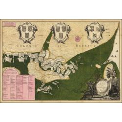
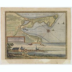
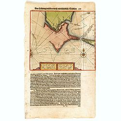
Naaukeurige Platte Grond van den Staat en den Loop van Rio de Berbice Met derzelver Plantagien in de Geoctrojeerde Colonie de Berbice Gelegen. . .
Uncommon large-scale map of Berbice with Rio de Berbice and Rio de Canje, with at the bottom left a list of plantation owners. In the top 3 x 3 coats of arms in cartouche...
Date: Amsterdam, 1740

Two sheets for constructing an armillary sphere.
Two sheets for constructing an armillary sphere. Cassini was a geographer and cartographer, but also perspective and architecture carver - one of Giovanni Battista Pirane...
Date: Rome, 1795

A new and correct map of the world.
The early eighteenth century was one of the most important periods for English cartography. One of the period's most intriguing world maps is this large-scale map, which ...
Date: London 1714

World Flight Routes (all in Japanese).
A large, very decorative Japanese world map published as sugoroku (a Japanese game which might be compared to backgammon), published as a supplement to the 1930 New Year�...
Date: Osaka, 1930
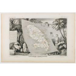
Colonies Françaises. Martinique - Amérique du Sud.
Carte du Département de la Martinique entourée de motifs décoratifs représentant les productions de l'île telles que le tabac et le sucre. In original o.l. color, f...
Date: Paris, 1854
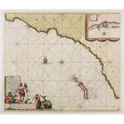
Nieuwe Pascaert vande Kust van Maroca en Zanhaga beginnend van C. Cantin tot C. Bajador, waer in ook te sien is 't I. Lancerota en 't I. Forteventura. . .
A very fine sea chart of the west coast of Morocco between C. Cantin to C. Bajador and the Canary Islands, Lanzarote and Fuerteventura. With a very large decorative title...
Date: Amsterdam, 1700
A Chart, on Mercator's Projection, Containing the Track and Soundings of the Lion, the Hindostan and Tenders, from Turon-Bay in Cochin-China. . .
A chart engraved by Baker and published by Nichol, this large chart traces the routes of the Lion, Hindostan, and Tenders with considerable detail. The chart was part of ...
Date: London, 1796
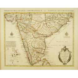
Carte des Côtes de Malabar et de Coromandel Presentée au Roy. . .
Large and attractive map of the Indian coasts of Malabar and Coromandel, embellished with title cartouche and 2 compass roses. It shows the most northern part of Ceylon.T...
Date: Amsterdam c. 1745
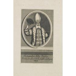
Tschanibei Ally Bassa. Türckischer Gross-Böthschafter um Kayserl.
Engraving by Johann Martin Bernigeroth (1713-1767) showing a full portrait of the Turkish ambassador in Vienna Ally Bassa.
Date: Leipzig, c. 1750
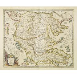
Macedonia, Epirus et Achaia.
Nice map of northern Greece with the southern parts of present day Macedonia and Albania. Includes the region of Athens. Strapwork title cartouche and Spanish text on ver...
Date: Amsterdam, 1650
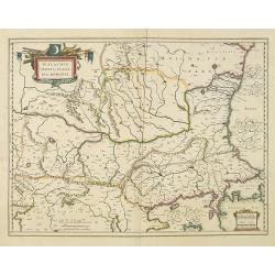
Walachia, Servia, Bulgaria, Romania.
Striking map of the region centered on the Lower Danube, Bulgaria, Romania, Serbia and Macedonia. Includes decorative cartouche, coat of arms, etc. Latin text on verso.Th...
Date: Amsterdam, 1638

POLONIAE finitimarumque locorum descrip:tio. Auctore WENCESLAO GRODECCIO. Polono.
Ortelius' map of Poland, being a close copy of Grodecki / Pograbka's map of 1558/62 map, itself based on Wapovsky 1526 (Karrow 56) With Latin text on verso, a state 4 and...
Date: Antwerp, 1592
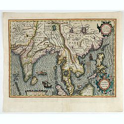
India Orientalis.
Published in Hondius' editions of the Mercator Atlas from 1606 onwards, showing the Indian subcontinent, the Malay Peninsula, Siam and Cambodia, China and the Philippines...
Date: Amsterdam, 1630
![[Manuscript] Plan du siege de la forteresse d'Oczakow avec les détails... aux ordres du Prince Potemkin, le 17 Decemb: 1788.](/uploads/cache/34599-250x250.jpg)
[Manuscript] Plan du siege de la forteresse d'Oczakow avec les détails... aux ordres du Prince Potemkin, le 17 Decemb: 1788.
Very detailed well executed manuscript plan of the Turkish Fortress Ochakov captured by Russian Troops on December 17, 1788 by the Maréchal Prince Potemkin. In lower lef...
Date: ca. 1788
Neoburgum Fioniae oppidum. . .
Decorative plan and panoramic view of the town of Nyborg in Denmark at the coast of Baltic Sea in Fyn. Prepared by Count Erik Jönsson Dahlberg[h] (1625-1703). Military e...
Date: Stockholm, 1697
![Carthage, etc. [Foliu XL ] Carthage in Tunisia](/uploads/cache/26122-250x250.jpg)
Carthage, etc. [Foliu XL ] Carthage in Tunisia
VERSO: Portraits of scholars, and an imaginary view on Carthage in Tunisia (12x17cm.) Page from the famous Liber chronicarum of Hartmann-Schedel 1493, the first and Latin...
Date: Nuremberg 12 July 1493
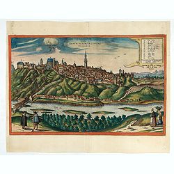
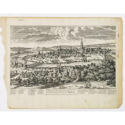
Znaymum vulgo Znaym, Moraviae Civitas Primaria.
Rare bird's-eye view of Znojmo (Znaim). A key to 12 locations.COMMENTARY BY BRAUN: "This is a beautiful and wealthy city in Moravia, situated on the border to Austri...
Date: Cologne, 1618
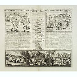
Genealogie des anciens empereurs mogols,. . .
Text sheet with two inset maps of "Carte de l'empire du grand Mogol (122x158mm.) and inset map of Kahsmire "carte nouvelle du royaume de Kachemire" (120x15...
Date: Amsterdam, 1728
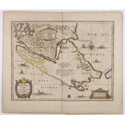
Freti Magellanici ac novi Freti vulgo Le Maire. . .
A fine map of Tierra del Fuego. With an explanatory text of the passage by Barent Jansz. Potgieter, who accompanied Captain Sebald de Weert to the Straits in 1599/1600, w...
Date: Amsterdam, ca. 1633
Caarte vande nieuwe Passagie bezuijden de Strate Magellan. . . / Description de nouveau passage vers le zud du destroit de Maggellan. . .
Map showing the new route around the bottom of South America discovered by Schouten and Le Maire: through the Le Maire Strait, around the Barnevelt Islands, and past Cape...
Date: Frankfurt am Main, 1619
Sudseite des Landts Terza del Fuoco, abgezeichnet durch Iohan von Walbeck.
Map showing Cap Horn and the Terra del Fuego.From a German text edition of Theodor de Bry's travel book. The original copper plate is now shortened at the left side and h...
Date: Frankfurt am Main, 1630

Magnae Prussiae Ducatus Tabula denuo correcta et in lucem edita per Nicolaum Visscher.
Striking old color example of Visscher's map of Prussia and part of the Baltic region. Includes a gorgeous cartouche and banner key held aloft by 2 cherubs, plus 4 sailin...
Date: Amsterdam, 1690
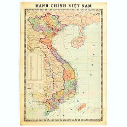
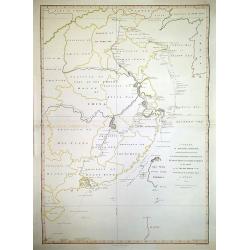
Hành Chính Việt Nam.
Uncommon map of Vietnam published in 1976, one year after the end of the Vietnam War. In April 1976, the National Assembly decided to reiterate Hanoi as the capital of th...
Date: Hanoï, 1976
![Chinese advertising poster [ Liae divison public specialized into the middle age of China.]](/uploads/cache/45085-250x250.jpg)
Chinese advertising poster [ Liae divison public specialized into the middle age of China.]
This poster, an advertisement from the 1930s, melds the meticulous detail of traditional Chinese painting with the craft of color lithography. It depicts a beautiful woma...
Date: Shanghai, 1950-1960

Chinese advertising poster.
This poster, an advertisement from the 1930s, melds the meticulous detail of traditional Chinese painting with the craft of color lithography. It depicts a young woman dr...
- $100 / ≈ €86
Date: Shanghai, 1950/1960

The picture of Hong tao Carpet garden
This poster, an advertisement from the 1930s, melds the meticulous detail of traditional Chinese painting. It depicts a young woman posing. Google Translate: "Americ...
- $100 / ≈ €86
Date: Shanghai, 1950/1960
![[ Original Chinese advertising poster for ] [Google translate: Vendor Yiwei Shikou Supervisor Store Baishun Chengyan]](/uploads/cache/45082-250x250.jpg)
[ Original Chinese advertising poster for ] [Google translate: Vendor Yiwei Shikou Supervisor Store Baishun Chengyan]
This poster, an advertisement from the 1930s, melds the meticulous detail of traditional Chinese painting with the craft of color lithography. It depicts a beautiful woma...
Date: Shanghai, 1950/1960

Chinese advertising poster for the Jintan cigarette brand.
This poster, an advertisement for the Jintan Cigarettes brand from the 1930s, melds the meticulous detail of traditional Chinese painting with the craft of color lithogra...
Date: Shanghai, 1950/1960

Chinese advertising poster for Hataman cigarette brand.
This poster, an advertisement for Hataman Cigarettes from the 1930s, melds the meticulous detail of traditional Chinese painting with the craft of color lithography. It d...
Date: Shanghai, 1950/1960

Chinese advertising poster for the Coat Clark British company.
This poster, an advertisement for Coat Clark, a British company from the 1930s, melds the meticulous detail of traditional Chinese painting with the craft of color lithog...
Date: Shanghai, 1950-1960

Chinese advertising poster for Red Lion cigarette brand.
This poster, an advertisement for the Red Lion Cigarettes brand from the 1930s, melds the meticulous detail of traditional Chinese painting with the craft of color lithog...
Date: Shanghai, 1950/1960

Chinese advertising poster for Hataman cigarette brand.
This poster, an advertisement for Hataman Cigarettes from the 1930s, melds the meticulous detail of traditional Chinese painting with the craft of color lithography. It d...
- $100 / ≈ €86
Date: Shanghai, 1950-1960

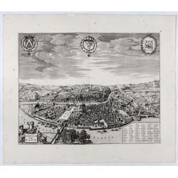
Composite atlas of the Low Countries.
A unique, made-to-order atlas comprising 18 double-page engraved maps by or after Hessel Gerritsz, Theodoor Galle, Jacob van Deventer, Gerard Mercator, Peter Verbiest, Je...
Date: [Antwerp, c. 1633
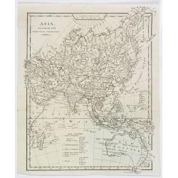
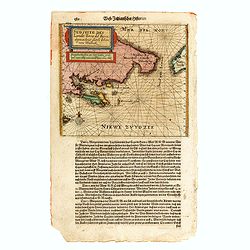
Asia, drawn from the latest Astronomical Observations.
This finely engraved, and detailed, map of Asia shows the extent of knowledge from astronomical observations at the time. It is also of interest for showing Australia her...
Date: London ca. 1808

Carte du Golphe du Mexique et des Isles de l'Amerique.
Attractive map of the islands of the Caribbean that includes those parts of the United States & Mexico that border the Gulf of Mexico, Central America, and the northe...
Date: Paris, 1754

The Soviet Political Poster. - a portfolio collection of 32, full-color posters.
An attractive, large portfolio set of 32 reproductions published in Leningrad in 1976 by Aurora Art Publishers, containing various Soviet Union political posters from 191...
Date: Leningrad, Aurora Art Publishers, 1976
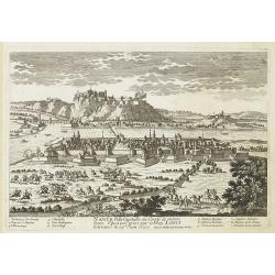
Namur Ville Capitale du Comté de même nom. Elle a este prise par le Roy LOUIS le Grand le 29e Juin 1692.
A very decorative and extremely rare town-view of Namur, including a numbered key (1-12) in the lower part. Engraved by Pierre-Alexandre Aveline. With "fait par Avel...
Date: Paris, ca.1692
Lugdunum vulgo Lyon.
SCARCE bird's-eye view of Lyon. Adorned with a title cartouche at bottom left, a cartouche at bottom right containing the legend with key tables 1-98 and three coats of a...
- $1000 / ≈ €861
Date: Amsterdam, ca. 1700
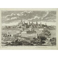
Seville ville Archiepiscopale et capitale du Royaume d'Andalousie en Espagne. . .
A very decorative and extremely rare town view of Seville, including a numbered key (1-37) in the lower part. Engraved by Pierre-Alexandre Aveline. With "fait par Av...
Date: Paris, ca.1692
Mons ville capitale du Heynaut, prise sur les Espagnols par Louis le Grand Roy de France. . .
A very decorative and extremely rare town-view of Mons. Engraved by Pierre-Alexandre Aveline. With "fait par Aveline avec privilege du Roy" in lower right margi...
Date: Paris, ca.1692
![Abbaye d'Hautecombe. [Hautecombe Abbey]](/uploads/cache/45509-250x250.jpg)
Abbaye d'Hautecombe. [Hautecombe Abbey]
Showing in great detail a bird's-eye view of the Hautecombe Abbey, a former Cistercian monastery, later a Benedictine monastery, in Saint-Pierre-de-Curtille near Aix-les-...
Date: Amsterdam, 1682
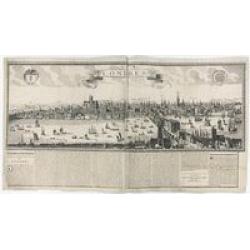
Londres 1678.
Extremely rare panoramic broad sheet panoramic town-view of London from Whitehall to the Tower, with underneath in letter press a description of the town's history. The o...
Date: Paris, 1677

(Publicity poster) Amer Besset Sans Rival.
Original chromo-lithographed in-store display for alcoholic drink Amer Besset. Printed by Joseph-Charles in Paris.
Date: Paris, ca.1933
