Sign In or Sign Up
1575 MÜNSTER, S. - Münster's map of the World is one of the most recognized world maps of the 16th Century

[Figura del Mondo universale]. |
||||||||||||||||||||
|
||||||||||||||||||||
|
|
||||||||||||||||||||
$3500 / ≈ €3113This item is available for immediate sale! Questions before Buying ?
We are happy to answer your questions. |
My Collection +
Add this or any of your favorite items in one place. If you want to save the items permanently, you have to sign in or create an account first.   Add/Remove |
|||||||||||||||||||



Description
Münster's map of the World is one of the most recognized world maps of the 16th Century. An Italian-text edition published in Cologne without the title. This example is from the second woodblock, which includes the engraver David Kandel's initials. The map is richly embellished with sea monsters and 12 wind heads.
The example offered here is the second edition of the map, which appeared in Munster's Cosmographia beginning in 1550.
The map is based upon a mix of information derived from Verrazano's explorations (1522-24), which mistook the Chesapeake for the Indian Ocean, and Cartier's voyages (1534-35) up the St. Lawrence in search of the Northwest Passage. The west coast of America appears on the right side of the map. This is also the 1st map to name the Pacific Ocean (Mare Pacificum).
Munster is non-committal as to the continuity of North and South America, an unbroken Central America being implied but not clearly shown. Though unnamed, Terra Australis is present but small, only serving to form the Magellan Strait.
All of North America is called Terra Florida. Munster here adds further to the current confusion over Taprobana and Ceylon, depicting a Sumatra-shaped Taprobana on the west side of the Indian subcontinent, and Java in the approximately correct size and position of Sri Lanka.
This second edition, from a new woodblock, featured in editions of the Cosmographia from 1550. All of these editions were printed in Basel, except for two Italian editions printed in Venice (1571) and Cologne (1575) that used the same block. The map featured in the following editions:
- 1550 Latin and German
- 1552 Latin and French
- 1553 German
- 1554 Latin
- 1556 German and French
- 1558 German and Italian
- 1559 Latin
- 1560 French
- 1561 German
- 1564 French
- 1567 German
- 1568 French
- 1569 German
- 1571 Italian (Venice)
- 1572 German and Latin
- 1574 German
- 1575 Italian (Cologne)
- 1578 German
The Basel editions from 1588 onwards contain a new world map, published by Sebastian Petri. Petri was the son of Heinrich Petri, Münster’s son-in-law and publisher of the Cosmographia from 1552.
Reference: Burmeister, Sebastian Münster, # 101
Sebastian Münster (20 January 1488 - 26 May 1552)
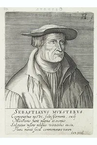 A German cartographer, cosmographer, and Hebrew scholar. He was born in Niederingelheim, near Mainz, where Johannes Gutenberg invented movable-type printing in the 1460s. In 1505, Münster became a Franciscan monk and studied philosophy and theology at the order's university in Heidelberg. He produced his own edition of Ptolemy's Geographia in 1540, adding several significantly new maps to the modern section of the work. There were further editions of the Geographia in 1541, 1542, 1545 and 1552. All were printed in Basel in Latin.
His two major works, the Geographia and the Cosmographia, continued to be published by his stepson, Heinrich Petri, long after Munster's death from the plague in 1552. Later editions of Munster's Cosmographia included updated maps.
He wrote grammars, dictionaries and a Hebrew Bible with a Latin translation (1534–35), which made him well known across Europe.
He is also known for his writings on mathematics and astronomy. His treatises on sundials, instruments, and mathematics reflect his training in Tübingen.
He is known for:
- His early maps of Germany. From the late 1520s, he surveyed and mapped the German lands, relying on friends and local scholars for data.
- Ptolemy's Geographia (Basel, 1540). An edition that combined the classical Ptolemaic maps with new maps of the modern world, showing the continents as they were then understood.
- The Cosmographia (first edition 1544).
He is best known for his Cosmographia
First published in German in Basel by Heinrich Petri in 1544, the Cosmographia described every known region of the world: its geography, peoples, customs, history, natural wonders, and cities. Münster gathered material from classical and contemporary authors and also asked scholars, officials and travelers across Europe to contribute descriptions and views of their own regions, an early example of crowd-sourced scholarship.
The work was extraordinarily successful. The book appeared in more than forty editions between 1544 and 1650, in German, Latin, French, Italian, Czech and an abridged English version. His successors later enlarged editions, so the book's content changed considerably over the century.
FAQ - Guarantee - Shipping
This item is available for immediate purchase when a "Add to Cart" or "Inquire Now" button is shown.
Items are sold in the EU margin scheme
Payments are accepted in Euros or US Dollars.
Authenticity Guarantee
 We provide professional descriptions, condition report (based on 45 years experience in the map business)
Paulus Swaen warrants the authenticity of our items and a certificate of authenticity is provided for each acquired lot.
Condition and Coloring
We indicate the condition of each item and use our unnique HiBCoR grading system in which four key items determine a map's value: Historical Importance, Beauty, Condition/Coloring and Rarity.
Color Key
We offer many maps in their original black and white condition. We do not systematically color-up maps to make them more sellable to the general public or buyer.
Copper engraved or wood block maps are always hand colored. Maps were initially colored for aesthetic reasons and to improve readability. Nowadays, it is becoming a challenge to find maps in their original colors and are therefor more valuable.
We use the following color keys in our catalog:
Original colors; mean that the colors have been applied around the time the map was issued.
Original o/l colors; means the map has only the borders colored at the time of publication.
Colored; If the colors are applied recently or at the end of the 20th century.
Read more about coloring of maps [+]
Shipping fee
A flat shipping fee of $ 30 is added to each shipment by DHL within Europe and North America. This covers : International Priority shipping, Packing and Insurance (up to the invoice amount).
Shipments to Asia are $ 40 and rest of the world $50
We charge only one shipping fee when you have been successful on multiple items or when you want to combine gallery and auction purchases.
Read more about invoicing and shipping
FAQ
Please have a look for more information about buying in the BuyNow gallery
Many answers are likely to find in the general help section.
My Collection+

With My Collection+ you can collect all your favorite items in one place. It is free, and anyone can create his or her virtual collection.
Unless you are logged in, the item is only saved for this session. You have to be registed and logged-in if you want to save this item permanently to My Collection+. Read More[+]
Register here, it is free and you do not need a credit card.
Add this item to My Collection+ or click the following link to see My Collection+.
|
Digital Image Download Paulus Swaen maintains an archive of most of our high-resolution rare maps, prints, posters and medieval manuscript scans. We make them freely available for download and study. Read more about free image download |
Click the image for a free small image download. |


YOUR RIGHT TO CANCEL THE PURCHASE OF A LOT
In accordance with the EU Consumer Rights Directive and habitually reside in the European Union you have the right to cancel the contract for the purchase of a lot, without giving any reason.
The cancellation period will expire 14 calendar days from the day after the date on which you or a third party (other than the carrier and indicated by you) acquires, physical possession of the lot. To exercise the right to cancel you must inform Paulus Swaen Inc, of your decision to cancel this contract by a clear statement (e.g. a letter sent by post, or e-mail.
To meet the cancellation deadline, it is sufficient for you to send your communication concerning your exercise of the right to cancel before the cancellation period has expired.
Recently Viewed

[Figura del Mondo universale].
1575 MÜNSTER, S. - Münster's map of the World is one of the most recognized world maps of the 16th Century
Date: Arnold Birckmann heirs, Cologne, 1575
