Browse Listings
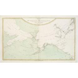
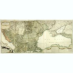
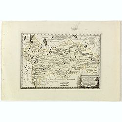
Karte von den N.W. Amerikanischen und N.OE. Asiatischen Kusten nach den Untersuchungen des Kapit. Cook...
A detailed large-scale map showing the Bering Strait, Kamchatka, Alaska and much of North America. While the Russian coastline is shown with reasonable accuracy. Showin...
- $450 / ≈ €389
Date: Vienna, 1788

L'Amérique divisée en ses principaux Etats Dressée d'après les Cartes de Mr. Bonne. . .
Rare, wall map of America in 2 sheets, after R. Bonne. With 3 inset maps of Hispaniola, Martinique and Hudson Bay. Beautiful title cartouche depicting a Native American l...
Date: Paris, 1788
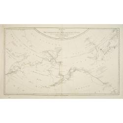
Karte von den N.W. Amerikanische und N.O.E. Asia. . .
German edition of Cook's explorations along the NW Coast of America and NE Coast of Asia, based upon the original work by Lieutenant Henry Roberts.A detailed large-scale ...
- $400 / ≈ €346
Date: Vienna, 1788
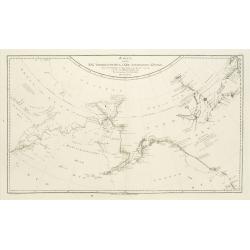
Karte von den N.W.Amerikanische und N.O.E. Asia..
A detailed large-scale map showing the Bering strait, Kamchatka, Alaska, and much of North America. While the Russian coastline is shown with reasonable accuracy. Showing...
Date: Vienna 1788
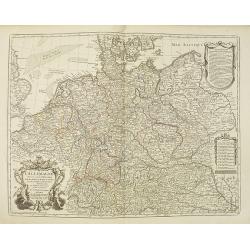
L'Allemagne dressée sur les observations. . .
Map of Germany, Low Countries, Poland, Switzerland, Northern Italy. Prepared by G.De L'Isle after observations by Kepler and Tycho Brahe.Engraved by Jean Batiste Liébaux...
- $300 / ≈ €260
Date: Paris, 1788
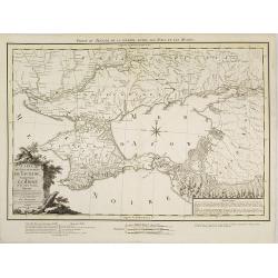
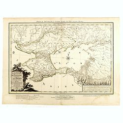
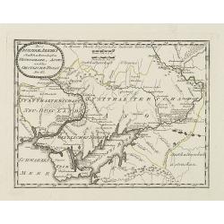
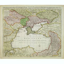
Carte du Gouvernement de Tauride, comprenant la Krimée et les pays voisins: dressée principalement d'après la carte faite sur les lieux pour le voyage de S.M. l'impératrice de Russie. . .
Very rare map of the Crimea area published Jean-Claude Dezauche, who was active in Paris 1770-1824. The map includes borders and a road system.Dezauche is giving credit t...
- $850 / ≈ €736
Date: Paris, 1788
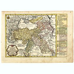
Kriegstheater oder Graenzkarte Oesterreichs, Russlands, und der Türkey. . .
Map of the theatre of war in the Balkans, Ukraine and around the Black Sea, indicating the Austrian, Russian and Turkish spheres of influence. Printed on two sheets and j...
Date: Artaria und Compagnie, Vienna, 1788
![[Manuscript] Plan du siege de la forteresse d'Oczakow avec les détails... aux ordres du Prince Potemkin, le 17 Decemb: 1788.](/uploads/cache/34599-250x250.jpg)
[Manuscript] Plan du siege de la forteresse d'Oczakow avec les détails... aux ordres du Prince Potemkin, le 17 Decemb: 1788.
Very detailed well executed manuscript plan of the Turkish Fortress Ochakov captured by Russian Troops on December 17, 1788 by the Maréchal Prince Potemkin. In lower lef...
- $2000 / ≈ €1731
Date: ca. 1788
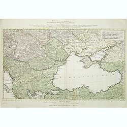
Carte du Gouvernement de Tauride, comprenant la Krimée et les pays voisins: dressée principalement d'après la carte faite sur les lieux pour le voyage de S.M. l'impératrice de Russie. . .
Rare map of southern Ukraine and the Crimea during the Second Russo-Turkish War (1787-92). Antique map of the Crimea during the Second Russo-Turkish War (1787-92), fought...
- $2500 / ≈ €2164
Date: Paris, 1788

Femme Samoyeds.
Originally hand-colored mezzotint from 'Costumes civils actuels de tous les peuples connus', showing a woman and child from Samojedin, Siberia in Russia. Engraved after J...
- $30 / ≈ €26
Date: M. Sylvain Maréchal. Paris, 1788
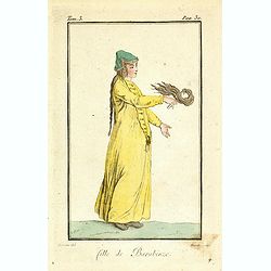
Fille de Barabinze.
Originally hand-colored mezzotint from 'Costumes civils actuels de tous les peuples connus', showing a girl from Barabinze in Siberia, Russia engraved by Félix Mixelle a...
- $30 / ≈ €26
Date: M. Sylvain Maréchal. Paris, 1788
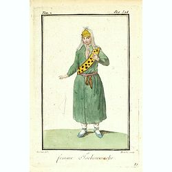
Femme Tschouwache.
Originally hand-colored mezzotint from 'Costumes civils actuels de tous les peuples connus' engraved by Félix Mixelle and Lachaussée Jeune after Jacques Grasset de Sain...
- $30 / ≈ €26
Date: M. Sylvain Maréchal. Paris, 1788

Femme Persienne.
Originally hand-colored mezzotint of a Persian woman engraved by Félix Mixelle and Lachaussée Jeune after Jacques Grasset de Saint-Sauveur.As an etcher, drawer and writ...
- $40 / ≈ €35
Date: M. Sylvain Maréchal. Paris, 1788
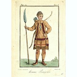
Homme Toungouse.
Originally hand-colored mezzotint from 'Costumes civils actuels de tous les peuples connus'. Engraving of a man dressed in native garb from the Tunguska region of norther...
- $25 / ≈ €22
Date: M. Sylvain Maréchal. Paris, 1788
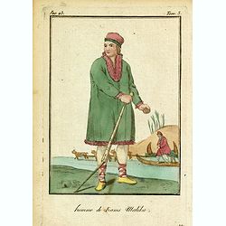
Homme de Kams Malika.
Originally hand-colored mezzotint from 'Costumes civils actuels de tous les peuples connus'. Showing a man from Russia, by M. Sylvain Maréchal. Paris, 1788.As an etcher,...
- $25 / ≈ €22
Date: M. Sylvain Maréchal. Paris, 1788
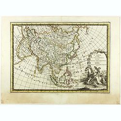
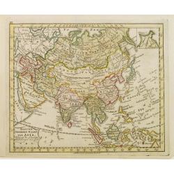
L'Asia secondo Le ultime osserviazioni divisa né suoi stati principali.
First edition on laid paper. Cassini’s splendid map depicts Asia at the end of the eighteenth century. There is good details of the region east of the Caspian Sea, show...
- $750 / ≈ €649
Date: Rome, 1788
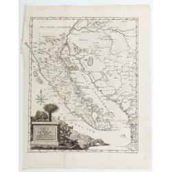
Carta Della California Suo Golfo E. Contracoste della Nueva Spagna.
Map featuring the California Peninsula and New Spain by Francisco Saverio Clavigero, engraved by J. Zambelly. Title cartouche within a landscape of cacti and palm trees.O...
Date: Venice, 1788
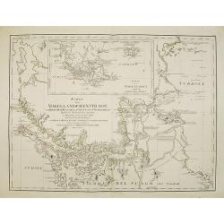
Karte der Magellanischen-Strasse. . .
Very detailed map of Strait of Magellan, with in top inset map of Southern tip of South America with the Falklands. Prepared by Don Juan de La Cruz of Spain.Engraved by J...
- $600 / ≈ €519
Date: Vienna, 1789
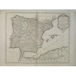
Carte de l'Espagne Dressée par Guillaume Delisle sur la description de Rodrigo Mendez Sylva . . .. Le tout augmenté et vérifié en 1789. Par Phil. Buache, de l'Académie des Sciences.
Map of Spain published at the outbreak of the French Revolution. Taken from the Atlas Géographique.. published by Dezauche, as successors to De l'Isle & Buache. Publ...
Date: Paris, 1789
Des Russischen Reiches Statthalterschaften Neurussland, Asow, und das Oestliche Nogay
Map showing Lake Asow and the Crimea. The river Dnepr until Krementschug, and the river Don until Pawlowsk. Published by Franz Johann Joseph von Reilly.
Date: Vienna, 1789
Geographische General Karte Der Gränzen zwischen denen dreyen Kaiserthümern und ihren nach und nach geschehenen Veränderungen vom Jahr 1718 bis heutigen Tags. . .
Detailed map of present-day Bulgaria, which is carved into the Ottoman provinces of Bulgaria, Macedonia, and Romania (Rumelia), the Crimea and the Black Sea. Prepared by ...
- $1250 / ≈ €1082
Date: Vienna, 1788-1789
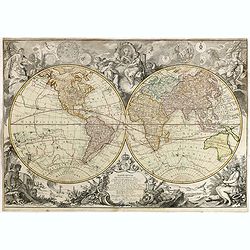
Mappemonde Dressée sur les Relations les Plus Nouvelles et les plus approuvées assujeties aux Obserations de Mrs. De L'Académie Royale des Sciences.
Dated 1761, this state is unknown. "Desnos' includes a fine combination of up to date cartographic information and the routes of important 18th century voyages of ex...
- $4500 / ≈ €3895
Date: Paris, 1789
Des Russischen Reiches Statthalterschaften Pleskow, Polozk, Mohilew, Twer, Moskau, Koluga, Wolodimer, Iaroslaw, Tula, Smo, Lensko und Nischgorod. Nro.64
Map of the European part of Russia, centered on Moscow. Published by Franz Johann Joseph von Reilly, 1766-1820, who was a Viennese art dealer who turned to map publishing...
- $150 / ≈ €130
Date: Vienna, 1789
Des Russischen Reiches Statthalterschaft Archangel Nro.66
Map of the North Western part of Russia. Published by Franz Johann Joseph von Reilly, 1766-1820, who was a Viennese art dealer who turned to map publishing in his early t...
- $150 / ≈ €130
Date: Vienna, 1789
Des Russischen Reiches Statthalterschaften Pleskow, Polozk, Mohilew, Twer, Moskau, Koluga, Wolodimer, Iaroslaw, Tula, Smo, Lensko und Nischgorod. Nro.64
Map of the European part of Russia, centered on Moscow. Published by Franz Johann Joseph von Reilly, 1766-1820, who was a Viennese art dealer who turned to map publishing...
- $150 / ≈ €130
Date: Vienna, 1789
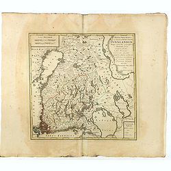
MAGNI PRINCIPATUS, ceu Provinciae REGNI SUECIAE, FINNLANDIAE Mappa generalis geographica : ex HASIANIS aliisque certissimis subsidiis, in suas Provincias minores sive speciales, tanquam statum politicum modernum . . .
A large and rarely seen map of Finland prepared by Haas. Extends from St. Petersburg north to well above the Gulf of Bothnia.
- $700 / ≈ €606
Date: Nuremberg, 1789
Die Asiatische Turkey begreift in sich Natolien, Georgien, Armenien, Mesopotamien Syrien, und Arabien. . .
Map of Turkey bordered by the Black Sea to the north, Syria and Sinai Peninsula to the south, Turkey in Europe to the west, with a small title cartouche. Explanatory text...
- $200 / ≈ €173
Date: Augsburg, 1789
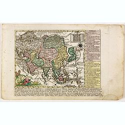
Asia verlegt von Ioh Mich Probst.
Uncommon map of Asia, with an explanatory text and directory on the right and the bottom of the map from the "Atlas Minor ex Tabulis Geographicis ".The map is o...
- $300 / ≈ €260
Date: Augsburg, 1789
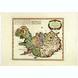
Die Insel Island Nro. 76.
An attractive map of Iceland based on the unpublished Knoff survey. The map locates villages and churches and graphically delineates the mountains, rivers, lakes and fore...
- $600 / ≈ €519
Date: Vienna, 1789
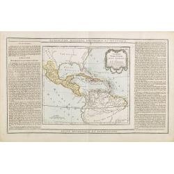
Guayane, Terre Ferme Isles Antilles. . .
Map showing Mexico, Cuba, Central America. Left and right a box with geographical information for each part country on the continent.Prepared by Louis Brion de la Tour an...
- $200 / ≈ €173
Date: Paris, 1790

Globe Terrestre. / Globe Celeste.
Showing a terrestrial and celestial spheres. Left and right a box with geographical information for spheres of different types.Prepared by Louis Brion de la Tour and publ...
- $400 / ≈ €346
Date: Paris 1790
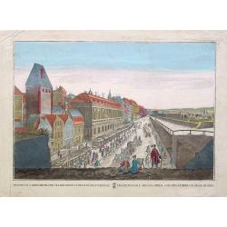
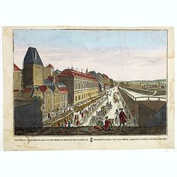
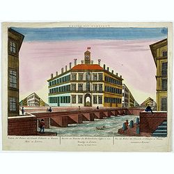
Prospectus primarii.. turrim rubram Viennae.
So-called optical print, showing Red tower in Vienna.In the eighteenth and nineteenth centuries there were many popular speciality establishments in Paris, Augsburg and L...
- $175 / ≈ €151
Date: Italy c.1790
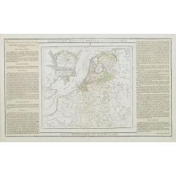
Les Pays Bas François, Autrichiens, et Hollandois..
Finely engraved map centered on the Netherlands, extending to include Belgium and Luxembourg.Finely embellished with a large title cartouche surmounted by Mercury's head....
Date: Paris, 1790
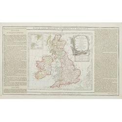
Les Isles Britanniques..
An attractive map of the British Isles including an inset of the Orkney and Shetland Islands. Finely embellished with a large title cartouche.The map is flanked by two co...
- $90 / ≈ €78
Date: Paris, 1790
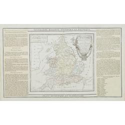
L'Angleterre divisée en 5 grandes Parties. . .
A very attractive map of England and Wales showing its 52 counties and the major cities as well as five large regional divisions.Finely embellished with a large title car...
- $100 / ≈ €87
Date: Paris, 1790
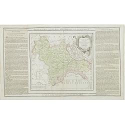
L'Etat de Venise et le Duché de Mantoue..
Attractive map covering the region centered on today region Veneto and its chief town Venice.Extending westwards to include part of Lombardy and eastward to Trieste and I...
- $100 / ≈ €87
Date: Paris, 1790
Partie de l' Italie, comprenant les Etats du Roy de Sardaigne. . .
Decorative map of northwest Italy and the Golfo di Genova. With ornamental title cartouche.Flanked by two columns of French text containing geographical information about...
- $100 / ≈ €87
Date: Paris, 1790
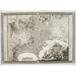
Planta della citta di Napoli come esifte nel prefeute Anno MDCCXC.
This stunning large-scale plan of Naples was prepared by Rizzi-Zannoni and engraved by Giuseppe Guerra from Naples. To the right and left a key to the important places of...
Date: Naples, 1790
![[North America]](/uploads/cache/25907-250x250.jpg)
[North America]
Uncommon map of North America. The young United States incorporates the upper Midwest, with the remaining western territories of Louisiana, Nouveau Mexique, Nouveau Albio...
Date: Augsburg, ca. 1790
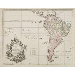
L'Amerique selon l'Etendue de Ses Principales Parties et don't les Points Principaux. . .
Uncommon map of South America, decorated with an elaborate cartouche referring to the conversion of the natives to Christianity, with natives bowing to a figure holding a...
Date: Augsburg, ca. 1790
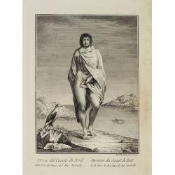
Uomo del Canale di Noël della terra del Fuoco, nel Mar Australe. / Homme du Canal de Noël de la terre de Feu dans la Mer Australe.
Full portrait of a man from Christmas Sound, in Tierra del Fuego This engraved print on laid paper is from "Raccolta di stampe," a series of historically sign...
Date: Venice, Antonio Zatta, c.1790
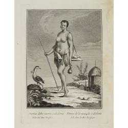
Donna della nuova Caledonia Isola del Mar Pacifico. / Femme de la nouvelle Calédonie Isle dans la Mer Pacifique.
Full portrait of a woman from New Caledonia. A rare engraving from "Raccolata di stampe ... di varie nazioni". From the original drawing by William Hodges, who ...
Date: Venice, Antonio Zatta, c.1790
![[Asia and part of Australia]](/uploads/cache/26453-250x250.jpg)
[Asia and part of Australia]
An engraved map of Asia shows an oversized Japan and part of Australia, called Neu Holland. To the east of the Caspian Sea, we see the area of present-day Uzbekistan and ...
- $450 / ≈ €389
Date: Tübingen, Heerbrandt, 1790
![[Title page] Atlas National et Général de la France en 20 Cartes..](/uploads/cache/24167-250x250.jpg)
[Title page] Atlas National et Général de la France en 20 Cartes..
Title page, from "Atlas National et Général de la France en 20 Cartes, divisée en ses 83 Départemens et 547 Districts, distingués par différentes couleurs de m...
- $80 / ≈ €69
Date: Paris, 1790
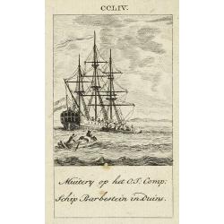
Muitery op het O:I: Comp. schip Barbestein in Duins.
Anonymous engraving of a mutiny of the VOC ship Barbestein .
Date: Amsterdam c.1790

Le Royaume de Boheme, le Duché de Silesie, et les Marquisats de Moravie et Lusace, dresses d'apres les cartes de Muller . .
Map of Poland, Bohemia, Silesia, Moravia and Lusatia. Large decorative title cartouche in upper right. In upper left corner inset plan of Breslau and in lower right a ins...
Date: Paris, 1790
L' Amerique dressée pour l'étude de la géographie . . .
Map showing the American continent. California with a large inlet. Some major cities, bodies of water, and geographic features are marked. There are illustrations of ship...
- $200 / ≈ €173
Date: Paris, 1790
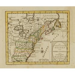
Die Vereinigten Staaten von Nord Amerika..
Uncommon map of the east coast of North America, including the Great Lakes area. To the right inset map of New Foundland. After the map by William Faden of 1783. With col...
- $500 / ≈ €433
Date: Germany, 1790
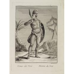
Uomo del Perù. / Homme du Perou.
Full portrait of a Peruvian warrior. From “Raccolta di … stampe.” a series of historically significant eighteenth-century copper plate engravings by Venetian engrav...
Date: Venice, Antonio Zatta, c.1790
Prospectus primarii telonii caesarei prope turrim rubram Viennae. . .
So-called optical print, showing Red tower in Vienna.In the eighteenth and nineteenth centuries there were many popular specialty establishments in Paris, Augsburg and Lo...
- $80 / ≈ €69
Date: Italy c.1790
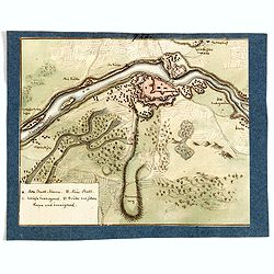
(Manuscript map of Narva und Ivangorod.)
An early manuscript very finely executed watercolor town-plan of the town of Narva, located at the eastern tip of Estonia, on the Russian border.With a key in lower left ...
- $1000 / ≈ €865
Date: Germany?, c. 1790
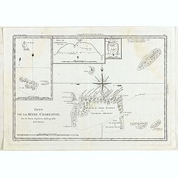
Isles de la Reine Charlotte.
Four charts on one page including chart of Nendö Island, largest of the Santa Cruz Islands, part of the Solomon Islands group, as mapped by Captain Cartaret in 1767, the...
- $40 / ≈ €35
Date: Paris, 1790
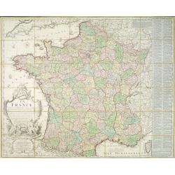
La France divisée en 83 départemens suivant les décréts de l'Assemblée Nationale, sanctionnés per le Roi. . .
An interesting folding map of France divided in 83 departments, to the right the 83 departments added on past-on slips. Another past-on is advertising Desnos' atlas in la...
Date: Paris, 1790
![[Title page] France divisée en 83 departements. [with title in manuscript].](/uploads/cache/39099-250x250.jpg)
[Title page] France divisée en 83 departements. [with title in manuscript].
Title page with in panel manuscript title in brown ink "France divisée en 83 departements. . .". On verso a manuscript compass rose. Title page engraved by P. ...
Date: Paris, ca. 1790
Prospect von Livorn. - Venduta del Palazo del Console D'Olanda in Venezia Nova in Livorne.
So called optical print published by Joseph Carmine showing the home of the Dutch consul in Livorno. Engraved after a design of Antonio Piemontesi. A well-known publisher...
- $100 / ≈ €87
Date: Augsburg, ca. 1790
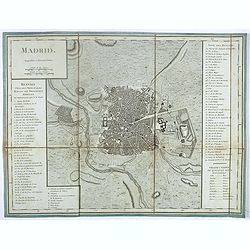
Madrid.
Plan of Madrid, by Tardieu. With numbered key (1-74) of the main buildings and buildings of the city. Table with translations of Spanish words in the right bottom.
- $150 / ≈ €130
Date: Paris?, ca. 1790
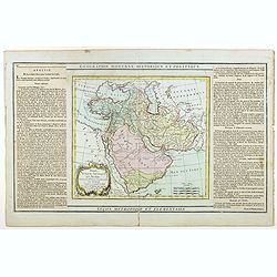
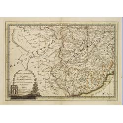
Perse, Turquie Asiatique et Arabie. . .
Attractive map covering the Arabian Peninsula, Turkey, Palestine, the Caucasus, today's Iraq and Iran.Flanked by two columns of French text containing geographical inform...
- $300 / ≈ €260
Date: Paris, 1790
![[Map of Madagascar, Mauricius island and Réunion island, in Cyrillic ].](/uploads/cache/42567-250x250.jpg)
[Map of Madagascar, Mauricius island and Réunion island, in Cyrillic ].
A map of the south eastern coast of Africa and the island of Madagascar, comprehending 2 insets of the island of Bourbon (today Reunion) and Mauritius.The title appears i...
- $750 / ≈ €649
Date: Paris / St.Petersburg, ca. 1790
![КАРТА ТАТАРИ КИТАЙСКОЙ [Map of Tartary in Cyrillic ].](/uploads/cache/44336-250x250.jpg)
КАРТА ТАТАРИ КИТАЙСКОЙ [Map of Tartary in Cyrillic ].
A rare map of Tartary, including Korea, China and Tibet.This Cyrillic version of the map appeared in one of the first world atlases published in Russia "Novy Atlas, ...
- $750 / ≈ €649
Date: Paris / St.Petersburg, ca. 1790
![[Lot of 6 maps / prints] Schets van de Donkere Baai in Nieuw Zeeland 1773.](/uploads/cache/20531-(1)-250x250.jpg)
[Lot of 6 maps / prints] Schets van de Donkere Baai in Nieuw Zeeland 1773.
A map of Dusky Bay, visited by James Cook in 1773. From a Dutch edition of ‘Cook's voyages'. Schets van de Donkere Baai in Nieuw Zeeland 1773. Nicolas Bellin's map of t...
- $350 / ≈ €303
Date: London, c, 1790
![[Title page] Atlas National et général de la France en 20 cartes. . .](/uploads/cache/47744-250x250.jpg)
[Title page] Atlas National et général de la France en 20 cartes. . .
Title page of Atlas National et général de la France en 20 cartes published by Louis Charles Desnos in 1790.
- $150 / ≈ €130
Date: Paris, 1790
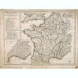
Gallia Antiquae. . .
A fine map of ancient France.
Date: London, 1790

Turquie Européenne, Avec les Pays limitrophes. . .
Copper engraved map centered on Greece, extending northwards and eastwards to include the Balkans and Ukraine as well as Cyprus.The map is flanked by two columns of Frenc...
- $50 / ≈ €43
Date: Paris, 1790
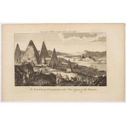
The Egyptian Pyramids with a View of part of the Nile &c.
This is a rather fanciful and possibly imagined copperplate view of the famous Egyptian Pyramids (which all come to very pointy tips!) and the covering part of the mighty...
Date: London, ca 1790
De vereenigde staten van Noord America.
Rare miniature map of Eastern United States. The map carries the signatures of W.Holtrop and the engraver H.Klokhoff. Steven van Esveldt's business was carried on by his ...
- $450 / ≈ €389
Date: Amsterdam, 1791
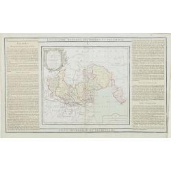
Des Hochstifts Luttich..
Uncommon map covering the area of Limburg in present day Belgium. Also including western borderline of the Dutch province of Limburg.
Date: Vienna, 1791
L'alta Lombardia, Terzo Foglio Che comprende parte degli Stati del Re di Sardegna e parte della Repubblica di Genova.
Interesting map covering the border between France and Italy. In Nuovo Atlante Geografico Universale.
- $200 / ≈ €173
Date: Rome, 1791
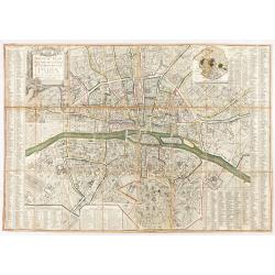
Nouveau plan routier de la ville et faubourgs de Paris. 1791
Plan quadrillé en segments, entoilé. De part et d'autre "Table alphabétique des rues". Plan mis à jour auquel on a ajouté dans un cartouche en bas : un pla...
Date: Paris, 1791
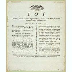
Loi relative à l'exercice de la pharmacie, et à la vente et distribution des drogues et médicamens. Donnée à Paris, le 17 avril 1791.
Decree of the National Assembly of April 17, 1791 concerning the practice of pharmacy. Published in Saintes (Fait à Saintes le 13 mai 1791) by P. Toussaint, printer of t...
- $150 / ≈ €130
Date: Saintes, P. Toussaint, 1791
Atlas general A L'Usage Des Colleges Et Maisons..
Rare atlas, published by Mondhare, maps dated 1780,1781 and 1793. Usually bright, attractive copy for a work of this kind. As announced in its title, this work was specif...
- $6000 / ≈ €5193
Date: Paris, 1791
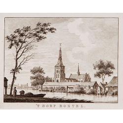
't dorp Boxtel.
Rare print of a view on the town of Boxtel (near Eindhoven), from Vaderlandsche gezichten of afbeeldingen.. by J.Bulthuis, printed by H.Gartman in Amsterdam.
- $150 / ≈ €130
Date: Amsterdam, 1786-1792

't dorp Aalst.
Rare print of the old church of Aalst (near Eindhoven), from Vaderlandsche gezichten of afbeeldingen.. by J.Bulthuis, printed by H.Gartman in Amsterdam.
Date: Amsterdam 1786-1792
Nieuwe Generale Kaart van Asia.
Uncommon map of Asia, with Dutch text. Engraved by A.Krevelt. In the upper right-hand corner, inset the map of Siberia. The region east of the Caspian Sea, showing modern...
- $120 / ≈ €104
Date: Amsterdam, 1792
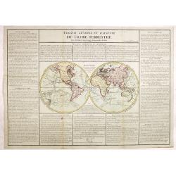
Tableau général et raisonné du Globe Terrestre. . .
Uncommon double hemisphere world map showing the tracks of Cook (1771-73, 1771 and Clarcke (1779). Surrounded by geographical information for each continent along with us...
- $1000 / ≈ €865
Date: Paris 1792
Charleroy place forte du Comte de Namur pres de la Riviere de Sambre. . .
A very decorative and extremely rare town-view of Charleroi. Engraved by Pierre-Alexandre Aveline. With "fait par Aveline avec privilege du Roy" in lower margin...
Date: Paris, ca.1792

Il Governo di Guascogna con porzione del Governo di Guienna.
Rare regional map of France of the Périgord, Guienne, Gascogne and the Béarn published by Carli Pazzini in Siena.
Date: Siena, 1792
Nouvelle Carte de la Petite Tartarie et la Mer Noire, montrant les Frontieres de l'Impératrice de Russie et de l'Empereur des Turcs, tant en Europe qu'en Asie, Dessigné selon la proposition de G. De L'Isle et d'autres Auteurs.
Shows Ukraine and the Black Sea in a fine impression with original 18th-c. hand-coloring. Elwe published an atlas in 1792, mainly using the copperplates of Joachim Ottens...
- $500 / ≈ €433
Date: Amsterdam, 1792
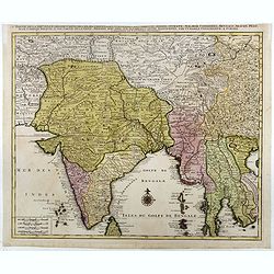
Partie de la nouvelle grande carte des Indes Orientales. . .
This is the northwest sheet of a four-sheet map of Southern and Southeast Asia, showing the Bay of Bengal and extending from the Pakistani border across India to the Indo...
Date: Amsterdam, 1792
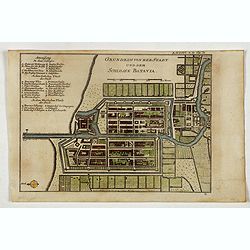
Grundriss von der Stadt und dem Schlosse Batavia.
Uncommon plan of the town and fortress of Batavia. The plan is based on the earlier, much larger map of Batavia published by Clement de Jonghe in 1650. From 'Algemeine We...
- $175 / ≈ €151
Date: Halle, 1763-1792
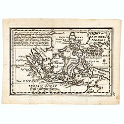
East India Islands
Good detail on Philippines. Uncommon miniature map from Gibson's "Atlas Minimus, or a New Set of Pocket Maps of the several Empires, Kingdoms and States of the known...
- $150 / ≈ €130
Date: London, 1792