Browse Listings in Europe
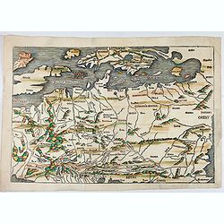
No title: Scandinavia/ Central Europe/ British Isles.
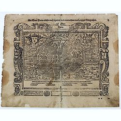
Map of Northern Europe from Nuremberg Chronicle . German text on verso. Printed by Anton Koberger. The map has been identified as the work of Hieronimus Münzer (1437-150...
Date: Nuremberg, 12 July 1493
![[Text page with imaginary towns in Westphalia and Hesse. CCLXXXIIII ].](/uploads/cache/37487-250x250.jpg)
[Text page with imaginary towns in Westphalia and Hesse. CCLXXXIIII ].
On recto, an imaginary view of towns in Westphalia (230x225mm.). Verso of towns in the province Hesse.Page from the richest illustrated Incunabula, the famous: Nuremberg ...
- $200 / ≈ €175
Date: Nuremberg, 12 July 1493
![Parisius & Maguncia. [Paris & Munich] Folio XXXIX](/uploads/cache/29718-250x250.jpg)
Parisius & Maguncia. [Paris & Munich] Folio XXXIX
Imaginary view of Paris and on verso Munich : however the earliest obtainable views of this period.In the forground a large vessel, who was the symbol of the powerful cor...
Date: Nuremberg, 12 July 1493
PATAVIA (Passau, Germ)
From the first Latin text edition, 1493. The view of PATAVIA (nowadays the city of Passau, Southern Germany) was part of the Liber Chronicarum cum figuris et ymagibus ...
Date: Nuremberg, Germany, 1493
![Terta Etas Mundi. Foliu CX [With view of Metz]](/uploads/cache/46260-250x250.jpg)
Terta Etas Mundi. Foliu CX [With view of Metz]
The Latin text page is illustrated with a depictions of Kings, Noble men and women and scientists, among Eustace (Eustachius) a Roman soldier and martyr, appears as a bea...
- $450 / ≈ €393
Date: Nuremberg, 12 July 1493
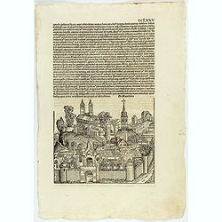
CCLXXV.
The Latin text page is illustrated with an imaginary view of a town in Macedonia (195 x 225mm.) The Nuremberg Chronicle, published the year that Columbus returned to Euro...
Date: Nuremberg, 12 July 1493
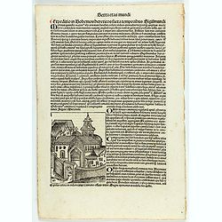
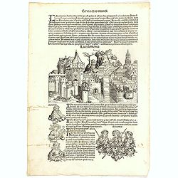
Sexta etas mudi CCXXXIX.
The Latin text page is describing the crusade against the Bohemian heretics in the time of emperor Sigismund Nuremberg Chronicle, published the year that Columbus returne...
Date: Nuremberg, 12 July 1493
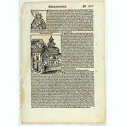
Sexta etas muidi Fo CCV.
The Latin text page is illustrating Baldwin (Baldvinus), the fourth of this name, seventh king of Jerusalem, and son of the aforesaid Amalric, reigned six years after his...
- $75 / ≈ €66
Date: Nuremberg, 12 July 1493
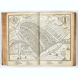
![Sexta Etas Mundi. Bressla. [Breslau or Wrocław] CCXXXIIII.](/uploads/cache/33138-250x250.jpg)
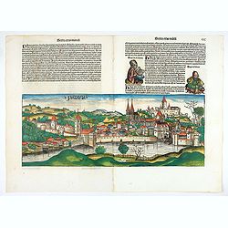
Sexta Etas Mundi. Bressla. [Breslau or Wrocław] CCXXXIIII.
A very fine presentation of the city of Bresslau / Wrocław (230 x 520mm.), in Poland, centered on the cathedral (Dim. : 232 mm W : 520 mm).Overleaf, the kings Wenceslaw ...
Date: Nuremberg, 12 July 1493
Tercia Etas Mundi. Foliu. XXVIII (with a view of the city of Lacedaemon or Sparta)
The Latin text page is illustrated with depictions of Kings, Noble men and women and scientists, including Atlas. RECTO : In the first panel, at the left, are some of the...
- $150 / ≈ €131
Date: Nuremberg, 12 July 1493
Secunda Asiae Tabula (Ukraine and Russia)
Woodblock printed a large-format Ptolemaic map showing Russia, Ukraine, and the Black Sea region. From the 1513 edition of Waldseemüller's Geographia.One of the earliest...
Date: Strasburg, 1513
![Tabula III Asiae. [Caucasus and Armenia.]](/uploads/cache/47571-250x250.jpg)
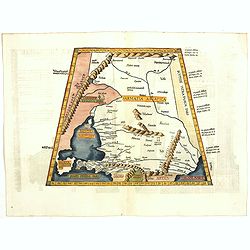
Tabula III Asiae. [Caucasus and Armenia.]
Ptolemaic map of the region south of the Caucasus Mountains and between the Caspian Sea as far south as the headwaters of the Tigris River in the south and the Black Sea,...
- $750 / ≈ €655
Date: Lyons, M. Servetus, 1525
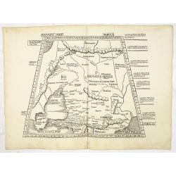
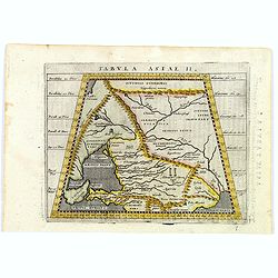
Tabula II Asiae.
A striking example of this wood-cut map depicts north of the Black Sea and west of the Caspian Sea (Ukraine, Russia, Georgia and Armenia). Ptolemy collected his data arou...
- $550 / ≈ €480
Date: Lyons, 1535
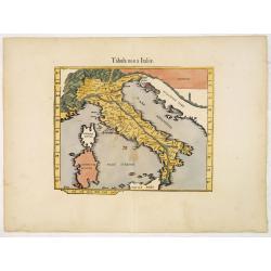
.Tabula nova Italiae. (Modern Italy)
Wood block printed modern map of Italy, prepared by Lorenz Fries and one of the earliest modern maps of Italy and environs. Based on the slightly larger map from 1513 pub...
Date: Vienna, 1525 -1541
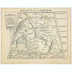
Tabula Asiae II (Black Sea and Caspian Sea)
The first edition of Munster's map of Ukraine and the region north of the Black Sea, based upon Claudius Ptolemy which appeared in his "Geographia Universalis",...
- $500 / ≈ €437
Date: Basel, Heinrich Petri, 1545
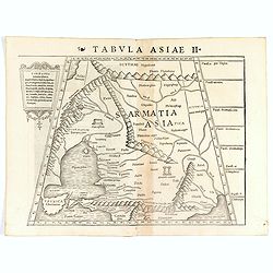
Tabula Asiae II (Black Sea and Caspian Sea).
The first edition of Münster's map of Ukraine and the region north of the Black Sea, based upon Claudius Ptolemy which appeared in his "Geographia Universalis"...
- $400 / ≈ €349
Date: Basel, Heinrich Petri, 1545
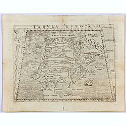
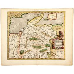
Tabula Europae II. (Spain and Portugal)
Gastaldi's map showing Spain and Portugal, based upon Ptolemy.It is one of the earliest obtainable maps of the region.From Giacomo Gastaldi's Atlas of 1548 which has been...
- $375 / ≈ €328
Date: Venice, 1548
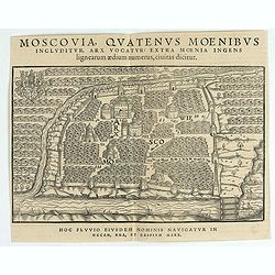
Moscovia Sigismundi Liberi Baronis In Herberstein, Neiperg et Gutehnag Anno M.D XLIX
The forst modern plan of Moscow. A rare and important cornerstone map for Russia collections.Sigismund von Herberstein made two visits to Russia. In 1517-18 he travelled ...
Date: Vienna, 1549
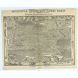
Moscovia Sigismundi Liberi Baronis In Herberstein, Neiperg et Gutehnag Anno M.D XLIX
First Modern Map of Russia. A rare and important cornerstone map for Russia collections.Sigismund von Herberstein made two visits to Russia. In 1517-18 he travelled as a ...
Date: Vienna, 1549
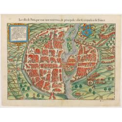
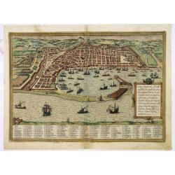
La ville de Paris, par tout tant renommée & principalle ville du royaulme de France.
Very early birds-eye view of Paris. From his Cosmographia, that great compendium of Renaissance knowledge. An exciting print.Engraved by Hans Rudolf Manuel-Deutsch(1525-1...
Date: Bâle, H. Petri, 1552
![[Lot of 2 leaves] Rubeaquum cum arce Isenburgo…/ Wyssenburg…](/uploads/cache/48269-250x250.jpg)
[Lot of 2 leaves] Rubeaquum cum arce Isenburgo…/ Wyssenburg…
Two wood block printed early bird's-eye views of Rouffach (lies along the Alsatian wine route) and Wissembourg (Alsace). From the 1552 Latin text edition of Münster's Co...
Date: Basel, 1552
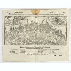
Colonia Agrippina civitas…
A wood block printed early panoramic view of Cologne (Germany). A lettered key A-Z beneath the view. The 1552 Latin text edition of Münster's Cosmographia is a short and...
- $70 / ≈ €61
Date: Basel, 1552
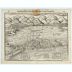
Lindoiae civitas insularis, undique aqua lacunari circunsusa.…
A wood block printed early bird's-eye view of Lindau on Lake Constance (Germany). A lettered key A-O in the plate. From the 1552 Latin text edition of Münster's Cosmogra...
Date: Basel, 1552
-250x250.JPG)
Fiandra Brabantia et Holanda nvova
Fiandra Brabantia et Holanda nvovaDella Fiandra Brabantia, et Olanda quinta nvova tavola d’EuropaThis map is the first known map of the Netherlands as a whole. It comes...
Date: Venetië, 1561
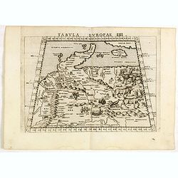
Tabula Europae IIII.
The scarce FIRST edition of this classical map depicting Northern Europe, Denmark and the Baltic. Includes engravings of a number of interesting animals in the right-hand...
- $450 / ≈ €393
Date: Venice, 1561
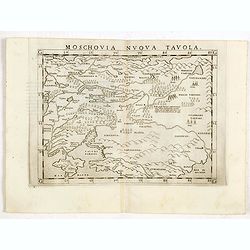
Moschovia nuova tavola.
Scarce FIRST edition of this map centered on Moscow. In the lower left Crimea and the Sea of Azov. The map is filled with small tents to represent Tartar camps.Girolamo R...
- $300 / ≈ €262
Date: Venice, 1561
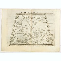
Tabula Asiae II.
Scarce FIRST edition of this map of the ancient region of Asiatic Sarmatia - now Southern Russia and part of Ukraine, around the Azov seaGirolamo Ruscelli's edition of Pt...
- $300 / ≈ €262
Date: Venice, 1561
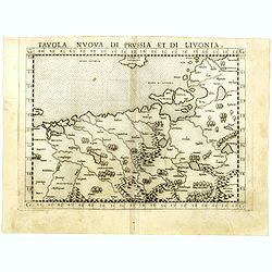
Tavola nuova di Prussia et di Livonia.
Uncommon first edition of this early map of the region from Pomerania to Livonia, includes a portion of Estonia, and coastal detail on the Baltic Sea with a small section...
- $400 / ≈ €349
Date: Venice, Vincenzo Valgrisi, 1561
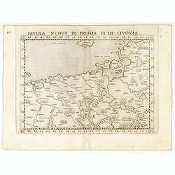
Tavola nuova di Prussia et di Livonia.
Uncommon first edition of this early map of the region from Pomerania to Livonia, includes a portion of Estonia, and coastal detail on the Baltic Sea with a small section...
Date: Venice, Vincenzo Valgrisi, 1561
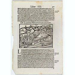
De Lucerna Helvetiorum Civitate. (Luzern)
One Latin text page with a wood cut bird's-eye view of Luzern (147x157mm). From Münster's Cosmographia Universalis. The Cosmographia by Sebastian Münster from 1544 is t...
- $50 / ≈ €44
Date: Basle, ca. 1564
![Groeninga MDLXXIII. [Groningen]](/uploads/cache/27192-250x250.jpg)
Groeninga MDLXXIII. [Groningen]
RECTO: A panoramic view of the city of Groningen dated 1573.VERSO: a woodcut of a cow, a bull and their calf.Taken from Sebastian Munster's encyclopedic work, the "C...
Date: Basle, ca. 1564
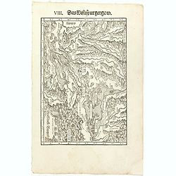
VIII. Das Wiflispurgergow.
Very early wood cut printed regional map of Switzerland with Lake Geneva.Originally engraved in 1548. The map was prepared by Johannes Stumpf (1500-1576). Included in &qu...
Date: Zurich, Christoffel Froschover, 1548,1552-1566
-250x250.jpg)
La descrittione di Belgica con le sve frontiere (maps of the Seventeen Provinces)
La descrittione di Belgica con le sve frontiere Omnis Belgica intra Rhenum, marronam, Sequana[m] ac Oceanum, ... This is one of the earliest printed maps of the Sev...
Date: Antwerp, 1567
DESCRIPTION DE TOUT LE PAIS BAS Autrement dict La Germanie Inferieure, ou Basse-Allemaigne…
First French edition. Illustrated with a coat of arms and portrait of Philips II, with a folding map of The Netherlands and maps and views of Brabant, Louvain, Brussel, A...
- $4500 / ≈ €3931
Date: Anvers. Guillaume Silvius, 1567
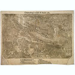
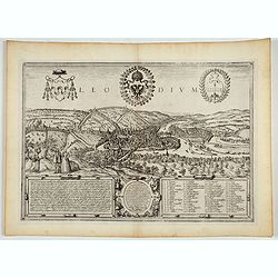
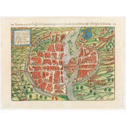
Orleans assiegé au mois de Janvier. 1563.
Rare copper engraved view of the siege of Orleans in January 1563, engraved by Jean Jacques Perrissin, (1536 - before 1611).Print from the suite "The Wars, Massacres...
- $100 / ≈ €87
Date: Geneva, ca. 1570
![[Euboe].](/uploads/cache/41989-250x250.jpg)
[Euboe].
Woodcut Ptolemaic-style map by Sebastian Münster figuring Euboea Island, published in the edition of Strabo by Henri Petri in 1571."Strabonis rerum geographicarum&q...
Date: Basle, Henri Petri, 1571
Basiliensis territorii descriptio nova.
Left hand map centered on Basle, east to top. With credit to Sebastian Münster in title cartouche.
- $200 / ≈ €175
Date: Antwerp, 1573
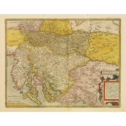
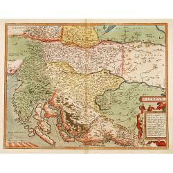
Illyricum.
Early map of Istria and Slovenia. Prepared by Johann Sambucus 1572.The map is in a strictly contemporary coloring.Read more about coloring.
- $400 / ≈ €349
Date: Antwerp, 1574
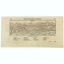
Die statt Montpellier . . .
Panoramic view of Montpellier by Sebastian Münster. Below the engraving a letterpress key. From the German edition of Sebastian Munster's Cosmography, "Cosmographey...
Date: Basel, Heinrich Petri, 1574
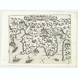
Provincia Di Albania.
Uncommon map of Albania, from Giovanni Francesco Camocio's rare " Isole Famose porti, fortezze, e terre maritime . . ." The second state, includes the plate n...
- $1200 / ≈ €1048
Date: Venice, D.Bertelli, ca.1574
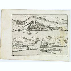
Trau citta nella Dalmacia vicino al Spaleto. . .
Uncommon map of the Dalmatian coast with the town of Trau (Trogir) in Croatia, from Giovanni Francesco Camocio's rare " Isole Famose porti, fortezze, e terre maritim...
- $1000 / ≈ €874
Date: Venice, D.Bertelli, ca.1574
Sebenico antiquam.e Sico detto Citta nobile nella prouincia della Dalmacia. . .
Uncommon map of the coast of Croatia with the bay and town of Šibenik (Sebenico) with Venetian war ships in the foreground. From Giovanni Francesco Camocio's rare "...
- $1000 / ≈ €874
Date: Venice, D.Bertelli, ca.1574
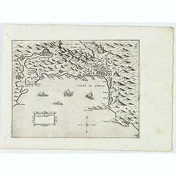
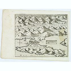
Golfo de Lodrin con parte di Albania.
Rare map of the northern coast of Albania, Serbia and Montenegro, extending from Malonta and Castel Novo and Bocca del Colfo di Cattaro to Durrës. Venetian war ships in ...
- $1500 / ≈ €1310
Date: Venice, D.Bertelli, ca.1574
Illyricum.
Early map of Istria and Slovenia. Prepared by Johann Sambucus 1572.
Date: Antwerp, 1574
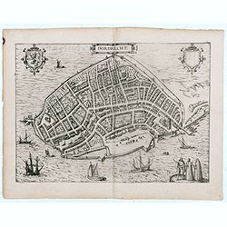
Dordrecht.
Very desirable and early town-plan of Dordrecht.From volume one of the greatest publication in this genre!. The Civitates was compiled and written by George Braun, Canon ...
- $200 / ≈ €175
Date: Cologne, 1575
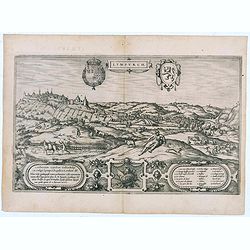
Lympurch. (Limburg)
Very desirable and early town-plan of the city of Limburg in Belgium with its fortifications at the end of the 16th century.From volume one of the greatest publication in...
- $250 / ≈ €218
Date: Cologne, 1575
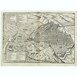
Le vray portraict de la Ville de Marseille.
Fine wood cut bird's-eye view of Marseille. Decorated with several ship in the harbour and on the sea. To the left two keys describing the main buildings and places. Publ...
Date: Paris, 1575
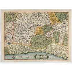
Pedemontanae Vicinorumque Regionum.
Fine map including the Italian coast from Monaco till Genoa. Milan in the upper righthand corner and Turin in the center of the map.
- $600 / ≈ €524
Date: Antwerp, 1574-1575
Leodium. (Luik or Liège)
Very desirable and early town-view of Liège, which shows the city with the Meuse flowing in its favorable location amongst gentle hills, sturdy trees and fertile fields....
- $300 / ≈ €262
Date: Cologne, (1572) 1577
Messana, Urbs est Sicilie maxima, situ, opulentia, & tuta navium statione.
Very desirable and early town-plan of Messina on Sicily, with a numbered key (1-167) in lower part. "Messina is shown from the east, in a view looking down upon the ...
Date: Cologne, (1572) 1577
![Sevilla, Hispalis ... [on sheet with] Cadiz [and] Malaga.](/uploads/cache/33642-250x250.jpg)
Sevilla, Hispalis ... [on sheet with] Cadiz [and] Malaga.
Very desirable and early view of Sevilla, Cadiz and Malaga, with the Roman and Moorish citadels on the hills in the background. "In the upper part Sevilla, showing ...
- $500 / ≈ €437
Date: Cologne, (1572) 1577
Die Statt Paris etlicher mass figuriert und contrafehtet nach jetziger Gelegenheit.
Published in the "Universal Cosmography" of S. Münster. Text in German. Under the legendary plan in German A to G. It is framed by a border composed of foliage...
- $200 / ≈ €175
Date: Bâle, H. Petri, 1578
Exacta novaqve descriptio dvcatvs Andegravensis qvem vvlgari nomine Le Duche d'Aniou Indigitant.
Centered on the town of Angiers. From the first edition of De Jode's Speculum Orbis Terrarum, the second general atlas of the world, after Ortelius. Engraved by Ioannes V...
- $750 / ≈ €655
Date: Antwerp, 1578
![[Paris] Die Statt Paris etlicher maß figuriert und contrafehret nach jetziger Gelegenheit.](/uploads/cache/49189-250x250.jpg)
[Paris] Die Statt Paris etlicher maß figuriert und contrafehret nach jetziger Gelegenheit.
Bird's-eye view of Paris. From a German text edition of S. Münster's Cosmographia, which is a short and complete summary of Renaissance knowledge. Text in German. Under ...
Date: Basle, 1550-1580
Lutezia citta de Parigini celebratissima per tuto. . .
Very early birds-eye view of Paris. From his an Italian edition of his Cosmographia, that great compendium of Renaissance knowledge. An exciting print.Engraved by Hans Ru...
Date: Basle, 1550-1580
1) Caletensivm et Bononiensivm..2) Veromandvorvm eorvmque..
Prepared by Jean Surhon, cartographer, goldsmith and engraver. From 'Theatrum Orbis Terrarum [Atlas of the Whole World]': published in Antwerp.
- $200 / ≈ €175
Date: Antwerp, 1580
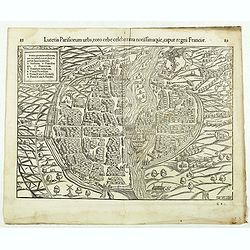
Lutetia Parisiorum urbs, toto orbe celeberrima notissimaque, caput regni Franciae.
Early bird's eye view of Paris, called at the time Lutetia. From a French text edition of S. Münster's Cosmographia, which is a short and complete summary of Renaissance...
Date: Basle, 1550-1580
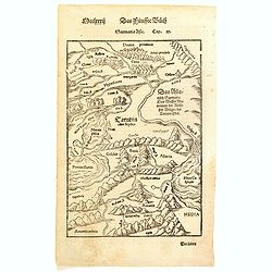
Sarmatia Asie.
The map is showing the area of Armenia and Kazakhstan. From his Cosmographia, that great compendium of Renaissance knowledge. Sebastian Münster was born in Nierder-Ingel...
- $90 / ≈ €79
Date: Basle, 1550-1580
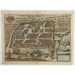
Moscavw. Moscovia, Urbs regionis eiusde nominis metropolitica, duplo maior. . .
Showing Moscow within the walled city and figures in the foreground. Title cartouche in the lower right corner Moscovia, Urbs. Regionis ciusde nominis metropolitica, dup...
Date: Cologne, 1580
The Best Ptolemaic Map of Germany: Europ. IIII. Tab.
An elegantly engraved map of Germany as it was known in the Roman Imperial Period from Mercator’s definitive edition of Ptolemy’s geography. It was based on geographi...
Date: Lyons, 1584
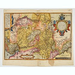
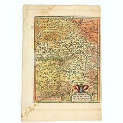
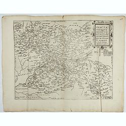
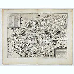
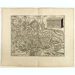
Westphaliae Totius, Finitimarumque Regionum Accurata Descriptio.
A very beautiful hand colored copper engraved map of North Rhein-Westphalia by A. Ortelius. This is a general map of Westphalia and the surrounding regions in northwest G...
Date: Antwerp, ca 1584
Veronae Urbis Territorium.
Very fine map of part of Italy centered on Verona, Vizenza and Lake Garda. Prepared by Bernardino Brugnoli, which first was published in 1574 by Forlani. Ortelius' map is...
Date: Antwerp, 1584

Beschrijvinge vande de zee Cuften va Vlanderen en Picardien. . .
A detailed description of the coast of Picardie and Normandy decorated by a large colored baroque title cartouche, and the coat of arms of Flanders with a colorful scale ...
- $1750 / ≈ €1529
Date: Amsterdam, 1585
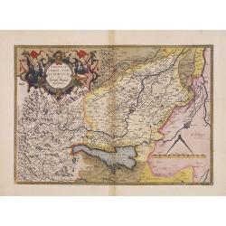
ARTESIA Comit.
Mercator's early map of the northern French region of Artois. Divisions in outline colors, strap-work title cartouche and mileage scale in the upper right, and lower left...
Date: Duisbourg, 1585
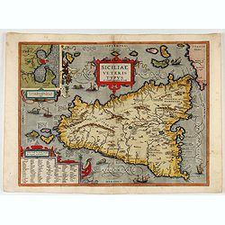
Siciliae Veteris Typus.
A very beautiful early map of ancient Sicily. Title cartouche centered on the upper part: includes also an inset map of Syracuse in the upper left, and a list of the town...
- $600 / ≈ €524
Date: Antwerp, 1587
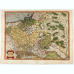
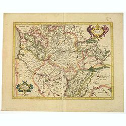
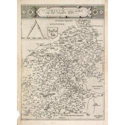
POLONIAE finitimarumque locorum descrip:tio. Auctore WENCESLAO GRODECCIO. Polono.
Ortelius' map of Poland, being a close copy of Grodecki / Pograbka's map of 1558/62 map, itself based on Wapovsky 1526 (Karrow 56) With Latin text on verso, a state 1 and...
- $1200 / ≈ €1048
Date: Antwerp, 1587
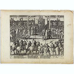
Wie ist das gluck so gar ungleich . . . Plate 18.
Early print showing a hanging in Brabant on 11 February 1620.Plate from the series about the " Eighty Years' War" or the independence war of Holland against Spa...
- $80 / ≈ €70
Date: Cologne, ca. 1590
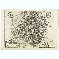
Valencena . . .
Eye-bird view of Valenciennes.
Date: Anvers, 1590
![[Prince of Condé captured and murdered, 1569]](/uploads/cache/38547-250x250.jpg)
[Prince of Condé captured and murdered, 1569]
Early print showing the Prince of Condé captured and murdered, 1569.Plate from the series about the " Eighty Years War" or the independence war of Holland agai...
- $50 / ≈ €44
Date: Cologne, ca. 1590
Picardiae Belgicae regionis descriptio
From Theatrum Orbis Terrarum [Atlas of the Whole World]. Prepared by Jean Surhon.Dare to go in Black. All early maps were printed in black and white, and many were kept t...
Date: Antwerp, 1590
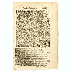
Von dem Moscowycern
Map centered on Moscow, with on verso a wood cut engraving of a Bison. From a German text edition of his Geographia , that great compendium of Renaissance knowledge.
- $125 / ≈ €109
Date: Basle, 1550-1590
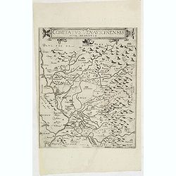
Comitatus Venayscinensis Nova Discriptio.
Rare map depicting part of Provence with Avignon, Cavaillon, Orange, Carpentras, etc.Gerard De Jode was the great rival of Ortelius, both made a living out of selling map...
- $325 / ≈ €284
Date: Antwerp, 1593
Nova et integra caenomaniae descriptio vulg. Le Mans.
1580-1593 DE JODE, G.. - Gerard De Jode's map of Caenomaniae (Maine Province), published before inclusion in his Speculum Orbis Terrarum
Date: Antwerp, ca. 1580-1593

Prussiae Regionis Sarmatiae Europae Nobilissimae Novaet vera descriptio . . .
Nice example of the first edition of De Jode's map of Prussia, from the 1593 edition of De Jode's atlas.The present map is an entirely new addition to the second De Jode ...
- $2200 / ≈ €1922
Date: Antwerp, 1593
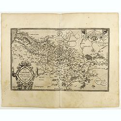
Bitvrigvm, provinciae que Berry.
A rare and beautifully engraved map from the second edition of De Jode's atlas "Speculum Orbis Terrarum". Includes the Loire Valley, centered on Bourges and Vie...
Date: Antwerp, 1593
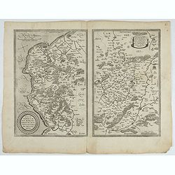
![Blaisois Blesiensis Territorii. . . [together with] - Lemovicum totius et confinium provinciarum. . .](/uploads/cache/28865-250x250.jpg)
Blaisois Blesiensis Territorii. . . [together with] - Lemovicum totius et confinium provinciarum. . .
The map on the left is centered on the Loire with the town of Blois. The right hand map is centered on Limoges.
- $150 / ≈ €131
Date: Antwerp, c. 1595
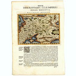
Descrittione Dell'Imperio della MOSCOVIA IMPERIUM.
Uncommon map including Latvia, Livonia, Lithuania, the Ukraine, and northern Part of the Black Sea and the Caspian Sea, Siberia, Georgia, Azerbaijan, Kazakhstan.Giovanni ...
Date: Venice, 1596
Tabula Asiae II.
A striking example of Magini's map of the Black Sea region from the 1597 edition of Magini's 'Geographia', based upon the work of Claudius Ptolemy. Latin text and tables ...
- $300 / ≈ €262
Date: Venice, 1597

Romaniae, (quae olim Thracia dicta) ..
Very fine map centered on the Danube area. The map is based on the double sheet map by Jacob Gastaldi. Abraham Ortelius (1527-1598) was a cartographer and publisher, who ...
Date: Antwerp, 1598
Helvetiae Descriptio . . .
A fine map based upon a map by the Swiss cartographer Aegidicus Tschudi of 1538.Dare to go in Black. All early maps are printed in black and white and many were kept that...
Date: Antwerp, 1598
