Browse Listings in East Meets West
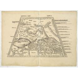
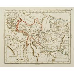
Septima Asie Tabula (Central Asia.)
A woodblock-printed large-format Ptolemaic map showing the region east of the Caspian Sea is labeled SOGDIANA. Sogdia or Sogdiana was an ancient Iranian civilization betw...
Date: Strasburg, 1513
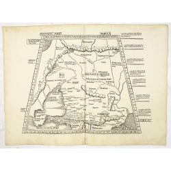
Secunda Asiae Tabula (Ukraine and Russia)
Woodblock printed a large-format Ptolemaic map showing Russia, Ukraine, and the Black Sea region. From the 1513 edition of Waldseemüller's Geographia.One of the earliest...
Date: Strasburg, 1513
![Septima Asie Tabvla. |Walsseemüller's map of Central Asia and the Silk Road]](/uploads/cache/62137-250x250.jpg)
Septima Asie Tabvla. |Walsseemüller's map of Central Asia and the Silk Road]
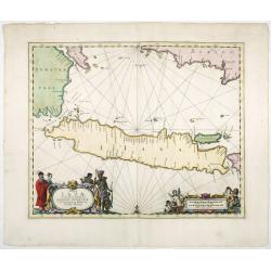
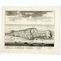
Trapezoidal woodcut map showing the area east of the Sarygamysh Lake, about midway between the Caspian Sea and the (former) Aral Sea. It is one of the earliest obtainabl...
Date: Strasburg, J. Schott, 1513
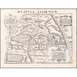
Tabula Asiae VII.
Attractive woodblock map, depicting the Caspian Sea, Black Sea and the Persian Gulf, extending to the Imaus Mountains. according to Ptolemy. In the center of the map is...
Date: Basle, 1542
Goa fortissima Indiae urbs in Christianorum potestatem anno Salutis 1509. devenit.
A rare and early woodcut view of Goa in India. Decorated with one ship. This woodcut was published in La Cosmographie Universelle de tout le monde, printed in 1575 in two...
Date: Paris, 1575
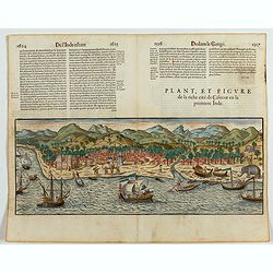
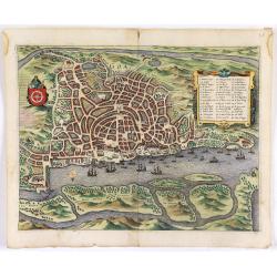
Plan, et figure de la riche cité de Calecut en la premiere Inde.
A rare and early woodcut view of Calcutta in India. Decorated with several ships on the sea, shipbuilding, fishermen and elephants.This woodcut was published in La Cosmog...
Date: Paris, 1575
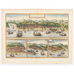
Calechut / Ormus / Canonor.
Four panoramic on one sheet: the upper approximately two-thirds of this double page sheet contains a fine panoramic view of Calicut which is on the west coast of India i...
Date: Cologne, 1580
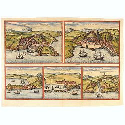
Tingis, Lusitanis, Tangiara. / Tzaffin. / Septa. / Arzilla/ Sala.
Views of the five northern and western African coastal town-view on one sheet: Latin text.From the greatest publication in this genre!. The Civitates was compiled and wri...
- $600 / ≈ €524
Date: Cologne, 1580

Chinae, olim Sinarum Regionis, nova descriptio. Auctore Ludovico Georgio.
The first map of China ever to appear in a Western atlas, west to the top. The first state without "las Philiooinas" somewhere in 1587 added to the plate. When ...
Date: Antwerp, 1584
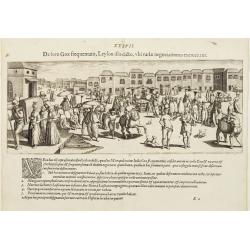
De foro Goae frequentato..
An attractive panorama view of the market square at Goa, with Indians and Portuguese traders, buying and selling various merchandise, with a row of colonial buildings in ...
Date: Frankfurt, 1607
![[Dutch ship Amsterdam].](/uploads/cache/37948-250x250.jpg)
[Dutch ship Amsterdam].
Text engraving of the Dutch vessel Amsterdam offshore the island of Java near Surabaya from "Premier livre de l'histoire de la navigation aux Indes Orientales, par l...
Date: Amsterdam, Cornille Nicolas, 1609

II Pars Indiae Orientalis in qua Johan. Hugonis Linschotani. . .
De Bry's Part II of his "Les Petit Voyages", containing "Pars Indiae Orientalis, in qua Johan. Hugonis Linscotani navagatio in Orientem, 1609", being ...
Date: Frankfurt, Wolffgang Richter, 1609
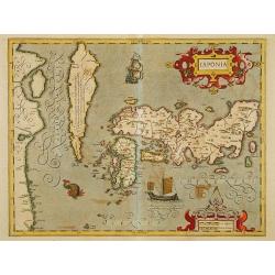
Japonia.
Jodocus Hondius' fine map early 17th-century map of the islands of Japan, was first issued as one of the new maps in the expended Mercator Hondius Atlas of 1606.The map i...
Date: Amsterdam, 1606-1620
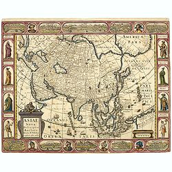
Asiae Nova Descriptio.
Final State of Pieter Van Den Keere's Rare Map of Asia -- The first map of Asia to include decorative panels. Published by N.J.Visscher and engraved by Abraham Goos, embe...
Date: Amsterdam, 1636
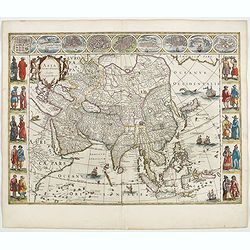
Asia noviter delineata. . .
From 1633 the members of the Blaeu family were official cartographers to the United East India Company and, as such, had access to the most up-to-date cartographic inform...
Date: Amsterdam, 1644
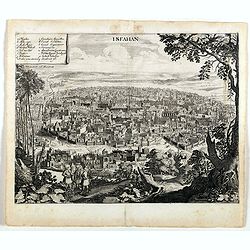
Isfahan.
An early of Isfahan in central Iran,. From the rare first edition "Offt begehrte Beschreibung der newen orientalischen Rejse, so durch Gelegenheit einer Holsteinisc...
- $250 / ≈ €218
Date: Schleßwig, Zur Glocken, 1647
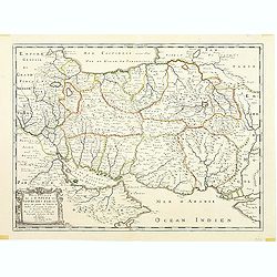
Description de l'Empire du Sophi des Perses tiree en partie de l'Arabe de Nubie, et en partie de plusieurs et diverses Relations.
The map of the Empire of Persia is shown to extend from Baghdad almost to the present-day borders of India. Including part of Saudi Arabia and Oman. Including "Golfe...
Date: Paris, 1650
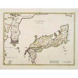
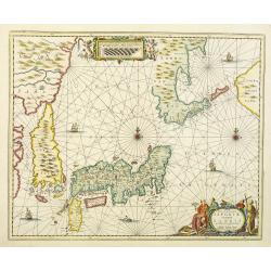
Japonia Regnum.
It is the first map to correctly show Korea as a peninsula.This was to remain the standard form of Japan until the eighteenth century and although replaced by the maps of...
Date: Amsterdam, 1655
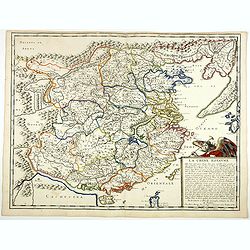
La Chine Royaume. . .
An important and attractive French map of the whole of China, the northern tip of the Philippines, with a strangely curved Korea and an under-sized Taiwan here called &qu...
- $2600 / ≈ €2271
Date: Paris, 1656
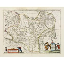
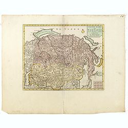
Tartaria sive Magni Chami imperium.
This is a detailed and decorative map of the Tartary and northern part of China, including the Chinese Great Wall, the Caspian Sea, and the Volga River east as far as the...
- $700 / ≈ €611
Date: Amsterdam, 1658
Insulae Iavae Cum parte Insularum Borneo Sumatrae, et Circumjacentium Insularum Novissima Delineatio.
This elegant chart focuses on the island of Java with parts of Sumatra, Borneo and Bali. The lack of interior detail correctly reflects the state of knowledge of the peri...
Date: Amsterdam, 1660
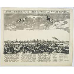
Constantinopolitanae urbis effigies ad vivum expressa.
A rare panoramic town-view of Istanbul with over the whole length of the lower part 3 columns of poems in Latin, Dutch and French and a numbered key 1-29 to the principal...
Date: Amsterdam, 1660
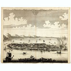
The citie and Castle Zelandia in the Island of Taywan. / Stadt en casteel Zelandia op 't Eilant Taywan.
This important copperplate engraving is one of the earliest European views of Taiwan, depicting the Dutch fortifications and trading settlements on the island's West coas...
Date: Amsterdam, 1675
Goa.
A finely engraved, detailed town-plan of Goa, the main Portuguese trading post in India. It also appeared in Gottfried’s Archontologia (1649). There is a cartouche iden...
Date: Frankfurt, 1680

Kam Hi Fils de Chien chi Empereur des Tartares orientaux?.plusieurs titres d'honneur Ecrits de sa propre main.
Very rare and decorative costume plate. Underneath the plate a descriptive text in French. Bears the address AParis Chez Nolin rue St. Jacques à l'Enseigne de la Place d...
- $300 / ≈ €262
Date: Paris ca. 1690
Nova et accurata Japoniae terrae Esonis, ac Insularum adjacentium.
The map is of interest in showing Korea as a curiously shaped island and in revising the shape of the three main Islands of Japan. A re-issue of Janssonius' map with the ...
Date: Amsterdam, 1700
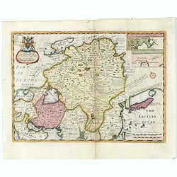
A New Map of Great Tartary and China with the adjoining parts of Asia
Two insets show the land to the northeast of China, according to Jesuit information. The map stretches from northern Russia and Nova Zemlya in the northwest to Formosa in...
Date: Oxford, 1700
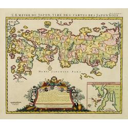
L'Empire du Japon, tire des cartes des Japonnois.
A good impression of this decorative map of Japan based on Reland's map of `1715, one of the earliest to use both Latin names and Japanese characters. With inset of the b...
Date: Amsterdam, 1719
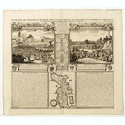
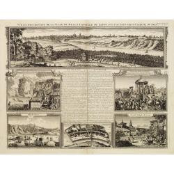
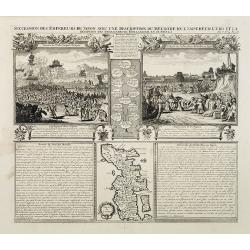
Succession Des Empereurs Du Japon Avec Une Description Du Meurtre De L'Empereur Cubo Et La Reception Des Ambassadeurs Hollandais. . .
The plate is showing the murder of the Emperor Cubo at Kyoto, the arrival of one of the early Dutch embassies.A small map of Honshu in a central panel. Plate from his &qu...
Date: Amsterdam, 1720
Vue et description de la Ville de Meaco Capitale du Japon. . .
The top part of the print shows a panoramic view of Meaco (Kyoto) at that time the capital of Japan, with a coach and horses in the foreground. Other parts show among oth...
Date: Amsterdam, 1720
Succession Des Empereurs Du Japon Avec Une Description Du Meurtre De L'Empereur Cubo Et La Reception Des Ambassadeurs Hollandais. . .
The plate is showing the murder of the Emperor Cubo at Kyoto, the arrival of one of the early Dutch embassies.A small map of Honshu in a central panel. Plate from his &qu...
- $400 / ≈ €349
Date: Amsterdam, 1720
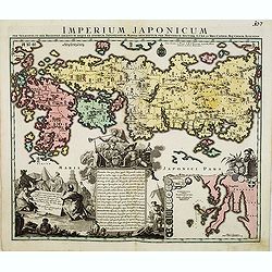
Imperium Japonicum.
The map is based on Engelbert Kaempfer's map of 1727. It shows a much-distorted outline for the Island of Japan and a wonderful decorative cartouche top left.Tobias Conra...
Date: Augsburg 1720

A Map of Turky, Arabia And Persia. Corrected from the latest Travels. . .
FIRST EDITION - Fine Turkish Empire map centered on Saudi Arabia, Cyprus and the Mediterranean Sea. Dated 1711, "Sold by John Senex at the Globe aga inst St. Dunstan...
- $1750 / ≈ €1529
Date: London, 1721
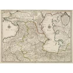
Carte des Pays Voisins de la Mer Caspiene dressee pour l' usage du Roy. . .
The map shows the area east of the Caspian Sea, including parts of Kazakhstan, Turkmenistan, Uzbekistan, and northern Iran. The area eastward from the Caspian is marked '...
- $750 / ≈ €655
Date: Paris, 1723
Platte Grond vande Stadt Macao.
A fine view of the city of Macao from Lappa Island showing in schematic blocks the structure of the town. With European vessels and junks in the surrounding water. With n...
Date: Amsterdam, 1724
De Stad Macao.
A fine view of the city of Macao from Lappa Island showing the defenses, the forts, churches and convents: including Fort de Baare, Bon Parto, Fort St Paulo (Monte Fort)....
Date: Amsterdam, 1724
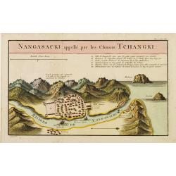
Nangasaki appellé par les Chinois Tchangki.
Attractive bird's-eye view of Nagasaki, with reference key to principal points of interest, including the Dutch V.O.C. Company House. The Dutch/Chinese enclave is central...
- $250 / ≈ €218
Date: Paris, 1727
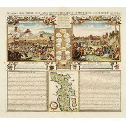
Succession Des Empereurs Du Japon Avec Une Description Du Meurtre De L'Empereur Cubo Et La Reception Des Ambassadeurs Hollandais En Ce Pays . . .
Composite sheet, with a small map of Japan and two detailed views: one depicting the murder of the Emperor Cubo, the other, the reception of the Dutch ambassadors, each w...
- $300 / ≈ €262
Date: Amsterdam, 1728
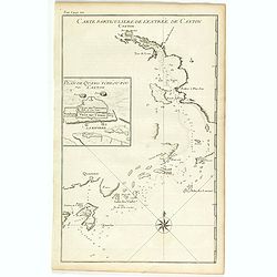
Carte particulière de l'entrée de Canton - Plan de Quang-tcheou-fou vulgo Canton .
Beautiful detailed map of the entrance to the city of Canton, showing also the cities of Macao and Quanghai, as well as the islands of the bay, including the island of Sh...
- $450 / ≈ €393
Date: Paris, P.G. Le Mercier, 1735
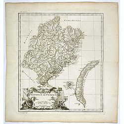
Province de Fo-Kien.
Important map of Fujian Province, showing the east coast of China and the west coast of Taiwan. The map shows for the Manchu Qing, only the western half of Formosa, whic...
Date: Paris, P.G. Le Mercier, 1735
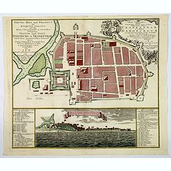
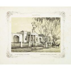
Grund=Riss und Prospect der Koniglichen Danischen auf der Kuste Choromandel in Ost-Indien belegenen Vestung und Stadt Dansburg u Trankenbar . . .
The Danish East India Company was founded in 1616. A first expedition was sent out in November 1618, which led to the purchase of a parcel of land on the Coromandel coast...
Date: Augsburg ca 1740
Constantinople ville de Romanie et capitale de l'Empire des Turcs.
A very decorative and extremely rare of Istanbul, including a numbered legend in lower part. Published by Jacques Chéreau, (1688 - 1776). Engraved by Aveline and first ...
Date: Paris, ca.1750

Manuscript map of the Bay of Nagasaki.
An extremely rare manuscript chart in brown ink and wash color on a printed sheet of paper with a system of rhumblines and latitude scales. This chart shows the Bay of Na...
Date: Amsterdam, 1750
Nieuwe kaart van Tartarie.
A map of Tartary, Korea and part of Japan. The map is most notable for the confusion between Kamchatka and Iesso.There are very good details of towns and trade routes in ...
Date: Amsterdam, 1750
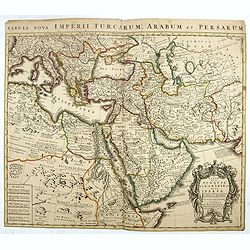
Carte de la Turquie de L'Arabie et de la Perse.
This is the Amsterdam issue of De L'Isle's map of the Turkish Empire and Arabian Peninsula. It includes the Turkish Empire, the Mediterranean, Central Asia, and parts of ...
Date: Amsterdam, 1751
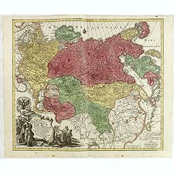
Spatiosissimum Imperium Russiae Magnae juxta recentissimas Observationes Mappa Geographica . . .
This is a decorative map of greater Russia, extending from Livonia in the west to Kamchatka, China, Tibet, Taiwan, Korea, and part of Japan in the east. To the south, it ...
- $1300 / ≈ €1136
Date: Augsburg, 1757
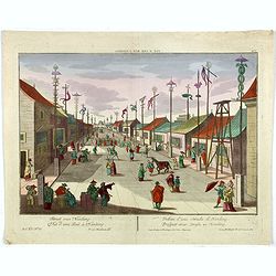
Vue d'une Rue Nanking.
A well-known publisher of optical prints, established in Augsburg. After a design by P.van Blankaert.In the eighteenth and nineteenth centuries, there were many popular s...
Date: Augsburg 1760
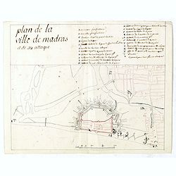
Plan de la ville de Madras et de ses attaques.
Manuscript map, in black, brown and red ink, showing the fortifications of the city of Madras, now Chennai, on the east coast of India, north of Pondicherry.Showing the c...
Date: Paris, ca 1760
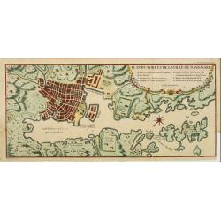
Plan du port et de la ville de Nangasaki.
This plan originates from Charlevoix's work Histoire et description Générele du Japon . His first in 1715 published work was the Histoire de l'etablissement du christia...
- $600 / ≈ €524
Date: Paris, 1760
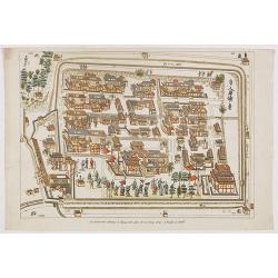
![Plan de Gingy, ville et forteresse d'Asie . . . [An Early Manuscript Map of Pondicherry Prior To Its Reconstruction After The Seven Years War.]](/uploads/cache/43006-250x250.jpg)
Plan de Gingy, ville et forteresse d'Asie . . . [An Early Manuscript Map of Pondicherry Prior To Its Reconstruction After The Seven Years War.]
An early manuscript map of Gingy shortly after The Seven Years War, when the French took possession of large part of India.With an extensive key to the left.Gingee Fort o...
- $1500 / ≈ €1310
Date: Paris, 1765
Plan de Thiagar, prise par l'arméé française en 1759.
An early manuscript map of Thiagar. With an extensive unfinished key to the left. The map was drawn shortly after the end of the Seven Years War, when the French took pos...
- $750 / ≈ €655
Date: Paris, 1769
Vue de la Pondichery dans les Indes Orientales
Pondicherry is the capital city of Indian union territory of Puducherry. Pondicherry is situated in Puducherry district of the union territory in India. The vue was produ...
Date: Paris, 1780
Alexandri Magni Imperium et Expeditio per Africam et potissimum per Aslam.
Rare map of the Empire of Alexander the Great, prepared by J.B.Nolin and published by Monhare for his Atlas Général a l'usage des colleges et maisons d'education.. Cent...
Date: Paris, 1783
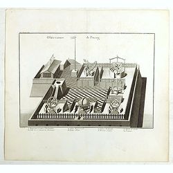
Observatoire de Peking.
The observatory of Mateo Rizzi in Peking, in which there are very large instruments, an Equinoctial Sphere, a Celestial Globe, a Zodiacal Sphere, Azimuthal Horizona, Quad...
Date: Paris, GROSIER Jean-Baptiste, 1785
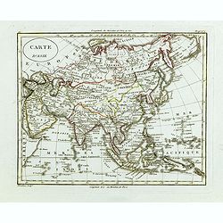
L'Asie divisée dan ses principaux états, empires, et royaumes dréssée et augmentée des plus exactes nouvelles découvertes qui ont fait en plusieurs fois les plus celebres capitaines.
A very rare map of Asia, in the style of Antonio Zatta with a scenic title cartouche, but folio-sized. It comes from a never-finished atlas by the ‘Società Calcografia...
Date: Venise, 1799
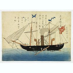
'Jokisen no zu' (Steamboat)
Nagasaki-e original Japanese woodblock print of a Steamboat. The figurehead is a striking detail.Nagasaki-e are Japanese woodblock prints that depict foreigners (Mostly ...
- $3750 / ≈ €3276
Date: Nagasaki, c.1805
Carte d'Asie.
Fine map of Asia, with an interesting representation of Japan, Hokkaido, Sakhalin Island, Kamchatka, and Korea. Engraved by Alexandre Blondeau, who also worked for Depôt...
- $175 / ≈ €153
Date: Paris, c. 1810
![Ansicht der stadt Nangasaky. [Nagasaki - title also in Russian characters]](/uploads/cache/24839-250x250.jpg)
Ansicht der stadt Nangasaky. [Nagasaki - title also in Russian characters]
A lively scene in Nagasaki harbor. In the foreground, Japanese junks and the town of Nagasaki in the background, with the warehouses on Deshima, the trading post of the D...
- $3000 / ≈ €2621
Date: St.Petersburg, 1810-1814
![Ansicht von Megasaky. [Nagasaki - title also in Russian characters]](/uploads/cache/24829-250x250.jpg)
Ansicht von Megasaky. [Nagasaki - title also in Russian characters]
The print shows Nagasaki harbor with n the foreground the Russian delegation with Krusenstern in a boat with 3 Chinese. Japanese junks and the town of Nagasaki in the ba...
- $1500 / ≈ €1310
Date: St.Petersburg, 1810-1814
La factorerie chinoise a nagasaki, dans la rue Teng-chan (fondée en 1688).
The Chinese traders at Nagasaki were confined to a walled compound which was located in the same vicinity as Dejima island; and the activities of the Chinese, though less...
- $500 / ≈ €437
Date: Paris, A. Nepveu, 1820
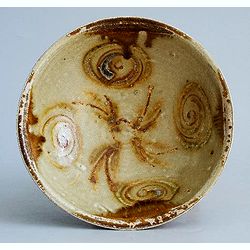
Tang Dynasty Changsha Bowl from the Belitung Wreck.
A beautiful Tang dynasty sancai glazed bowl made in Tongguan county, Changsha city, Hunan province of China mainly for export. Recovered from the Belitung shipwreck. This...
Date: China, Hunan province, 1826
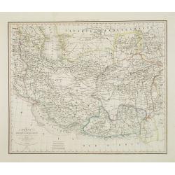
Perse Afghanistan et Balouchistan . . .
Detailed map of Irak and Iran, prepared by A. H. Basset, rue Saint-Jacques, no. 64, Paris and published in Atlas classique et Universel de Géographie . . . .The top thre...
Date: Paris, A.H. Basset, 1828
Tablaeu géographique statistique &C. de l'empire Russe actuel en Europe et en Asie avec ses aquisitions graduelles et caractérisées.
Map showing the extension of the Russian Empire at the beginning of the 19th century. Several letterpress notations are present on the map.Surrounding letterpress explana...
Date: Paris, Paul Renouard, 1828

A Chinese official with a ceremonial hat, holding a fan and a silk purse.
A colored wood block print of a Chinese official with a ceremonial hat, holding a fan and a silk purse.
Date: Nagasaki, c. 1830
Macao.
Early view of Macao after Barthelemy Lauvergne (1805-1875) and engraved in aquatint technique by Sigismond Himely (1801-1872). Published as plate 28 in Voyage autour du m...
- $600 / ≈ €524
Date: Paris, Finot, 1835
Carte physique et politique de l'Asie. Publiée pour la première fois en 1822 par J. GOUJON. Revue et augmentée par l'éditeur d'après de nouveaux matériaux.
This is a detailed map of Asie. It provides very good details of towns in modern-day Uzbekistan. The region is labeled as "Usbecs." The important cities on the...
Date: Paris, J. Goujon et J. Andriveau, 1837
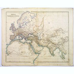
Orbis Veteribus Notus.
This is a detailed steel-engraved map of the ancient world, stretching from Europe eastwards to the Black Sea and beyond, southwards through northern Africa, Arabia, Indi...
Date: London, 1839
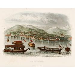
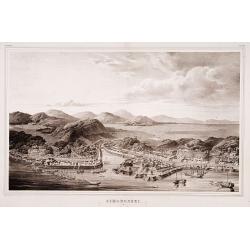
Vue de Nangasaki.
Steel-engraved view of Nagasaki from the water, identifying clearly Deshima, the V.O.C. trading post, and the Dutch flag. Japanese and Chinese sloops in the foreground. E...
- $125 / ≈ €109
Date: Paris, 1842
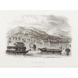
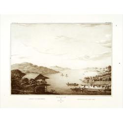
Vue de Nangasaki
View over the town from the water, identifying clearly Deshima with the V.O.C. trading post. Japanese sloops in the fore ground. Engraved by Alp.Boilly.
- $180 / ≈ €157
Date: Paris 1842
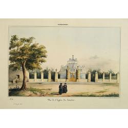
Pondichery - Vue de l'Eglise des Jésuites.
Constructed in 1791, it is regarded as the main mother church of Roman Catholic Archdiocese of Pondicherry and Cuddalore. To one’s surprise, this famous church in Pondi...
- $300 / ≈ €262
Date: Paris, 1843
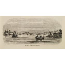
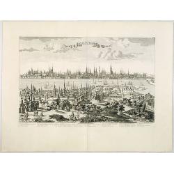
Der Hafen von Nangasaki auf Kiusiu.
A panoramic view of the harbour and city of Nagasaki with extensive shipping.
- $100 / ≈ €87
Date: Germany, 1847
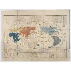
Chikyu Bankoku sankai yochi zenzu setsu. / Sekisui Cho Harutaka. (Map and description of geography of all the countries of the globe).
Reduced version of the famous map "Kaisei chikyu bankoku zenzu" by Sekisui Nagakubo (1717-1801) published ca. 1785, still based on the one by Matteo Ricci. Incl...
- $3500 / ≈ €3057
Date: Tokyo, 1850
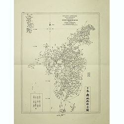
Insularum Japonicarum tabulae geographicae secundum opus NIPPON JO TSI RO TEI SEN TSU Tab. I Kiusui Insularum. . .
Fine map of the island if Kyushu, together with Tsushima Island with the bay of Nagasaki where in 1641 the man-made island of Deshima, trading post of the V.O.C. was est...
- $1000 / ≈ €874
Date: Leiden, 1832-1852
Simonoseki.
Bird's-eye view of Simonoseki, an important trading post in earlier times. Von Siebold was born in Wurtzburg, in Germany, and worked for the Dutch government as a doctor ...
- $1500 / ≈ €1310
Date: Leiden, 1832-1852
Gezicht op het Meer Tokaitç / Biwa-ko.
View of Lake Biwa near Kyoto.Von Siebold was born in Wurtzburg, in Germany, and worked for the Dutch government as a doctor in Java. In Japan, where Von Siebold arrived i...
- $1500 / ≈ €1310
Date: Leiden, 1832-1852
Factorij der Nederlanders op Firato.. 1609-1641.
Bird's-eye view of Hirado, a trading post of the V.O.C. from 1609 until 1641.Von Siebold was born in Wurzburg, in Germany, and worked for the Dutch government as a doctor...
- $1500 / ≈ €1310
Date: Leiden, 1832-1852
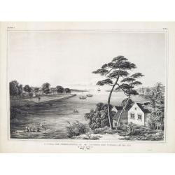
BATAVIA. Het post etablissement te Weltevreden. L'établissement des postes à Weltevreden.
Rare lithographed view of the post office at Weltevreden (Jakarta). Beautiful lithography drawn by Charles Th. Deeleman (1823 - 1884), lithographed by G.J. Bos and printe...
Date: Batavia, 1859-1860
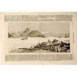
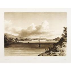
View of Nagasaki, Japan.
A panoramic view of Nagasaki harbour from the Illustrated Times of November 28th., 1863. With accompanying one column descriptive text on verso of Nagasaki.
- $100 / ≈ €87
Date: London, 1863

En Chine.
From the series "Caricatures du Prussien - Guerre des Duchés". Lithographed by Julés Pelcoq.
Date: Paris, 1864
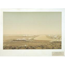
Attaque & prise des forts du Pei-Ho Le 21 Août 1860, par les troupes Françaises et Anglaises.
In 1860, an Anglo-French force gathered at Hong Kong and then carried out a landing at Pei Tang on August 1, and a successful assault on the Taku Forts on August 21.This ...
- $500 / ≈ €437
Date: Paris, ca.1865
