Browse Listings
Les Isles Britanniques. . .
Detailed map encompassing present day British Isles.Venetian edition of the map by Bellin, to whom Santini gives credit in the cartouche.From "Atlas Universel" ...
Date: Venice, 1776 - 1784
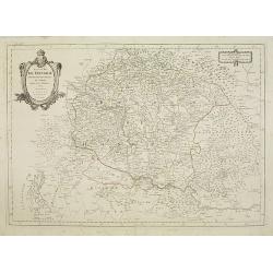
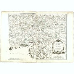
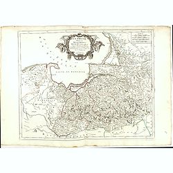
Royaume de Hongrie.
Detailed map encompassing present day Hungary with the river Danube and the towns of Belgrade, Budapest, Vienna, etc.Venetian edition of the map by Bellin, to whom Santin...
Date: Venice, 1776 - 1784
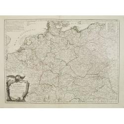
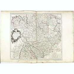
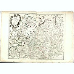
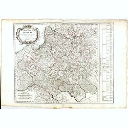
L'Empire d'Allemagne..
Detailed map encompassing Germany, the Netherlands, Belgium, Austria, and part of Poland.Venetian edition of the map by Bellin, to whom Santini gives credit in the cartou...
- $100 / ≈ €87
Date: Venice, 1776 - 1784
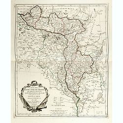
Principauté de Transilvanie et Pays circonvoisins..
Detailed map encompassing part of present-day Hungary.From "Atlas Universel" published by Santini in 1784. The atlas is effectively an Italian copy of the Rober...
Date: Venice, 1784
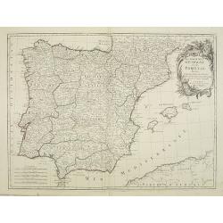
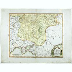
Les Royaumes d'Espagne et de Portugal, divisés Par Grandes Provinces..
Attractive map of the Iberian Peninsula. Ornated with a decorative title cartouche showing the coats of arms of Spain and Portugal.Prepared by Le Sieur Janvier, Jean deni...
- $200 / ≈ €173
Date: Venice, 1776 - 1784
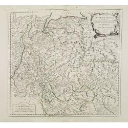
Duché de Savoye qui comprend..
Finely and crisply engraved map of Savoy. Venetian edition of de Vaugondy's map, from "Atlas Universel" printed in 1776-84.Large decorative title cartouche in t...
- $150 / ≈ €130
Date: Venice, 1776 - 1784
Graeciae Antiquae Specimen Geographicum..
A map of Greece in classical times, with an inset depicting northern Greece. Ornamental title cartouche in the lower left corner.Venetian edition of d'Anville's map, from...
- $250 / ≈ €216
Date: Venice, 1776 - 1784
Partie Meridionale du Cercle d'Autriche qui comprend La basse partie du Duché de Strie, Le Duché de Carinthie, divisé en haute et basse, Le Duché de Carniole. . . Et l'Istrie Impériale. . .
Uncommon, finely and crisply engraved map with large decorative title cartouche.Very detailed sheet that is centered roughly on Trieste and extends in to the mouth of the...
Date: Venice, 1784
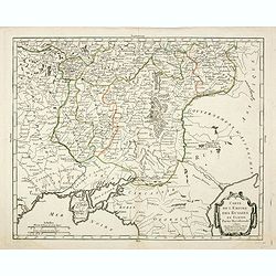
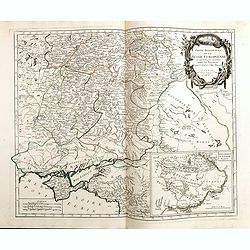
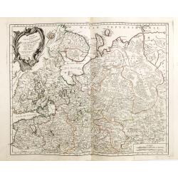
Partie Méridionale de la Russie Europeenne ou sont distinguees exactement toutes les Provinces, d'après le detail de l'Atlas Russien.
Detailed map of southern European Russia, including Yugoslavia. The map was first published by the Venetian cartographer and publisher François (Père) Santini and first...
Date: Venice, 1784
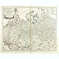
Partie Septentrionale de la Russie Europeenne ou sont distinguees exactement toutes les Provinces, d'apres le detail de l'Atlas Russien, Par le Sr. Robert de Vaugondy fils, Geog. Ordin? Du Roi.
Detailed map of northern European Russia, including Finland. The map was first published by the Venetian cartographer and publisher François (Père) Santini and first pu...
Date: Venice, 1784
Il Paesi Bassi Austriaci, che comprendono parte delle Flandre, del Haynault, e del Brabante.
Uncommon map of Flanders and Brabant in present-day Belgium. Embellished with a nice title-cartouche. Engraved by G.Pitteri after G.Zuliani.From his Atlante Novissimo, il...
- $140 / ≈ €121
Date: Venice, 1784
Carte de l'empire des Russies en Europe partie meridionale
Uncommon and detailed map of Ukraine.Published by Pierre Bourgoin in 1784 in his uncommon "Atlas Élémentaire de la Géographie", published at rue de la Harpe ...
- $300 / ≈ €260
Date: Paris, 1784
Partie Occidentale de l'Empire de Russie en Asie. . .
Finely and crisply engraved map of the north-western part of Russia, with noteworthy topographical detail.Ornamental title cartouche in the upper left corner surrounded w...
- $300 / ≈ €260
Date: Venice, 1776 - 1784
Partie Méridionale de la Russie Europeenne ou sont distinguees exactement toutes les Provinces, d'après le detail de l'Atlas Russien.
Detailed map of southern European Russia, including Yugoslavia. The map was first published by the Venetian cartographer and publisher François (Père) Santini and first...
- $600 / ≈ €519
Date: Venice, 1784
Carte de la Lithuanie Russienne qui comprend les Palatinats de Livonie, de Witepsk, de Miscislaw, et une partie de ceux de Polock et de Minsk cédés par la Pologne à la Russie.
Detailed map of the areas along the river Dnieper and Duna. Santini gives credit to Homann Heirs in the cartouche. The map was prepared by the Venetian cartographer and p...
- $500 / ≈ €433
Date: Venice, 1776 - 1784
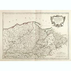
Carte De La Prusse Occidentale ou sont tracees les Provinces cedees Par la Pologne au Roi De Prusse . . . 1775
Finely and crisply engraved map of Western Prussia, now part of Poland on the Baltic Sea, including the Bay of Danzig. With ornamental title cartouche and noteworthy topo...
- $375 / ≈ €325
Date: Venice, 1776 - 1784
La Prusse divisée en Prusse Royale et Prusse Ducale.
The map extends from Memem, Danzig and Rosienne in the North to Novigrod in the southeast and Thorn on the Wessel in the southwest. Shows the Gulf of Danzig and part of P...
- $300 / ≈ €260
Date: Venice, 1776 - 1784
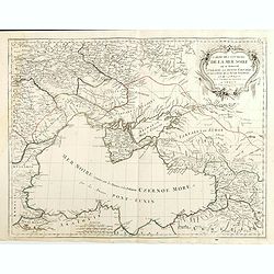
Carte des environs de la Mer Noire. . .
Finely and crisply engraved map centered on Crimea, showing the Black Sea and its hinterland.Noteworthy topographical detail is shown. Decorative title cartouche in the u...
- $500 / ≈ €433
Date: Venice, 1776 - 1784
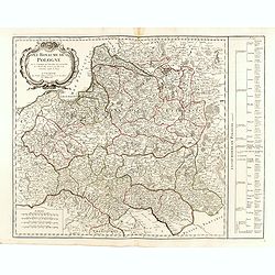
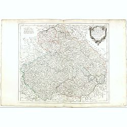
Royaume de Pologne.
Detailed map encompassing present-day Poland.Venetian edition of the map by R. de Vaugondy, to whom Santini gives credit in the cartouche.From "Atlas Universel"...
- $400 / ≈ €346
Date: Venice, 1776 - 1784

L'Asie divisée en ses principaux Etats..
A finely and crisply engraved map of Asia is decorated with an ornamental title cartouche in the lower-left corner.There are very good details of towns in modern-day Uzbe...
Date: Venice, 1776 - 1784
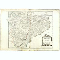
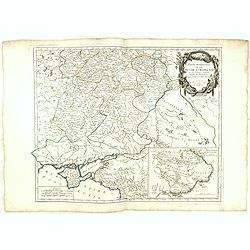
Etats de la Couronne d'Aragon...
Detailed map of the eastern part of Spain. Numerous place-names of counties, cities, towns, physical features.Prepared by "Robert de Vaugondy fils," to whom San...
- $150 / ≈ €130
Date: Venice, 1776 - 1784
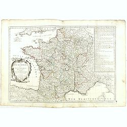
Le Royaume de France. . .
Decorative map of France with large title cartouche and a list of the "Provinces de France".Prepared by Le Sieur Janvier, Jean denis [Robert], a French geograph...
- $150 / ≈ €130
Date: Venice, 1776 - 1784
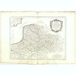
Gouvernements de Flandre Françoise, d'Artois, de Picardie. . .
Detailed map encompassing northwestern part of France, with the Channel and tip of southern England. With ornamental title cartouche and noteworthy topographical detail.T...
- $100 / ≈ €87
Date: Venice, 1776 - 1784
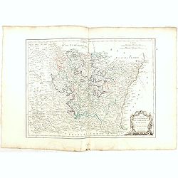
Gouvernement de l'Isle de France et de celui de l'Orléanois. . .
Detailed map encompassing present day north of France.Venetian edition of the map by Bellin, to whom Santini gives credit in the cartouche.From "Atlas Universel"...
- $100 / ≈ €87
Date: Venice, 1776 - 1784
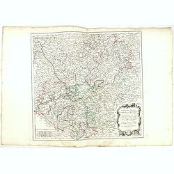
Gouvernements de Champagne et Brie.
Detailed map encompassing Champagne and Brie.Venetian edition of the map by Bonne, to whom Santini gives credit in the cartouche.From "Atlas Universel" publishe...
- $75 / ≈ €65
Date: Venice, 1776 - 1784
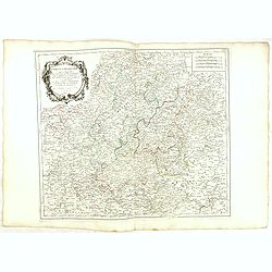
Gouvernements de Lorraine et d'Alsace.
Detailed map encompassing present day the east of France.Venetian edition of the map by Bonne, to whom Santini gives credit in the cartouche.From "Atlas Universel&qu...
- $100 / ≈ €87
Date: Venice, 1776 - 1784
Carte des Cercle du Haut et du Bas Rhin.. avec leurs enclaves.
Finely and crisply engraved map of Germany showing the river Rhine, including Duisburg, Spire, Mannheim, etc.With ornamental title cartouche and noteworthy topographical ...
- $75 / ≈ €65
Date: Venice, 1776 - 1784
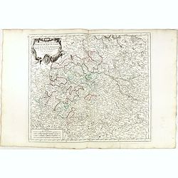
Cercle de Franconie.. Reineck d' Erpach.
Finely and crisply engraved map, centered on Schweinfurt, Bamberg and Nuremberg.With ornamental title cartouche and noteworthy topographical detail.The map was prepared b...
- $100 / ≈ €87
Date: Venice, 1776 - 1784
Partie Méridionale de la Russie Europeenne ou sont distinguees exactement toutes les Provinces, d'après le detail de l'Atlas Russien.
Detailed map of southern European Russia, including Yugoslavia. The map was first published by the Venetian cartographer and publisher François (Père) Santini and first...
- $400 / ≈ €346
Date: Venice, 1784

Carte de la Pologne Autrichienne contenant La Russie Rouge et la partie méridionale du Palatinat de Cracovie . . .
Detailed map with Krakow, including the areas of Malopolskie and Podkarpackie and including present-day Ukraine.Santini gives credit to Homann Heirs in the cartouche. Mal...
- $300 / ≈ €260
Date: Venise 1776-1784
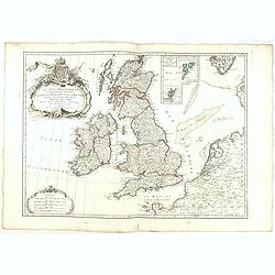
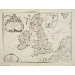
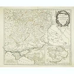
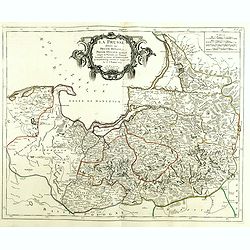
Les Isles Britanniques Comprenant les Royaumes D'Angleterre, D'Ecosse et D'Irlande divisée en grands provinces. . .
Detailed map encompassing present day British Isles. An inset in the upper right details the Shetland and Orkney Islands. Venetian edition of the map by Janvier, to whom ...
- $200 / ≈ €173
Date: Venice, 1776 - 1784
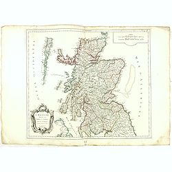
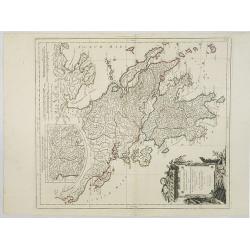
L'Ecosse divisée en Shires et Comtés.
Finely and crisply engraved map of Scotland.Venetian edition of Giles Didier Robert De Vaugondy's map from Atlas Universel printed in 1776-84.Ornamental title cartouche i...
- $250 / ≈ €216
Date: Venice, 1776 - 1784
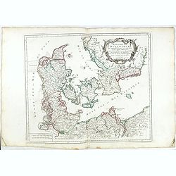
Royaume de Danemarck. qui comprend le Nort-Jutland . . . Sélande, Laland.
Finely and crisply engraved map of Denmark. Venetian edition of Giles Didier Robert De Vaugondy's map from Atlas Universel printed in 1776-84. Ornamental title cartouche ...
- $100 / ≈ €87
Date: Venice, 1776 - 1784
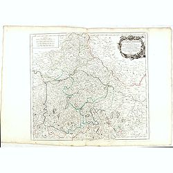
Le cercle De Baviere.. et la prevoté de Berchtolsgaden.
Finely and crisply engraved map centered on Regensburg, including some great skiing resort areas of Austria and part of Germany, centered on Passau, Ingollstat, Salzburg....
- $100 / ≈ €87
Date: Venice, 1776 - 1784
Partie Meridionale du Cercle d'Autriche qui comprend La basse partie du Duché de Strie, Le Duché de Carinthie, divisé en haute et basse, Le Duché de Carniole. . . Et l'Istrie Impériale. . .
Uncommon, finely and crisply engraved map with large decorative title cartouche.Very detailed sheet that is centered roughly on Trieste and extends in to the mouth of the...
- $100 / ≈ €87
Date: Venice, 1784
Le Royaume de Boheme.. Moravie et Lusace.
Finely and crisply engraved map of Czechoslovakia, including Pilsen and part of Poland.Venetian edition of Giles Didier Robert De Vaugondy's map from Atlas Universel prin...
- $150 / ≈ €130
Date: Venice, 1777 - 1784
Cercle de Haute Saxe.
Finely and crisply engraved map of Germany, centered on Leipzig. From Atlas Universel printed in 1776-84.With ornamental title cartouche and noteworthy topographical deta...
- $75 / ≈ €65
Date: Venice, 1776 - 1784
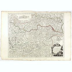
Cercle de Basse Saxe où sont distingués les états de ... et des évêchés d'Hildesheim et d'Halberstadt par le Sr. Robert.
Finely and crisply engraved map of northern part of Germany, including the river Elbe, with Hamburg until Potsdam. In the upper right the Baltic coast including Wismar, R...
- $100 / ≈ €87
Date: Venice, 1776 - 1784
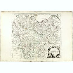
Cercle de Westphalie divisé en tous ses Etats et Souverainetés.
Finely and crisply engraved map of central Germany, including the river Rhine from Deventer till Bonn, with Dusseldorf. In upper left , inset of the area of Emden until O...
- $100 / ≈ €87
Date: Venice, 1776 - 1784
Partie meridionale des Pays Bas.. Cambrefis et Artois.
Finely and crisply engraved map of Belgium, including southern part of Netherlands and part of Germany.Venetian edition of Giles Didier Robert De Vaugondy's map from Atla...
- $100 / ≈ €87
Date: Venice, 1776 - 1784
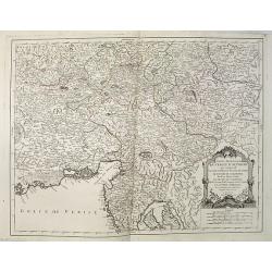
Partie Septentrionnale du Cercle d'Autriche.. Duché de Stirje.
Finely and crisply engraved map of Austria, centered on Vienna.Venetian edition of Giles Didier Robert De Vaugondy's map from Atlas Universel printed in 1776-84.With orna...
- $100 / ≈ €87
Date: Venice, 1776 - 1784
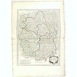
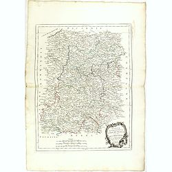
Gouvernements de Berri, du Nivernois,de la Marche, Limousin..
Detailed map encompassing Berri, Nivernois, Limousin and Auvergne.Venetian edition of the map by Bonne, to whom Santini gives credit in the cartouche.From "Atlas Uni...
- $75 / ≈ €65
Date: Venice, 1776 - 1784
Partie Septentrionale de la Russie Europeenne ou sont distinguees exactement toutes les Provinces, d'apres le detail de l'Atlas Russien, Par le Sr. Robert de Vaugondy fils, Geog. Ordin? Du Roi.
Detailed map of northern European Russia, including Finland. The map was first published by the Venetian cartographer and publisher François (Père) Santini and first pu...
- $250 / ≈ €216
Date: Venice, 1784
La Prusse divisée en Prusse Royale et Prusse Ducale.
The map extends from Memem, Danzig and Rosienne in the North to Novigrod in the southeast and Thorn on the Wessel in the southwest. Shows the Gulf of Danzig and part of P...
Date: Venice, 1776 - 1784
Carte de l'empire des Russies en Europe partie meridionale
Uncommon and detailed map of Ukraine.Published by Pierre Bourgoin in 1784 in his uncommon "Atlas Élémentaire de la Géographie", published at rue de la Harpe ...
- $350 / ≈ €303
Date: Paris, 1784
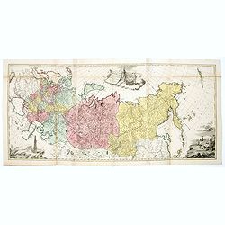
Tabula geographica generalis Imperii Russici ad normam novissimarum observationum astronomicarum concinnata. . .
Important three-sheet map of the Russian Empire under Catherine the Great. This map was first published in St Petersburg in 1775.Scale cartouche is decorated with a rocky...
- $2200 / ≈ €1904
Date: Augsburg, C.Lotter, c.1784
Royaume de Pologne.
Detailed map encompassing present-day Poland. The table provides a breakdown of the sub-regions of the Polish Crown.Venetian edition of the map by R. de Vaugondy, to whom...
- $350 / ≈ €303
Date: Venice, 1776 - 1784

Plan de St. Jean de Luz avec les différents projets d'agrandissem.t du port.
Very rare and beautiful plan of the city and bay of Saint-Jean-de-Luz, detailing the projects of expansion of the port undertaken in 1780.The plan indicates the Artha Roc...
- $2200 / ≈ €1904
Date: Paris, 1784
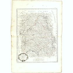
Gouvernements de Bourgogne, de Franche Comté et de Lyonnois.
Detailed map encompassing Bourgogne, Franche Comté and Lyonnois.Venetian edition of the map by Bonne, to whom Santini gives credit in the cartouche.From "Atlas Univ...
- $100 / ≈ €87
Date: Venice, 1776 - 1784

Carte De La Prusse Occidentale ou sont tracees les Provinces cedees Par la Pologne au Roi De Prusse . . . 1775
Finely and crisply engraved map of Western Prussia, now part of Poland on the Baltic Sea, including the Bay of Danzig. With ornamental title cartouche and noteworthy topo...
Date: Venice, 1776 - 1784
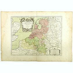
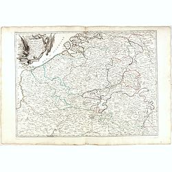
Les Dix-Sept Provinces des Pays-Bas. . .
Map of the present-day Benelux by L.C. Desnos. Engraved by Cordier.
- $100 / ≈ €87
Date: Paris, 1784
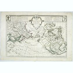
Carte des nouvelles decouvertes au Nord de la Mer du Sud.
Although concentrating on the northern Pacific, this map shows all of North America and Mexico.While the Russian coastline is shown with reasonable accuracy, notwithstand...
- $1800 / ≈ €1558
Date: Venice, 1776 - 1784
Partie Septentrionale de la Russie Europeenne ou sont distinguees exactement toutes les Provinces, d'apres le detail de l'Atlas Russien, Par le Sr. Robert de Vaugondy fils, Geog. Ordin? Du Roi.
Detailed map of northern European Russia, including Finland. The map was first published by the Venetian cartographer and publisher François (Père) Santini and first pu...
Date: Venice, 1784
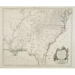
Partie Méridionale de la Louisiane, avec la Floride, la Caroline et la Virginie..
Fine map of southeastern part of the United States after d'Anville's, to whom Santini gives credit in the cartouche.It covers the Atlantic coastline between the Chesapeak...
Date: Venice, 1776 - 1784

Red Flamingo.
Original hand-colored copper engraving representing a Red Flamingo from General Synopsis of Birds by John A. Latham (1740-1837) who was the prominent ornithologist of his...
- $100 / ≈ €87
Date: London 1781-1785
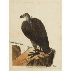
Bengal. Vulture, N.° 16.
Original hand-colored copper engraving representing a Bengal Vulture from General Synopsis of Birds by John A. Latham (1740-1837) who was the prominent ornithologist of h...
- $90 / ≈ €78
Date: London, 1781-1785

Green Partridge.
Original hand-colored copper engraving representing a Green Partridge from General Synopsis of Birds by John A. Latham (1740-1837) who was the prominent ornithologist of ...
- $150 / ≈ €130
Date: London 1781-1785

Hackled Partridge.
Original hand-colored copper engraving representing a Hackled Partridge from General Synopsis of Birds by John A. Latham (1740-1837) who was the pre?eminent ornithologist...
- $150 / ≈ €130
Date: London, 1781-1785
![[Title page] Atlante Novissimo, illustrato ed accresciuto . . .](/uploads/cache/27515-250x250.jpg)
[Title page] Atlante Novissimo, illustrato ed accresciuto . . .
Decorative Venitian frontispiece from Antonio Zatta's Atlas Atlante Novissimo, illustrato ed accresciuto . . . . The outer decoration of this title page has a wealth of c...
- $230 / ≈ €199
Date: Venice, 1785
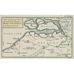
Post-Route von Brüssel nach Gent, Brügge, Ostende, nach Antwerpen und Bergen op Zoom. N°XXIII
Very rare post route maps map centered on Gent, and showing the postal routes in-between Oostende, Bruges, Gent, Brussels, Mechelen, Lier, Antwerp, Bergen op Zoom, etc. f...
- $250 / ≈ €216
Date: Nürnberg, Weigel and Schneider, ca.1785
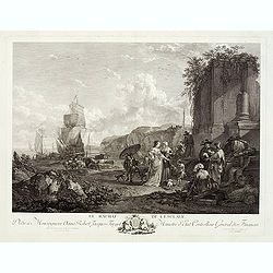
Le Rachat de l'Esclave.
With a dedication to Monseigneur Anne Robert Jacques Turgot Ministre d'Etat, Controlleur Général des Finances. Engraved by J. Aliamet (1726-1788) after Nicolaes Pieters...
- $300 / ≈ €260
Date: Paris, Aliamet, ca. 1785
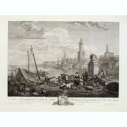
Embarquement de vivres.
With a dedication to Monseigneur le Comte de Saint Florentin Commandeur des Ordres du Roy. Engraved by Jac. Philippe Le Bas, who was also engraver for "Cabinet du Ro...
- $500 / ≈ €433
Date: Paris, ca. 1785

Carte de la Petite Tartarie Dresee par ordre de l'Imperatries de toutes las Russies.
The very rare first edition of De Leth's map of the southern part of Ukraine, with detailed annotations regarding the Cossacks and an explanatory key. Based on a Russian ...
- $1750 / ≈ €1515
Date: Amsterdam, ca. 1785
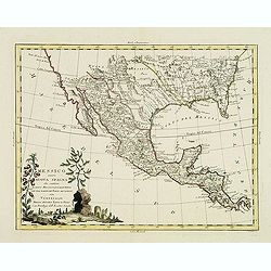
Messico ouvero Nuova Spagna che contiene Il Nuova Messico La California con una Parte de Paesi Adjacenti. . .
Decorative and detailed map of Mexico, Texas, Florida, Louisiana, and Central America. The map is filled with remarkable detail throughout, particularly in Texas, New Mex...
Date: Venise, 1785
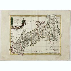
L'Impero del Giapon diviso in sette principali parti cive..
The map of the Japanese Empire published by Antonio Zatta (1757-97) continued to show most of the inaccuracies of earlier eighteenth-century maps.
Date: Venice, 1785
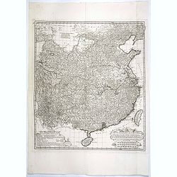
Carte Generale de la Chine Dressée sur les Cartes Particulieres Que l' Empereur Chang-Hi a fait lever sur les lieux..
Large map showing the traditional limits of China, including Hainan and Formosa in the South, and Quantong and parts of the Gobi Desert in the North.As the title notes, t...
Date: Paris, Ph.-D. Pierres, Clousier [- Moutard], 1785
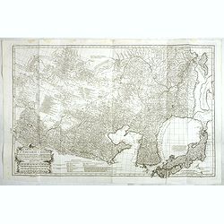
Carte Generale De La Tartarie Chinoise Dressee sur les Cartes Particulieres Faits Sur Les Lieux Par Les R.R. P.P. Jesuites . . . .MDCCXXXII
This is a very detailed map of the region from Japan to the Gobi Desert, centered on Mongolia and Korea, from D'Anville's Atlas of China. Jean Baptiste Bourguignon d' Anv...
Date: Paris, Ph.-D. Pierres, Clousier [- Moutard], 1785
![[Set of 4 maps] Indie Orientali di Quà e di la Dal Gange col Loro Arcipelago.](/uploads/cache/36680-250x250.jpg)
[Set of 4 maps] Indie Orientali di Quà e di la Dal Gange col Loro Arcipelago.
Fine almost wall sized map of South east Asia, including Formosa, New Guinea, the Maldives and the Indus delta. From his "Atlante Novissimo, illustrato ed accresciut...
- $850 / ≈ €736
Date: Venice, ca. 1779 - 1785
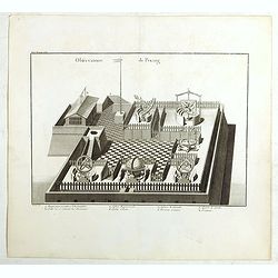
Observatoire de Peking.
The observatory of Mateo Rizzi in Peking, in which there are very large instruments, an Equinoctial Sphere, a Celestial Globe, a Zodiacal Sphere, Azimuthal Horizona, Quad...
Date: Paris, GROSIER Jean-Baptiste, 1785
![Indie Orientali di Quà e di la Dal Gange col Loro Arcipelago. [Set of 4 maps]](/uploads/cache/43240-250x250.jpg)
Indie Orientali di Quà e di la Dal Gange col Loro Arcipelago. [Set of 4 maps]
Fine almost wall sized map of South east Asia, including Formosa, New Guinea, the Maldives and the Indus delta. From his "Atlante Novissimo, illustrato ed accresciut...
Date: Venice, ca. 1779 - 1785
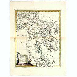
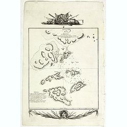
Regni D'Aracan Del Pegu Di Siam Di Camboge E Di Laos . . . 1785
Striking regional map centered on Thailand and Vietnam, extending from the Singapore to India, and north to Tibet. Decorative scroll title cartouche.
- $500 / ≈ €433
Date: Venise, 1785
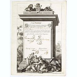
A scarce Real Compañia de Filipinas 250 Pesos deed issued in 1785.
A scarce Real Compañia de Filipinas 250 Pesos deed issued in 1785. Share nº 24665, hand signed by several company officials.Engraved by Fernando Selma (1752-1810) after...
Date: Spain, 1785
Sketch of the Typa and Macao.
A map of the environs of the Portuguese settlement of Macao in the Far East. The map shows a small town plan of Macao, nearby rocks, shoals depth soundings, and a few nav...
- $150 / ≈ €130
Date: London, 1785
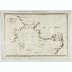
Carte de l'Entrée de Norton, et du Detroit de Bhering ou Von vou le Cap le plus oriental de l'Asie, et la Pointe la plus occidentale de l'Amerique.
Early detailed map of the passage between Asia and the NW Coast of America, including nice topographical details and the day by day tracks of Cook through the region in 1...
- $300 / ≈ €260
Date: Paris, 1785

Amérique Septentrionale .. Les Etats Unis..
Very rare state: probably separately issued. Published the same year as the Treaty of Paris, this is one of the first maps to show printed boundary lines for the newly...
- $3000 / ≈ €2596
Date: Paris, 1786
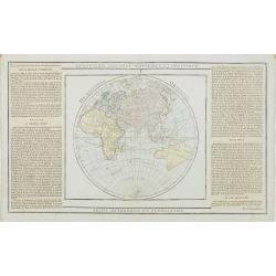
Hémisphère Oriental..
Map of the Eastern Hemisphere, including numerous exploration routes with a notation of important recent discoveries.Australia is partially mapped and then completed into...
- $150 / ≈ €130
Date: Paris, 1786
![[Frontispiece] Atlas Général et Elémentaire Pour l'Etude de la Géographie et de l'Histoire moderne..](/uploads/cache/24168-250x250.jpg)
[Frontispiece] Atlas Général et Elémentaire Pour l'Etude de la Géographie et de l'Histoire moderne..
Allegoric frontispiece, from Atlas Général et Élémentaire pour l'Etude de la Géographie et de l'Histoire moderne. Engraved by K.Audran.
Date: Paris, 1786
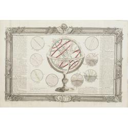
De la Sphère. L'equateur. Des Tropiques. Le zodiac. Les cercles polaires. L'Horizon. Le meridian.
Print of armillary sphere, surrounded by several diagrams of the sun, moon, and planets after Cassini. To the left and right 7 blocks of text with explanations and one co...
Date: Paris, 1787
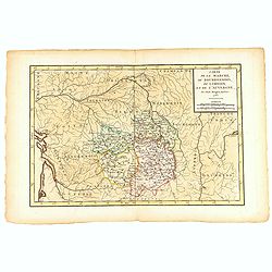
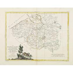
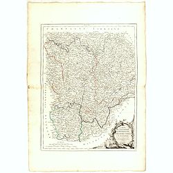
Carte de la Marche, du Bourbonnois, de Limousin, et de l'Auvergne.
Very fine map of Auvergne, Limousin, Bourbonnois and Marche regions in France. Engraved by Ballet and included in the rare atlas "Atlas Universelle" by Philippe...
- $150 / ≈ €130
Date: Paris, 1787
![[Title page] Atlas Géographique et Universel . .](/uploads/cache/47743-250x250.jpg)
[Title page] Atlas Géographique et Universel . .
Title page of Atlas Géographique et Universel by Guillaume De L'Isle and Philippe Buache in 1787, published by Jean-Claude Dezauche.More about title pages [+]
- $350 / ≈ €303
Date: Paris, 1787