Browse Listings
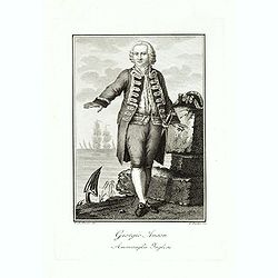
Giorgio Anson Ammiraglio Inglese.
Copper engraved portrait of George Anson, 1st Baron Anson PC, FRS, RN (23 April 1697 – 6 June 1762), engraved by L. Rados after G.B.Bosio.Anson was a British admiral an...
- $300 / ≈ €260
Date: Ca. 1800
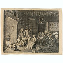
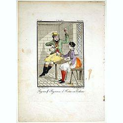
(Interior scene)
Lively interior scene with the men sitting together and drinking around a table whilst the women look after the children, weave hay and the older children cooking. Engrav...
- $100 / ≈ €87
Date: Paris, ca. 1800
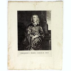
Theodorus Primus Corsicae Rex.
Portrait of Everard Jabach, three-quarter length, standing by the fragment of a column, facing left, wearing a cloak and doublet with plain collar, his left arm held behi...
Date: Paris, 1652 - 1800
![[Title page] AtlasGeneral Méthodique et Elémentaire . . .](/uploads/cache/48054-250x250.jpg)
[Title page] AtlasGeneral Méthodique et Elémentaire . . .
Title page from Atlas general Méthodique et Elémentaire. Very fine, typical French title page, published with Desnos.
Date: Paris, 1800
![[Portrait of Nicolas Louis de La Caille].](/uploads/cache/47704-250x250.jpg)
[Portrait of Nicolas Louis de La Caille].
Portrait of Nicolas Louis de La Caille, also known as L'Abbé De La Caille, engraved by Thérèse Devaux.
- $75 / ≈ €65
Date: Paris, ca. 1800
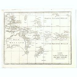
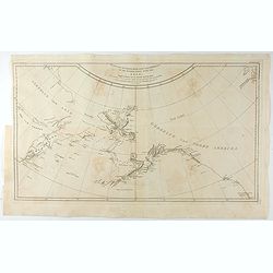
A Chart exhibiting the New Discoveries in the North & south Pacific Ocean.
A scarce map, probably from an English travel journal, produced in the late eighteenth century, showing the latest cartographic discoveries within the Pacific region. Map...
Date: London, ca. 1800

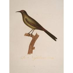
Le Go-Ruck.
An attractive representation of a bird by François Levaillant publisher in Paris 1801 in Histoire naturelle d'une partie d'oiseaux nouveaux et rares de l'Amérique et de...
Date: Paris 1801
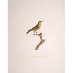
Le S. a Cinture Marron.
An attractive representation of a bird by François Levaillant publisher in Paris 1801 in Histoire naturelle d'une partie d'oiseaux nouveaux et rares de l'Amérique et de...
Date: Paris 1801

La Méesange Brune Male. La Méesange Grise. . .
Very decorative plate from Histoire naturelle des oiseaux d'Afrique, published by Delachaussée. Levaillant's interest in natural history led him to explore Africa as the...
- $150 / ≈ €130
Date: Paris, 1801

L'Acoli.
Very decorative plate from Histoire naturelle des oiseaux d'Afrique, published by Delachaussée. Levaillant's interest in natural history led him to explore Africa as the...
- $230 / ≈ €199
Date: Paris, 1801
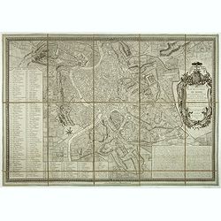
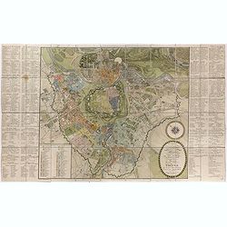
Plan de la ville de Rome, d'après celui publié par J.B. Nolli . . .
Beautiful town-plan of Rome, drawn up after the famous plan of Rome, executed by Giambattista Nolli in 1748. Decorated with a beautiful title cartouche topped by the coat...
- $1000 / ≈ €865
Date: Paris, Jean, 1801
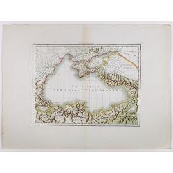
Carte de la Mer Noire ou Kara Degniz.
Original antique copper engraved map of the Black Sea with attractive original hand coloring.
- $200 / ≈ €173
Date: Paris, 1791-1801
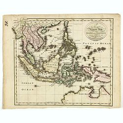
A new and Accurate map of the islands and Channels between China and New Holland.
Highly detailed map of Southeast Asia, covering the region between Formosa and Hainan islands in the North and Australia in the South.Including Burma to Taiwan with parts...
- $600 / ≈ €519
Date: Edinburgh, 1801
Kaart van de Noord-West kust van Amerika en de Noord-Oost kust van Asia. . .
A uncommon issue of this important map of the Northern Pacific and contiguous coasts of America and Asia, published in 'Reize rondom de Waereld door James Cook', a Dutch ...
- $1000 / ≈ €865
Date: Leyden, Amsterdam & The Hague: Honcoop, Allart & van Cleef, 1795-1801

L'Heoro-taire brun. Pl.65.
A very rare print of a humming bird from Histoire naturelle et générale des colibris, oiseaux-mouches, jacamars et promerops, by Jean Baptiste Audebert. Before his deat...
- $230 / ≈ €199
Date: Paris, 1800-1802

Le G. G. Noir et Bleu.
A very rare print of a humming bird from Histoire naturelle et générale des colibris, oiseaux-mouches, jacamars et promerops, by Jean Baptiste Audebert. Before his deat...
- $230 / ≈ €199
Date: Paris, 1800-1802
Le Neghôbàrra. Pl.64
A very rare print of a bird from Histoire naturelle et générale des colibris, oiseaux-mouches, jacamars et promerops , by Jean Baptiste Audebert. Before his death Audeb...
- $230 / ≈ €199
Date: Paris, 1800-1802
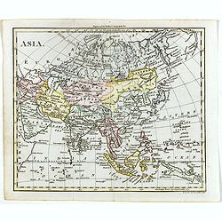
Asia.
The map is of interest for the use of Gulf of Corea, the sea between Korea and Japan.William Darton, Sr. started his mapmaking business in 1787 in London, and thus began ...
- $300 / ≈ €260
Date: London, 1802
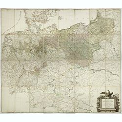
General Karte von den saemtlichen Kšnig. Preussischen Staaten welche zugleich als POSTKARTE durch die Länder der Preussischen Monarchie und durch ganz Deutschland diendt. . .
Large wall map (1,25 x 1,38 meters) of Prussia and present-day Poland, prepared by D.F. Sotzmann and published by Königl. Preuss. Academie Kunst und Buchhandlung.A detai...
- $1500 / ≈ €1298
Date: Berlin, 1802
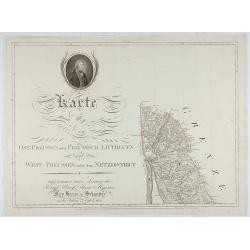
Karte von Ost-Preussen nebst Preussisch Litthauen und West-P
The title section of this important multi-sheet map of Prussia, Lithuania and Poland, showing territories of present Lithuania. With a medallion representing the King of ...
Date: Berlin, 1802
![[Title page] Atlas de la République Française. . .](/uploads/cache/47741-250x250.jpg)
[Title page] Atlas de la République Française. . .
Title page of Atlas de la République Française by Pierre Gilles Chanlaire in 1802.
- $150 / ≈ €130
Date: Paris, 1802
![[Lot of 5 maps] Kaart van de noord-west kust van Amerika en de noord-oost kust van Asia.](/uploads/cache/19136-250x250.jpg)
[Lot of 5 maps] Kaart van de noord-west kust van Amerika en de noord-oost kust van Asia.
- Kaart van de noord-west kust van Amerika en de noord-oost kust van Asia. Opgenoomen in de Jaaren 1778 en 1779. Captain James Cook (1728-79), explorer, circumnavigato...
Date: Leiden, 1795-1803
![[2 maps] Des europäischen Russlands nördlicher Theil. / Des europäischen Russlands sûdlicher Theil.](/uploads/cache/34707-250x250.jpg)
[2 maps] Des europäischen Russlands nördlicher Theil. / Des europäischen Russlands sûdlicher Theil.
Detailed map of Russia in two sheets, published by Johannes Wach of Augsburg.
- $250 / ≈ €216
Date: Augsburg, 1803
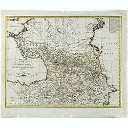
Charte der Laender am Caucasus nach dem besten vorhanden Charten, Reisen, und astronomischen Ortbestimungen gezeichnet von I.C.Reinecke .
Scarce map of the Ukraine and Caucasus filled with great topographical detail, as well as numerous place names. According to the title the map has been drawn by Johann Ma...
- $750 / ≈ €649
Date: Weimar, 1803
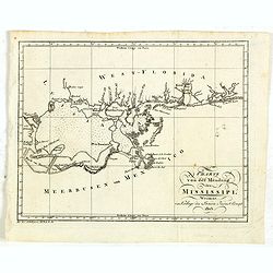
Charte von der mündung des Mississippi. Weimar, Verlage des Landes Indust. Compt. 1803.
Scarce map showing the mouth of the Mississippi into the Gulf of Mexico. With Pensacola in Western Florida, Mobile Bay in Alabama and Louisiana with New Orleans and their...
- $300 / ≈ €260
Date: Weimar, 1803

Jean Denys Barbieé du Bocage Geograph des Franz. Ministeriums der auswärtigen Angelegenheiten.
Stipple engraved portrait of Jean Denis Barbie du Bocage (1760 - 1825), probably engraved by Conrad Westermayr.Jean Denys Barbieé was a French cartographer active in Par...
- $300 / ≈ €260
Date: Hanau, ca. 1803
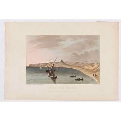
Déde, near Tripoli.
Showing a few boats and harbour in Déde near Tripoli in Libanon, sketched on the spot by F.B. Spilsbury and drawn by D. Orme for "Picturesque Scenery in the Holy La...
- $75 / ≈ €65
Date: London, 1803
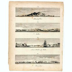
Island of Elba / Malta / Inner harbour of Malta / Alexandria.
Four views on a sheet, engraved by S.I Neele. Profile views of the island of Elba, Alexandria and two profile views of Malta and the Inner Harbour in Valletta.
Date: London, 1803
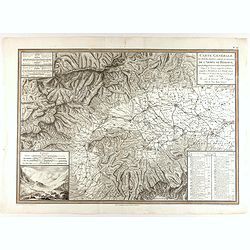
Carte générale des marches, positions, combats et batailles de l'Armée de réserve. . . (N°12)
Very detailed map centered on the Italian Alps showing the marches, positions, combats and battles of the famous Napoleon's crossing the Alps in the year 8 (1799) . In an...
- $750 / ≈ €649
Date: Paris, 1803
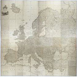
Carte de l'Europe dediée a Son Altesse royale Monseigneur Charles Louis archiduc d'Autriche, prince royal de Hongrie et de Bohéme, chevalier de la Toison d'Or, Grand-Croix de l'ordre...
Probably the largest published map of Europe during the regime of Napoleon.In upper left corner a large title cartouche with coats of arms and a dedication to Archduke Ch...
- $4000 / ≈ €3462
Date: Paris, 1803
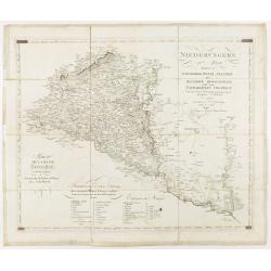
Niederungern Ivtes Blatt enthaltend die Schumegher, Tolner, Baranyer. . . Partie IVè de la basse hongrie contenant les comtes de Schumegh, de Tolna, de Baranya. . .
Map of Hungary. In the lower explicative key. Detailed map of the Southern part of Hungary with Kopreinitz until Lake Balaton, which is one of the most popular summer des...
Date: Kunst u. Industrie Compt., Vienna, 1803
Charte von China nach Murdochischer Projection entworfen. ... Berichtiget, und gezeichnet von H.F.A. Stieler. . .
Uncommon map of China prepared by H.F.A.Stieler, with parts of Taiwan, Tibet, Mongolia and the Korean peninsula, with a great many place names, a key to (and brief explan...
- $600 / ≈ €519
Date: Weimar, 1804
First Russian mission.
A rare Nagasaki-e print of the first Russian mission to Japan.
- $2250 / ≈ €1947
Date: Nagasaki, c.1804

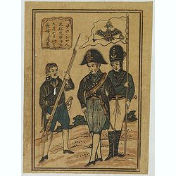
Two traders.
A rare Nagasaki-e print of the first Russian mission to Japan.
- $2250 / ≈ €1947
Date: Nagasaki, c.1804
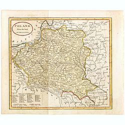
Poland from the best authorities.
Detailed map of Poland from "A New Geographical, Historical, and Commercial Grammar", by William Guthrie. William Guthrie (later engraver for Carey) London, UK....
Date: London, 1805
Die Götha-Elf. Nach Friedr. Akrel's Plancharta öfver Trollhättan reducirt.
Uncommon map prepared by Carl Frederik Akrell. Showing the River Gotha from Gothenburg till Vänersborg.Published by Geographisen Institut in Weimar. A scale in Swedish m...
- $100 / ≈ €87
Date: Weimar, 1805
Paysan & Paysanne d'Hanas en Boheme.
Originally hand-colored mezzotint from 'Costumes civils actuels de tous les peuples connus'. Engraved by Lachaussée Jeune after Jacques Grasset de Saint-Sauveur.As an et...
- $50 / ≈ €43
Date: Paris,1805
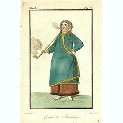
Homme & et Femme de la Sirie.
Originally hand-colored mezzotint from 'Costumes civils actuels de tous les peuples connus'. Engraved by Félix Mixelle after Jacques Grasset de Saint-Sauveur.As an etche...
- $50 / ≈ €43
Date: Paris,1805
Plan de la ville de Vienne et de ses faubourgs divisés en quartiers.
Fine plan of Vienna, engraved by Franz T. Müller and published by Jean Crappi. On both side an extensive key and a color key to the different sectors in town.
- $900 / ≈ €779
Date: Vienna, 1805
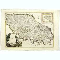
L'Isle de CORSE Divisée en ses departemens.
Nice map of Corsica, with a decorative cartouche in the left low corner. Small inset map of Sicily in the upper right corner: "Pointe de Capo Corso".This is the...
- $1750 / ≈ €1515
Date: Venise,1805
![[Title page Atlas Universel...]](/uploads/cache/47727-250x250.jpg)
[Title page Atlas Universel...]
Beautiful title-frontispiece from the famous universal atlas initiated by geographers Gilles Robert and his son Didier Robert de Vaugondy, revised, corrected and enhanced...
Date: Paris, 1805
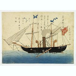
'Jokisen no zu' (Steamboat)
Nagasaki-e original Japanese woodblock print of a Steamboat. The figurehead is a striking detail.Nagasaki-e are Japanese woodblock prints that depict foreigners (Mostly ...
- $3750 / ≈ €3245
Date: Nagasaki, c.1805
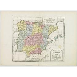
L'Espagne et le Portugal. Divisés Par Gdes. Provinces.
Map of Spain and Portugal, including the Balearic Islands archipelago. From Atlas de la Géographie de toutes les parties du monde .. Ouvrage destiné pour l'education, e...
- $80 / ≈ €69
Date: Paris, Prudhomme, Levrault, Debray, 1806
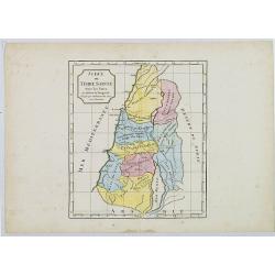
Judée ou Terre Sainte sous les Turcs.
Map of the Holy Land. By C. F. Delamarche, successor of Robert de Vaugondy, Geographer.
- $50 / ≈ €43
Date: Paris, ca.1806
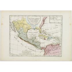
Nouvelle Espagne, Nouveau Méxique, Isles Antilles, par Robert de Vaugondy corrigés par le Cen. Lamarche Géog. Successeur de Vaugondy. l''An 3e.
Although dated 1794/95 [l'An 3e.], the map is a copy of an earlier map which appeared in Robert de Vaugondy's 1778 atlas. Hence, it does not show the newly independent Un...
- $300 / ≈ €260
Date: Paris, 1794 - 1806
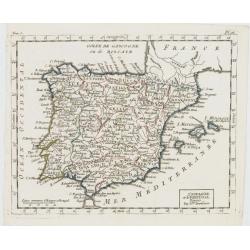
Royaumes d'Espagne et du Portugal.
Map of Spain and Portugal. By C. F. Delamarche, successor of Robert de Vaugondy, Geographer.
- $80 / ≈ €69
Date: Paris, 1794 - 1806
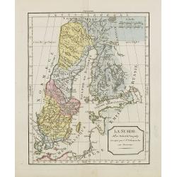
La Suède.
Map of Sweden and Finland. By C. F. Delamarche, successor of Robert de Vaugondy, Geographer.
Date: Paris, ca.1806
![[Butterflies]](/uploads/cache/25584-250x250.jpg)
[Butterflies]
Plate CXXIV from Carl Gustav Jablonsky and J.F.W. Herbst: "Natursystem aller bekannten in- und ausländischen Insecten", engraved by Bodenehr. Carl Gustav Jablo...
- $100 / ≈ €87
Date: Berlin, J. Pauli, 1785-1806
![[Butterflies]](/uploads/cache/25585-250x250.jpg)
[Butterflies]
Plate CLXXXIII from Carl Gustav Jablonsky and J.F.W. Herbst: "Natursystem aller bekannten in- und ausländischen Insecten", engraved by Bodenehr. Carl Gustav Ja...
- $100 / ≈ €87
Date: Berlin, J. Pauli, 1785-1806
![[Butterflies]](/uploads/cache/25586-250x250.jpg)
[Butterflies]
Plate CXCVIII from Carl Gustav Jablonsky and J.F.W. Herbst: "Natursystem aller bekannten in- und ausländischen Insecten", engraved by Bodenehr. Carl Gustav Jab...
- $100 / ≈ €87
Date: Berlin, J. Pauli, 1785-1806
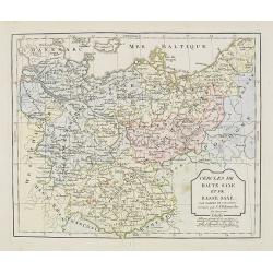
Cercle de Haute Saxe et de Basse Saxe. . .
Map of the duchies of Saxony (upper & lower). By C. F. Delamarche, successor of Robert de Vaugondy, Geographer.
- $50 / ≈ €43
Date: Paris, 1794 - 1806
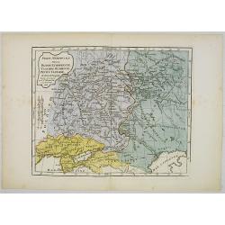
Partie Méridionale de la Russie Européenne, Tartarie, Russienne, Petite Tartarie.
Map of the southern part of Russia and Tartary. By C. F. Delamarche, successor of Robert de Vaugondy, Geographer.
- $90 / ≈ €78
Date: Paris, 1806
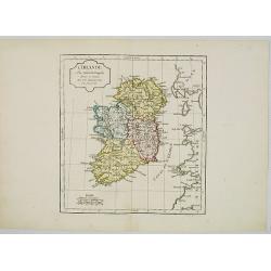
L' Irlande.
Map of Ireland. By C. F. Delamarche, successor of Robert de Vaugondy, Geographer.
- $90 / ≈ €78
Date: Paris, 1794 - 1806
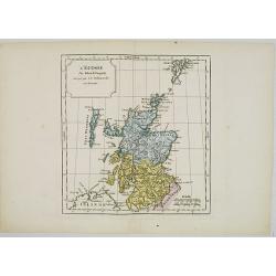
L' Ecosse.
Map of Scotland. By C. F. Delamarche, successor of Robert de Vaugondy, Geographer.
- $50 / ≈ €43
Date: Paris, 1794 - 1806
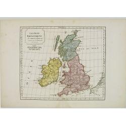
Les Isles Britanniques.
Map of British Isles. By C. F. Delamarche, successor of Robert de Vaugondy, Geographer.
- $80 / ≈ €69
Date: Paris, 1794 - 1806
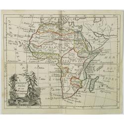
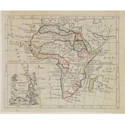
L'Afrique . . .
Map of the African continent, from Atlas moderne portatif composé de vingt-huit cartes sur toutes les parties du globe terrestre .. A l'usage des Colléges, des Pensions...
Date: Paris, Prudhomme, Levrault, Debray, 1806
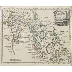
Les Indes Orientales et leur Archipel . . .
Map of India, the Maldive Islands, the Indonesian and Philippine Islands, from Atlas moderne portatif composé de vingt-huit cartes sur toutes les parties du globe terres...
- $300 / ≈ €260
Date: Paris, Prudhomme, Levrault, Debray, 1806
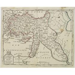
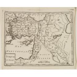
Turquie d'Asie . . .
Map of Turkey, including Cyprus, Palestine, etc. , from Atlas moderne portatif composé de vingt-huit cartes sur toutes les parties du globe terrestre .. A l'usage des Co...
- $100 / ≈ €87
Date: Paris, Prudhomme, Levrault, Debray, 1806
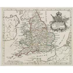
Carte du Royaume d' Angleterre . . .
Map of England and its counties, from Atlas moderne portatif composé de vingt-huit cartes sur toutes les parties du globe terrestre .. A l'usage des Colléges, des Pensi...
Date: Paris, Prudhomme, Levrault, Debray, 1806
L'Allemagne . . .
Map of Germany, from Atlas moderne portatif composé de vingt-huit cartes sur toutes les parties du globe terrestre .. A l'usage des Colléges, des Pensions & des Mai...
- $50 / ≈ €43
Date: Paris, Prudhomme, Levrault, Debray, 1806
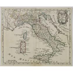
Carte d' Italie . . .
Map of Italy from Atlas moderne portatif composé de vingt-huit cartes sur toutes les parties du globe terrestre .. A l'usage des Colléges, des Pensions & des Maison...
Date: Paris, Prudhomme, Levrault, Debray, 1806
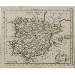
L' Espagne et le Portugal . . .
Map of Spain and Portugal, from Atlas moderne portatif composé de vingt-huit cartes sur toutes les parties du globe terrestre .. A l'usage des Colléges, des Pensions &a...
Date: Paris, Prudhomme, Levrault, Debray, 1806
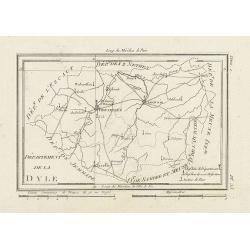
Département de la Dyle.
Map centered on Bruxelles with a short key list in the lower right corner. From Atlas de la Géographie de toutes les parties du monde .. Ouvrage destiné pour l'educatio...
- $40 / ≈ €35
Date: Paris, Prudhomme, Levrault, Debray, 1806
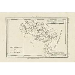
Département de Jemmape.
Map representing the area around Mons, with a short key list in the lower right corner.From Atlas de la Géographie de toutes les parties du monde .. Ouvrage destiné pou...
- $30 / ≈ €26
Date: Paris, Prudhomme, Levrault, Debray, 1806
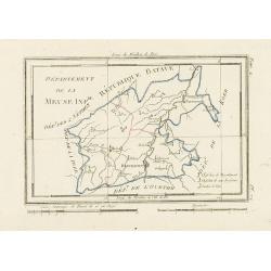
Département de la Meuse Inf.re.
Map representing the area around Maastricht, with a short key list in the lower right corner.From Atlas de la Géographie de toutes les parties du monde .. Ouvrage destin...
- $40 / ≈ €35
Date: Paris, Prudhomme, Levrault, Debray, 1806
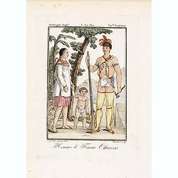
Homme & Femme Ottawas.
Hand-colored mezzotint of Native Americans engraved by Félix Mixelle and Lachaussée Jeune after Jacques Grasset de Saint-Sauveur.As an etcher, drawer and writer, Grasse...
- $75 / ≈ €65
Date: Paris,1801-1806
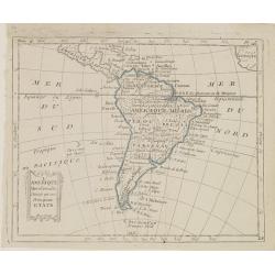
L'Amérique Méridionale, Divisée en ses Principaux Etats.
Map of South America, from Atlas de la Géographie de toutes les parties du monde .. Ouvrage destiné pour l'education, et nécessaire aux négocians, aux voyageurs, aux ...
Date: Paris, Prudhomme, Levrault, Debray, 1806
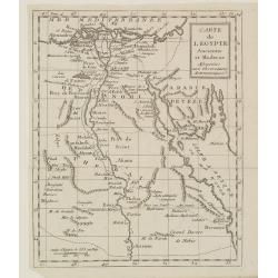
Carte de l'Egypte Ancienne et Moderne..
Map of Egypt illustrating part of the course of the river Nile. From Atlas de la Géographie de toutes les parties du monde .. Ouvrage destiné pour l'education, et néce...
Date: Paris, Prudhomme, Levrault, Debray, 1806
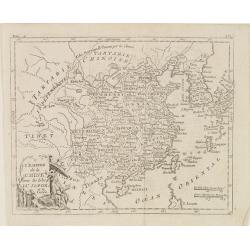
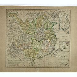
L'Empire de la Chine, avec les Isles du Japon, et la Corée.
Map of south eastern China, including Taiwan, Korea and Japan. From Atlas de la Géographie de toutes les parties du monde .. Ouvrage destiné pour l'education, et néces...
Date: Paris, Prudhomme, Levrault, Debray, 1806
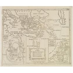
Carte des Régions et des Lieux dont il est parlé dans le Nouveau Testament.
Map of the eastern part of the Mediterranean with its hinterland. In the lower corners two inset maps: a plan of Jerusalem in the lower left, a map of Judea or Palestine ...
Date: Paris, Prudhomme, Levrault, Debray, 1806
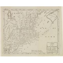
Carte de la Nouvelle Angleterre, Nouvelle York, Nouvelle Jersey, et Pensilvanie.
Map of the north eastern part of the United States, from Atlas de la Géographie de toutes les parties du monde .. Ouvrage destiné pour l'education, et nécessaire aux n...
Date: Paris, Prudhomme, Levrault, Debray, 1806
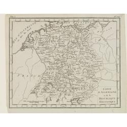
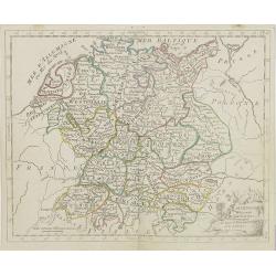
Carte d'Allemagne et de la Republique Helvetique.
Map of central Europe centered on Germany, extending southwards and eastwards to include Poland, the Czech Republic, Austria, Switzerland, Slovenia and part of Italy.From...
Date: Paris, Prudhomme, Levrault, Debray, 1806
Turquie d'Asie.
Map of Turkey, including Cyprus and part of the Near East. From Atlas de la Géographie de toutes les parties du monde.. Ouvrage destiné pour l'education, et nécessaire...
Date: Paris, Prudhomme, Levrault, Debray, 1806
L'Afrique Divisée en ses Principaux Etats.
Map of Africa, from Atlas de la Géographie de toutes les parties du monde.. Ouvrage destiné pour l'education, et nécessaire aux négocians, aux voyageurs, aux fonction...
Date: Paris, Prudhomme, Levrault, Debray, 1806
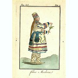
Femme Mordivine.
Originally hand-colored mezzotint of a Mordvinian woman from Ural region dressed in native garb, engraved by Félix Mixelle and Lachaussée Jeune after Jacques Grasset de...
Date: Paris,1801-1806
Femme de Barabinze.
Originally hand-colored mezzotint of a woman from Barabinze, engraved by Félix Mixelle and Lachaussée Jeune after Jacques Grasset de Saint-Sauveur.As an etcher, drawer ...
Date: Paris,1801-1806
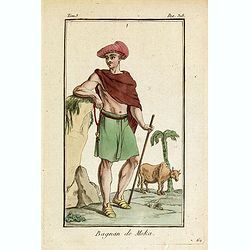
Bagnan de Moka.
Originally hand-colored mezzotint of a man in Banyan costume in Mocha, Yemen engraved by Félix Mixelle and Lachaussée Jeune after Jacques Grasset de Saint-Sauveur.As an...
- $25 / ≈ €22
Date: Paris,1801-1806
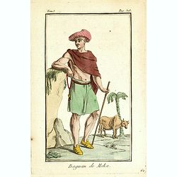
Bagnan de Moka.
Originally hand-colored mezzotint of a Banyan costume in Mocha, Yemen engraved by Félix Mixelle and Lachaussée Jeune after Jacques Grasset de Saint-Sauveur.As an etcher...
Date: Paris,1801-1806
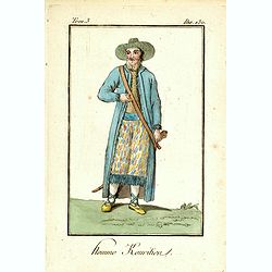
Homme Kouritien.
Originally hand-colored mezzotint of a Siberian man dressed in native garb, engraved by Félix Mixelle and Lachaussée Jeune after Jacques Grasset de Saint-Sauveur.As an ...
Date: Paris,1801-1806
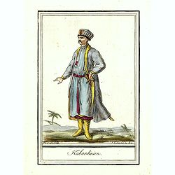
Kabardinien.
Originally hand-colored costume mezzotint of a Kabardian from the Northwest Caucasus, engraved by Félix Mixelle and Lachaussée Jeune after Jacques Grasset de Saint-Sauv...
Date: Paris,1801-1806