Browse Listings
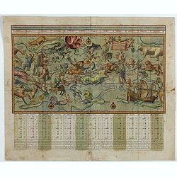
Sterre kaert of hemels pleyn, waer door men kan wete hoe laet dat het is over de gehele aertkloot, op alle meridiane en polus hoogte . . .
A most attractive Mercator style oblong projection of the entire night sky showing all the heavenly bodies of the northern and southern skies, and with panels of astrolog...
Date: Amsterdam, 1792
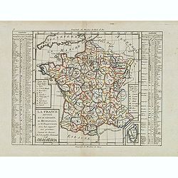
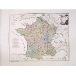
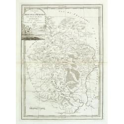
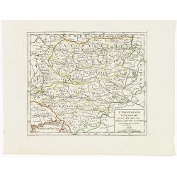
La France Divisée en IX Régions, 10 Métropoles, et 85 Départements ..
Scarce map of France prepared after J.B.Nolin and published by Mondhare for his Atlas Général a l'usage des colleges et maisons d'education.. Lower right inset map of C...
- $60 / ≈ €52
Date: Paris, 1793
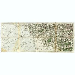
Les environs de Mons, Beaumont, Chimay, Valenciennes, Condé, &c.
Detailed map of Northern France, centered on Valenciennes and Mons. The map was prepared by Jean Baptiste de Bouge (1757-1833), who prepared one of the first very detaile...
- $50 / ≈ €43
Date: Bruxelles 1789 - 1793
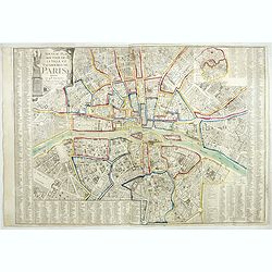
Nouveau plan routier de la ville de Paris.
Detailed plan of Paris. There is a street index down both margins and a list of theatres and public libraries. The plan now shows Place de la Révolution, Place des Pique...
- $1000 / ≈ €865
Date: Paris, 1793
![[Lot of 8 broad sheets] Campaign indemnities granted to pharmacy students in ambulant hospitals.](/uploads/cache/48381-250x250.jpg)
[Lot of 8 broad sheets] Campaign indemnities granted to pharmacy students in ambulant hospitals.
Eight campaign indemnities granted to pharmacy students in ambulant hospitals during the French Revolution and the Wars of Vendée. L’Armée des Côtes de La Rochelle (...
- $400 / ≈ €346
Date: Niort, 1793

A chart of the northern part of the Indian Ocean..
Chart of the northern part of the Indian Ocean, including part of Arabia, India and Sri Lanka prepared by D'Apré de Mannevillette and published in London by Laurie and W...
- $750 / ≈ €649
Date: London 1794
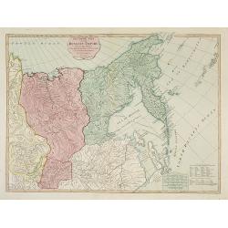
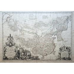
The Asiatic Part of the Russian Empire. . .
Large map of Asiatic Russia and some of the Aleutians recently discovered. Many details and speculations. Features the important discoveries of Vitus Behring (or Bering),...
- $500 / ≈ €433
Date: London, 1794
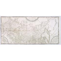
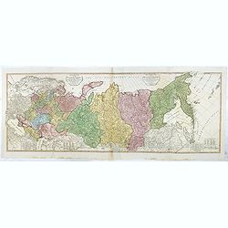
Carte générale de l'empire de Russie.
Map of Russia. Map from a second French edition of Peter Simon Pallas' Voyages du Professeur Pallas, dans Plusieurs Provinces de l’Empire de Russie et dans l’Asie Sep...
Date: Paris, Maradan, 1794
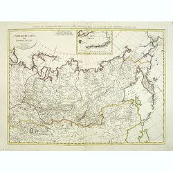
Imperii Russici Pars Orientem Spectans Tab. II da. ex optimis subsidiis delineata a. C. Mannert Norimberge Prostat in Officina A. G. Schneideriana. . .
The Russian empire eastward from the Dvina River, indicating some unexplored coastlines in Nova Zemlya and northeastern Siberia. Includes an inset with a portion of Alask...
Date: Nurernberg, 1794
![Boertige reis door Europa. . . [with] Europa volgens de nieuwste verdeeling. . .](/uploads/cache/32642-250x250.jpg)
Boertige reis door Europa. . . [with] Europa volgens de nieuwste verdeeling. . .
Rare illustrated publication including a rare map of Europe as a regal queen with the title "Geheimzinnige toebereidselen tot eene boertige reis door Europa. [...] v...
- $2000 / ≈ €1731
Date: Haarlem, 1794
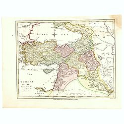
Turkey in Asia.
An attractive map covering Asia Minor, Syria, Armenia, Georgia, Kurdistan, Iraq, Syria, Cyprus and the Black Sea. Shows towns, rivers, mountains, lakes, etc. In pretty or...
- $65 / ≈ €56
Date: London, 1794
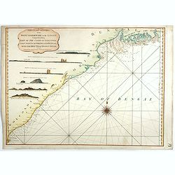
The Coast of India, from Point Gordeware to the Ganges Comprehending Part of the Coast of Golconda . . .
Detailed sea chart of the coast of India, from the mouths of the Ganges Rivers in the northeast to Point Gordeware in the south west. Includes numerous sailing channels a...
- $400 / ≈ €346
Date: London, 1794
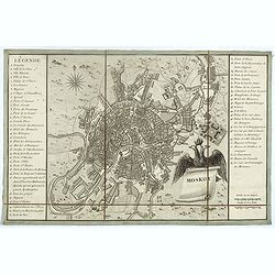
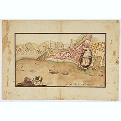
Moskou.
Charming little town-plan of Moscow engraved by Tardieu. Separately issued and also included in "l’Histoire de la Russie" by Leclerc. This plan is decorated w...
- $750 / ≈ €649
Date: Paris, 1794
The European Part of the Russian Empire . . .
Highly detailed map of the Russian Empire at the end of the 18th Century, by William Faden.The map is a significant advance from the earlier maps by Kitchin, Sayer and Je...
- $800 / ≈ €692
Date: London, 1794

Cecilia - Cecile.
Painted by Tho. Stothard and engraved by Masetti.
Date: London, 1794
Karte von Frankreich.
An attractive oversized map of France. With a decorative title cartouche in the upper right-hand corner and a legend on the left side. Engraved by Ant.Amon.Franz Johann J...
Date: Vienna, 1795
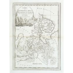
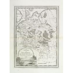
I Governi Di Moscovia E Woronez Nell' Impero Della Russia In Europa . . .
Rare and highly decorative regional map of Russia. The map is centered on Moscow and covers the region bounded by the course of the Volga River from north of Romanow to t...
- $350 / ≈ €303
Date: Rome, 1795
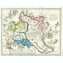
Carte générale de la Pologne : avec ses différens démembremence par les puissances partageantes en 1773 et 1795 / dessinée et dressée par Mariaval. . .
Very rare map of Poland, engraved by Tardieu l’Ainé, active at rue de Sorbonne 385.
Date: Paris, ca. 1795
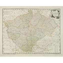
Karte von dem Konigreiche Boheim.
An attractive map of Bohemia. With a nice title cartouche decorated with cherubs in the upper right-hand corner. Engraved by Kil. Ponheimer.Franz Johann Josef von Reilly ...
- $300 / ≈ €260
Date: Vienna, 1796
I Governi di Olonechoi, Carella, Bielozero, e'd Ingria nell Impero della Russia in Europa con la Lapponia Russa. . .
An uncommon map of Finland, Lapland and part of Russia with highly decorative title cartouche. From 'Nuovo Atlante Geografico Universale'.
Date: Rome, 1796
Il governo di arcangelo nell' impero della russia diviso. . .
Detailed map of the northern part of the Russian Empire with a decorative title cartouche. In the upper left corner part of the Baltic Sea with Lapland. Published in the ...
Date: Rome, 1795-1796
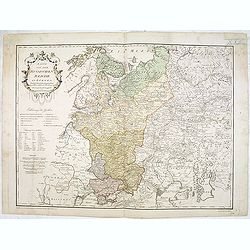
Karte von dem Russischen Reiche in Europa . . .
An attractive map of European Russia. Very detailed with rivers lakes mountains etc. Russia with a decorative title cartouche in the upper left-hand corner. Engraved by F...
- $650 / ≈ €563
Date: Vienna, 1796
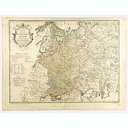
Karte von dem Russischen Reiche in Europa . . .
An attractive large map of European Russia, including Finland. Very detailed with rivers lakes mountains etc. Russia with a decorative title cartouche in the upper left-h...
- $650 / ≈ €563
Date: Vienna, 1796
Le Royaume De Pologne, divise selon les Partages faits en 1772, 1793 et 1795, etnre la Russie, la Prusse et l'Autriche . . .
The uncommon later edition of this detailed map of Poland, showing the lands lost to Russia, Prussia and Austria in 1772, 1793 and 1795. with a color key added underneath...
Date: Paris, ca. 1796
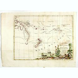
Nuova Guinea e Nuova Galles ed Isole Adjacenti
Map of the South Pacific, showing the sailing routes to the South Pacific by Carteret and Byron, but most importantly the discoveries made by Captain Cook, 1768-1771. The...
- $1750 / ≈ €1515
Date: Venise, 1794-1796
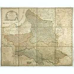
Karte von Polen.
An attractive map of Poland. With a decorative title cartouche in the upper left-hand corner. Engraved by Ant. Amon. Franz Johann Josef von Reilly (Vienna 18 august 1766 ...
- $950 / ≈ €822
Date: Vienna, 1796
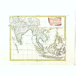
Le Indie Orientali E Il Loro Arcipelago . . .
Striking map of the region from the Gulf of Bengal to Hainan, centered on the Malay Peninsula, Straits of Malacca, Sumatra, Java and Philippines.This is the uncommon edit...
- $500 / ≈ €433
Date: Venise, 1794-1796
Sketch of A Journey from Hang-Tchoo-Foo To Quang-Tchoo-Foo or Canton in China.
A detailed map taken from, from Staunton's 'An Authentic Account of an Embassy from the King of Great Britain to the Emperor of China'.The map shows the second part of Ma...
Date: London, 1796
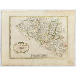
I Paési Bassi Austriaci.
A rare and detailed map of Belgium by Pazzini, Carli (1707-1769) and Bartolomeo Borghi (1750-1821). Features decorative title cartouche. Included in "Atlante Geogra...
- $125 / ≈ €108
Date: Siena, 1796
![Mappa Mondo tagliato sulpiano di unmeridiano Emisfero Occidentale. [togther with] … Orientale.](/uploads/cache/48543-250x250.jpg)
Mappa Mondo tagliato sulpiano di unmeridiano Emisfero Occidentale. [togther with] … Orientale.
World map on two sheets - Western Hemisphere (North and South America, Oceania, Greenland) and Eastern Hemisphere (Europe, Africa, Asia, Australia). Published by Pazzini,...
- $500 / ≈ €433
Date: Siena, 1796
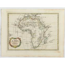
L'Africa divisa nelle sue principali parti…
Rare map of Africa. Published by Pazzini, Carli (1707-1769) and prepared by Bartolomeo Borghi (1750-1821). Features decorative title cartouche. Included in "Atlante ...
- $300 / ≈ €260
Date: Siena, 1796
![[Lot of 3 maps] Le Coste Dell' Alta Guinea… [with] Carta del Basso Egitto [with] Le Coste di Barbaria.](/uploads/cache/48545-250x250.jpg)
[Lot of 3 maps] Le Coste Dell' Alta Guinea… [with] Carta del Basso Egitto [with] Le Coste di Barbaria.
A lot of three maps of nort and eastern Africa. Published by Pazzini, Carli (1707-1769) and prepared by Bartolomeo Borghi (1750-1821). Features decorative title cartouche...
- $300 / ≈ €260
Date: Siena, 1796
![[Lot of 2 maps] Important plan of Port Bucarelli 1384 / Chart of the entrance of "Bassin de L'Quest", La Perouse. 1709](/uploads/cache/20473-250x250.jpg)
[Lot of 2 maps] Important plan of Port Bucarelli 1384 / Chart of the entrance of "Bassin de L'Quest", La Perouse. 1709
Chart of the entrance of "Bassin de L'Quest", La Perouse. 1709 / With antique print of Alaska] Pirogue du port des Francais. / Pirogue, trouvee au port des Fran...
- $350 / ≈ €303
Date: Paris, 1797
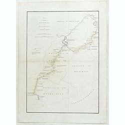
Plan de la partie des iles, ou archipel de Coree, vue au mois de Mai 1787 par les Fregates Francaises la Boussole et l'Astrolabe. . . .
Showing the track of La Pérouse along the southern most tip of Korea, with Quelpaerts Islands (now-a-days called Jeju, with the vulcano Halla-san (Halla Mountain) clearl...
- $400 / ≈ €346
Date: L'Imprimerie de la Republique, An V, 1797
(Untitled map of northern Italy)
Including the towns of Milan, Bergamo, Mantova, Verona with the river Po in the bottom. One page from his multi sheet map "Carta del Territorio della Repubblica Casa...
- $250 / ≈ €216
Date: Florence, 1797
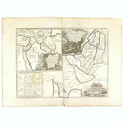
Terre de Chanaan, ou Terre promise à Abraham et à sa Posterité . . . .
Two maps on one sheet. With a map of Palestine and a map of the Near Eas with a title cartouche "Carte des voiages d'Abraham faits par l'ordre de Dieu, en Asie et en...
Date: Paris, ca. 1797
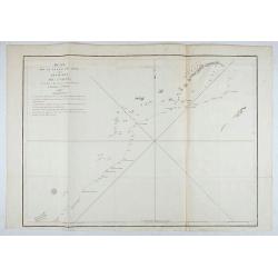
Plan de la partie des iles, ou archipel de Coree, vue au mois de Mai 1787 par les Fregates Francaises la Boussole et l'Astrolabe. . . .
Showing the track of La Perouse along the southernmost tip of Korea, with Quelpaerts Islands (nowadays called Jeju, with the volcano Halla-san (Halla Mountain) clearly no...
- $450 / ≈ €389
Date: L'Imprimerie de la Republique, An V, 1797
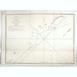
Plan de la partie des Isles ou Archipel de Corée.
Showing the track of La Perouse along the southern most tip of Korea, with Quelpaerts Islands (now-a-days called Jeju, with the volcano Halla-san (Halla Mountain) clearly...
Date: Paris, 1797
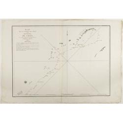
Plan de la partie des Isles ou Archipel de Coree.
Showing the track of La Perouse along the southernmost tip of Korea, with Quelpaerts Islands (nowadays called Jeju, with the vulcano Halla-san (Halla Mountain) is clearly...
Date: Paris, 1797
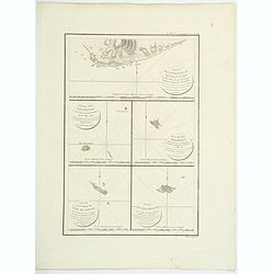
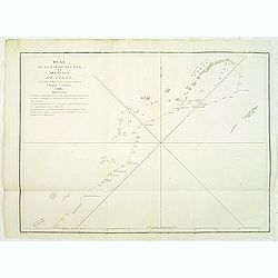
Plan de la partie de l'ile de quelpaert. . . / Plan de l'ile Hoapinsu. . . / Plan de l'ile Dagelet. . . / Plan de la partie de l'ile de Botol. . . / Plan de l'ile de Kumi. . .
Five plans on a folio sheet. These charts include Cheju Do, Korea (Quelpaert Is.), Kume-Shiwa, Okinawa (Kumi), and Ullung Do (Dagelet).Including one of the earliest maps ...
Date: Paris, 1797
Piano di Nizza.
Rare 1797 manuscript map of Nice, with the French navy attacking from the sea. Unknown author, Italian, but map attributed to an original, probably broadsheet map by Moll...
Date: Italy, after 1797
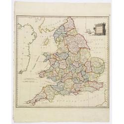
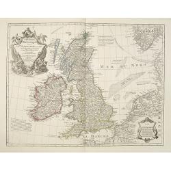
Present Britain.
A fully colored map of England and Wales from An Universal Atlas Consisting of a Complete Set of Maps, peculiarly adapted to illustrate and explain ancient and modern geo...
Date: London, 1797
![Part of the island of Quelpart seen 21 may 1787. . . [5 maps on one sheet]](/uploads/cache/29902-250x250.jpg)
Part of the island of Quelpart seen 21 may 1787. . . [5 maps on one sheet]
Detailed maps of islands south of Korea. Of interest is the inset map of L'ile Dagelet (The Isle of Dagelet), the note in French says "Discovered by the French friga...
- $300 / ≈ €260
Date: London, G. G. & J. Robinson, Paternoster Row, London, 1798
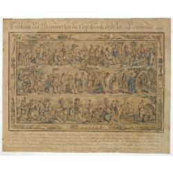
Tableau des Decouvertes du Cap.ne Cook, & de la Pérouse.
Three series of figures of natives with key below, surrounded by narrow pictorial border.Grasset de Saint Sauveur skillfully wove together two dozen individual scenes fro...
- $2200 / ≈ €1904
Date: Paris, 1798
Carte des découvertes au Nord du Japon.
Chart of the discoveries to the north of Japan, in 1643 by the Dutch ships Castricum and Breskens. In two small insets in the top of the chart the province of Osju is dep...
- $400 / ≈ €346
Date: Paris, 1798
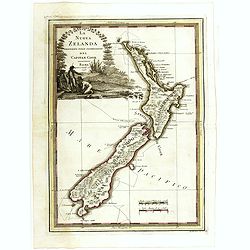
La nuova Zelanda delineate sulle ultima osservazioni del Capitan Cook.
First edition on laid paper Cassini’s splendid early map of New Zealand, being the most decorative version of Captain Cook's map of New Zealand, published in the very s...
Date: Rome, 1798
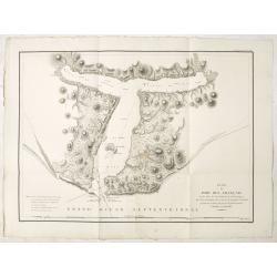
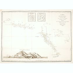
Plan du Port des Francais sur la Cote du Nord-Ouest de l'Amerique, par 58°37' de Latitude Nord et 139°50' de Longitude Occidentale, Decouverte le 2 Juillet 1786, par les Fregates Francaise la Boussole et l'Astrolabe.
Chart of the entrance of Bassin de L'Quest , visited on July 2nd 1786 by La Perouse. On many 18th century maps we find a depiction of Mer de L'Quest or Sea of the West a ...
- $500 / ≈ €433
Date: Paris, 1798
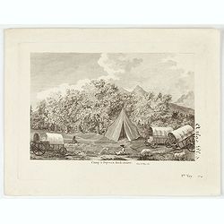
Camp à Duywen Hock Riviere. (Tom.1er. Pag.131.)
Camp Duywen Hock River engraved view, from Francois Levaillant’s Voyage dans l’interieur de l’Afrique. Text in French reads “Tom. 1er. Pag. 131. Atlas pl. 5. 1er ...
- $250 / ≈ €216
Date: Paris, 1798
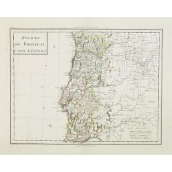
Royaume de Portugal Carte Générale.
Map of Portugal in attractive out-line color.
- $100 / ≈ €87
Date: Paris, 1799
A New Map of the Kingdom of Prussia with its Divisions Into Provinces and Governments . . .
Highly detailed regional map of Prussia, including the Baltic regions and part of Poland, from Cary's Universal Atlas, one of the finest atlases of the period.
- $275 / ≈ €238
Date: London, 1799
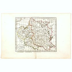
La Pologne avec le dernier partage.
Uncommon map of Poland and Lithuania. Engraved by Alexandre Blondeau (1799-1828), with Brezesci in the center of the map.From "Atlas universal pour la géographie de...
- $200 / ≈ €173
Date: Paris, Hyacinthe Langlois, 1799
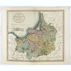
Empire d'Allemagne divisé par Cercles et Cours du Rhin.
Small detailed map of Germany, the Low Countries, Switzerland, Austria, Czechoslovakia and part of Poland.From Atlas Portatif Universel, by Robert de Vaugondy. Edited by ...
- $40 / ≈ €35
Date: Paris, 1799
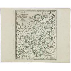
Cercle de Westphalie, divisé suivant ses différentes Principautés.
Small detailed map of the north western part of Germany, centred on Münster. From Atlas Portatif Universel, by Robert de Vaugondy.Edited by : "Au dépôt de Géogra...
- $30 / ≈ €26
Date: Paris, 1799
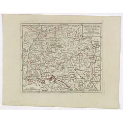
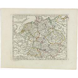
Cercle de Souabe où sont distingués les Enclaves de la Maison d'Autriche.
Small detailed map showing the state Baden-Württemberg, part of Bavaria and part of Austria.From Atlas Portatif Universel, by Robert de Vaugondy. Edited by : "Au d�...
- $70 / ≈ €61
Date: Paris, 1799
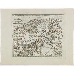
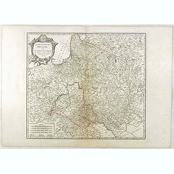
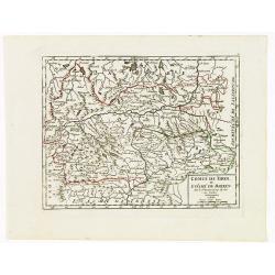
VII. Cours du Rhin où sont les environs de Philisbourg, Spire Landaw &c.
Small detailed map illustrating the stretch of the Rhine which flows between Germersheim and Speyer.From Atlas Portatif Universel, by Robert de Vaugondy. Edited by : &quo...
- $25 / ≈ €22
Date: Paris, 1799

Alexandre Mackenzie.
Copper engraving portrait of Alexander Mackenzie, engraved by Adam after a design of Sir Thomas Lawrence (1769–1830).Mackenzie was born in Stornoway, Scotland, in 1764....
- $200 / ≈ €173
Date: London, ca. 1799
L'Asie divisée dan ses principaux états, empires, et royaumes dréssée et augmentée des plus exactes nouvelles découvertes qui ont fait en plusieurs fois les plus celebres capitaines.
A very rare map of Asia, in the style of Antonio Zatta with a scenic title cartouche, but folio-sized. It comes from a never-finished atlas by the ‘Società Calcografia...
Date: Venise, 1799
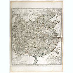
Carte Generale de la Chine Dressée sur les Cartes Particulieres Que l' Empereur Chang-Hi a fait lever sur les lieux. . . .
With a quite elaborately pictorial cartouche, engraved by the master engraver Guillaume-Nicolas de la Haye (1727 -1802). Large map showing the traditional limits of China...
- $750 / ≈ €649
Date: Paris, Dezauche, 1789–1799
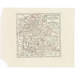
Comté de Tirol, et Evêché de Brixen.
Small detailed map of Tirol and the Italian Alto-Adige region, centered on Innsbruck. From Atlas Portatif Universel, by Robert de Vaugondy.Edited by : "Au dépôt de...
Date: Paris, 1799
Cercle des quatre Electeurs.
Small detailed map of part of western Germany, centered on Frankfurt. From Atlas Portatif Universel, by Robert de Vaugondy.Edited by : "Au dépôt de Géographie, Ru...
Date: Paris, 1799
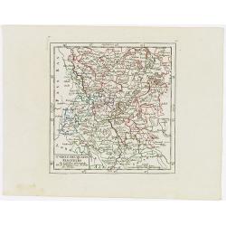
Cercle de Baviere où se trouvent le Palatinat de Baviere et l'Archev. De Saltzbourg.
Small detailed map of the southeastern part of Bavaria, including part of Austria. From Atlas Portatif Universel, by Robert de Vaugondy.Edited by : "Au dépôt de G�...
Date: Paris, 1799
L'Archiduché d' Autriche et les Duchés de Stirie, Carinthie et Carniole.
Small detailed map of the eastern part of Austria, including Slovenia and part of Italy.From Atlas Portatif Universel, by Robert de Vaugondy. Edited by : "Au dépôt...
Date: Paris, 1799
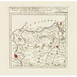
I. Carte du Comté du Haynaut.. Tournay.
Attractive small map encompassing part of Hainaut, between Tournai and Ath. From Atlas Portatif Universel, by Robert de Vaugondy.Edited by : "Au dépôt de Géograph...
Date: Paris, 1799
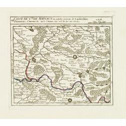
VIII. Carte du C.té de Haynaut où sont les environs de Landrechies..
Attractive small map showing an area straddling the regions Picardy and Nord. It shows the towns of La Capelle, Landrecies and Avesnes-sur-Helpe.From Atlas Portatif Unive...
Date: Paris, 1799
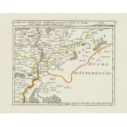
X. Carte du Comté de Namur où se trouvent les environs de Dinant.
Attractive small map showing an area straddling the border between France and Belgium.It shows Dinant, Ciney, and the fort of Charlemont, built by Charles V on the French...
Date: Paris, 1799
Carte la plus generale et qui comprend la Chine, la Tartarie chinoise et le Thibet. . .
With a quite elaborately pictorial cartouche, engraved by G.Kondet. Very detailed map of China, Tibet and Korea. Jean Baptiste Bourguignon d' Anville (1697-1782), French ...
- $2700 / ≈ €2337
Date: Paris, Dezauche, 1789–1799

Vue du sperbe Temple de St.Sophie .. a Constantinople.
A fanciful depiction of the Aya Sofya in Istanbul. In the eighteenth and nineteenth centuries there were many popular speciality establishments in Paris, Augsburg and Lon...
Date: Paris, 1800

No title: training a horse.
After a design by Silva.
- $75 / ≈ €65
Date: Italy, c. 1800
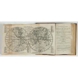
A new and easy introduction to universal geography: In a series of letters to a youth at school. . . The ninth edition, improved and considerably enlarged.
This is the interesting ninth edition, with 26 full-page maps as called for in "Directions to the binder". The ninth edition was improved and considerably enlar...
Date: London, 1800
Les Isles Britanniques ou sont le Rme. D'Angleterre . . . Par G. De L'Isle. . . A Paris Chez Dezauche. . .
Uncommon late edition, (dated An 8, 1800 ) of this map of the British Isles prepared by DeL'Isle and published during the French Revolution by Dezauche / Buache. The bott...
Date: Paris, 1800
Dutch landscape.
Finely executed water color in pen and ink and gray wash color. Showing a Dutch landscape with farm house and windmills on the horizon.
- $60 / ≈ €52
Date: Probably The Netherlands, ca. 1800
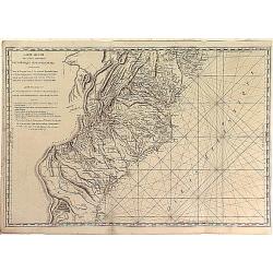
Carte Réduite des Côtes Orientales Del'Amérique Septentrionale Contenant partie du Nouveau Jersey, la Pen-sylvanie, le Mary-land, la Virginie, la Caroline Septentrionale, la Caroline Méridionale et la Georgie. . .
Scarce Rome edition of an French map made expressly for use of the French Navy during the American Revolution. Covering the area of Maryland, North and South Virginia. Ph...
- $900 / ≈ €779
Date: Genova, Yves Gravier, c.1800
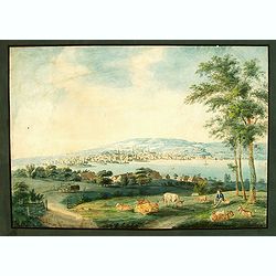
Vue de Zurich.
Good sized panoramic view of Zürich in the style of BLEULER with the foreground a resting shepherd with his sheep's under a tree. The engraving/etching is hand colored a...
- $900 / ≈ €779
Date: Ca. 1800
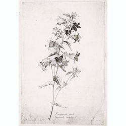
Campanule gantelée. - Campanule trachaelium L.
Bouquet of poppy flowers, engraved by P.F. Le Grand after designs by the Dutch born Gerard van Spaendonck (1746-1822).Taken from the rare work "Fleurs dessinées d'a...
Date: Paris, c.1800
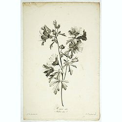
Mauve alcée. Malva alcea L.
Greater musk-mallow, stipple engraving by P.F. Le Grand after designs by the Dutch born Gerard van Spaendonck (1746-1822).Taken from the rare work "Fleurs dessinées...
Date: Paris, c.1800

Seringat odorant - Philadelphus coronarius L.
Sweet Mock-Orange, English Dogwood engraving by P.F. Le Grand after designs by the Dutch born Gerard van Spaendonck (1746-1822).Taken from the rare work "Fleurs dess...
Date: Paris, c.1800

Souci des Jardins. Calendula Officinalis. L.
The Common Marigold, engraving by P.F. Le Grand after designs by the Dutch born Gerard van Spaendonck (1746-1822).Taken from the rare work "Fleurs dessinées d'aprè...
Date: Paris, c.1800
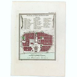
Plan de la ville de Pondicheri.
The first detailed French plan of Pondicherry. In the lower part, a lettered and numbered key and the coat of arms of Mr. Joseph-François Dupleix.The Compagnie des Indes...
- $120 / ≈ €104
Date: Paris, 1800
![Die Obere oder Nordliche Halbkugel der Erde auf den Horizont von Wien, Sterographisch Entworfen ... [together with] Die Untere oder Sudliche Halbkugel der Erde auf den Horizont von Wien, Stereographisch ...](/uploads/cache/39377-250x250.jpg)
Die Obere oder Nordliche Halbkugel der Erde auf den Horizont von Wien, Sterographisch Entworfen ... [together with] Die Untere oder Sudliche Halbkugel der Erde auf den Horizont von Wien, Stereographisch ...
A set of two uncommon large format maps of the Northern and Southern Hemisphere, based upon the work of Johann Anton Ecker (1755-1820). First published in 1794, this is t...
- $2000 / ≈ €1731
Date: Vienna, Phil. Jos Schalbacher, 1800
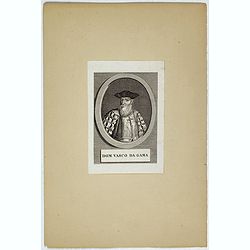
Dom Vasco Da Gama.
Portrait of Dom Vasco da Gama (c.1460 - 1524) , was a Portuguese explorer. He became famous for being the first European explorer to leave Europe by ship and sail to Indi...
- $80 / ≈ €69
Date: c. 1800