Browse Listings
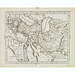
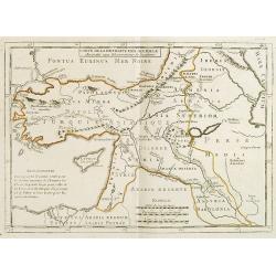
Alexandri magni imperium et expeditio per Africam. . .
Scarce map of the Imperium of Alexander the Great, centered on Turkey, Armenia, Uzbekistan, etc., prepared by Nolin and published by L.J. Mondhare for his Atlas Généra...
Date: Paris, 1781
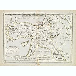
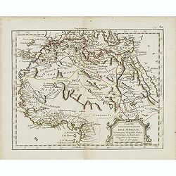
Carte de la retraite des dix mille. . .
Ancient map of Near and Middle East, including Cyprus, prepared by Nolin and published by L.J. Mondhare for his Atlas Général a l'usage des colleges et maisons d'educat...
- $50 / ≈ €43
Date: Paris, 1781
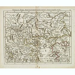
Graeciae pars septentrionalis. . .
Rare map of northern part of Greece and part of Turkey, prepared by Nolin and published by L.J. Mondhare for his Atlas Général a l'usage des colleges et maisons d'educa...
- $80 / ≈ €69
Date: Paris, 1781
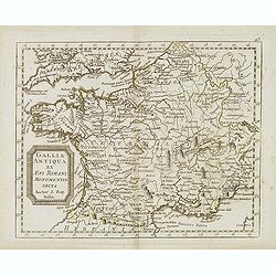
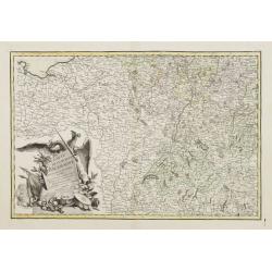
Gallia antiqua ex Aevi Romani monumentis eruta. . .
Historical map of France depicted in Roman times showing ancient divisions, prepared by Nolin and published by L.J. Mondhare for his Atlas Général a l'usage des college...
- $40 / ≈ €35
Date: Paris, 1781
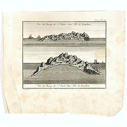
Vue du Bourg de St Denis dans l'Isle Bourbon. (together wit) Vue du Bourg de St.Paul dans l'Ile de Bourbon.
Two views from L'île de la Réunion on one plate. The upper part showing the town and harbour of St. Denis. From "Lettres Édifiantes et Curieuses. . Missionaires d...
- $45 / ≈ €39
Date: Lyon, J. Vernarel and Et. Cabin et C., 1780/1781
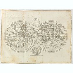
The world, including the discoveries made by Capt. Cook.
Uncommon double-hemisphere world map depicting the voyages and discoveries of Captain James Cook. There are numerous notations throughout and the tracks of Cook's three v...
- $1000 / ≈ €865
Date: London, 1781

Jacques Cook, Né à Marton dans la province d'York. . .
Steel engraved portrait of James Cook (1728-1779), navigator, born on 27 October 1728 at Marton-in-Cleveland, Yorkshire, England, the son of a Scottish labourer and his Y...
- $200 / ≈ €173
Date: 1781
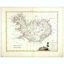
L'Isola d'Islanda divisa Ne Suoi Distretti Di nuova Projezione.
A finely engraved map of Iceland, with a decorative title cartouche to the bottom right hand corner illustrating a rural scene. Published in Zatta's "Atlante Novissi...
- $500 / ≈ €433
Date: Venise, 1781
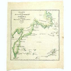
Karte welche die Russischen Entdeckungen gegen Amerika nach den Tagebüchern Krenizins, Lewaschefs, Synds und anderer vorstellt. 1781
Rare map of Siberia with Kamchatka. In outer right tip of America, published by the Weygandsche Buchhandlung in 1781.
- $300 / ≈ €260
Date: Leipzig, 1781
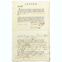
ACTION N°1160. Société du Commerce d'Asie & d'Afrique.
Share of 1 000 Florins d'Allemagne (1 000 Guilder) of the "Triester Handelsgesellschaft" (Société du Commerce d'Asie & d'Afrique) signed by duke Charles d...
Date: Antwerpen, 1 October 1781
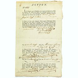
ACTION N°1527. Société du Commerce d'Asie & d'Afrique.
Share of 1 000 Florins d'Allemagne (1 000 Guilder) of the "Triester Handelsgesellschaft" (Société du Commerce d'Asie & d'Afrique) signed by Duke Charles d...
Date: Antwerpen, 1 October 1781
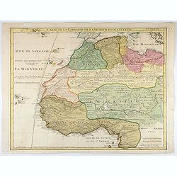
Carte de La Barbarie de La Nigritie et de la Guinée.
A detailed engraved map of north west Africa including the Canary and Cape Verde Islands. Engraved by Inselin. Address and date changed, now with the imprint "A Pari...
Date: Paris, 1781
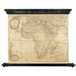
Carte D'Afrique Dressée pour l'usage du Roy. Par Guillaume Delisle, Premier Géographe de Sa Majesté, de l'Académie Royale des Sciences…
Curious late issue of De L'Isle's map of the African continent from 1722 map "Corrigée et Augmentée en 1781". - The decorative map shows the continent Africa ...
- $1250 / ≈ €1082
Date: Paris, 1781
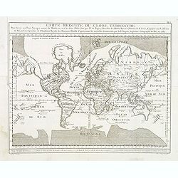
Carte Reduite du globe Terrestre. . .
Fine world map in a Mercator projection. From Voyages autour du monde et vers les deux pôles par terre et par mer.. by Pierre Marie François vicomte de Pages (1748-1793...
Date: Paris, ca 1782
Governo di Arcangelo, e sue Provincie Nella Russia Europea . . .
Map shows the island Nova Zembla and the government of Archangel, Jarensk and Chlynow. Engraved by G. Zuliani and G. Pitteri.Published in Zatta's "Atlante Novissimo&...
- $375 / ≈ €325
Date: Venice, 1782
La Lapponia Russa con Governi di Olonechoi, Carelia, Bielozero, ed Ingria. . .
An attractive and detailed map of Western Russia with Lapland and Finland, including the towns of St. Petersburg, Kola, and Helsinki. Decorative and large pictorial carto...
- $375 / ≈ €325
Date: Venice, 1782
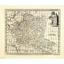
Poland Lithuania and Prussia.
Uncommon miniature map of Poland, Lithuania and the Ukraine, engraved by Thomas Kitchin - with his signature in lower right bottom.
Date: London, 1782
Ducati di Livonia e di Estonia, e Governi di Nowogorod...
Shows today's Estonia, and the governorates Nowgorod, Bialgorod and Kiew in today's Russia, Belarus and Ukraine.
- $175 / ≈ €151
Date: Venise, 1782
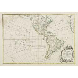
L'Amerique Septentrionale Divisee en Ses Principaux Etats. . .
Engraved by Lattré. This map is most notable for its depiction of Mer de L'Quest or Sea of the West, near modern-day Seattle. A great sea, easily the size of the Mediter...
- $400 / ≈ €346
Date: Paris, 1782

Mandarin accompagne de ses Bourreaux.
A copperplate taken from volume 2 of the work by Sonnerat titled: 'Voyage aux Indies Orientales et a Chine, fait par ordre du Roi, depuis 1774-1781…'.This colored coppe...
- $125 / ≈ €108
Date: Paris, ca. 1782
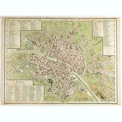
Paris Superficie 5,280,000 Toises.
FIRST EDITION of this finely engraved plan of Paris by P. F. Tardieu and prepared by DuBuisson. This detailed plan of Paris includes la Place Louis XV, la Bastille, but d...
- $600 / ≈ €519
Date: Paris, 1779-1782
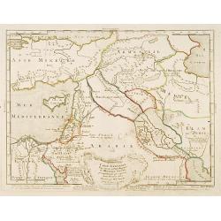
Carte générale pour servir à l'Intelligence de..
Fine map of the Middle East, including the Holy Land, Cyprus, Iran and Irak, etc.Philippe Buache was one of the most active proponents of the so-called, "school of t...
- $300 / ≈ €260
Date: Paris, 1783
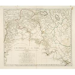
L'Euphrate et Le Tigre.
A detailed map prepared by D'Anville. Covering the Syrian Desert, Lebanon, and the mouth of the Tigris in the Persian Gulf. Including Babylon, Tripoli, etc.
- $150 / ≈ €130
Date: Nuremberg, 1783
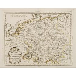
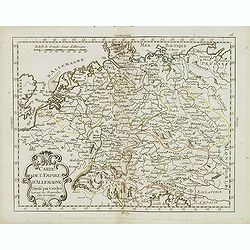
Carte de l'Empire d'Allemagne Divisé par Cercles..
Rare map of Germany and the Low Countries prepared by J.B.Nolin and published by Monhare for his Atlas Général a l'usage des colleges et maisons d'education.Louis Josep...
- $100 / ≈ €87
Date: Paris, 1783
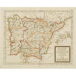
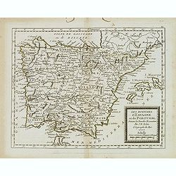
Les Royaumes d'Espagne et de Portugal ..
Rare map of Spain and Portugal prepared by J.B.Nolin and published by Monhare for his Atlas Général a l'usage des colleges et maisons d'education.. Louis Joseph Mondhar...
Date: Paris, 1783
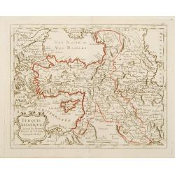
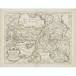
Turquie Asiatique Suivant des derniers Mémoires de J.B.Nolin Géographe du Roi.
Rare map of Turkey, prepared by J.B.Nolin and published by Monhare for his Atlas Général a l'usage des colleges et maisons d'education.Louis Joseph Mondhare published s...
- $125 / ≈ €108
Date: Paris, 1783
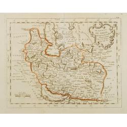
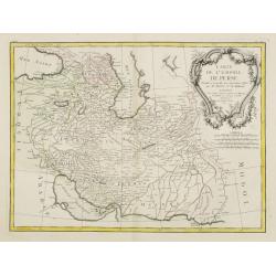
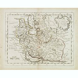
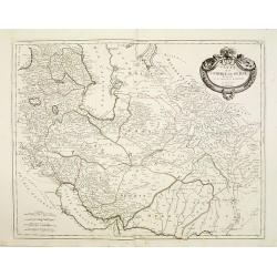
Le Royaume de Perse suivant les nouvelles observations Par J.B.Nolin.
This is a rare map of Persia with modern-day Uzbekistan to the north. The region is labeled as "Grande Tartarie" and "Pays des Usbeks." Bocara (Bukhar...
- $300 / ≈ €260
Date: Paris, 1783
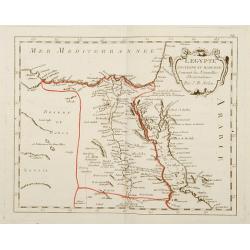
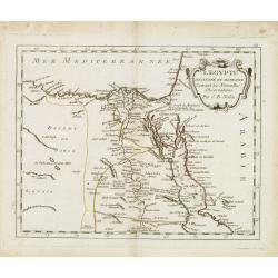
L'Egypte Ancienne et Moderne..
Rare map of Egypt, prepared after J.B.Nolin and published by Monhare for his Atlas Général a l'usage des colleges et maisons d'education.. Louis Joseph Mondhare publish...
- $300 / ≈ €260
Date: Paris, 1783
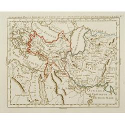
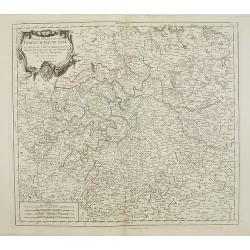
Alexandri Magni Imperium et Expeditio per Africam et potissimum per Aslam.
Rare map of the Empire of Alexander the Great, prepared by J.B.Nolin and published by Monhare for his Atlas Général a l'usage des colleges et maisons d'education.. Cent...
Date: Paris, 1783

Le Basset à jambes droites.
A charming plate from "Histoire Naturelle, Générale et Particulière," Georges Louis Marie Leclerc, comte de Buffon's magnum opus and "the most celebrate...
- $150 / ≈ €130
Date: Paris: Imprimerie Royale, 1749-1783

Le Braque.
A charming plate from "Histoire Naturelle, Générale et Particulière," Georges Louis Marie Leclerc, comte de Buffon's magnum opus and "the most celebrate...
- $150 / ≈ €130
Date: Paris: Imprimerie Royale, 1749-1783
![Le Palmiste [Pl. 121]](/uploads/cache/21920-250x250.jpg)
Le Palmiste [Pl. 121]
A charming plate from "Histoire Naturelle, Générale et Particulière," Georges Louis Marie Leclerc, comte de Buffon's magnum opus and "the most celebrate...
Date: Paris: Imprimerie Royale, 1749-1783
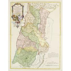
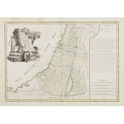
Terrae Sanctae Tabula e Scripturae Sacrae, Flavii Josephi, Eusebii et Divi Hieronymi . . . Delineata.
A very fine map centered on Palestine on both sides of the Jordan, divided among the Tribes and according to the division into provinces of the Roman time.Very nice title...
- $600 / ≈ €519
Date: Paris/ Bordeaux, 1771-1783
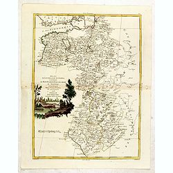
Carte des Douze Tribus d'Israel. . .
Attractive map centered on Israel, ornated with a large decorative title cartouche. Boundaries outlined in hand color.From theAtlas moderne ou collection de cartes sur to...
- $150 / ≈ €130
Date: Paris, ca 1783
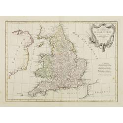
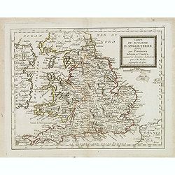
Carte Du Royame D'Angleterre..
Attractive map of England, ornated with a rococo title cartouche. Boundaries outlined in hand color.From theAtlas moderne ou collection de cartes sur toutes les parties d...
- $250 / ≈ €216
Date: Paris, ca 1783
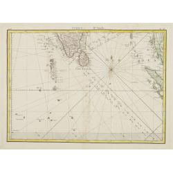
Indes. IIe. Feuille.
Attractive map of the southmost tip of India and Sri Lanka, including the Maldives and part of Sumatra. Boundaries are outlined in hand color.From the "Atlas moderne...
Date: Paris ca 1783
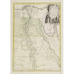
Carte de l'Egypte Ancienne et Moderne..
Attractive map showing part of the course of the river Nile. Boundaries are outlined in hand color.Ornated with a decorative title cartouche representing a crocodile flan...
Date: Paris, ca 1783
![[No title] Northern part of Poland.](/uploads/cache/24263-250x250.jpg)
[No title] Northern part of Poland.
Attractive map centered on the northern part of Poland, including northern part of Eastern Germany.Prepared by Giovanni Antonio Bartolomeo Rizzi Zannoni, one of the leadi...
- $275 / ≈ €238
Date: Paris, ca 1783
Carte de L'Empire D'Alemagne avec les Etats de Bohême..
Attractive map centered on the southwestern part of Germany, including Switzerland, Luxembourg and part of Austria.Decorative title cartouche with wine grapes, musical in...
Date: Paris ca 1783
![[No title] Part of Eastern Europe, including Poland, the Czech Republic, Slovakia and Slovenia.](/uploads/cache/24266-250x250.jpg)
[No title] Part of Eastern Europe, including Poland, the Czech Republic, Slovakia and Slovenia.
Attractive map showing part of the course of the river Danube, from Germany to Hungary.Including Poland, the Czech Republic, Slovakia and Slovenia. Boundaries outlined in...
- $100 / ≈ €87
Date: Paris, ca 1783
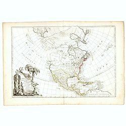
L' Amerique divisée par Grands Etats. . .
Attractive map of America, ornated with a decorative title cartouche. Boundaries outlined in hand color.Prepared by Le Sieur Janvier, Jean denis [Robert], French geograph...
- $450 / ≈ €389
Date: Paris, ca 1783
Carte de l'Empire de Perse. . .
Attractive map of Persia, ornated with a large rococo title cartouche. Boundaries outlined in hand color.From theAtlas moderne ou collection de cartes sur toutes les part...
- $300 / ≈ €260
Date: Paris, ca 1783
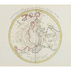
Carte Phisique de la Mer Glaciale Arctique. . .
Very unusual thematic map designed to illustrate the watersheds of the world, after Buache and prepared by J.B.Nolin and published by Monhare for his Atlas Général a l'...
- $300 / ≈ €260
Date: Paris, 1783
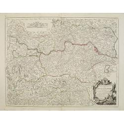
Carte de la Retraite des Dix Mille Accordée aux Observations de l'académie. . .
Ancient map of Near and Middle East prepared by J.B.Nolin and published by Monhare for his Atlas Général a l'usage des colleges et maisons d'education.. Centered on Cyp...
- $100 / ≈ €87
Date: Paris, 1783
Carte du Royaume d'Angleterre. . .
Scarce map of England prepared by Nolin and published by L.J. Mondhare for his Atlas Général a l'usage des colleges et maisons d'education.Louis Joseph Mondhare was act...
- $100 / ≈ €87
Date: Paris, 1783
Représentation du Globe céleste En deux Plans Hémisphères Coupés par l'Ecliptique.
Scarce double armillary sphere prepared by Nolin and published by L.J. Mondhare for his Atlas Général a l'usage des colleges et maisons d'education.. Louis Joseph Mondh...
- $75 / ≈ €65
Date: Paris, 1783
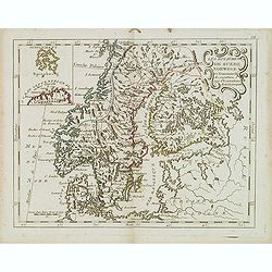
Les Royaumes De Suede Norwege et Danemark. . .
Scarce map of Scandinavia with inset map of Spitsbergen and northern coast of Lapland. Prepared by Nolin and published by L.J. Mondhare for his Atlas Général a l'usage ...
- $100 / ≈ €87
Date: Paris, 1783
Carte de l'Empire d' Allemagne . . .
Scarce map of Germany prepared by de la Fosse and published by L.J. Mondhare for his Atlas Général a l'usage des colleges et maisons d'education.. Louis Joseph Mondhare...
- $50 / ≈ €43
Date: Paris, 1783
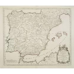
Les royaumes d'Espagne et de Portugal. . .
Scarce map of Spain and Portugal prepared by Nolin and published by L.J. Mondhare for his Atlas Général a l'usage des colleges et maisons d'education.. Louis Joseph Mon...
- $100 / ≈ €87
Date: Paris, 1783
Turquie Asiatique. . .
Scarce map of Turkey prepared by Nolin and published by L.J. Mondhare for his Atlas Général a l'usage des colleges et maisons d'education.. Louis Joseph Mondhare was ac...
- $100 / ≈ €87
Date: Paris, 1783
Le royaume de Perse. . .
Scarce map of Persia prepared by Nolin and published by L.J. Mondhare for his Atlas Général a l'usage des colleges et maisons d'education.. Louis Joseph Mondhare was ac...
Date: Paris, 1783
L'Egypte. . .
Scarce map of Egypt, prepared by Nolin and published by L.J. Mondhare for his Atlas Général a l'usage des colleges et maisons d'education.. Louis Joseph Mondhare was ac...
- $75 / ≈ €65
Date: Paris, 1783
Partie septentrionale de l'Afrique contenant l'Egipte. . .
Scarce map of northern part of Africa, prepared by Nolin and published by L.J. Mondhare for his Atlas Général a l'usage des colleges et maisons d'education.. Louis Jose...
- $150 / ≈ €130
Date: Paris, 1783
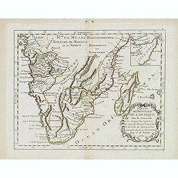
Partie meridionale de l'Afrique ou se trouvent le Congo. . .
Scarce map of south of Africa with Madagascar, prepared by Nolin and published by L.J. Mondhare for his Atlas Général a l'usage des colleges et maisons d'education.. Lo...
- $200 / ≈ €173
Date: Paris, 1783
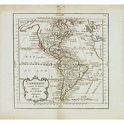
L'Amérique suivant les dernier. . .
Scarce map of America, prepared by Nolin and published by L.J. Mondhare for his Atlas Général a l'usage des colleges et maisons d'education.. Louis Joseph Mondhare was ...
- $200 / ≈ €173
Date: Paris, 1783
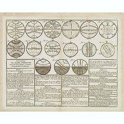
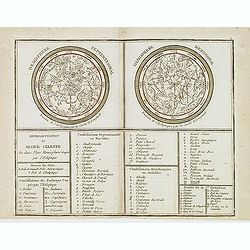
Divisions du Globe Terrestre en Cercles, Zônes, Climats, Longitudes et Latitudes.
A scarce print showing 15 globes, each globe showing different zones published by Mondhare for his Atlas Général a l'usage des colleges et maisons d'education.. Underne...
- $75 / ≈ €65
Date: Paris, 1783
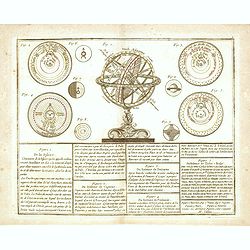
De la Sphère. . .
Scarce print of armillary sphere, surrounded by several diagrams of the sun, moon, and planets after Cassini. In lower part 9 blocks of text with explanations.Published b...
Date: Paris, 1783
Plan et coupe horisontale du labyrinte souterrain de Koungour Renvoi.
Engraved map of the Urals with the town Kungur in Russia. With a lettered key A-P in left corner. From the Atlas Volume of "Histoire physique, morale, civile et poli...
Date: Paris, 1783
Russie d'Europe avec la partie la plus peuple de celle d'Asie...
A detailed map covering what was 'Russia in Europe', toward the end of the eighteenth century. Decorated with a decorative title cartouche, and an 'Advertisement'.Boundar...
- $150 / ≈ €130
Date: Paris, ca 1783
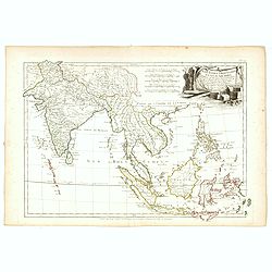
Les Indes Orientales et leur Archipel. . .
General map of Indonesia, extending from India to the Philippines and New Guinea.Ornated with a decorative title cartouche. Boundaries outlined in hand color.From theAtla...
- $250 / ≈ €216
Date: Paris, ca 1783
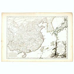
L'Empire de la Chine d'après l'Atlas Chinois, avec les Isles du Japon..
Attractive map of eastern part of China, including Taiwan, Korea and Japan. With ornamental title cartouche. Boundaries outlined in hand color.From theAtlas moderne ou co...
- $300 / ≈ €260
Date: Paris, ca 1783
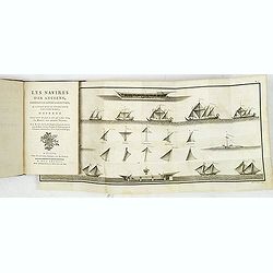
Les Navires des anciens, considérés par rapport à leurs voiles et à l'usage qu'on en pourroit faire dans notre marine, ouvrage servant de suite à celui qui a pour titre ela Marine ...
First edition. The book is giving a description of the different ship types of all parts of the world from its early times till present (1780). Illustrated with 3 folding...
- $900 / ≈ €779
Date: Paris, Nyon, 1783
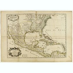
Carte du Mexique et des Etats Unis d'Amérique...
A later edition of De l'Isle's foundation map of 1703 is widely regarded as one of the most influential maps in the history of American Cartography. This updated version ...
Date: Paris, 1783
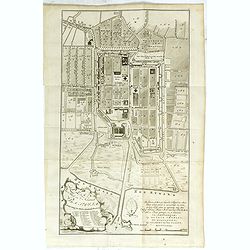
Plan der Stad en ‘t Kasteel BATAVIA. Aanwyzing der Stad en Kasteels Punten.
Very fine decorative plan of present-day Jakarta, showing the City and its immediate environs, the surrounding rice fields intersected by a network of waterways, canals a...
- $1750 / ≈ €1515
Date: Amsterdam, 1782-1783
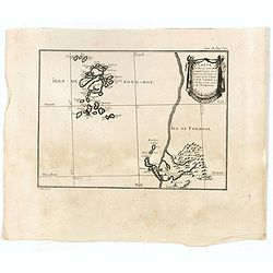
Carte des Iles de Ponghou suivant le point sur lequel ont été faites les cartes de la Chine et de la Tartarie par l'ordre et aux frais de l'empereur. . .
Plan of the West coast of Taiwan and it direct environs. From "Lettres Édifiantes et Curieuses. . Missionaires de la Compagnie de Jesus [Jesuit Letters]". Engr...
- $175 / ≈ €151
Date: Paris, 1780-1783
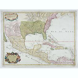
Carte du Mexique et des Etats Unis d'Amérique…
A later edition of De l'Isle's foundation map of 1703, widely regarded as one of the most influential maps in the history of American Cartography. This updated version o...
Date: Paris, 1783

Carte de la Suisses . . .
Scarce map of Switzerland prepared by de la Fosse and published by L.J. Mondhare for his Atlas Général a l'usage des colleges et maisons d'education.. Louis Joseph Mond...
- $100 / ≈ €87
Date: Paris, 1783

Carte Générale du Canada, de la Louisiane, de la Floride, de la Caroline..
Map of the eastern part of the United States and Canada. With inset map of Hudson and Baffin bays. in the lower right corner.Venetian edition of d'Anville's map, from &qu...
Date: Venice, 1776 - 1784
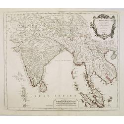
Les Indes Orientales.. tirées du Neptune Oriental..
Finely and crisply engraved map centered on the Bay of Bengal, encompassing the Indian subcontinent and the Indochinese Peninsula.Venetian edition of Giles Didier Robert ...
- $450 / ≈ €389
Date: Venice, 1779 - 1784
Carte de l'Empire de Perse...
Finely and crisply engraved map of the Persian Empire during the 18th century. It shows the Caspian Sea in the north to the Persian Gulf in the south, and from Armenia in...
Date: Venice, 1779 - 1784
Hispania Antiqua in tres praecipuas partes..
Map of the Hibernia peninsula and the Balearic Islands. With a rococo title cartouche in the lower right corner.Venetian edition of Giles Didier Robert De Vaugondy's map ...
Date: Venice, 1776 - 1784
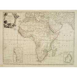
L'Afrique divisée en ses principaux Etats assujettie..
Excellent copper engraved map of the continent showing the extent of knowledge in the mid-18th century.While mostly accurate, it does have remnants of fantasy such as the...
- $400 / ≈ €346
Date: Venice, 1776 - 1784
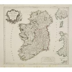
Royaume d'Irelande.. et subdivisé en Comtés.
Finely and crisply engraved map of Ireland.Venetian edition of Giles Didier Robert De Vaugondy's map from Atlas Universel printed in 1776-84.Ornamental title cartouche in...
Date: Venice, 1776 - 1784
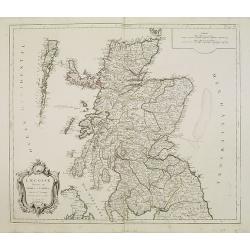
L'Ecosse divisée en Shires et Comtés.
Finely and crisply engraved map of Scotland.Venetian edition of Giles Didier Robert De Vaugondy's map from Atlas Universel printed in 1776-84.Ornamental title cartouche i...
Date: Venice, 1776 - 1784
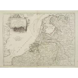
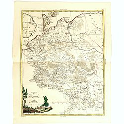
Partie septentrionale des Pays-Bas comprenant .. des provinces unies. . .
Finely and crisply engraved map of Netherlands.Venetian edition of Giles Didier Robert De Vaugondy's map from Atlas Universel printed in 1776-84.Ornamental title cartouch...
Date: Venice, 1776 - 1784
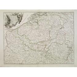
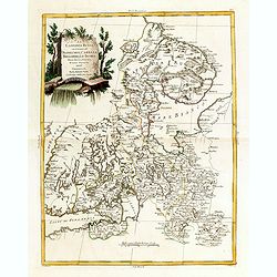
Partie meridionale des Pays Bas.. Cambrefis et Artois.
Finely and crisply engraved map of Belgium, including southern part of Netherlands and part of Germany.Venetian edition of Giles Didier Robert De Vaugondy's map from Atla...
Date: Venice, 1776 - 1784
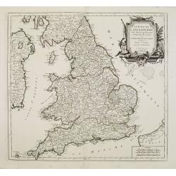
Le royaume d'Angleterre..subdivisé en Shires ou Comtés.
Finely and crisply engraved map of British Isles including the coasts of France and Ireland.Venetian edition of Giles Didier Robert De Vaugondy's map from Atlas Universel...
Date: Venice, 1778 - 1784
Cercle de Haute Saxe.
Finely and crisply engraved map of Germany, centered on Leipzig .Venetian edition of Giles Didier Robert De Vaugondy's map from Atlas Universel printed in 1776-84.Ornamen...
Date: Venice, 1776 - 1784
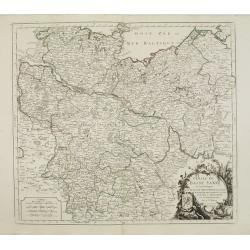
Cercle de Basse Saxe où sont distingués les états de ... et des évêchés d'Hildesheim et d'Halberstadt par le Sr. Robert.
Finely and crisply engraved map of northern part of Germany, including the river Elbe, with Hamburg until Potsdam. In the upper right the Baltic coast including Wismar, R...
- $150 / ≈ €130
Date: Venice, 1776 - 1784
Partie Septentrionnale du Cercle d'Autriche.. Duché de Stirje.
Finely and crisply engraved map of Austria, centered on Vienna.Venetian edition of Giles Didier Robert De Vaugondy's map from Atlas Universel printed in 1776-84.Ornamenta...
- $90 / ≈ €78
Date: Venice, 1776 - 1784