Browse Listings in Maritime
![[Navigational chart].](/uploads/cache/37971-250x250.jpg)
[Navigational chart].
Two text engravings from "Premier livre de l'histoire de la navigation aux Indes Orientales, par les hollandois, et des choses a eux advenues . . . ", being the...
Date: Amsterdam, Cornille Nicolas, 1609
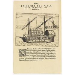
XXVII. Triremes seu Galiottae et Fustae Iavenenfium. 21. ( A typical Javanese man-of-war ship)
A typical Javanese man-of-war ship. The Javanese call their man-of-war ships, Cathurs. The slaves are all seated below deck and do the rowing with oars, while the warrior...
- $150 / ≈ €131
Date: Frankfurt, 1609
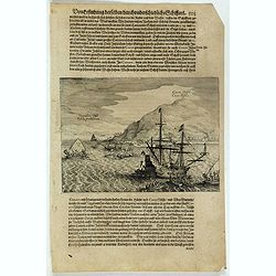
![[Ternate].](/uploads/cache/37954-250x250.jpg)
[Ternate].
Text engraving showing a bay on the Island of Ternate, an island in the Maluku Islands (Moluccas) of eastern Indonesia. Above the map a lettered key (A-E). Text engraving...
- $100 / ≈ €87
Date: Amsterdam, Cornille Nicolas, 1609
![[Javanese Vessels]](/uploads/cache/37947-250x250.jpg)
[Javanese Vessels]
Two text engravings from "Premier livre de l'histoire de la navigation aux Indes Orientales, par les hollandois, et des choses a eux advenues . . . ", being the...
- $100 / ≈ €87
Date: Amsterdam, Cornille Nicolas, 1609
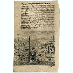
![[Foreign Merchants at Bantam].](/uploads/cache/37943-250x250.jpg)
[Foreign Merchants at Bantam].
Two text engravings from "Premier livre de l'histoire de la navigation aux Indes Orientales, par les hollandois, et des choses a eux advenues . . . ", being the...
- $100 / ≈ €87
Date: Amsterdam, Cornille Nicolas, 1609
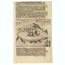
![[View of the arrival of Cornelis de Houtman's fleet at Bantam, Java.].](/uploads/cache/37937-250x250.jpg)
[View of the arrival of Cornelis de Houtman's fleet at Bantam, Java.].
Engraved map of Bantam on Java with a lettered key (A-N) showing the arrival of Cornelis de Houtman’s fleet at Bantam, Java in 1596. Houtman’s four vessels, the Amste...
- $200 / ≈ €175
Date: Amsterdam, Cornille Nicolas, 1609
![[The attack by Schouten and his men on a waka.]](/uploads/cache/39658-250x250.jpg)
[The attack by Schouten and his men on a waka.]
Scarce print on French text sheet showing the attack by Schouten and his men on a waka.From a description of the voyage of Le Maire and Schouten included in the first Fre...
- $200 / ≈ €175
Date: Amsterdam, 1622
Cocos Insel Cocos Insula / Verräter Insel Insula proditorum.
Scarce print (148x204mm.) on a German text sheet showing the landing of Le Maire and Schouten at Cocos Island in May 1616 (today’s Tafahi in the Tonga Islands). Named b...
- $150 / ≈ €131
Date: Frankfurt, M.Merian, 1631
Vligen Insel.
Scarce print (168x200mm.) on a German text sheet showing the attack of mosquitos on Schouten's ship.The page is taken from a first edition of Johann Ludwig Gottfried's &q...
- $75 / ≈ €66
Date: Frankfurt, M. Merian, 1631
![[The attack by Schouten and his men on a waka.]](/uploads/cache/39754-250x250.jpg)
[The attack by Schouten and his men on a waka.]
Scarce print (145x210mm.) on a German text sheet showing the attack by Schouten and his men on a waka.The page is taken from a first edition of Johann Ludwig Gottfried's ...
- $150 / ≈ €131
Date: Frankfurt, M.Merian, 1631
![[How the Indians cross the river.]](/uploads/cache/40477-250x250.jpg)
[How the Indians cross the river.]
The Indians of Peru had strange ways of crossing rivers. They tied a rope between two poles on either side of a river, then they hung a large basket from this rope and wh...
Date: Frankfurt, M.Merian, 1633
![[The Dutch reach Annabon.]](/uploads/cache/40075-250x250.jpg)
[The Dutch reach Annabon.]
Eight days after leaving the mainland, the Dutch arrived at one of the Annabon islands (Pagalu), where they asked the Portuguese and Moors, who were occupying the island,...
Date: Frankfurt, M.Merian, 1633
Solor.
Scarce print on German text sheet showing the Island of Solor. From "Petits Voyages". The island Solar, to the north of Timor, has a high mountain and has a ver...
- $100 / ≈ €87
Date: Frankfurt, M.Merian, 1633
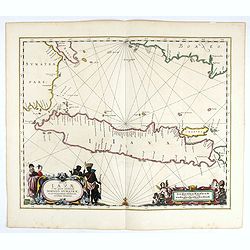
Insulae Iavae Cum parte insularum Borneo Sumatrae..
An elegant sea chart of the island of Java with parts of Sumatra, Borneo and Bali. The map includes only coastal detail and shows the Dutch capital in the East Indies at ...
Date: Amsterdam, 1652

Mappa Aestivarum Insularum alias Barmudas.
Blaeu based his work on John Speed's remarkably accurate map of 1626-1627. It shows the island divided into tribes and lots, and below the map itself appear the names of ...
Date: Amsterdam, 1662

Pas-Caart van Guinea en den Custen daer aen gelegen Van C..
A decorative chart of the southwest coast of Africa, embellished with an elaborate, finely colored title-cartouche, and 2 compass-roses. Pieter Goos (ca. 1616-1675) was o...
Date: Amsterdam, 1666

De Cust van Barbaria, Gualata, Arguyn, en Gene..heo, van Capo S.Vincente tot Capo Verde.
An eye-catching chart of the north western coast of Africa. Including Canary Islands, Cape Verde Islands and Azores.Pieter Goos (ca. 1616-1675) was one of the most import...
Date: Amsterdam, 1666

De Cust van Barbaryen van out Mamora tot Capo Blanco..
Six charts on one sheet. The two upper charts covering an area from Cape Blanc to Casablanca. In lower part four insets with detailed charts of islands as Madera, Porto S...
Date: Amsterdam, 1666

Cimbebas et Caffariae Littora a Catenbela ad Promontorium. . .
The coast of Angola, South-West Africa and South Africa up to Port Elizabeth. Classic sea chart of Dutch school with excellent baroque embellishment. North oriented to th...
Date: Amsterdam, 1675
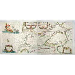
Paskaerte van het inkoomen van de MAES, Tot aen 't Eylandt Roosenburgh als mede 't Inkoomen van 't Goereesche Gat.. / Pascaert van 't Eylandt Roosenburg door de Oude en Nieuwe Maes....
A very attractive sea chart on two sheets of the mouth of the river Maas. The left sheet shows Dordrecht, Rotterdam and the fortress at Willemstad. Rghthand sheet dep...
Date: Amsterdam, 1680

Paskaart van de kust van Maroca beginnende van Larache tot aan C. Cantin. . .
A nautical sea chart of the coast of Morocco. Insert at top right: 'Nieuwe Afbeelding van de Rivier Rio Rebata in 't Groot".Bottom right: chart number '32'. Compass ...
Date: Amsterdam, ca.1682
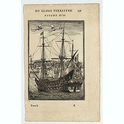
Vaisseau.
Miniature view of a vessel, showing its various corposants. With key list on verso.From the French text edition of Description d'Univers.. (5 volumes), 1683. By Allain Ma...
- $80 / ≈ €70
Date: Paris, 1683
Ladimistri nel arcipelago. (Edremit)
Magnificent bird's eye-town-view of Edremit on the west coast of Turkey, not far from the Greek island Lesbos. It is situated at the tip of the gulf with the same name (G...
- $150 / ≈ €131
Date: Antwerp, c.1690
Canistro nel Arcipelago.
Magnificent view of Kanaestreo and its harbour front, decorated with ships and rowing boats in a rough sea. Engraved by Lucas Vostermans II, who was born in 1624, in the ...
- $100 / ≈ €87
Date: Antwerp, c.1690
Ware affbeeldinge wegens het casteel ende stadt Batavia. . .
A reduced version of Clement de Jonghe (1650) plan of Jakarta from 1650. The town plan has a vignette at the bottom showing Jakarta from the sea with the volcanoes Mount ...
- $800 / ≈ €699
Date: Leiden, 1719
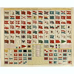
Carte des pavillons accompagnée d'observations pour en faire comprendre le blazon et les différentes devises aussy bien que d'une table alphabétique pour les trouver facilement.
A plate of 88 marine flags, including Malta, Turkey, Middelburg, Amsterdam, Portugal, Monaco, Tuscany, China, Nanking, the French Royal flag, the French admiralty flag an...
- $1200 / ≈ €1048
Date: Amsterdam, 1720

Carte de l'Ile de Java. . .
An inset plan of Batavia clearly indicates rice fields, mountains, forests, towns in profile, and even elephants, suggesting the wealth of detail found on this map. Model...
Date: Amsterdam, 1720
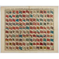
Flaggen aller seefahrenden potenzen und nationen…
A highly decorative and beautiful print with 139 flags of the sea-faring nations, factions, and trading companies. Among the more interesting flags are those of the Dutch...
Date: Nuremberg, 1750
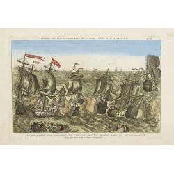
Vue perspective d'une rencontre des François avec les Anglois dans la Mediterranée.
Perspective view illustrating a battle between the French and the English fleets by Basset, a well-known publisher of optical prints, established in rue S. Jacques in Par...
- $300 / ≈ €262
Date: Paris, 1760
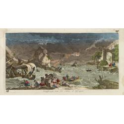
Naufrage sur les côtes d'Afrique.
So called optical print of a shipwrecking in a storm off the African shores.In the eighteenth and nineteenth centuries there were many popular specialty establishments in...
- $300 / ≈ €262
Date: Paris, 1760
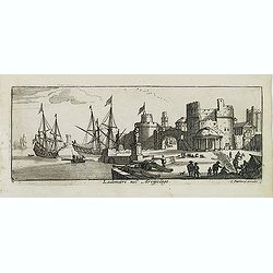
![[60] Porto de Ganea.](/uploads/cache/12832-250x250.jpg)
[60] Porto de Ganea.
Charming chart of the harbour of the Greek town of Ganea. Showing town and harbour plan, with soundings, anchorages, rocks, shoals, fortifications and lighthouses.Joseph ...
Date: Marseille, 1764
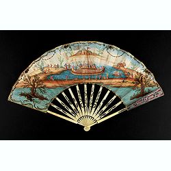
A folding fan showing a nautical festival, ca. 1770.
Folded fan, painted in gouache a ship pulled by two horses. On board, a large company, among others joins them while fishermen watch the scene.Reverse painted with an exo...
- $1500 / ≈ €1310
Date: France, ca. 1770
![Le Capitaine Wallis est attaqué dans le Dauphin par les Otahitiens. [Tome II Pl. 1ère.]](/uploads/cache/26099-250x250.jpg)
Le Capitaine Wallis est attaqué dans le Dauphin par les Otahitiens. [Tome II Pl. 1ère.]
Scene of an attack by local Tahitians on Captain Wallis' Dolphin ship off Tahiti's shore. Samuel Wallis (1728-95), a Royal Navy Captain and a skilled navigator was given ...
- $150 / ≈ €131
Date: Paris, 1773

Carte de la Côte de Guzerat, Du Golf de Cambaye et des Côtes de Concan et De Canara.
French sea chart of West India from Gujarat to Mangalore. With inset chart Plan de la Rivière de Surate.Prepared by Jacques-François L'Abbé Dicquemare (1733-1789). La...
Date: Paris, ca 1775
Le Rachat de l'Esclave.
With a dedication to Monseigneur Anne Robert Jacques Turgot Ministre d'Etat, Controlleur Général des Finances. Engraved by J. Aliamet (1726-1788) after Nicolaes Pieters...
- $300 / ≈ €262
Date: Paris, Aliamet, ca. 1785
Embarquement de vivres.
With a dedication to Monseigneur le Comte de Saint Florentin Commandeur des Ordres du Roy. Engraved by Jac. Philippe Le Bas, who was also engraver for "Cabinet du Ro...
- $500 / ≈ €437
Date: Paris, ca. 1785
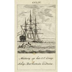
Muitery op het O:I: Comp. schip Barbestein in Duins.
Anonymous engraving of a mutiny of the VOC ship Barbestein .
Date: Amsterdam c.1790

Neptune des Côtes Occidentales de France.
Large maritime atlas illustrated with a handwritten title, a table, and 47 single or double-page charts. The charts show the western coasts of France as well as the Spani...
- $12000 / ≈ €10483
Date: Paris, 1776-1822
Shipping
Attractive lithography showing Dutch vessels off the Dutch coast, by F.A.Breuhaus de Groot. Published in Kunst Kroniek.
Date: The Hague, 1849
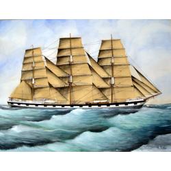
Original Maritime painting of the 'Cape Horn' , a so-called captain's ship drawing by R. Takes
A fine example of a so-called 'captain's portrait' of a clipper-ship under full sail.The name of the ship at the bow reads "Cape Horn" Signed in the lower right...
Date: c. 1850
Kronborg et le Sund (Danemarck).
Uncommon and decorative lithography published by Carl Johan Billmark and printed by Lemercier in Paris, 55 rue de Seine, the leading firm in Europe at that time. From: It...
- $75 / ≈ €66
Date: Paris, c.1859

L'escadre alliée bombarde les forts extérieurs de Sébastopol. (18 octobre 1854)
Beautiful Crimean War lithography by Becquet after a painting by Louis Le Breton. The print illustrates the ships "Fort Constantin", "la ville de Paris&quo...
Date: Paris, 1860
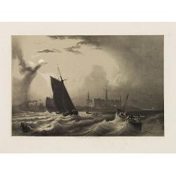
![[Ships at sea]](/uploads/cache/08213-250x250.jpg)
[Ships at sea]
Attractive lithography showing Dutch vessels off the Dutch coast, by F.H.Weissenbruch after a painting by L.Meijer. Published in Kunst Kroniek .
Date: The Hague, 1862

The East Asiatic Company.
Very decorative and uncommon 'The East Asiatic Company' poster by Kolind. Depicting a sailor loading or unloading a ship.The East Asiatic Company (EAC) came into being in...
- $650 / ≈ €568
Date: Egmont H. Petersen, København, 1950
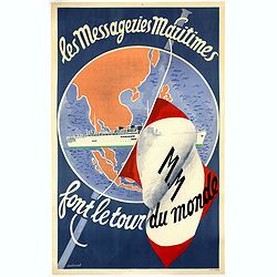
Les Messageries Maritimes font le tour du monde.
Original lithographed poster created by the artist Robert Louis Antral for Les Messageries Maritimes, showing a boat and a globe. Les Messageries Maritimes Company (MM) i...
- $900 / ≈ €786
Date: Paris, 1955
