Browse Listings in Map-fair Highlights
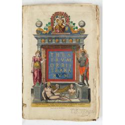
Theatrum Orbis Terrarum.
A Dutch edition of Ortelius' Theatrum Orbis Terrarum "Ghedruckt voor A. Ortelius" (by Corn. Claesz.?), 1598. Illustrated with 92 maps, 91 maps numbered 1-91, in...
- $100000 / ≈ €87355
Date: (Amsterdam, Corn. Claesz.) ?, 1598
!['T Derde deel van 't Licht der zee-vaert, inhoudende de beschryvinghe der zeecusten van de Middelandtsche Zee /, By een vergaedert ende in't licht ghebracht door Willem Janssen. [Blaeu sea atlas].](/uploads/cache/49048-250x250.jpg)
'T Derde deel van 't Licht der zee-vaert, inhoudende de beschryvinghe der zeecusten van de Middelandtsche Zee /, By een vergaedert ende in't licht ghebracht door Willem Janssen. [Blaeu sea atlas].
Extremely rare W. Blaeu's Sea Atlas describing the coasts and islands of the Mediterranean Sea, published in Amsterdam by W. Blaeu" Tot Amsterdam, by Willem Jansz. ...
- $150000 / ≈ €131033
Date: Amsterdam, 1618
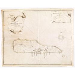
Descripcion de la Isla de Curaçao; Sacada de los Papeles que vinieron a el R.L Consejo de las Indias d. Fran.co Núñez Melián Gouvernador de Venezuela fechos en Caracas en 4° de Diciembre, de 1634 Anos
JUAN DE HERRERA Y ADUILAR - Descripcion de la Isla de Curaçao; Sacada de los Papeles que vinieron a el R.L Consejo de las Indias d. Fran.co Núñez Melián Gouvernador...
Date: Sevillia, c.1635-1652
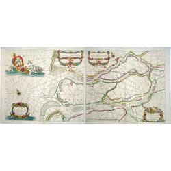
Paskaerte van het inkoomen van de MAES, Tot aen 't Eylandt Roosenburgh als mede 't Inkoomen van 't Goereesche Gat.. / Pascaert van 't Eylandt Roosenburg door de Oude en Nieuwe Maes....
A very attractive sea chart on two sheets of the mouth of the river Maas. The left sheet shows Dordrecht, Rotterdam and the fortress at Willemstad. Rghthand sheet dep...
Date: Amsterdam, 1680
