Browse Listings
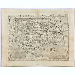
Tabula Europae II. (Spain and Portugal)
Gastaldi's map showing Spain and Portugal, based upon Ptolemy.It is one of the earliest obtainable maps of the region.From Giacomo Gastaldi's Atlas of 1548 which has been...
- $375 / ≈ €325
Date: Venice, 1548
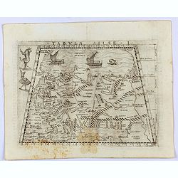
Tabula Asiae I.
Gastaldi's map of Asia Minor and the Bosporus Straits, based upon Ptolemy.It is one of the earliest obtainable maps of the region .From Giacomo Gastaldi's Atlas of 1548 w...
- $400 / ≈ €346
Date: Venice, 1548
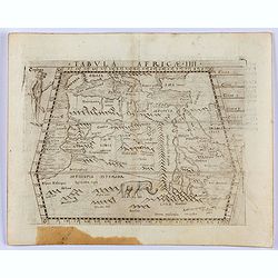
Tabula Africae IIII.
Gastaldi's map of Northern Africa, based on Ptolemy. Showing all of the Mediterranean, the Ethiopian Interior, the Red Sea, Egypt, the source of the Nile, the Dead Sea, e...
- $400 / ≈ €346
Date: Venice, 1548
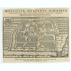
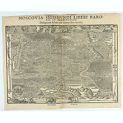
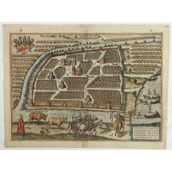
Moscovia Sigismundi Liberi Baronis In Herberstein, Neiperg et Gutehnag Anno M.D XLIX
The forst modern plan of Moscow. A rare and important cornerstone map for Russia collections.Sigismund von Herberstein made two visits to Russia. In 1517-18 he travelled ...
Date: Vienna, 1549
Moscovia Sigismundi Liberi Baronis In Herberstein, Neiperg et Gutehnag Anno M.D XLIX
First Modern Map of Russia. A rare and important cornerstone map for Russia collections.Sigismund von Herberstein made two visits to Russia. In 1517-18 he travelled as a ...
Date: Vienna, 1549

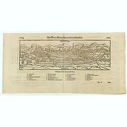
Della Graecia Ritratto di Costantinopoli hora stanza del Turco.
Early bird's eye view of Constantinople. From an Italian text edition of S. Münster's Cosmographia, which is a short and complete summary of Renaissance knowledge.
Date: Basle, 1550
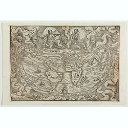
Typus Universalis Terrae, Iuxta Modernorum Distinctionem Et Extensionem Per Regna Et Provincias.
Rare world map from Gregor Reisch's Magarita Philisophica published in Basle in 1583.In 1544, Peter Apian incorporated a world map into his Cosmographia, based upon Gemma...
Date: Antwerp c.1550
![[Lot of 2 leaves] Rubeaquum cum arce Isenburgo…/ Wyssenburg…](/uploads/cache/48269-250x250.jpg)
[Lot of 2 leaves] Rubeaquum cum arce Isenburgo…/ Wyssenburg…
Two wood block printed early bird's-eye views of Rouffach (lies along the Alsatian wine route) and Wissembourg (Alsace). From the 1552 Latin text edition of Münster's Co...
Date: Basel, 1552
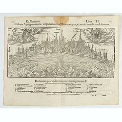
Colonia Agrippina civitas…
A wood block printed early panoramic view of Cologne (Germany). A lettered key A-Z beneath the view. The 1552 Latin text edition of Münster's Cosmographia is a short and...
- $70 / ≈ €61
Date: Basel, 1552
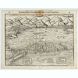
Lindoiae civitas insularis, undique aqua lacunari circunsusa.…
A wood block printed early bird's-eye view of Lindau on Lake Constance (Germany). A lettered key A-O in the plate. From the 1552 Latin text edition of Münster's Cosmogra...
- $70 / ≈ €61
Date: Basel, 1552
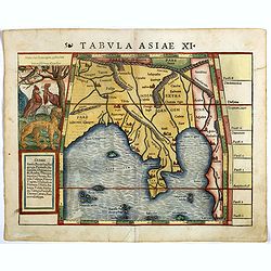
Tabula Asiae XI.
Attractive early woodblock map of the Indian Ocean, extending from Southeast Asia to the Ganges River and north to the Himalayas.In upper left inset panel of tiger, cocke...
- $600 / ≈ €519
Date: Basle, H. Petri, c. 1552
![[Lot of 6 leaves] Civitas Augustana olim Vindelica…/Sueviae et Bavariae Descriptio/ Franckfordiae ad Oderam imago…/Franckofordianae civitatis…/Erdfordia magnifica …Thuringoru urbs…Fuldensis civitatis… / Lubecum una ex praeclarioribus. . .](/uploads/cache/48258-250x250.jpg)
[Lot of 6 leaves] Civitas Augustana olim Vindelica…/Sueviae et Bavariae Descriptio/ Franckfordiae ad Oderam imago…/Franckofordianae civitatis…/Erdfordia magnifica …Thuringoru urbs…Fuldensis civitatis… / Lubecum una ex praeclarioribus. . .
Six text leaves with wood block printed views and maps of Augsburg, Frankfurt /Oder, Frankfurt am Main, Erfurt and Fulda, Lübeck and a map of Swabia and Bavaria. From th...
Date: Basel, 1552
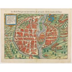
La ville de Paris, par tout tant renommée & principalle ville du royaulme de France.
Very early birds-eye view of Paris. From his Cosmographia, that great compendium of Renaissance knowledge. An exciting print.Engraved by Hans Rudolf Manuel-Deutsch(1525-1...
Date: Bâle, H. Petri, 1552
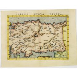
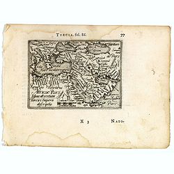
Natolia nuova tavola.
Uncommon first edition of this early map of Turkey.Girolamo Ruscelli's edition of Ptolemy's Geographia included newly engraved copperplates by Giulio and Livio Sanuto. Th...
- $375 / ≈ €325
Date: Venice, 1561
![Arabia Felice Nuova Tavola. [Arabian Peninsular]](/uploads/cache/40089-250x250.jpg)
Arabia Felice Nuova Tavola. [Arabian Peninsular]
Fine early map of this modern depiction of the Arabian peninsula, being one of the earliest modern maps of the region. The map extends from the Arabian Desert south as fa...
Date: Venice, Vincenzo Valgrisi, c.1561
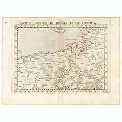
Tavola nuova di Prussia et di Livonia.
Uncommon first edition of this early map of the region from Pomerania to Livonia, includes a portion of Estonia, and coastal detail on the Baltic Sea with a small section...
Date: Venice, Vincenzo Valgrisi, 1561
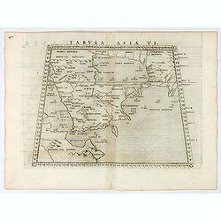
Tabula Asiae VI.
Uncommon first edition of this classical map of the Arabian Peninsular, is an enlarged version of Giacomo Gastaldi's published in 1548Girolamo Ruscelli's edition of Ptole...
Date: Venice, 1561
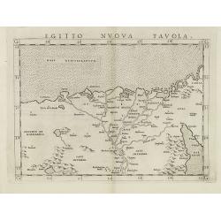
Egitto nuova tavola.
Fine early map of Egypt and the Nile delta. Extends east to the Upper Red Sea and West to "Deserto De Marmarica". Nice detail in the lower Nile regions. Page ta...
- $200 / ≈ €173
Date: Venice, 1561
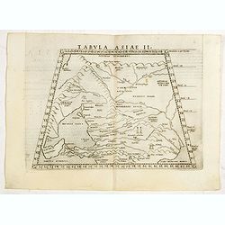
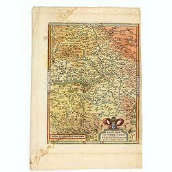
Tabula Asiae II.
Scarce FIRST edition of this map of the ancient region of Asiatic Sarmatia - now Southern Russia and part of Ukraine, around the Azov seaGirolamo Ruscelli's edition of Pt...
- $300 / ≈ €260
Date: Venice, 1561
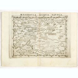
Moschovia nuova tavola.
Scarce FIRST edition of this map centered on Moscow. In the lower left Crimea and the Sea of Azov. The map is filled with small tents to represent Tartar camps.Girolamo R...
- $300 / ≈ €260
Date: Venice, 1561
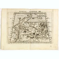
Tabula Europae IIII.
The scarce FIRST edition of this classical map depicting Northern Europe, Denmark and the Baltic. Includes engravings of a number of interesting animals in the right-hand...
- $450 / ≈ €389
Date: Venice, 1561
-250x250.JPG)
Fiandra Brabantia et Holanda nvova
Fiandra Brabantia et Holanda nvovaDella Fiandra Brabantia, et Olanda quinta nvova tavola d’EuropaThis map is the first known map of the Netherlands as a whole. It comes...
Date: Venetië, 1561
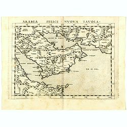
Arabia Felice Nuova Tavola.
Uncommon first edition of this modern map of Saudi Arabia, the Persian Gulf and Red Sea, for the first time it "clearly shows the island of Bahrain and Qatar".T...
Date: Venice, Vincenzo Valgrisi, 1561
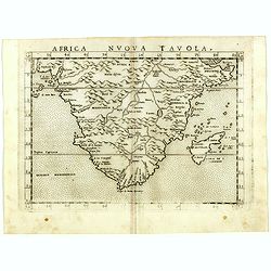
Africa nuova tavola.
Uncommon first edition of this early map of South Africa. Madagascar is called Isola de S. Lorenzo and is oddly shaped.The origin of the Nile conforms to the Ptolemaic co...
- $550 / ≈ €476
Date: Venice, Vincenzo Valgrisi, 1561
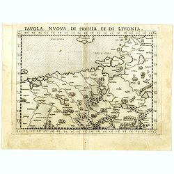
Tavola nuova di Prussia et di Livonia.
Uncommon first edition of this early map of the region from Pomerania to Livonia, includes a portion of Estonia, and coastal detail on the Baltic Sea with a small section...
- $400 / ≈ €346
Date: Venice, Vincenzo Valgrisi, 1561
![[Tartaria].](/uploads/cache/37427-250x250.jpg)
[Tartaria].
One text page with a woodcut map of Tartary. On verso, a woodcut of a horse and a figure holding a wipe, from Münster's Cosmographia Universalis.The Cosmographia by Seba...
- $80 / ≈ €69
Date: Basle, ca. 1564
![Groeninga MDLXXIII. [Groningen]](/uploads/cache/27192-250x250.jpg)
Groeninga MDLXXIII. [Groningen]
RECTO: A panoramic view of the city of Groningen dated 1573.VERSO: a woodcut of a cow, a bull and their calf.Taken from Sebastian Munster's encyclopedic work, the "C...
Date: Basle, ca. 1564
![[No title] 'Daniel's Dream Map' or 'Wittenberg World Map'.](/uploads/cache/34785-250x250.jpg)
[No title] 'Daniel's Dream Map' or 'Wittenberg World Map'.
Wood block print engraved by the famous engravers Jost Amman and Virgil Solis - with their initials in lower bottom of the map. This somewhat curious map of Europe, Afric...
Date: Cologne, ca. 1564
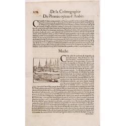
Meche.
Panoramic view of Mecca from Antoine du Pinet's "Plantz, Pourtraitz, Et descriptions De Plusieurs Villes". Woodblock print in text leaf with an interesting desc...
Date: Lyon, 1564
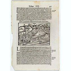
De Lucerna Helvetiorum Civitate. (Luzern)
One Latin text page with a wood cut bird's-eye view of Luzern (147x157mm). From Münster's Cosmographia Universalis. The Cosmographia by Sebastian Münster from 1544 is t...
- $50 / ≈ €43
Date: Basle, ca. 1564
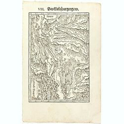
VIII. Das Wiflispurgergow.
Very early wood cut printed regional map of Switzerland with Lake Geneva.Originally engraved in 1548. The map was prepared by Johannes Stumpf (1500-1576). Included in &qu...
Date: Zurich, Christoffel Froschover, 1548,1552-1566
DESCRIPTION DE TOUT LE PAIS BAS Autrement dict La Germanie Inferieure, ou Basse-Allemaigne…
First French edition. Illustrated with a coat of arms and portrait of Philips II, with a folding map of The Netherlands and maps and views of Brabant, Louvain, Brussel, A...
- $4500 / ≈ €3895
Date: Anvers. Guillaume Silvius, 1567
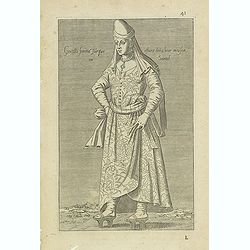
Gentille femmé Turque estant dans leur maison ou Sarail. (41)
Sought-after copper engraved plate from Laonikos Chalcocondyle’s "L'histoire de la décadence de l'empire grec et establissement de celuy des Turcs." by Thoma...
Date: Lyon, 1567
-250x250.jpg)
La descrittione di Belgica con le sve frontiere (maps of the Seventeen Provinces)
La descrittione di Belgica con le sve frontiere Omnis Belgica intra Rhenum, marronam, Sequana[m] ac Oceanum, ... This is one of the earliest printed maps of the Sev...
Date: Antwerp, 1567
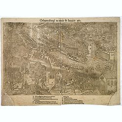
Orleans assiegé au mois de Janvier. 1563.
Rare copper engraved view of the siege of Orleans in January 1563, engraved by Jean Jacques Perrissin, (1536 - before 1611).Print from the suite "The Wars, Massacres...
- $100 / ≈ €87
Date: Geneva, ca. 1570
![[Cairo] Wahrhafftige Abcontrafehtung der Mechtigen und Vesten Statt Alkair.](/uploads/cache/48618-250x250.jpg)
[Cairo] Wahrhafftige Abcontrafehtung der Mechtigen und Vesten Statt Alkair.
Double page 16th century woodblock city plan of Cairo. Bird's-eye perspective with amazing detail of the buildings, gardens, temples, palaces, farms and markets. Includes...
Date: Basel, ca. 1570
![[Euboe].](/uploads/cache/41989-250x250.jpg)
[Euboe].
Woodcut Ptolemaic-style map by Sebastian Münster figuring Euboea Island, published in the edition of Strabo by Henri Petri in 1571."Strabonis rerum geographicarum&q...
Date: Basle, Henri Petri, 1571
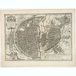
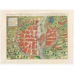
Lutetia, vulgari nomine Paris, urbs Gallia. . .
Beautiful and early town-plan of Paris with title cartouche and figures in the foreground. The Bastille is shown at the upper center of the engraving and the Notre-Dame c...
Date: Cologne, ca. 1572
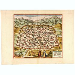
Damascus, urbs.
Early view of Damascus, a bird's eye view from the greatest publication in this genre ! The Civitates was compiled and written by George Braun, Canon of Cologne Cathedral...
- $750 / ≈ €649
Date: Cologne, 1572
Basiliensis territorii descriptio nova.
Left hand map centered on Basle, east to top. With credit to Sebastian Münster in title cartouche.
- $200 / ≈ €173
Date: Antwerp, 1573
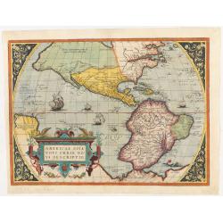
Americae Sive Novi Orbis, Nova Descriptio.
This is the second state of the first copperplate of Ortelius' map showing the western hemisphere, showing the prominent bulge in the South American coastline. The first,...
Date: Antwerp, 1573
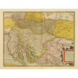
Illyricum.
Early map of Istria and Slovenia. Prepared by Johann Sambucus 1572.The map is in a strictly contemporary coloring.Read more about coloring.
- $400 / ≈ €346
Date: Antwerp, 1574
Die statt Montpellier . . .
Panoramic view of Montpellier by Sebastian Münster. Below the engraving a letterpress key. From the German edition of Sebastian Munster's Cosmography, "Cosmographey...
Date: Basel, Heinrich Petri, 1574
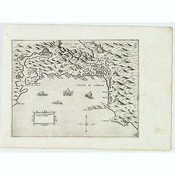
Golfo de Lodrin con parte di Albania.
Rare map of the northern coast of Albania, Serbia and Montenegro, extending from Malonta and Castel Novo and Bocca del Colfo di Cattaro to Durrës. Venetian war ships in ...
- $1500 / ≈ €1298
Date: Venice, D.Bertelli, ca.1574
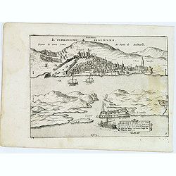
Sebenico antiquam.e Sico detto Citta nobile nella prouincia della Dalmacia. . .
Uncommon map of the coast of Croatia with the bay and town of Šibenik (Sebenico) with Venetian war ships in the foreground. From Giovanni Francesco Camocio's rare "...
- $1000 / ≈ €865
Date: Venice, D.Bertelli, ca.1574
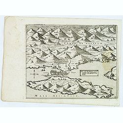
Trau citta nella Dalmacia vicino al Spaleto. . .
Uncommon map of the Dalmatian coast with the town of Trau (Trogir) in Croatia, from Giovanni Francesco Camocio's rare " Isole Famose porti, fortezze, e terre maritim...
- $1000 / ≈ €865
Date: Venice, D.Bertelli, ca.1574
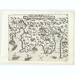
Provincia Di Albania.
Uncommon map of Albania, from Giovanni Francesco Camocio's rare " Isole Famose porti, fortezze, e terre maritime . . ." The second state, includes the plate n...
- $1200 / ≈ €1039
Date: Venice, D.Bertelli, ca.1574
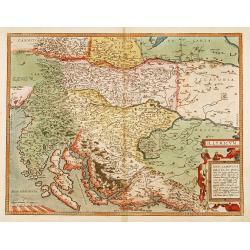
Illyricum.
Early map of Istria and Slovenia. Prepared by Johann Sambucus 1572.
Date: Antwerp, 1574
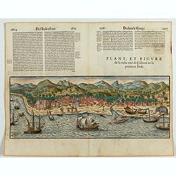
Plan, et figure de la riche cité de Calecut en la premiere Inde.
A rare and early woodcut view of Calcutta in India. Decorated with several ships on the sea, shipbuilding, fishermen and elephants.This woodcut was published in La Cosmog...
Date: Paris, 1575
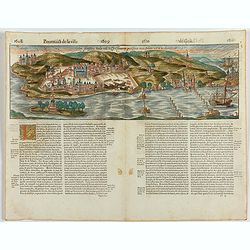
Goa fortissima Indiae urbs in Christianorum potestatem anno Salutis 1509. devenit.
A rare and early woodcut view of Goa in India. Decorated with one ship. This woodcut was published in La Cosmographie Universelle de tout le monde, printed in 1575 in two...
Date: Paris, 1575
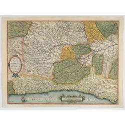
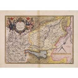
Pedemontanae Vicinorumque Regionum.
Fine map including the Italian coast from Monaco till Genoa. Milan in the upper righthand corner and Turin in the center of the map.
- $600 / ≈ €519
Date: Antwerp, 1574-1575
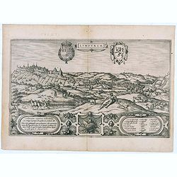
Lympurch. (Limburg)
Very desirable and early town-plan of the city of Limburg in Belgium with its fortifications at the end of the 16th century.From volume one of the greatest publication in...
- $250 / ≈ €216
Date: Cologne, 1575
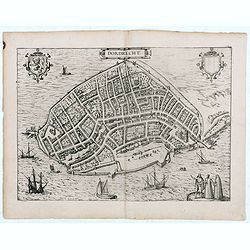
Dordrecht.
Very desirable and early town-plan of Dordrecht.From volume one of the greatest publication in this genre!. The Civitates was compiled and written by George Braun, Canon ...
- $200 / ≈ €173
Date: Cologne, 1575
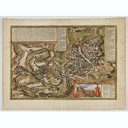
Hierosolymia, Clarissima totius Orientis civitas. . .
Two bird's eye perspectives on one sheet. The left plan shows ancient Jerusalem at the time of Christ. The view on the left also portrays the procession of Jesus to Golgo...
- $1200 / ≈ €1039
Date: Cologne, 1575
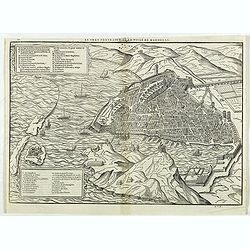
Le vray portraict de la Ville de Marseille.
Fine wood cut bird's-eye view of Marseille. Decorated with several ship in the harbour and on the sea. To the left two keys describing the main buildings and places. Publ...
Date: Paris, 1575
![[Figura del Mondo universale].](/uploads/cache/48963-250x250.jpg)
[Figura del Mondo universale].
Münster's map of the World is one of the most recognized world maps of the 16th Century. Italian text edition published in Cologne without the title. This example is fro...
Date: Arnold Birckmann heirs, Cologne, 1575
Title page from La Cosmographie Universelle..
In 1575 Sebastian Münster's Cosmographia was translated into French and published in Paris by François de Belle-Forest.
Date: Paris, 1575

Femina indica Orientalis - Indus Africanus - Singava vulgo dicta sive erratica femina Ori.
Beautiful engraving by Abraham de Bruyn showing inhabitants of Asian and African people with captions in Latin, French and German.Abraham de Bruyn, a Flemish engraver and...
Date: Cologne, c.1577
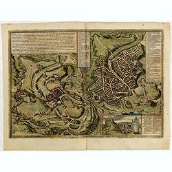
Messana, Urbs est Sicilie maxima, situ, opulentia, & tuta navium statione.
Very desirable and early town-plan of Messina on Sicily, with a numbered key (1-167) in lower part. "Messina is shown from the east, in a view looking down upon the ...
Date: Cologne, (1572) 1577
Leodium. (Luik or Liège)
Very desirable and early town-view of Liège, which shows the city with the Meuse flowing in its favorable location amongst gentle hills, sturdy trees and fertile fields....
- $300 / ≈ €260
Date: Cologne, (1572) 1577
![Sevilla, Hispalis ... [on sheet with] Cadiz [and] Malaga.](/uploads/cache/33642-250x250.jpg)
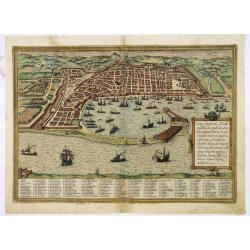
Sevilla, Hispalis ... [on sheet with] Cadiz [and] Malaga.
Very desirable and early view of Sevilla, Cadiz and Malaga, with the Roman and Moorish citadels on the hills in the background. "In the upper part Sevilla, showing ...
- $500 / ≈ €433
Date: Cologne, (1572) 1577
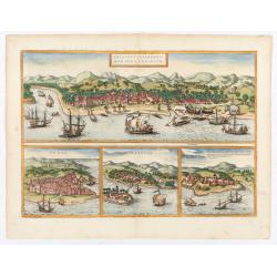
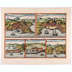
![Calechut Celeberrimum Indiae Emporium [on sheet with] Ormus [and] Canonor [and] S. Georgii Oppidum Mina.](/uploads/cache/41525-250x250.jpg)
Calechut Celeberrimum Indiae Emporium [on sheet with] Ormus [and] Canonor [and] S. Georgii Oppidum Mina.
Four desirable and early town plans of Kozhikode, Hormuz, Kannur, and Almina. "KOZHIKODE (CALICUT) : "The city is viewed from the sea, just as it would have ap...
- $800 / ≈ €692
Date: Cologne, (1572) 1577
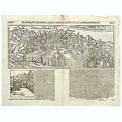
Die Statt Paris etlicher mass figuriert und contrafehtet nach jetziger Gelegenheit.
Published in the "Universal Cosmography" of S. Münster. Text in German. Under the legendary plan in German A to G. It is framed by a border composed of foliage...
- $200 / ≈ €173
Date: Bâle, H. Petri, 1578
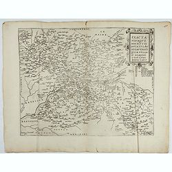
Exacta novaqve descriptio dvcatvs Andegravensis qvem vvlgari nomine Le Duche d'Aniou Indigitant.
Centered on the town of Angiers. From the first edition of De Jode's Speculum Orbis Terrarum, the second general atlas of the world, after Ortelius. Engraved by Ioannes V...
- $750 / ≈ €649
Date: Antwerp, 1578
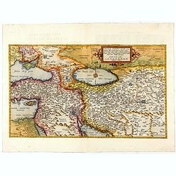
Primae Partis Asiae.
The Very Rare First State. Turkey/ Holy Land/ Iran/ Iraq/ Arabia/ Afghanistan. A superb example of the rare 1578 edition of this fine map of the Middle East, spanning fro...
- $4500 / ≈ €3895
Date: Antwerp, 1578
![[Paris] Die Statt Paris etlicher maß figuriert und contrafehret nach jetziger Gelegenheit.](/uploads/cache/49189-250x250.jpg)
[Paris] Die Statt Paris etlicher maß figuriert und contrafehret nach jetziger Gelegenheit.
Bird's-eye view of Paris. From a German text edition of S. Münster's Cosmographia, which is a short and complete summary of Renaissance knowledge. Text in German. Under ...
Date: Basle, 1550-1580
Calechut / Ormus / Canonor.
Four panoramic on one sheet: the upper approximately two-thirds of this double page sheet contains a fine panoramic view of Calicut which is on the west coast of India i...
Date: Cologne, 1580
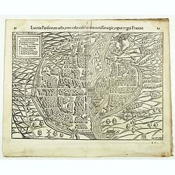
Lutetia Parisiorum urbs, toto orbe celeberrima notissimaque, caput regni Franciae.
Early bird's eye view of Paris, called at the time Lutetia. From a French text edition of S. Münster's Cosmographia, which is a short and complete summary of Renaissance...
Date: Basle, 1550-1580
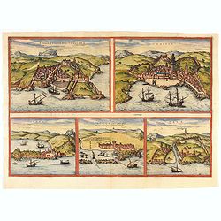
Tingis, Lusitanis, Tangiara. / Tzaffin. / Septa. / Arzilla/ Sala.
Views of the five northern and western African coastal town-view on one sheet: Latin text.From the greatest publication in this genre!. The Civitates was compiled and wri...
- $600 / ≈ €519
Date: Cologne, 1580
Jerusalem.
On verso an early representation of Jerusalem (102x79mm) and underneath a temple and a church.From a German text edition of his Cosmographia , that great compendium of Re...
Date: Basle, 1550-1580
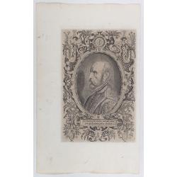
Spectandum dedit Ortelius mortalib..
This famous portrait, engraved by Galle, was included in Ortelius' atlases from 1579 onwards.The title translation is By looking, Ortelius gave to mortal beings the world...
- $550 / ≈ €476
Date: Antwerp, 1580
1) Caletensivm et Bononiensivm..2) Veromandvorvm eorvmque..
Prepared by Jean Surhon, cartographer, goldsmith and engraver. From 'Theatrum Orbis Terrarum [Atlas of the Whole World]': published in Antwerp.
- $200 / ≈ €173
Date: Antwerp, 1580
Moscavw. Moscovia, Urbs regionis eiusde nominis metropolitica, duplo maior. . .
Showing Moscow within the walled city and figures in the foreground. Title cartouche in the lower right corner Moscovia, Urbs. Regionis ciusde nominis metropolitica, dup...
Date: Cologne, 1580
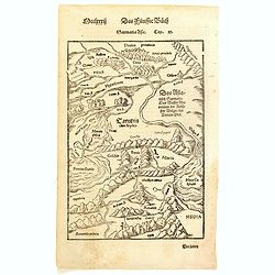
Sarmatia Asie.
The map is showing the area of Armenia and Kazakhstan. From his Cosmographia, that great compendium of Renaissance knowledge. Sebastian Münster was born in Nierder-Ingel...
- $90 / ≈ €78
Date: Basle, 1550-1580
Tingis, Lusitanis, Tangiara. / Tzaffin. / Septa. / Arzilla/ Sala.
Views of the five northern and western African coastal town-view on one sheet: Latin text.From the greatest publication in this genre!. The Civitates was compiled and wri...
Date: Cologne, 1580
Lutezia citta de Parigini celebratissima per tuto. . .
Very early birds-eye view of Paris. From his an Italian edition of his Cosmographia, that great compendium of Renaissance knowledge. An exciting print.Engraved by Hans Ru...
Date: Basle, 1550-1580
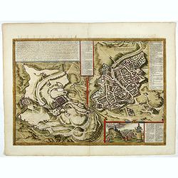
Hierosolymia, Clarissima totius Orientis civitas. . .
Two bird's eye perspectives on one sheet. The left plan shows ancient Jerusalem at the time of Christ. A contemporary view of Jerusalem appears to the right with an attra...
Date: Cologne, 1582
Hierosolymia, Clarissima totius Orientis civitas. . .
Two bird's eye perspectives on one sheet. The left plan shows ancient Jerusalem at the time of Christ.A contemporary view of Jerusalem appears to the right with an attrac...
- $1100 / ≈ €952
Date: Cologne, 1582
Turcici imperii descriptio.
Fine map of the Middle East, extending from Greece to Arabia and covering the Cradle of Civilisation region.Abraham Ortelius (1527-1598) was a cartographer and publisher ...
- $550 / ≈ €476
Date: Antwerp, 1583
Veronae Urbis Territorium.
Very fine map of part of Italy centered on Verona, Vizenza and Lake Garda. Prepared by Bernardino Brugnoli, which first was published in 1574 by Forlani. Ortelius' map is...
Date: Antwerp, 1584