Browse Listings

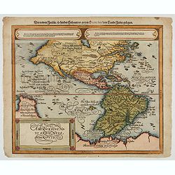
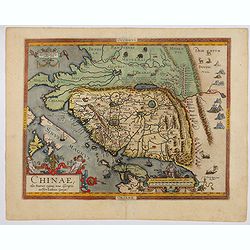
Chinae, olim Sinarum Regionis, nova descriptio. Auctore Ludovico Georgio.
The first map of China ever to appear in a Western atlas, west to the top. The first state without "las Philiooinas" somewhere in 1587 added to the plate. When ...
Date: Antwerp, 1584
![[Asia Minor]](/uploads/cache/35958-250x250.jpg)
[Asia Minor]
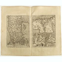
Early, attractive woodcut map of Turkey, with Cyprus shown in the lower right corner. On the full sheet with German text beneath and verso. From the German edition of Seb...
- $50 / ≈ €43
Date: Basle, 1584
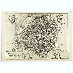
Veronae Urbis Territorium.
Very fine map of part of Italy centered on Verona, Vizenza and Lake Garda. Prepared by Bernardino Brugnoli, which first was published in 1574 by Forlani. Ortelius' map is...
Date: Antwerp, 1584
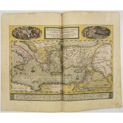
Peregrinationis Divi Pauli Typus..
A splendid map depicting the travels of Paulus. With two fine scenes in top. Showing the countries along the Mediterranean, including Cyprus and Italy. A first edition wi...
Date: Antwerp, 1584

Beschrijvinge vande de zee Cuften va Vlanderen en Picardien. . .
A detailed description of the coast of Picardie and Normandy decorated by a large colored baroque title cartouche, and the coat of arms of Flanders with a colorful scale ...
- $1750 / ≈ €1515
Date: Amsterdam, 1585
![Isarides suasu matris benedicitur, atque Efficitur foelix a genitore suo Gene[sis]](/uploads/cache/48558-250x250.jpg)
Isarides suasu matris benedicitur, atque Efficitur foelix a genitore suo Gene[sis]
A superb example of this illustration from the series of the Story of Joseph. A blind Isaac is blessing Jacob.Copper engraving published in " Thesaurus sacrarum hist...
Date: Antwerp, 1585
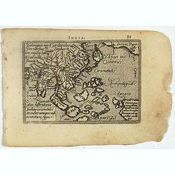
Indiae Orientalis, Insularumque Adiacentium Typus.
Map of Indonesia. From a French text edition of this illustrated treatise of geography, which is considered as the first modern pocket-atlas.Map engraved by Philip Galle....
- $500 / ≈ €433
Date: Antwerp, 1585
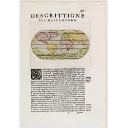
Descittione del Mappamondo.
A fine miniature oval map of the world engraved by Girolamo Porro. It is a reduction of Giovanni Francesco Camocio's superb large map of 1567, one of the last in the long...
- $450 / ≈ €389
Date: Venice, ca.1586
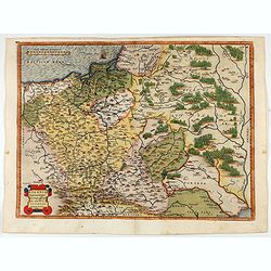
POLONIAE finitimarumque locorum descrip:tio. Auctore WENCESLAO GRODECCIO. Polono.
Ortelius' map of Poland, being a close copy of Grodecki / Pograbka's map of 1558/62 map, itself based on Wapovsky 1526 (Karrow 56) With Latin text on verso, a state 1 and...
- $1200 / ≈ €1039
Date: Antwerp, 1587
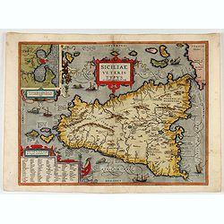
Siciliae Veteris Typus.
A very beautiful early map of ancient Sicily. Title cartouche centered on the upper part: includes also an inset map of Syracuse in the upper left, and a list of the town...
- $600 / ≈ €519
Date: Antwerp, 1587
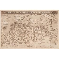
Barbariae et Biledulgerid, nova descriptio.
North-West Africa. Koeman speculated: In view of the important trading relationship between Antwerp and Africa, it is not impossible that the original was a manuscript ma...
- $300 / ≈ €260
Date: Antwerp, 1587

Natoliae.. Aegypti recentior.. Carthaginis ( 3 maps on 1 sheet)
Three maps on one sheet. Map to the left east to the top. Detailed map Turkey, including Cyprus and Crete. Also map of the Nile delta and another map of Tunis. From "...
- $750 / ≈ €649
Date: Antwerp, 1587
![[Asia Minor]](/uploads/cache/35969-250x250.jpg)
[Asia Minor]
Sebastien Münster's small map of Asia Minor, complete with a sea monster, bold rivers, mountains, forests and prominent cities of the region. German text below and to ve...
- $75 / ≈ €65
Date: Basle, 1588
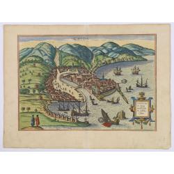
Chios.
The engraving shows the seaport of Chora, the capital of Chios, as seen from the east in a bird's-eye view.
Date: Cologne, ca 1588
Americae Sive Novi Orbis, Nova Descriptio
Woodcut map by based on Abraham Ortelius' classic map of 1570, with the huge bulge in the southwest coastline of South America, the Ortelian western coastline of North Am...
Date: Basel, ca. 1588
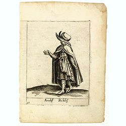
Arabs Nobilis.
Costume plate published by Pietro Bertelli in his "Diversarum nationum habitus", a sixteenth-century Italian costume book. The work was published with fold-out ...
- $70 / ≈ €61
Date: Padua, 1589
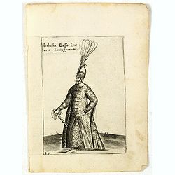
Bolucha Bassa Centurio Ianizerorum.
Costume plate published by Pietro Bertelli in his "Diversarum nationum habitus", a sixteenth-century Italian costume book. The work was published with fold-out ...
- $60 / ≈ €52
Date: Padua, 1589
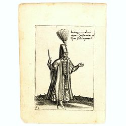
Ianizer excubias agens constantinapo lipro Aulu Imperatoris.
Costume plate published by Pietro Bertelli in his "Diversarum nationum habitus", a sixteenth-century Italian costume book. The work was published with fold-out ...
- $60 / ≈ €52
Date: Padua, 1589
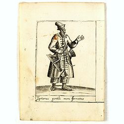
Tartarus gentili more Armatus.
Costume plate published by Pietro Bertelli in his "Diversarum nationum habitus", a sixteenth-century Italian costume book. The work was published with fold-out ...
- $60 / ≈ €52
Date: Padua, 1589
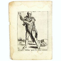
Monachi habitus guem Geruisium nominant.
Costume plate published by Pietro Bertelli in his "Diversarum nationum habitus", a sixteenth-century Italian costume book. The work was published with fold-out ...
- $50 / ≈ €43
Date: Padua, 1589
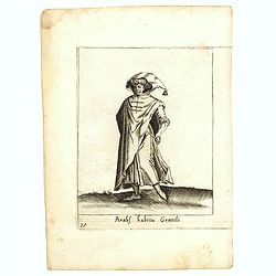
Arabs habitu Gentili.
Costume plate published by Pietro Bertelli in his "Diversarum nationum habitus", a sixteenth-century Italian costume book. The work was published with fold-out ...
- $50 / ≈ €43
Date: Padua, 1589
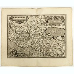
AFRICAE PROPRIAE TABULA In qua, Punica regna vides; Tyrios, et Agenoris / urbem.
AFRICAE PROPRIAE TABULA In qua, Punica regna vides; Tyrios, et Agenoris / urbem. Antique map of North Africa with Carthage. A very decorative map of North Africa wi...
- $350 / ≈ €303
Date: Antwerp, 1590
Valencena . . .
Eye-bird view of Valenciennes.
Date: Anvers, 1590
Picardiae Belgicae regionis descriptio
From Theatrum Orbis Terrarum [Atlas of the Whole World]. Prepared by Jean Surhon.Dare to go in Black. All early maps were printed in black and white, and many were kept t...
Date: Antwerp, 1590
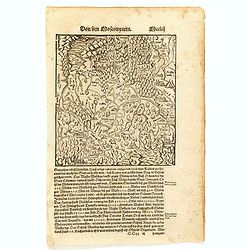
Von dem Moscowycern
Map centered on Moscow, with on verso a wood cut engraving of a Bison. From a German text edition of his Geographia , that great compendium of Renaissance knowledge.
- $125 / ≈ €108
Date: Basle, 1550-1590
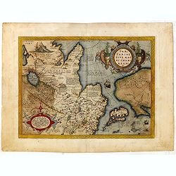
Tartariae sive Magni Chami Imperium.
This is a very early depiction of the northern Pacific, with the first mapping of the Northwest Coast of America and probably the first map to name California 'C. Califor...
- $1750 / ≈ €1515
Date: Antwerp, c. 1590
![[De terra sancta.]](/uploads/cache/32540-250x250.jpg)
[De terra sancta.]
On verso a map of the Middle East with Syria, Israel and Cyprus (123x158mm.). From a Latin text edition of his Geographia , that great compendium of Renaissance knowledge...
- $50 / ≈ €43
Date: Basle, 1550-1590
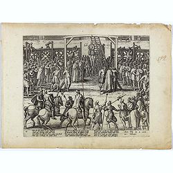
Wie ist das gluck so gar ungleich . . . Plate 18.
Early print showing a hanging in Brabant on 11 February 1620.Plate from the series about the " Eighty Years' War" or the independence war of Holland against Spa...
- $80 / ≈ €69
Date: Cologne, ca. 1590
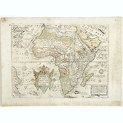
Africa ex magnae Orbis Terrae Descriptione.
Very rare separately published "Lafreri" map of Africa. The title in typical Italian scrollwork surmounted by two Cupids in the lower Atlantic. A dedication to ...
Date: Venice, ca. 1590
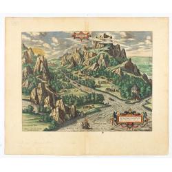
Tempe.
An attractive view of Mount Olympus and the valley in northern Thessaly (Greece), called the Vale of Tempe in ancient times, through which the river Peneus (present-day S...
Date: Antwerp, 1590

La Florida/ Peruviae Auriferae regionis Typus/ Guastecan.
The Chaves map of Florida is a prime example of an explorer's map since it records the recent discoveries of Cabeza de Vaca, De Soto, and Moscoso. The map revealed little...
- $1400 / ≈ €1212
Date: Antwerp, 1592
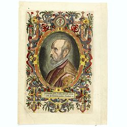
(Portrait of Abraham Ortelius)
The famous head and shoulder portrait of Ortelius aged 50, engraved by Philippe Galle, included in his atlas. famous cartographer born in Antwerp and, after studying Gree...
- $700 / ≈ €606
Date: Antwerp, 1592
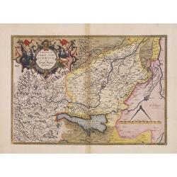
Chinae, olim Sinarum Regionis, nova descriptio. Auctore Ludovico Georgio.
The first map of China ever to appear in a Western atlas, west to the top. The second state with "Las Philipinas" somewhere in 1587 added to the plate. When thi...
- $6000 / ≈ €5193
Date: Antwerp, 1592

POLONIAE finitimarumque locorum descrip:tio. Auctore WENCESLAO GRODECCIO. Polono.
Ortelius' map of Poland, being a close copy of Grodecki / Pograbka's map of 1558/62 map, itself based on Wapovsky 1526 (Karrow 56) With Latin text on verso, a state 4 and...
- $1400 / ≈ €1212
Date: Antwerp, 1592
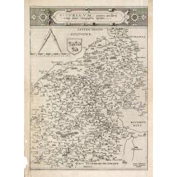
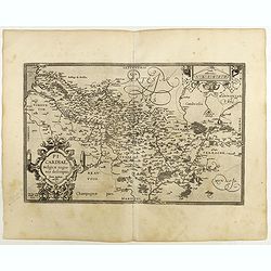
Bitvrigvm, provinciae que Berry.
A rare and beautifully engraved map from the second edition of De Jode's atlas "Speculum Orbis Terrarum". Includes the Loire Valley, centered on Bourges and Vie...
Date: Antwerp, 1593
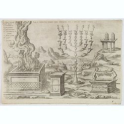
Sacri in tabernaculo apparatus partes ex descriptione Mosis. . .
Fine engraving of the brazen altar, bronze altar, or altar of sacrifice among other ritual objects such as the candelabrum. From Benedictus Arias Montanus' Antiquitatum I...
- $200 / ≈ €173
Date: Antwerp, 1572 / Leiden, 1593
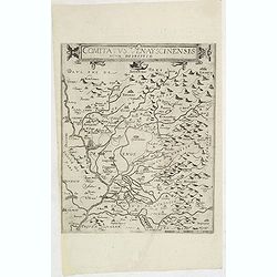
Comitatus Venayscinensis Nova Discriptio.
Rare map depicting part of Provence with Avignon, Cavaillon, Orange, Carpentras, etc.Gerard De Jode was the great rival of Ortelius, both made a living out of selling map...
- $325 / ≈ €281
Date: Antwerp, 1593

Prussiae Regionis Sarmatiae Europae Nobilissimae Novaet vera descriptio . . .
Nice example of the first edition of De Jode's map of Prussia, from the 1593 edition of De Jode's atlas.The present map is an entirely new addition to the second De Jode ...
- $2200 / ≈ €1904
Date: Antwerp, 1593
![Dritter Theil Indiae Orientalis . . . [Title page]](/uploads/cache/43482-250x250.jpg)
Dritter Theil Indiae Orientalis . . . [Title page]
A very attractive title page from the second part of de Bry's travel book. Theodore de Bry, a German engraver and book dealer, began a compilation of early voyages in 159...
- $250 / ≈ €216
Date: Frankfurt, 1594
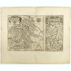
![Blaisois Blesiensis Territorii. . . [together with] - Lemovicum totius et confinium provinciarum. . .](/uploads/cache/28865-250x250.jpg)
Blaisois Blesiensis Territorii. . . [together with] - Lemovicum totius et confinium provinciarum. . .
The map on the left is centered on the Loire with the town of Blois. The right hand map is centered on Limoges.
- $150 / ≈ €130
Date: Antwerp, c. 1595
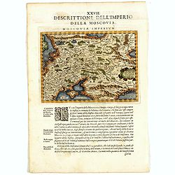
Descrittione Dell'Imperio della MOSCOVIA IMPERIUM.
Uncommon map including Latvia, Livonia, Lithuania, the Ukraine, and northern Part of the Black Sea and the Caspian Sea, Siberia, Georgia, Azerbaijan, Kazakhstan.Giovanni ...
Date: Venice, 1596

Calecuty Regnum
A rare and unusual depiction of the Indian Ocean between Madagascar, Ethiopia, southern Arabia, and south India and Ceylon.The calligraphy is florid and decorative. The e...
- $2000 / ≈ €1731
Date: Cologne, 1596
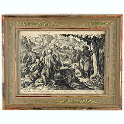
Sic capiunt Ibices iaculo, sic cuspide ferri, / Vel canibus, duro aut flammantis turbinis ictu.
A fine early illustration of capturing a mountain goat hunt. In the left foreground, a group of hunters rest, three dead mountain goats lying beside them; to the right, a...
- $300 / ≈ €260
Date: Antwerp, Philips Galle, ca 1596
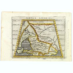
Tabula Asiae II.
A striking example of Magini's map of the Black Sea region from the 1597 edition of Magini's 'Geographia', based upon the work of Claudius Ptolemy. Latin text and tables ...
- $300 / ≈ €260
Date: Venice, 1597

Barbariae et Biledulgerid, nova descriptio.
North-West Africa. Koeman speculated: "In view of the important trading relationship between Antwerp and Africa, it is not impossible that the original was a manuscr...
Date: Antwerp, 1598
![Plants found in the island of S. Laurenti [Madagascar].](/uploads/cache/41368-250x250.jpg)
Plants found in the island of S. Laurenti [Madagascar].
‘ A’ denotes a tree with only a few twigs on the top. From this tree, canoes and boats are made. ‘B’ is a bush that the Dutch frequently encountered and was calle...
- $80 / ≈ €69
Date: Frankfurt, 1598
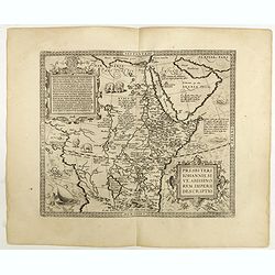
Presbiteri Johannis, sive Abissinorum Imperii descriptio.
Depicting Africa from the Mediterranean to the Mountains of the Moon placed just below Mozambique. Dare to go in Black. All early maps were printed in black and white,...
Date: Antwerp, 1598
Natoliae Quae Olim Asia Minor, Nova de Scriptio / Carthaginis Celeberrimi Sinus Typus / Aegypti re Centior de Scriptio
Three detailed regional maps by Ortelius from his "Theatrum Orbis Terrarum", the world's first modern atlas.The first map covers Asia Minor, Cyprus and the East...
Date: Antwerp, 1598
Terra Sancta A Petro Laicstain perlustrata, et ab eius ore
Oriented to the east. Shows the shoreline from Beirut to Gaza. P. Laicksteen, a Dutch astronomer… collected topographic material on Palestine during his stay there in 1...
Date: Antwerp, 1598

Romaniae, (quae olim Thracia dicta) ..
Very fine map centered on the Danube area. The map is based on the double sheet map by Jacob Gastaldi. Abraham Ortelius (1527-1598) was a cartographer and publisher, who ...
Date: Antwerp, 1598

Artois. Atrebatum Regionis Vera Descripto.
Prepared by Jacob Surhon, who made a manuscript map of Artois for which he received 36 Livres from Charles V in 1554. For security reasons, the map was not published. Onl...
Date: Antwerp, 1598
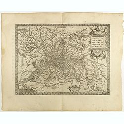
Regionis Biturigum... Per Ioannem Calamaeum. / Limaniae Topographia Gabriele Symeoneo Auct.
Two maps on one sheet. Biturigum. The Loire river is on the right in central France. Neuers (Nevers) is at the middle of the right margin. Bourges is near the center, and...
Date: Antwerp, 1598
![Blaisois Blesiensis Territorii. . . [together with] - Lemovicum totius et confinium provinciarum. . .](/uploads/cache/40963-250x250.jpg)
Blaisois Blesiensis Territorii. . . [together with] - Lemovicum totius et confinium provinciarum. . .
The map on the left is centered on the Loire with the town of Blois. The right-hand map is centered on Limoges. Dare to go in Black. All early maps were printed in bla...
Date: Antwerp, 1598
Anjou. Andegavensium Ditionis Vera et Integra Descriptio. Licimo Guijeto Andegavense auctore.
Beautiful map of the Anjou region of western France along the Loire River. Include the city of Angers in the center. Accompanying French text on verso. Dare to go in B...
Date: Antwerp, 1598
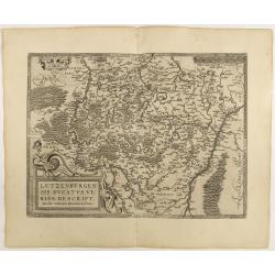
Lutzenburgen sis Ducatus Veriss. Descript.
An attractive map of Luxembourg: title cartouche on the lower left corner. From 'Theatrum Orbis Terrarum [Atlas of the Whole World]'.Iacobo Surhonio Montano auctore. D...
Date: Antwerp, 1598
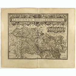
Leodiensis Diocesis Typus.
East to the top. Centered on Liege, including the southern part of Dutch Limburg. Prepared by Jan van Schille.Dare to go in Black. All early maps were printed in black an...
Date: Antwerp, 1598
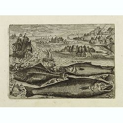
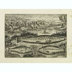
Pusser, Percainus, Salino. (Piscium Vivæ Icones - Fish)
Salmon and other fish set against a mountainous landscape in the manner of Pieter Brueghel the Elder. Plate number 11. The engraving is copied after Adrian Collaert plate...
- $200 / ≈ €173
Date: Antwerp, after 1598
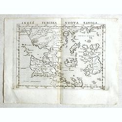
India Tercera Nuova Tavola.
Fine 1598 edition of this early map of South East Asia. Just to the west and south of Malacca, one will notice ‘Camatra’ (Sumatra) and Java. China with Canton in the ...
- $1000 / ≈ €865
Date: Venice, 1598
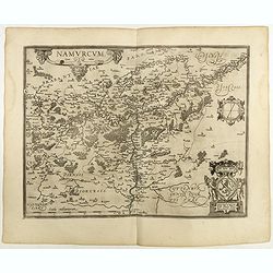
Namurcum Comitatus.
Prepared by Jacques Surhon in 1555. His manuscript map was, for security reasons not published. Only in 1579, when Antwerp was independent for a short time, Ortelius used...
Date: Antwerp, 1598
Perca, Tinca piscis. (Piscium Vivæ Icones - Fish)
Depiction of Perca, Tinca piscis. Fish types set against a mountainous landscape in the manner of Pieter Brueghel the Elder. Plate number 16. The engraving is copied afte...
- $200 / ≈ €173
Date: Antwerp, after 1598

Angliae, scotiae, et Hiberniae, sive Britannicar:insularum.
Fine general map of the British Isles and Ireland on horizontal projection with north to right of page. Derived from Mercator's 1564 map of the British Isles.Dare to go i...
Date: Anwerp, 1598

Angliae Regni florentissimi nova descriptio..
Fine general map of England derived from Mercator's 1564 map of the British Isles in 8 sheets.Dare to go in Black. All early maps were printed in black and white; many we...
Date: Antwerp, 1598
![Glissa. [Klissza or Klis]](/uploads/cache/45203-250x250.jpg)
Glissa. [Klissza or Klis]
Very rare view of Klissza (Klis) published in the first edition of "Viaggio da Venetia, a Costantinopoli. Per Mare, e per Terra, & infieme quello di Terra Santa....
- $300 / ≈ €260
Date: Venice, Giacomo Franco, 1598
Il theatro del mondo di Abraamo Ortelio…
Very rare first Italian edition issued in Brescia in 1598 by Pietro Marchetti. ; l theatro del mondo... Nel quale distinamenti si dimostrano in tavole tutte le provincie...
Date: Brescia (appresso la Compagnia Bresciana), 1598
Oswiec. et Zatorien. Ducatus.
Miniature map of Poland from "Il Theatro del Mondo," which was a plagiarized version of Ortelius' pocket atlas published specifically for the Italian market by ...
- $200 / ≈ €173
Date: Brescia, 1598
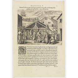
Argumentum I. Primus Lufitanorum cum Sogni praefecto congreffus, eiusdemque Baptismus, de quibus lib. 2 cap 2. fit mentio. (The arrival of the Portuguese in the county Sogno)
The arrival of the Portuguese in the county Sogno. When the Portuguese first discovered the county and the inhabitants of Sogno, they were taken for gods and received wit...
- $100 / ≈ €87
Date: Frankfurt, 1598
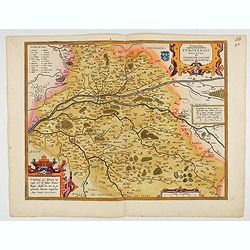
Touraine. Turonensis Ducatus.
Map of Touraine Duché in very fine original colours.
Date: Antwerp, 1598
![[View of Osero].](/uploads/cache/45194-250x250.jpg)
[View of Osero].
Very rare view of Osor published in the first edition of "Viaggio da Venetia, a Costantinopoli. Per Mare, e per Terra, & infieme quello di Terra Santa. Da Giosep...
- $400 / ≈ €346
Date: Venice, Giacomo Franco, 1598
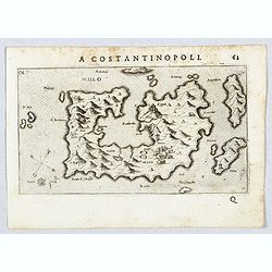
Millo.
Very rare view of Milos Island published in the first edition of "Viaggio da Venetia, a Costantinopoli. Per Mare, e per Terra, & infieme quello di Terra Santa. D...
- $450 / ≈ €389
Date: Venice, Giacomo Franco, 1598
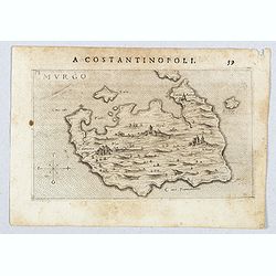
Murgo.
Very rare map of Amorgos published in the first edition of "Viaggio da Venetia, a Costantinopoli. Per Mare, e per Terra, & infieme quello di Terra Santa. Da Gios...
- $300 / ≈ €260
Date: Venice, Giacomo Franco, 1598
![Durazo [ view of Durres in Albania]](/uploads/cache/45212-250x250.jpg)
Durazo [ view of Durres in Albania]
Very rare view of Durres in Albania published in the first edition of "Viaggio da Venetia, a Costantinopoli. Per Mare, e per Terra, & infieme quello di Terra San...
- $450 / ≈ €389
Date: Venice, Giacomo Franco, 1598
![Dulcigno [Ulcinj in Montenegro]](/uploads/cache/45211-250x250.jpg)
Dulcigno [Ulcinj in Montenegro]
Very rare view of Ulcinj in Montenegro published in the first edition of "Viaggio da Venetia, a Costantinopoli. Per Mare, e per Terra, & infieme quello di Terra ...
- $450 / ≈ €389
Date: Venice, Giacomo Franco, 1598
![[ Map with part of Albania]](/uploads/cache/45210-250x250.jpg)
[ Map with part of Albania]
Very rare view of part of the coast of Albania published in the first edition of "Viaggio da Venetia, a Costantinopoli. Per Mare, e per Terra, & infieme quello d...
- $450 / ≈ €389
Date: Venice, Giacomo Franco, 1598
![Budova [Budua in Montenegro]](/uploads/cache/45209-250x250.jpg)
Budova [Budua in Montenegro]
Scarce map centered on Budua in Montenegro was published in the first edition of "Viaggio da Venetia, a Costantinopoli. Per Mare, e per Terra, & infieme quello d...
- $450 / ≈ €389
Date: Venice, Giacomo Franco, 1598
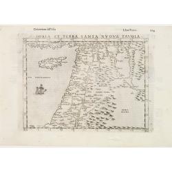
Soria et Terra Santa nuova tavola.
Early map of this classical map of the Holy Land, including Cyprus, prepared by Giovanni Botero. The copper plate was however later used by Giuseppe Rosaccio's expended e...
Date: Venice, 1598
Burgundiae inferioris quae Ducatus Nomine Censetur, Des.
Map centered on the province of Burgundy, from 'Theatrum Orbis Terrarum'.Dare to go in Black. All early maps were printed in black and white; many were kept that way for ...
- $100 / ≈ €87
Date: Antwerp, 1598
Braunsvicensis et Luneburgensis . . . (together with) Norimberg Agri,..
Two maps on one sheet, showing the regions of Braunschweig and Nuremberg from 'Theatrum Orbis Terrarum [Atlas of the Whole World]': published in Antwerp.Dare to go in Bla...
- $125 / ≈ €108
Date: Antwerp, 1598
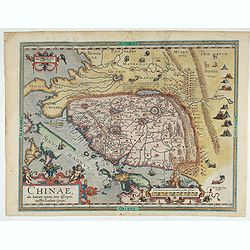
Chinae, olim Sinarum regionis. . .
The first printed map of China. It is signed by Ludovico Georgio, whose real name was Luis Jorge de Barbuda. He was a Portuguese Jesuit cartographer and besides that a sp...
Date: Antwerp, 1598
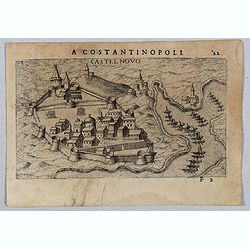
Castel Novo
Very rare view of Herceg-Novi, an important fortress belonging to Venetian Dalmatia captured during the 16th century by the Turks. Published in the first edition of "...
Date: Venice, Giacomo Franco, 1598
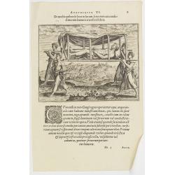
Argumentum VI. De modis quibus de loco in locum, feruorum aut conductitiorum humeris transferri Folent. (How the Congolese are transported)
How the Congolese are transported. None of the horses (probably zebras) are tame enough to ride and the people seem incapable of training the oxen to pull wagons for the ...
- $100 / ≈ €87
Date: Frankfurt, 1598