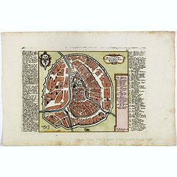
Browse Listings in Europe > Russia / Baltic / Black Sea region
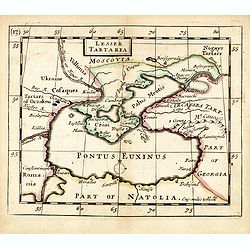
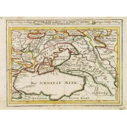
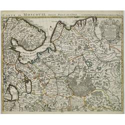
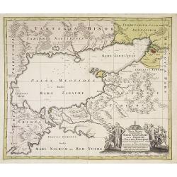
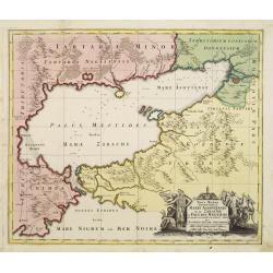
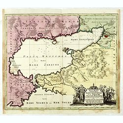
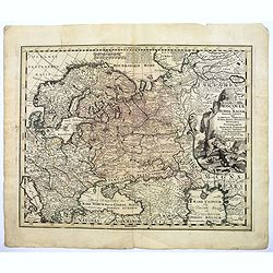
Lesser Tartaria.
A late seventeenth-century English map of the Crimea and southern Ukraine, with the whole of the Black Sea and its shores. A scarce little map utilized in various of the ...
- $300 / ≈ €262
Date: London, 1685
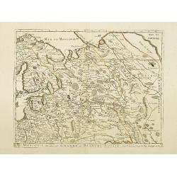
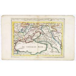
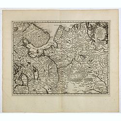
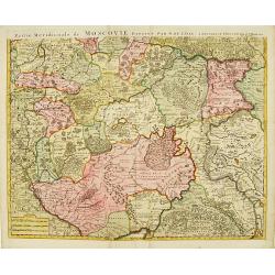
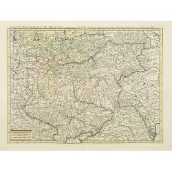
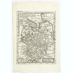
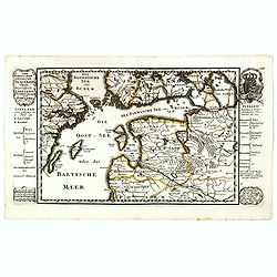
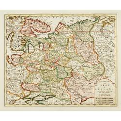
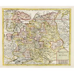
Moscovie dite autrement Grande et Blanche Russie.
Uncommon map of the Russia, including Finland, here with the date 1686.
Date: Paris, 1686
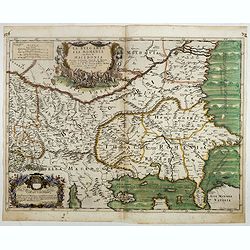
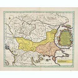
La Bulgaria ela Romania con Parte di Marcedonia. . .
Scarce map of the region along the Danube River and to the south. Extends to include part of the Sea of Azov and the northern extreme of the Aegean Sea. Elaborate militar...
- $600 / ≈ €524
Date: Rome, 1689
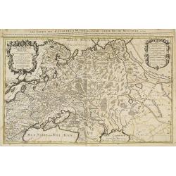
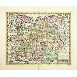
La Russie blanche ou moscovie. . .
Fine map of the European part of Russia with a decorative title and scale cartouche.Alexis-Hubert Jaillot (1632-1712), was a French cartographer. He joined the Sanson hei...
Date: Amsterdam, 1692
Moscovia Parte Occidentale. . . (with) ... parte orientale Delicata All Illustrissimo Signore Bartolomeo Sardi. . .
Uncommon two-sheet map of Russia extending north from the Caspian Sea to the east of the Gulf of Nova Zembla and the Cosack warriors in the southeast part of the map, all...
Date: Venice, 1695
Estats du Grand Duc de Moscovie . . .
An interesting small map of Moscovie by Nicolas de Fer. From his rare "Petit et Nouveau Atlas". The first edition was published in 1697 and was republished in 1...
Date: Paris, 1697
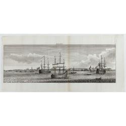
Archangel.
Decorative panoramic view of Archangel in Russia from "Reizen van Cornelis de Bruyn door de vermaardste Deelen van Klein Asia". Showing three large Dutch vessel...
- $300 / ≈ €262
Date: Amsterdam, 1698
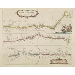
Dwina Fluvius.
Covens and Mortier's re-print of Joan Blaeu's map of 1662, first issued in the Atlas Maior. The course of the river from its source, a confluence in the Vologod Province ...
Date: Amsterdam, 1700
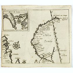
(Map of Nova Zembla with inset of Baye de Loms.)
Map of Nova Zembla with inset of Baye de Loms (5x7mm.). From the French reissue of the account of early Dutch voyages first published in 1608 by Commelin. The French tran...
- $110 / ≈ €96
Date: Amsterdam, E. Roger, 1702
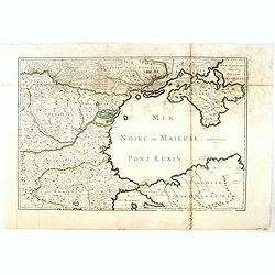
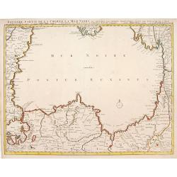
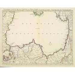
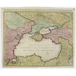
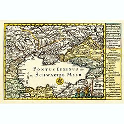
(Mer Noire ou Maieure, Pont Euxin.)
Very rare and detailed map of the Black Sea area prepared by Placide de Sainte-Hélène (1648-1734). and engraved by Claude-Auguste Berey (1651-1732).The map is of partic...
- $350 / ≈ €306
Date: Paris, 1703
Estats du Grand Duc de Moscovie.
Lovely small map of' Russia in Europe', extending from Poland and the Baltic in the west, Zembla in the frozen north, reaching down south to the Ukraine with Kiev and par...
- $150 / ≈ €131
Date: Paris, 1705
Carte de Moscovie dresseé par G.De L'Isle. . .
Detailed map of Russia centered on Moscow, including Lapland, prepared by de L'Isle and published in Amsterdam. With fine uncolored title cartouche.
- $375 / ≈ €328
Date: Paris, 1706
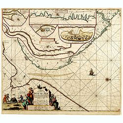
Paskaart van de Mont van de Witte Zee,. Beginnende van Tiepena tot Pelitza, als mede van C. Cindenoes tot Catsnoes.
Fine sea chart of the southern part of the Barents Sea, oriented to the West. With 5 inset maps: - Swetenoes, de Kust van Laplandt, Lombascho, "T Vaste Landt van Lap...
- $1000 / ≈ €874
Date: Amsterdam, c.1710
Carte marine de la mer Caspienne avec toutes ses Bayes Rivieres et Havres, dressée sur les observations des plus habiles Navigateurs,. . .
Strikingly engraved and attractive map of the Caspian Sea, showing major towns, ports, etc. Large decorative cartouche and compass rose.
- $500 / ≈ €437
Date: Leiden, 1710
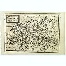
The Dominions of Moscovy or Russia.
A far reaching copperplate map of Russia by the Dutch emigrant Herman Moll. The map extends from Sweden in the west to Tartary and China in the east, to the south both th...
- $110 / ≈ €96
Date: London, 1711
Estats du Grand Duc de Moscovie ou de L'Empereur de la Russie Blanche. . .
The very rare first edition published by Antoine Menard in 1711 in "Le Nouveau et Curieux Atlas géographique et historique.". The map is more commonly found in...
- $500 / ≈ €437
Date: Paris, 1711
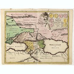
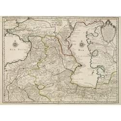
Assoph, Asow, oder Azak mit der Kleinen Tartarey dem Scwharzen Meer. . .
Scarce map showing the Black Sea region with Southern Ukraine, Georgia and Armenia.
- $100 / ≈ €87
Date: Augsburg, 1715
Assoph, Asow, oder Azak mit der Kleinen Tartarey dem Scwharzen Meer. . .
Scarce map showing the Black Sea region with Southern Ukraine, Georgia and Armenia.
- $300 / ≈ €262
Date: Augsburg, 1715
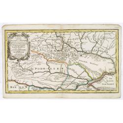
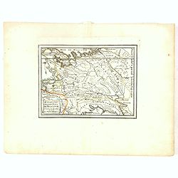
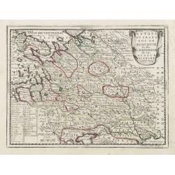
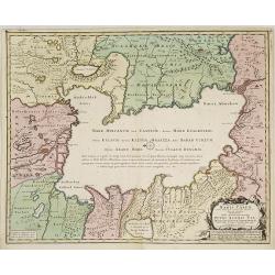
Die Gegend Zwischen Pultava und Bender Mitt Angraenzenden Polnisch, Turckisch und Tartarischen Landschafften.
Scarce map showing central part of the Ukraine with Bjelaja-Zerkow, Poltawa between the Dniester and Dnieper rivers. Black Sea in lower right corner. Detailed with notes,...
- $300 / ≈ €262
Date: Augsburg, 1715
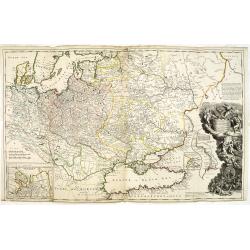
To His Most Serene and August Majesty Peter Alexovitz Absolute Lord of Russia &c. This map of Moscovy, Poland, Little Tartary, and ye Black Sea &c. is most Humbly Dedicated by H. Moll Geographer
Magnificent large-scale, English map of Russia, Ukraine, Poland, Finland and the Baltic Countries and extending south to the Black Sea and the Balkans, with an ornate ded...
Date: London, 1716

Les Rivieres Kur, et Aras.
View of Aras rivers after Cornelis de Bruyn, from "'Voyages de Corneille le Brun par la Moscovie, en Perse et aux Indes Orientales ...', by Corneille le Brun (Cornel...
- $75 / ≈ €66
Date: Amsterdam, Wetstein, 1718
La Moscovie meridionale . . .
Decorative map centred on Moscow. This well executed engraving was published in 1729 and 1727 by Pieter van der AA, in Leiden in "Les Voyages tres-curieux et tres-re...
- $300 / ≈ €262
Date: Leiden, 1719
Estats du Grand Duc de Moscovie ou de L'Empereur de la Russie Blanche. . .
Lovely small map of central Russia with decorative title cartouche and a panel in the lower left corner listing local rulers.From Le Nouveau et Curieux Atlas Geographique...
- $150 / ≈ €131
Date: Paris, 1719
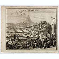
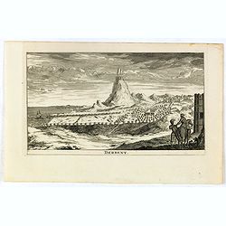
La ville de Berbendt, en Perse.
Decorative view of Derbendt - Derbent, a city in the Republic of Dagestan, Russia, located on the Caspian Sea, north of the Azerbaijani border. It is the southernmost cit...
- $350 / ≈ €306
Date: Leiden, 1719
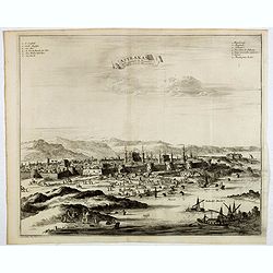
Astrakan, ville capitale du royaume du meme nom, en Moscovie. (Astrakhan)
Decorative view of Astrakhan. Astrakhan is where Europe ends and Central Asia begins. Its position on the Caspian Sea has ensured a long history as an important trading h...
- $300 / ≈ €262
Date: Leiden, 1719
La Moscovie septentrionale . . .
Decorative view of area north of Moscow. This well-executed engraving was published in 1729 and 1727 by Pieter van der AA, in Leiden in "Les Voyages tres-curieux et ...
- $250 / ≈ €218
Date: Leiden, 1719
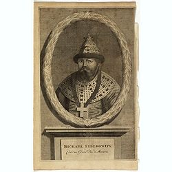
Michael Federowits . . .
Portrait of Tsar Michail Feodorovich (1596-1645). Engraving by Jacob Christopher Sartorius (1694-1737) engraver, active in Nuremberg. This well executed engraving was pub...
- $75 / ≈ €66
Date: Leiden, 1719
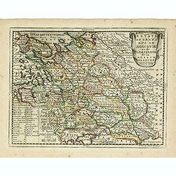
Estats du Grand Duc de Moscovie ou de L'Empereur de la Russie Blanche. . .
Lovely small map of central Russia with decorative title cartouche and a panel in the lower left corner listing local rulers.From Le Nouveau et Curieux Atlas Geographique...
- $150 / ≈ €131
Date: Paris, 1719
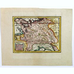
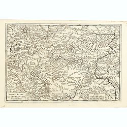
Partie Meridionale de Moscovie. . .
Centered on Moscow including Azow and part of present-day Ukraine in the bottom part of the map. The map is based on Delisle's important map of the region with revisions ...
- $200 / ≈ €175
Date: Amsterdam, 1720
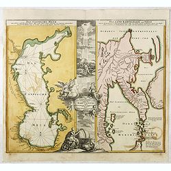
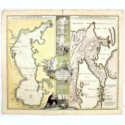
Das Caspische Meer / Das Land Kamtzadalie ...
Two maps on one sheet with the Caspian Sea on one side and northeastern Russia and Kamchatka on the other. The map of the Caspian Sea reflects the survey work of Russia�...
- $450 / ≈ €393
Date: Nuremberg, 1720
Seconde partie de la Crimee la Mer Noire. . .
The lower part of a set of two maps from the observations of Guillaume Delisle focuses on the Black Sea with wonderful detail of the surrounding regions. Includes Constan...
- $500 / ≈ €437
Date: Amsterdam, 1720
Nova ac verissima Maris Caspii ante hac maximam fere partem nobis incogniti, ac Regionum adiacentium : Delineatio Iussu Invictissimi Principis Petri Alexii Fil. Magni Russorum Imperatoris / immenso labore et maximis sumptibus facta, atque ex ...
Covers portions of Iran, Turkmenistan, Kazakhstan, Russia and Azerbaijan. Relief is shown pictorially. Depth is shown by soundings. Oriented with north to the left. Rare.
- $750 / ≈ €655
Date: Amsterdam, 1720
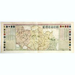
Carte du gouvernement civil ecclésiastique de moscovie, l'état des revenus et l'ordre de la justice et des officiers de la cour.
Interesting sheet with a detailed plan of Moscow, plus two large coats-of-arms, with descriptive French text, from Chatelain's monumental 7 volume Atlas Historique. In up...
- $950 / ≈ €830
Date: Amsterdam, 1720
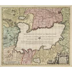
Asia intra Maeotim Pontum et Mare Caspium. . .
Striking map the Black Sea and Caspian Sea regions, featuring the geographical features known to the ancients and decorated with a vignette and 10 medallions.From "D...
- $195 / ≈ €170
Date: Nuremberg, 1720
Carte des Pays voisins de la Mer Caspiene. . .
A most attractive and detailed map of the region between the Black and Caspian Seas after De L'Isle. The two Seas are decorated with compass roses. This is one of the few...
Date: Amsterdam, 1720
Carte generale des Etats du Czar. Empereur de Moscovie, ou L'on voit ce que ce prince possede en Europe ..
Impressive map of Russia Tartary and part of China with key tables to the towns. Depicting the different states belonging to the Czar in Asia and Europe, showing the path...
- $900 / ≈ €786
Date: Amsterdam, ca. 1720
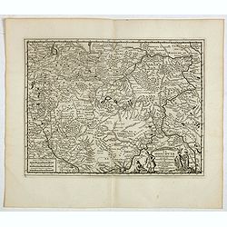
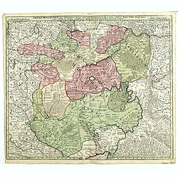
Illyricum Orientis In quo Partes II. Moesia et Thracia. Provinciae XI.
Attractive historical map of the area west of the Black Sea, today's Bulgaria, Rumania, etc. Based on the cartography of Nicolas Sanson and published by Covens and Mortie...
Date: Amsterdam, c. 1720
Partie Meridionale de Moscovie..
Centered on Moscow, including Azow in the bottom part of the map.The Amsterdam publishing firm of Covens and Mortier (1721 - c. 1862) was the successor to the extensive p...
- $300 / ≈ €262
Date: Amsterdam 1720
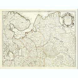
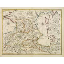
Russiae vulgo Moscovia dictae, Partes Septentrionalis. . .
In the north the Murmansk Sea. Including the western coast of Nova Zembla. Title cartouche and two cartouches, the bottom right one showing two hunters, bears, stags etc....
Date: Amsterdam, 1720
Carte de Moscovie. . .
Centred on Moscow, including Lapland. With fine uncolored title cartouche.
Date: Amsterdam, 1720
Ducatuum Livoniae et Curlandiae cum vicinis Insulis Nova Exhibitio Geographica. . .
Detailed map of the northern Baltic coast by Homann, pre-dating the privilege.
Date: Nüremberg, 1720
Partie Meridionale de Moscovie. . .
Scarce map centered on Moscow including Azow and part of present-day Ukraine in the bottom part of the map. The map is based on Delisle's important map of the region with...
- $750 / ≈ €655
Date: Amsterdam, 1720
Maris Assoviensis vel de Zabache et Paludis Maeotidis. . .
A very detailed map showing the Black Sea, Azow and Rostow area. With a decorative allegorical cartouche, showing the costumes of the indigenous people of the region.
Date: Augsburg, 1720
Maris Assoviensis vel de Zabache et Paludis Maeotidis. . .
A very detailed map showing the Black Sea, Azow and Rostow area.
Date: Augsburg, 1720
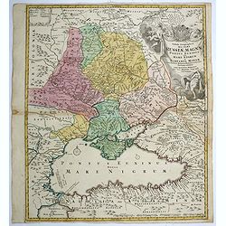
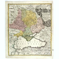
Tabula geographica qua pars Russiae Magnae..
A detailed map of western Russia, depicting the Ukraine, the Black sea, Turkey to the south, Romania and Bulgaria to the south west, Georgia to the east. Shows the cities...
Date: Nuremberg, 1720
Seconde partie de la Crimee la Mer Noire. . .
The lower part of a set of two maps from the observations of Guillaume Delisle focusing on the Black Sea with wonderful detail of the surrounding regions. Includes Consta...
- $750 / ≈ €655
Date: Amsterdam, 1720

Tabula geographica Russiae Magnae pontus euxinus seu mare nigrum et tauriae regnum. . .
Decorative map of the Black Sea Region, with a large decorative cartouche. Shows Constantinople. Extends north to Moscow and Smolensko.
Date: Nuremberg, 1720
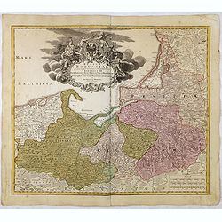
Regnum Borussiae gloriosis auspicijs Seerenissimi et Potentissimi Princip Friderici III Primi . . .
Map covering the region along the Baltic Sea from Prussia, Memel, to northern Poland, extending south to Poland, centered on Danzig, Konigsberg, Heilsperg, etc. Beautiful...
Date: Nuremberg, 1720
Tabula Geographica qua pars Russiae Magnae. . .
Homann's map is based upon Beauplan's general map of Ukraine but depicts the political changes of the preceding years. With decorative cartouches. Giving good detail alon...
Date: Nuremberg, 1720
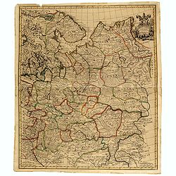
Moscovey in Europe from the latest Observations . . .
Fine, highly detailed map of the regions of European Russia by John Senex. Each region is depicted in original outline color, and a small decorative cartouche is in the t...
- $450 / ≈ €393
Date: London, 1721
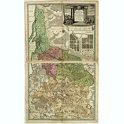
![[Set of 2 maps of Caspian Sea.] Carte marine de la Mer Caspiene. Levee suivant les ordres de S.M. Czariene, P](/uploads/cache/20009-250x250.jpg)
[Set of 2 maps of Caspian Sea.] Carte marine de la Mer Caspiene. Levee suivant les ordres de S.M. Czariene, P
Guillaume de l' Isle (1675-1724), Royal Geographer, was the most influential cartographer of the first quarter of the 18th century. ' Atlas de Géographie' (1700-12), pos...
- $350 / ≈ €306
Date: 1721
Carte des Pays Voisins de la Mer Caspiene dressee pour l' usage du Roy. . .
The map shows the area east of the Caspian Sea, including parts of Kazakhstan, Turkmenistan, Uzbekistan, and northern Iran. The area eastward from the Caspian is marked '...
- $750 / ≈ €655
Date: Paris, 1723
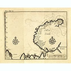
(Map of Nova Zembla with inset of Baye de Loms.)
Map of Nova Zembla with inset of Baye de Loms (5x7mm.).From the French reissue of the account of early Dutch voyages first published in 1608 by Commelin. The French trans...
- $100 / ≈ €87
Date: Amsterdam, F. Bernard, 1725
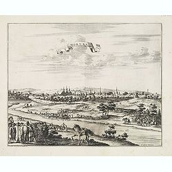
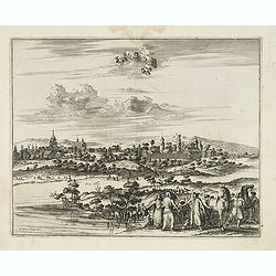
Moruma ville de la Tartarie Moscovite.
Decorative view of the town of Moruma, Russian city near the northern shore of the Caspian sea as seen from across the river Oka. This well executed engraving was publish...
Date: Leiden, 1719-1727
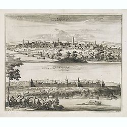
Soratof, ville de Tartarie Moscovite. / Tzornogar, Petite Ville des Moscovites, dans le Royaume d'Astracan, sur le bord du Volga.
Decorative engraving of two panoramic views in top Saratov with in the foreground the Volga River and in bottom a view of Chernyy Yar on the Volga River. This well execut...
Date: Leiden, 1719-1727
Cassimogorod ville de la Tartarie Moscovite.
Decorative view of the town of Kasimov on the Oka River, east from Moscow and south from Murom near the northern shore of the Caspian Sea. The city is seen from across th...
Date: Leiden, 1719-1727
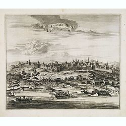
Zariza, petite ville des Moscovites, dans le royaume d'astracan, sur le bord du Wolga.
Decorative view of the town of Volgograd (Zarizyn) on the Volga River. This well executed engraving was published in 1729 and 1727 by Pieter van der AA, in Leiden in &quo...
Date: Leiden, 1719-1727
A Chart of the Sound -- A Map of the rivers Elbe and Weser -- The River Dvina and the harbour of Archangel.
Scarce sea chart by John Harris (1667?-1719) and James Knapton (d. 1738). Chart 20 from "Atlas maritimus & commercialis", shows Lapland and part of the Russ...
- $400 / ≈ €349
Date: London, J. Knapton, 1728
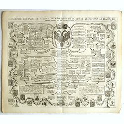
Généalogie des Cazrs de Moscovie ou empereurs de la grande Russie . . .
Genealogical tree, showing the lineage of the Russian Czar's, dating back to 840 according to Hubner. Published by Henri Abraham Chatelain (1684 – 1743) a Huguenot past...
- $250 / ≈ €218
Date: Amsterdam, 1728
Russia or Moscovy with its Acquisitions &c.
Herman Moll's map of western Russia, or Muscovy, published in London during the first half of the eighteenth century. It shows the newly acquires lands taken from Sweden ...
Date: London, 1729
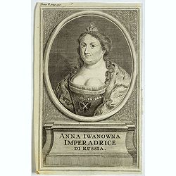
Anna Iwanowna Imperadrice di Russia.
Portrait of Anna Iwanowna (1693 – 1740), was regent of the duchy of Courland from 1711 until 1730 and then ruled as Empress of Russia from 1730 to 1740.
- $75 / ≈ €66
Date: France, ca. 1730
Nova Mappa Geographica Maris Assoviensis Vel De Zabache Et Paludis Maeotidis accurate aeri incis et in luce edita . . .
Striking map of the Sea of Azov with adjacent countries and the Strait of Kerch, with a decorative allegorical cartouche, showing the costumes of the indigenous people of...
Date: Augsburg, 1730
Moscow des Grossen Zaars Residenz.
A detailed plan of Moscow with an extensive description of the town and a numbered key 1-49 identifying important places. A coat of arms in the left corner.Afterwards, t...
- $400 / ≈ €349
Date: Augsburg, 1730
Der Nordischen Königreiche Süd=Oost Theil begreiffende Liefland Ingermanland und Finnland zum Theil.
Uncommon map published by Gabriel Bodenehr, who bought the Stridbeck copper plates in 1716, and continued publishing the Stridbeck Atlas: "Atlas Curieux," under...
- $400 / ≈ €349
Date: Augsburg, 1730
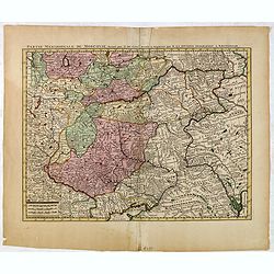
Imperii Moscovitici pars Australis.
A detailed map of the region around Moscow. Including the Ukraine and Cossack regions, to the west is Russian Poland and Lithuania, to the east Russian Tartary and Siberi...
- $500 / ≈ €437
Date: Augsburg, 1730
Nouvelle Carte de la Petite Tartarie et la Mer Noire, montrant les Frontieres de l'Impératrice de Russie et de l'Empereur des Turcs, tant en Europe qu'en Asie, Dessigné selon la proposition de G. De L'Isle et d'autres Auteurs.
The Ukraine and the Black Sea in a fine impression with original 18th-c. hand-coloring.
- $1250 / ≈ €1092
Date: Amsterdam, 1730
Geographica Nova ex Oriente gratiosissima, duabus tabulis specialissimis contenta, quarum una Mare Caspium..
Map of the Caspian Sea and the peninsula of Kamchatka (Jedso) in northeast Asia on one sheet.Separated by an attractive panel with figurative title cartouche, cherubs, an...
Date: Nuremberg, 1730
Nieuwe Kaart van Muskovie of Rusland.
Detailed map of European Russia, far south to the Black Sea and Caspian Sea. Isaac Tirion was born in Utrecht ca. 1705. He came to Amsterdam ca. 1725. Tirion published a ...
- $150 / ≈ €131
Date: Amsterdam, 1734
Derbent.
View of Derbent, the southernmost city in Russia from a scarce series of city views by Daniel de la Feuille (1640-1709). Engraving shows the ancient fortress and ruins of...
- $100 / ≈ €87
Date: Amsterdam, 1734
Nieuwe Kaart van Muskovie of Rusland..
Detailed map of European Russia, far south to the Black Sea and Caspian Sea. Isaac Tirion was born in Utrecht ca. 1705. He came to Amsterdam ca. 1725. Tirion published a ...
Date: Amsterdam, 1734
Nieuwe kaart van Muskovien door M. de l'Isle.
This lovely little map of the area surrounding Moscow is based on Delisle's map of the region. The map is bounded by Lake Ilmen in the north, the Volga River to the east,...
- $100 / ≈ €87
Date: Amsterdam, 1735
Potentissimo Borussorum Regi Friderico Wilhelmo Maiestate, Fortitudine Clementia Augustissimo Hancce Lithuaniam Borussicam : in qua luca coloniis Salisburg., ad incolendum Regio nutu concessa ...
Potentissimo Borussorum Regi Friderico Wilhelmo Maiestate, Fortitudine Clementia Augustissimo Hancce Lithuaniam Borussicam : in qua luca coloniis Salisburg., ad incolendu...
- $1200 / ≈ €1048
Date: Nuremberg, 1735
Potentissimo Borussorum Regi Friderico Wilhelmo Maiestate, Fortitudine Clementia Augustissimo Hancce Lithuaniam Borussicam : in qua luca coloniis Salisburg., ad incolendum Regio nutu concessa ...
Potentissimo Borussorum Regi Friderico Wilhelmo Maiestate, Fortitudine Clementia Augustissimo Hancce Lithuaniam Borussicam : in qua luca coloniis Salisburg., ad incolendu...
- $1500 / ≈ €1310
Date: Nuremberg, 1735
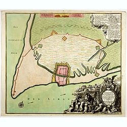
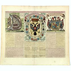
Ichnographia munitissimae Arcis Otzakoff quae Ao. 1737, die 3 Iulÿ auspicÿs Supremi Campi Mareschalli Comitis de Münnich ab exercitu Russorum vi occupata . . .
A striking image of this fortified Russian outpost on the Black Sea at Otzakoff, northeast of Odessa.
- $1100 / ≈ €961
Date: Augsburg, 1737
Nova et accuratissima Maris Caspii. . .
Original hand colored copper engraving of Matthaeus Seutter. Showing the Caspian Sea with the large Volga Delta in east orientation. Main towns / countries around the Cas...
- $750 / ≈ €655
Date: Augsburg, 1740
Moscoviae seu Russiae Magnae Generalis Tabula. . .
A scarce and attractive, wide-ranging map of incorporating Scandinavia, the Baltic countries, parts of Germany and Czechoslovakia, Poland, Hungary, Ukraine, Bulgaria, Nor...
- $1500 / ≈ €1310
Date: Augsburg, 1740
Moscovia o Russia.
Map showing European Russia and is centered on Moscow. In the lower right corner, title cartouche with scale and the town of Astrakhan. From "Atlante Novissimo Che C...
Date: Venice, 1740
Die Europaeische oder kleine Tartarey, nebst den angraentzenden Laendern. . .
Showing the Black Sea region. Uncommon map from the "Atlas Selectus" by the German cartographer Johann Georg Schreiber (1676-1750). Schreiber followed in the fo...
- $450 / ≈ €393
Date: Leipzig, 1741
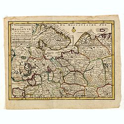
'T Noorderdeel van Moscovie Na de stelling van G. de L'Isle. . .
Attractive and rare map of part of Russia, including St. Persburg, Archangel, Finland, Lapland and Moscow. From Atlas Portatif .
- $100 / ≈ €87
Date: Deventer, 1742
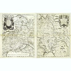
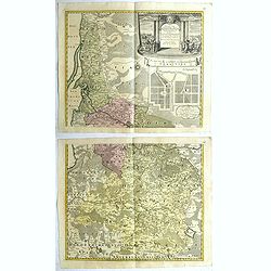
![[2 maps and one text sheet] Theatrum Belli A° MDCCXXXVII. . . / Verus Chersonesi Tauricae Seu Crimea Conspectus adjacentium item Regionem itinerisq ab Exercitu Ruthemo...](/uploads/cache/27975-250x250.jpg)
[2 maps and one text sheet] Theatrum Belli A° MDCCXXXVII. . . / Verus Chersonesi Tauricae Seu Crimea Conspectus adjacentium item Regionem itinerisq ab Exercitu Ruthemo...
[2 maps and one text sheet] Theatrum Belli A° MDCCXXXVII. . . / Verus Chersonesi Tauricae Seu Crimea Conspectus adjacentium item Regionem itinerisq ab Exercitu Ruthemo A...
- $1100 / ≈ €961
Date: Amsterdam, c. 1744
