Browse Listings in Europe > Russia / Baltic / Black Sea region
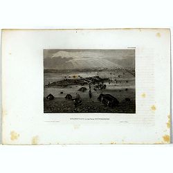
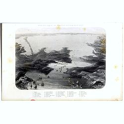
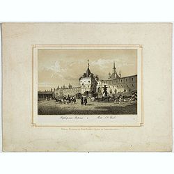
Kronstadt, in der ferne Petersburg.
Bird's eye view of Kronstadt, Russia's naval basis in front of Saint Petersburg. Original steel engraving published by Bibliographisches Institut Hildburghausen.
- $15 / ≈ €13
Date: Hildburghausen, ca. 1860
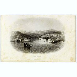
Sebastopol.
Steel engraving of the harbour at Sebastopol in the Ukraine published by James Virtue around 1860.
- $45 / ≈ €39
Date: London, 1860
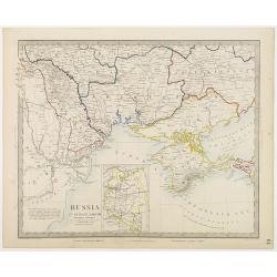
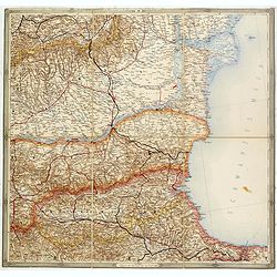
Russia in Europe Part VIII with index map.
Very detailed steel engraved map of the region north of the Black Sea, Podolia, Bessarabia, Kherson, Iekaterinoslav, Taurida, Krimea. Relief shown by hachures.The map is ...
- $150 / ≈ €131
Date: London, Edward Stanford, 1864
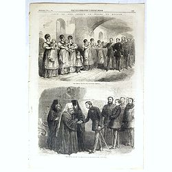
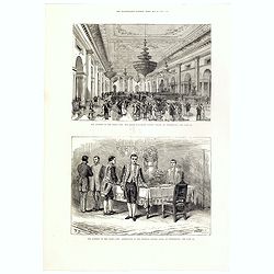
The Prince visiting the foundling hospital. / The Prince visiting the Metropolitan Archbishop.
Two engravings shown Albert Edward the Prince of Wales visiting Moscow from the Illustrated London News.
- $10 / ≈ €9
Date: London, 1866
Birds-eye view of the Straits of Kertch & Sea of Azoff.
Steel engraving of the harbour at Sebastopol and the Straits of Kertch and Sea of Azoff in the Ukraine published by James Virtue around 1860.Title in upper margin. With a...
- $75 / ≈ €66
Date: London, 1870
(Untitled map of western shores of the Black Sea, with Bulgaria, Roumenia.)
Untitled map of western shores of the Black Sea, with Bulgaria, Roumenia. The map has elaborate floral borders. Prepared by Josef Schlacher in Vienna and published by K.K...
- $150 / ≈ €131
Date: Vienna, K.K. Militär Geografisches Institut, 1875
![[Schwarzes Meer] Nr 1](/uploads/cache/37946-250x250.jpg)
[Schwarzes Meer] Nr 1
Uncommon map of the Black Sea and Crimea. In lower part a scale. Prepared by Friedrich Handtke (1815-1879). Map set in a decorative border.
- $120 / ≈ €105
Date: Glogau, Leipzig, 1877
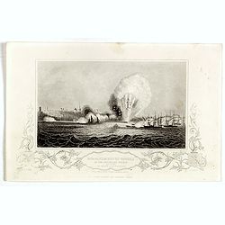
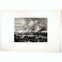
Bombardment of Odessa by the English and French April 22 1854, explosion on the imperial mole . . .
Scene from the Crimea war, showing a bombardment of Odessa, 22nd April 1854 (during Crimean War, 1853-56), by English and French forces, explosion imperial mole (breakwat...
- $30 / ≈ €26
Date: London, ca. 1879

The attempt on the Czar's life: the Soltykoff dorway of the Winter Palace . . .
A panorama of the Winter Palace published in the Illustrated London News of 1880.
- $20 / ≈ €17
Date: London, 28 February, 1880
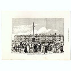
The attempt on the Czar's life: The Winter Palace, St Petersburg.
A panorama of the Winter Palace with an attempt on the Czar's life published in the Illustrated London News of 28 February, 1880.
- $15 / ≈ €13
Date: London, 28 February, 1880
The attempt on the Czar's life: The Grand Ball-Room . . .
A panorama of the Winter Palace with an attempt on the Czar's life published in the Illustrated London News of 28 February, 1880.
- $15 / ≈ €13
Date: London, 28 February, 1880
Porte Ste Barbe.
View of the gate of St. Barbe. Title in Russian and French.
- $50 / ≈ €44
Date: Russia, ca. 1880
Bataille de la Moskova.
Etching of a battle in which Napoleon's army fought the Russian army of general Kutuzov on 7 September 1812.Etched by Auguste II. Boulard (1852–1927) after a painting b...
- $50 / ≈ €44
Date: Paris, 1880
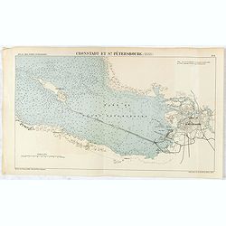
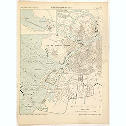
Cronstadt et St. Petersbourg.
Detailed plan of the port and city of St. Petersburg including Kotlin Island and the fortified town of Kronstadt.
- $35 / ≈ €31
Date: Paris, 1888
St. Pétersbourg (1888).
Map of St. Petersburg from a French multi volume atlas published by the Ministere des Travaux Publics (Ministry of Civil Engineering), called "Atlas des ports étran...
- $120 / ≈ €105
Date: ?Paris, Imprimerie Nationale 1884-1889
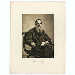
Léon Tolstoy.
Etching by Gustaf Frank after a painting of Ilya Repin (1887). Gustav Frank (1859-1923) attended school in Vlasim, where he learned to draw from Cenka Schneider. Then he ...
- $50 / ≈ €44
Date: Vienna, 1900
![[Map of Grodno gubernia.]](/uploads/cache/81813-250x250.jpg)
[Map of Grodno gubernia.]
Карта Гродненско&...
- $450 / ≈ €393
Date: Sankt Peterburg, 1850-1900

Excelsiori (Rana N. 28 - Cent. 20).
"After so many wars and so many troubles, young Russia, in a more serene glaze all the beautiful sun of freedom you will enjoy ... ". Fascinating allegorical sa...
Date: Bologna, 1905
![Karta Evropeiskoi Rossii i Sibirii na 4 listakh [ Map of European Russia and Siberia in 4 sheets compiled and based on the most advanced statistical and geographical information.]](/uploads/cache/43927-250x250.jpg)
Karta Evropeiskoi Rossii i Sibirii na 4 listakh [ Map of European Russia and Siberia in 4 sheets compiled and based on the most advanced statistical and geographical information.]
A fine large map showing Eastern Europe from Stockholm to Constantinople, with Russia eastward from Perm and south to the Caucasus and Iran. With indications of judicial ...
- $750 / ≈ €655
Date: Saint Petersburg, 1908
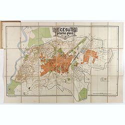
Cesu un apkartnes vadonis ar Cesu pilsetas planu. . .
Uncommon and detailed plan of Cesis and its direct surroundings. Cesis is a town in northeastern Latvia, built in the 13th century and one of the best-preserved medieval ...
- $550 / ≈ €480
Date: Cesu, 1928
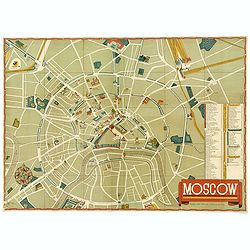
Moscow.
A nice colored lithographic town plan of the Russian capital, in English, published in 1938 in order to promote the U.S.S.R's cultural image overseas during Stalin's term...
- $750 / ≈ €655
Date: Moscow, ca 1938
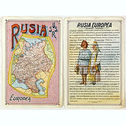
Rusia Europae U.S.S.R.
Detailed map of Russia. Unique manuscript map of Russia. Award-winning manuscript card, prepared by Antonio Raggio for the 11th Congreso de la Union Postal Universal (Wor...
- $450 / ≈ €393
Date: Buenos Aires, 1939
![[Pictorial map of Georgia (Caucasus)].](/uploads/cache/44292-250x250.jpg)
[Pictorial map of Georgia (Caucasus)].
A scarce pictorial map of a region in Georgia in the Caucasus. Map is entirely in Russian, complete with legend at base of map, with small thumbnail pictures and symbols ...
- $150 / ≈ €131
Date: Moscow, 1963
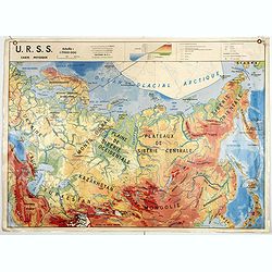
U.S.S.R. Carte Physique. / U.S.S.R. Carte Population.
An unusual school map with on one side a physical map of Russia on verso a map of Russia according to population. Prepared by Pierre Serryn (1916-2002) who was professor ...
- $200 / ≈ €175
Date: St-Germain-en-Laye, 1965
U.S.S.R. Carte Agricole. / U.S.S.R. Carte Industries et communications.
An unusual school map with on one side an agricultural map of Russia on verso a map of Russia showing communication an according to population. Prepared by Pierre Serryn ...
- $200 / ≈ €175
Date: St-Germain-en-Laye, 1965
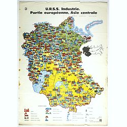
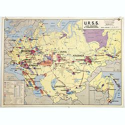
U.R.S.S. Industrie. Partie européenne, Asie centrale. (3)
Map of Eastern Russia. Propaganda poster for Russia's industry. Text in French. Editions de l'Agence de presse Novosti".More about War Maps & Propaganda maps [+]
- $100 / ≈ €87
Date: USSR, 1978
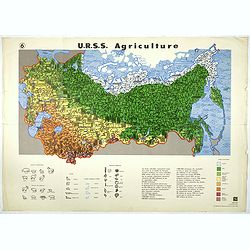
U.R.S.S. Agriculture. (6)
Map of Russia. Propaganda poster for Russia's in and export of industrial goods. With a key in bottom. Text in French. Editions de l'Agence de presse Novosti".More a...
- $100 / ≈ €87
Date: USSR, 1978
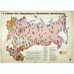
L'Union des Républiques socialistes Soviétiques. (2)
Map of Russia. Propaganda poster showing Russia' s population. With a key. Text in French. Editions de l'Agence de presse Novosti".More about War Maps & Propagan...
- $100 / ≈ €87
Date: USSR, 1978
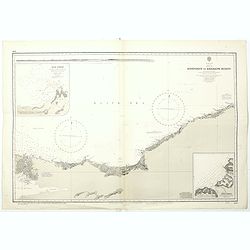
Black sea - Sheet IX - Bosporus to Kerempe Burnu . . .
A highly corrected version of Admiralty chart 2238 originally published 16th June 1854. Edition Date 1980.Detailed chart of Bosporus. With prohibited landing places in pu...
- $100 / ≈ €87
Date: London, 1854-1980
